Regional Transportation Plan Appendices
|
|
|
- Eugenia Chase
- 5 years ago
- Views:
Transcription
1 Regional Transportation Plan Appendices Appendix A: Public Outreach Efforts and Comments Appendix B: Surveys Appendix C: Demographic Trends and Projections Appendix D: Glossary of Transportation Acronyms Regional Transportation Plan Appendices
2 Appendix A Public Outreach Efforts The following is a list of stakeholders that were contacted as part of the public outreach effort in the development of this Regional Transportation Plan. All twenty-six Franklin County town administrators All twenty-six Franklin County town highway departments Town of Greenfield Planning Director Town of Sunderland Energy Committee FRCOG Planning Board Walk Franklin County committee members Franklin County Bikeway Committee members MassDOT Districts 1 and 2 MassDOT Office of Transportation Planning Transportation Planning Organization members Franklin Land Trust Mt. Grace Land Conservation Trust Franklin County Community Development Corporation Franklin Regional Housing and Redevelopment Authority Franklin Regional Transit Authority Greater Franklin County Comprehensive Economic Development Strategy Committee Franklin County Chamber of Commerce Franklin County Selectmen s Association Community Transit Services Stavros Councils on Aging About Town Taxi ACE Cab F.M. Kuzmeskus Connecticut River Watershed Council Indus-Rail Company YMCA Greenfield Community College Baystate Franklin Medical Center Congressman John Olver State Senator Stanley Rosenberg State Representative Stephen Kulik Massachusetts Department of Conservation and Recreation Massachusetts Rehabilitation Commission Massachusetts Historic Commission Massachusetts Department of Housing and Community Development Massachusetts Executive Office of Energy and Environmental Affairs Massachusetts Department of Environmental Protection Federal Highway Administration Federal Transit Administration Federal Railroad Administration Federal Aviation Administration Regional Transportation Plan Appendices
3 Appendix A Public Comments Once the FRCOG staff had completed a draft of the 2012 Regional Transportation Plan, public input was sought from a variety of stakeholders, as well as those required by SAFETEA-LU, during a 30-day public review and comment period between August 8 and September 9, A public meeting was held on September 7, 2011 in the centralized location of Greenfield to directly obtain public input regarding the draft RTP. As part of this outreach, the FRCOG received few substantial comments on the draft RTP. Those comments that were received were reviewed and incorporated, as appropriate, into the RTP during its preparation. The following is a list of comments received during the public meeting. Attached are the comments received from MassDOT and FHWA. Comments Received during the Public Meeting There should be provisions made for biking and walking along Route 78 in Orange. There should be a passenger rail train that runs east to Boston for commuting. What are the passenger rail policies for bike accommodation on-board rail cars? FRCOG should advocate for bike accommodation. The recommended sidewalk along Route 112 to Mohawk Regional High School should also include a bike lane. The RTP should ensure that an effort is made within the county to prepare for the coming fuel shortage and effects from climate change. o The region should be more aggressive in promoting bicycling in Franklin County. o Need more mass transit. Bicycling on the Cheapside Bridge on Route 5/10 towards Deerfield is very dangerous. The road speeds should be lowered at this location. Regional Transportation Plan Vehicle speeds along Route 5/10 in Deerfield should be reevaluated for bike safety. There should be a bike lane on the length of Federal Street in Greenfield. This will make bicycling in the area easier, will help with economic development, and will help with traffic calming. Can FRCOG work to put in a bike lane in a town as a pilot study for other towns to see if it is feasible and the issues involved with it? Can FRTA keep track of how many bicycles are being placed on the bus bike racks? How are the racks being used? There should be more dedicated turn lanes in the county for two reasons. The first reason is driver safety. The other reason is environmental. Less fuel is used when accelerating and de-accelerating is minimized. Turning lanes would help keep through traffic from having to slow for turning vehicles. South River Road in Charlemont is in very bad condition. There is little pavement left and the retaining walls are in poor shape. This road is an alternate to Route 2 for emergencies and the town of Charlemont can afford to repair it. The reconstruction of the General Pierce Bridge should be redesigned to accommodate truck traffic. Specifically, it should be designed to have an increased weight limit of 49 tons. Appendices


4


5
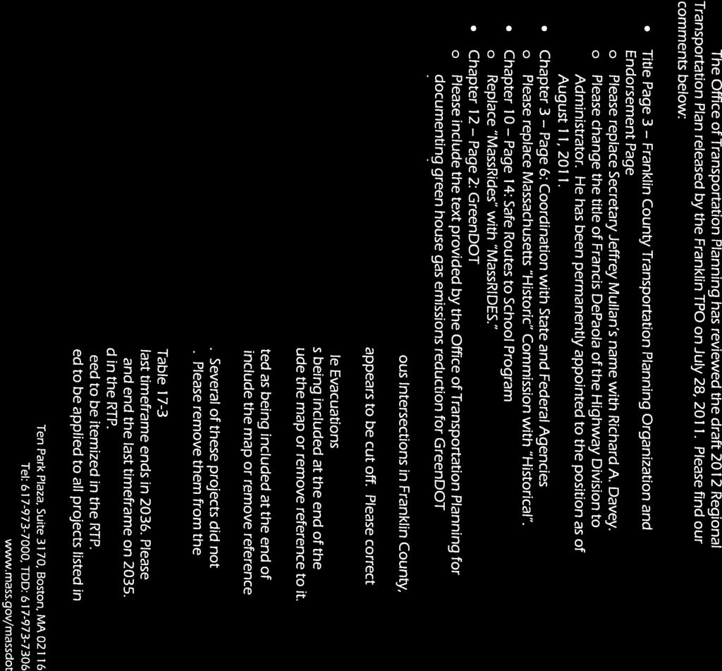
6 General Comments FHWA Comments on the Franklin Region TPO s Draft RTP This draft document does not appear to have included a signatory page for the MPO voting members to sign, signifying that they endorse the RTP. Please include this page in the final document. Chapter 5 Roadway and Bridge Infrastructure This chapter provides the reader with a good understanding of what the existing pavement conditions are and what the estimated cost would be to bring all federal aid eligible roadways (both state and locally owned) up to excellent conditions. This chapter needs to be enhanced by furthering the discussion that such an investment (all up to excellent conditions) is not feasible. The cost to maintain or improve existing conditions at a feasible level of expenditure is missing and needs to be discussed. Since bringing all of these roadways up to excellent pavement conditions is not feasible, what needs to be defined is the amount that is feasible, that will maintain the current conditions, or make an incremental improvement over current pavement conditions. This cost estimate must then be shown in the final financial constraint analysis. One way to do this is to develop another table similar to Table 5-5, which shows a new set of goal conditions and much of the same information as Table 5-5 shows, but with a smaller cost estimate, which will necessarily come as the result of not being able to bring all of these roadways up to excellent conditions. This cost estimate will then need to be plainly shown in the comparison of costs versus revenues, to demonstrate financial constraint. Chapter 7 Passenger Rail No Comments. Chapter 8 Airports No Comments. Chapter 13 Transportation Safety Page 1 - The introduction section of this chapter could talk a bit about Safety being one of the 8 Planning Factors. Page 3 Please define MEV, as it is used in MEV EPDO. This chapter should refer to the fact that the SAFETEA-LU legislation created the Highway Safety Improvement Program (HSIP) and that, as a condition for states to access HSIP funding for eligible projects, states had to create Strategic Highway Safety
7 Plans (SHSPs). This is relevant because the reader should understand that what the SHSP Emphasis Areas are and that the most pressing regional safety needs align at least generally with the SHSP. This connection reinforces that there is coordination between the federal, state and local level, regarding safety planning. Has signal pre-emption been considered for providing emergency vehicles with priority, when reacting to an emergency? If so, this would be relevant to include as an example of regional safety planning efforts. Chapter 14 Transportation Security The introduction section of this chapter could talk a bit about Security being one of the 8 Planning Factors. Page 6 The section entitled Challenges for Large Scale Evacuations refers the reader to a map at the end of the chapter. There was no such map, which may have been an addition to the document, following this chapter being uploaded to the web. Please check that this map is available. Chapter 16 Air Quality Conformity Determination Please rename this chapter to Air Quality Conformity Determination. There is no signatory page in this chapter. Please include a signatory page for all MPO members to sign, collectively certifying that the Plan is in conformance with the State Implementation Plan (SIP). Chapter 17 Recommended Projects All projects that are recommended for construction in a year following 2012 must include a 4% per year inflation factor applied to the cost. Projects shown to advance to construction beyond the time frame currently show a 4% inflation factor. Not only should this inflation factor apply to ALL years beyond 2012, the 4% must be applied per year. The first timeframe shown is Please correct this to show Projects advancing to construction in 2011 should not have their 2011 costs considered in the timeframe. The last timeframe now ends in Please correct this to end in Page 3 In this version, The Bernardston, Rt. 10 bridge project (shown in the timeframe) has an unknown estimated cost. Please ensure that this cost estimate is entered. Page 6 Please ensure that the Deerfield projects (the I-91 northbound and southbound bridge rehabs) require 5 construction seasons to complete the entire project, since Advance Construction is shown to span 5 years.
8 The Greenfield project I-91 over Rt. 5/10, must have a cost estimate entered. As written in the version currently under review, the entry of not sure of amount is provided. Please enter a valid cost estimate. Page 8 The Gill-Montague Bridge rehab is shown to advance to construction in the timeframe. Please denote the use of Advance Construction method of programming, but showing AC-1/x, where x represents the number of years that the project is scheduled to span over. Also, please contact me to ensure that 5 years will be necessary, and to let me know that, while the TPO intends to program funding during 2011, 12, 13,14, and 16, what happens in 2015; why is there no funding programmed in 2015? Page 11 The Leverette, Charlemont, Deerfield-Wately-Sunderland, Deerfield, and Greenfield projects must have a cost estimate represented if these projects are to be included in the recommended (i.e., financially constrained) portion of the RTP. Same comment for each project shown on Page 12. These projects cannot be represented like this for TPO consideration and endorsement. There is no way to demonstrate financial constraint without these costs being accounted for. This requires follow-up prior to requesting TPO endorsement. Pages 13 to 22 As discussed above, please ensure ALL recommended projects have valid and reasonable cost estimates associated with them. Chapter 18 Financial Constraints Page 3 should show Table 18-2, not 17-2; just an apparent typo. It would be most helpful; to create a summary table showing all highway related costs associated with the RTP, for each 5-year timeframe, beginning with The thought being that this bottom line number for each 5-year timeframe, and the aggregated sum of costs throughout the Plan s horizon, can be easily compared to the funding expected to be available for the same timeframes. This comparison should be made explicitly to demonstrate financial constraint. The following comments were previously sent via , on July 14, 2011: Ch1, P3 Under the SAFETEA-LU section, it may be appropriate to mention that SAFETEA-LU is currently being extended, while Congress works to pass a subsequent, long-term law to fund surface transportation. Funding levels in the next bill are uncertain and could be lower than those contained in SAFETEA-LU. This may affect the timeliness of delivering projects that address regional transportation priorities.
9 Ch 1, P5 (Table 1-1) Nice chart with lots of great information. However there are a few entries that did not have a status update in the version I saw. Can an update be provided in the draft that goes out for public review and comment, for the following: #9 - Advance Rt 2 Safety Improvements Ervingside, Farley, #10- Plan for passenger rail from Franklkin County to Boston #13- Implement Safety and Traffic Flow Improvements on Rt 2 between I-91 and Rt 2 rotary And, can the following be updated, providing an estimated timeframe of when these projects may begin: #16- Construct Rt 2 West Safety Improvments #17- Construct a bikeway to connect Orange and Athol Downtowns #18- Realign I-91 northbound exit 24 ramp Ch2 p1 Public Participation The discussion says that the legislation says the consultations should take into account plans, maps, and inventories of natural and or historic resources as available and applicable. My question is- did this occur? Efforts that were made to have this type of consultation need to be documented in the RTP; specifically, with whom was this consultation held and what materials were referred to and shared in the meeting. Ch2 p2 As I read the Initial Public Outreach section, I wanted to recognize the great job the FRCOG has done to make sure public input was incorporated. Nice Job!
10 Ch2 p4 Table 2-1 Reading through the Table, I did not see any representatives from resource agencies like Land Use Management, Historical Preservation, Corps of Engineers, etc I did read the Consideration of Environmental and land Use Issues section and understand the efforts that were made to coordinate and consult with some of those agencies. I didn t read anything about whether long range plans were shared and discussed. It would be helpful to add that detail, or more closely describe what type of consultation was held. I m looking for a better understanding of what level of involvement these entities had in helping to shape the document. A concise entry would be fine. Again, nice efforts. Ch3 In the version of the document that I reviewed, it seems that this chapter will probably be further developed. As written, there are 11 goals with a very brief explanation of each stated goal. If this has not been further developed, I recommend providing the reader with more discussion that links the goals to how they might be realized and why their realization should be considered regional priorities. Ch4 Figure 4-2 Please add the appropriate label of units being measured; i.e., Population (persons) Figure 4-5 Presumably, the Unemployment Rate (Y axis) is being shown in %. These values should be labeled. An example would be to label the axis: Unemployment Rate (%) Figure 4-6 Same comment; i.e., Employment (persons). Also, please include the source. Ch4 Figure 4-8 Please label the Y axis; i.e., Residents Ch5 I have not received this chapter yet. Ch6
11 It would be helpful to show a map of the region, which depicts the various freight corridors (rail and highway) with the approximate volume ($s worth of freight moved, or trips made over the corridors) shown. This would help the reader to gain an appreciation of the volume of freight that moves in, out, and through the region. It might be beneficial to try and show desire lines along the various corridors / routes, where the lines thickness depict the volume (trips), or value (of goods) being moved. Ch9 Figure 9-1 Please label the Y axis; i.e., Riders. Also, please include the source. Figure 9-2 Same comment. Figure 9-3 Same comment. Ch10 While the version of the RTP I read did not include a chapter explicitly called Livability, it was evident to me that this chapter was the closest chapter to where this topic is discussed. FHWA has discussed that RTPs should contain a chapter on livability, and in the best situation, that would be the name of the chapter. I would recommend that Livability be used on the front of chapter 10, perhaps together with Bicycle and Pedestrian Facilities. It also seems that there could be some paragraph or two that could tie livability together with all of the various initiatives you wrote about, in this chapter. I read the references to the National Livable Communities Initiative, GreenDOT, the Global Warming Solutions and the Healthy Transportation Compact, but I think one or two paragraphs should be developed that tie all these programs and initiatives together, to result in making the Franklin County region more livable. There should also be a brief passage that describes specifically what types of projects have been done in the recent past, that address livability goals, and an explanation that takes that passage a step further to give the reader a glimpse of the kinds of initiatives that may be in store for the future of Franklin County. Ideally, I think the Livability chapter should discuss what the term means to the residents and stakeholders of the region and how that meaning translates into potential improvement projects. To me, that should be the foundation of the Livability spin of this chapter, then tie it into the other initiatives you have mentioned. Ch11 No comments
12 Ch12 p7 Devoted to the topic of Climate Change, FHWA provided various advice and guidance for regions to consider, in order to appropriately address climate change initiatives. On strategy that was suggested, was for MPOs to complete an inventory of the transportation infrastructure within the region and consider what threats to the continued service of that infrastructure might exist. From the early version of the RTP I reviewed, it appears that this task has been undertaken at least partially, with regard to the transportation infrastructure that could be impacted by the failure of the Harriman Dam (see plan for More Severe and Frequent Flooding in the Region section). This activity was recommended for the whole region. If this has not been done, it would be appropriate to include a discussion of such a region-wide effort, so that appropriate transportation / disaster planning can occur. Recommendations section The recommendation Continue to promote sustainable and alternative forms of transportation to the singly-occupied motor vehicle may need to be re-worded. Please review this passage again. Ch13 - I have not received this chapter yet. Ch14 - I have not received this chapter yet. Ch15 No comments. For the Pavement Management Chapter- Each region must identify in the RTP, what the existing pavement conditions are, explaining how the data was arrived at. If your region developed that data, you will be able to describe the data collection process and what the breakdown of the conditions are for Franklin County (i.e., 20% excellent, 35% good, 45% poor). Then, the MPO s goals for the future pavement condition should be discussed; it may be a brief discussion like this topic was discussed at an MPO meeting and the policy board decided that the region s roadway conditions should be brought up to the following conditions - 35% excellent, 35% good, 30% poor). The last part of this discussion needs to be a discussion of what the estimated cost would be to the region, in order to
13 bring the pavement to the condition described by the MPO s goals. This will probably not be affordable to the region, so it would be prudent for this discussion to conclude with the most likely, affordable pavement condition, keeping financial responsibility and the need to address other region priorities in mind. The estimated cost that results from the most likely, affordable pavement condition the RTP will be planning for, should be used in the Financial Plan. This is exactly the kind of discussion and analysis that FHWA will be looking for in each of the RTPs. Please call if there are questions on this. For the Safety Chapter I have urged all regions to explain that the Safety priorities in their region tie into the Mass DOT Strategic Highway Safety Plan s (SHSP) Emphasis Areas. While Mass DOT s safety priorities are broad enough to cover many areas of concern, from all around the state, Franklin County s safety concerns may be a smaller subset of those found in the SHSP. That s fine, but what the RTP safety section should do is discuss the region s safety priorities and make the connection to which Emphasis Area of the SHSP they align with. As previously mentioned, the Emphasis Areas are fairly broad in scope, so aligning the regional safety priorities with the SHSP Emphasis Areas (i.e., the State s safety priorities), should not be difficult. This connection can be done very simply in a tabular form or even parenthetically. As a reminder The Draft RTP should not be released without the Air Quality Conformity finding included. Same for the Financial Section. To reiterate recent direction from Mass DOT, this year, targets will not be reduced to observe the inflationary costs of projects beyond the 1 st year of the TIP. Rather, the costs will be inflated by 4% per year after the 1 st year. This will be important not only for the TIP, but the RTP also, as the first time band shown in the RTP s financial Plan shows the TIP years.
14
15 Appendix B Surveys General Transportation Survey Major Employer Transportation Survey Regional Transportation Plan Appendices

16 Transportation Survey The results of this survey will help FRCOG update the Regional Transportation Plan by identifying transportation needs and project recommendations. 1. Please indicate whether you feel each of the following has improved, stayed the same, or gotten worse in the region over the past five years. Stayed the Unsure/No Improved Worsened Same Opinion Other (please specify) 2. Do you ever use Park and Ride lots (formal or informal ones)? Yes No 3. If you do use a Park and Ride Lot, where do you park? This Survey can also be completed online at under What s New?.
 5. Generally, how far is your daily commute (one way) in miles? 6. Where do you live (town name)? (optional) 7.")
17 4. How do you usually travel during your daily routine? Please provide the number of days per week that you use each of the following types of transportation. Number of Days per Week Other (please specify) 5. Generally, how far is your daily commute (one way) in miles? 6. Where do you live (town name)? (optional) 7. What are your top three recommendations for transportation improvements and projects in the region over the next five to 10 years? 1) 2) 3) 8. Do you have any comments that would help us as we update the Regional Transportation Plan? 9. If you would like to be included on our mailing list for the 2011 Regional Transportation Plan planning process and draft materials, please fill out the information below, or contact Megan Rhodes, at (413) ext Name: Mailing Address: Address: Please return this survey to 278 Main St. 4 th Floor, Greenfield, MA or by fax at (413) This Survey can also be completed online at under What s New?.
18 EMPLOYER REGIONAL TRANSPORTATION SURVEY 1. Business Name: 2. Physical Address : 3. Brief Description Business/Industry: 4. Type of Facility: [ ] Factory [ ] Office [ ] Warehouse [ ] Other 5. Estimated 2009 Employees: Full-time Part-time Note: The FRCOG and Franklin County Chamber of Commerce produce a list of major employers and manufacturers in the region. The above employment data will be included in this list. If you do not want employment data used in this manner, please check the following box [ ]. 6. Estimated 2009 Total Annual Payroll: (Optional) Note: Data collected from question #6 will not be released on an individual business basis. 7. Do you use the following to do business? [ ] Truck [ ] Rail [ ] Local Airports [ ] None of these 8. What is your primary means of transporting goods (for either import or export)? 9. Is your facility located adjacent to railroad tracks? If yes, do you use it? If, not would you like to? 10. Are employees able to take a bus or van to work? If no, would there be interest? 11. Comments or recommendations about transportation in Franklin County? 12. Survey completed by: Name and Title: In case of question, telephone or SURVEY FORM CAN ALSO BE FILLED OUT ONLINE AT Please return this survey form: By mail: FRCOG, 425 Main Street, Greenfield, MA 01301, Attn: Megan Rhodes By mrhodes@frcog.org, By Fax: (413) Questions? Call Megan Rhodes at (413) x110
19 Appendix C Demographic Trends and Projections Appendix Table 1: Labor Force, Employment, and Unemployment by Town, 2009 Appendix Table 2: Population Forecasts for Franklin County Towns, 2000 to 2035 Appendix Table 3: Projected Town Population Distributions by Age Group, 2010 Appendix Table 4: Projected Town Population Distributions by Age Group, 2020 Appendix Table 5: Projected Town Population Distributions by Age Group, 2030 Appendix Table 6: Projected Town Population Distributions by Age Group, 2035 Appendix Table 7: Employment Forecasts for Franklin County Towns, 2009 to 2035 Regional Transportation Plan Appendices
20 Appendix Table 1: Labor Force, Employment, and Unemployed by Town, 2009 Location of Residence Labor Force Employed Persons Unemployed Persons Unemployment Rate Ashfield 1,108 1, % Bernardston 1,227 1, % Buckland 1,106 1, % Charlemont % Colrain % Conway 1,150 1, % Deerfield 2,796 2, % Erving % Gill % Greenfield 9,098 8, % Hawley % Heath % Leverett 1, % Leyden % Monroe % Montague 4,319 3, % New Salem % Northfield 1,742 1, % Orange 3,835 3, % Rowe % Shelburne 1, % Shutesbury 1,128 1, % Sunderland 2,285 2, % Warwick % Wendell % Whately % Franklin County 39,167 36,069 3, % * The labor force refers to the number of residents in a town who are either employed (anywhere) or who are actively looking for work. Source: Massachusetts Department of Workforce Development, 2009 Regional Transportation Plan Appendices
21 Appendix Table 2: Population Forecasts for Franklin County Towns, 2000 to U.S. Census 2009 U.S. Census 2010 U.S. Census 2017 Projected 2020 Projected 2025 Projected Geographic Area Population Population Population Population Population Population Population Population Number Percent % Ashfield 1,800 1,827 1,737 1,790 1,810 1,820 1,860 1, % Bernardston 2,155 2,235 2,129 2,200 2,220 2,230 2,270 2, % Buckland 1,991 1,989 1,902 1,960 1,980 2,000 2,030 2, % Charlemont 1,358 1,386 1,266 1,310 1,320 1,330 1,350 1, % Colrain 1,813 1,855 1,671 1,720 1,740 1,750 1,780 1,800 (13) -0.7% Conway 1,809 1,899 1,897 1,960 1,980 1,990 2,030 2, % Deerfield 4,750 4,692 5,125 5,290 5,340 5,380 5,470 5, % Erving 1,467 1,549 1,800 1,860 1,870 1,890 1,920 1, % Gill 1,363 1,396 1,500 1,550 1,560 1,570 1,600 1, % Greenfield 18,168 17,537 17,456 18,000 18,200 18,300 18,600 18, % Hawley % Heath (35) -4.3% Leverett 1,663 1,787 1,851 1,910 1,930 1,940 1,980 2, % Leyden (2) -0.3% Monroe % Montague 8,489 8,175 8,437 8,700 8,780 8,850 9,010 9, % New Salem ,020 1,030 1,040 1,060 1, % Northfield 2,951 3,311 3,032 3,130 3,160 3,180 3,240 3, % Orange 7,518 7,699 7,839 8,080 8,160 8,230 8,370 8, % Rowe % Shelburne 2,058 2,031 1,893 1,950 1,970 1,990 2,020 2,040 (18) -0.9% Shutesbury 1,810 1,836 1,771 1,830 1,840 1,860 1,890 1, % Sunderland 3,777 3,909 3,684 3,800 3,840 3,870 3,930 3, % Warwick % Wendell 986 1, (66) -6.7% Whately 1,573 1,573 1,496 1,540 1,560 1,570 1,600 1, % Franklin County 71,535 71,778 71,372 73,600 74,300 74,900 76,200 77,000 5, % Sources: 2010 Population: U.S. Census Redistricting Summary Data; Population projections: MassDOT, developed in coordination with FRCOG, Regional Transportation Plan Appendices 2030 Projected 2035 Projected Population Change
22 Appendix Table 3: Projected Town Population Distributions by Age Group, Population in Geographic each Age Group Area 2010 Census Population Under Age 14 Age Age Age Age 65 & over Under Age 14 Percentage of 2010 Population in each Age Group Age 15- Age 25- Age Ashfield 1, % 10.2% 7.9% 52.0% 11.7% Bernardston 2, , % 12.8% 7.8% 47.4% 16.3% Buckland 1, % 15.1% 8.1% 46.1% 13.4% Charlemont 1, % 13.0% 10.7% 44.9% 11.7% Colrain 1, % 12.4% 10.2% 44.3% 12.4% Conway 1, % 11.7% 7.9% 52.5% 9.6% Deerfield 5, , % 11.1% 9.6% 48.7% 13.9% Erving 1, % 12.5% 12.7% 44.4% 13.9% Gill 1, % 12.2% 7.0% 50.2% 12.9% Greenfield 17,456 2,824 2,402 1,923 7,233 3, % 13.8% 11.0% 41.4% 17.6% Hawley % 8.4% 8.5% 50.3% 15.0% Heath % 13.1% 7.7% 48.3% 10.4% Leverett 1, % 14.0% 6.2% 51.8% 11.3% Leyden % 12.3% 6.8% 52.6% 7.9% Monroe % 15.2% 8.9% 40.8% 17.3% Montague 8,437 1,470 1, ,539 1, % 13.0% 11.0% 41.9% 16.7% New Salem % 8.8% 7.8% 54.9% 10.0% Northfield 3, , % 13.0% 8.5% 45.7% 13.6% Orange 7,839 1,580 1, ,344 1, % 13.4% 9.3% 42.7% 14.5% Rowe % 9.0% 5.0% 52.5% 18.9% Shelburne 1, % 12.5% 6.6% 45.8% 20.6% Shutesbury 1, % 13.2% 7.1% 52.9% 5.9% Sunderland 3, , % 25.7% 16.4% 35.7% 8.5% Warwick % 11.9% 7.3% 50.4% 11.2% Wendell % 15.0% 11.2% 51.5% 4.7% Whately 1, % 11.4% 8.7% 51.3% 12.4% Age 65 & over Franklin County 71,372 12,414 9,659 7,068 32,001 10, % 13.5% 9.9% 44.8% 14.3% Sources: 2010 Population: U.S. Census Bureau, Redistricting Summary Data; Population projections: MassDOT, developed in coordination with FRCOG, Regional Transportation Plan Appendices
23 Appendix Table 4: Projected Town Population Distributions by Age Group, Population in 2020 each Age Group Geographic Area Projected Population Under Age 14 Age Age Age Age 65 & over Under Age 14 Regional Transportation Plan Appendices Percentage of 2020 Population in each Age Group Age 15- Age 25- Age Ashfield 1, % 8.8% 8.9% 49.4% 15.0% Bernardston 2, % 11.4% 8.8% 44.8% 19.6% Buckland 1, % 13.7% 9.1% 43.5% 16.6% Charlemont 1, % 11.6% 11.7% 42.3% 14.9% Colrain 1, % 11.0% 11.2% 41.7% 15.6% Conway 1, % 10.3% 8.8% 49.9% 12.8% Deerfield 5, , % 9.7% 10.6% 46.1% 17.1% Erving 1, % 11.1% 13.6% 41.8% 17.1% Gill 1, % 10.8% 8.0% 47.6% 16.1% Greenfield 18,200 2,908 2,249 2,177 7,070 3, % 12.4% 12.0% 38.8% 20.9% Hawley % 7.0% 9.5% 47.7% 18.3% Heath % 11.7% 8.6% 45.7% 13.7% Leverett 1, % 12.5% 7.1% 49.2% 14.6% Leyden % 10.9% 7.8% 50.0% 11.1% Monroe % 13.8% 9.8% 38.2% 20.6% Montague 8,780 1,512 1,017 1,047 3,456 1, % 11.6% 11.9% 39.4% 19.9% New Salem 1, % 7.4% 8.8% 52.3% 13.3% Northfield 3, , % 11.6% 9.4% 43.1% 16.8% Orange 8,160 1, ,269 1, % 12.0% 10.3% 40.1% 17.7% Rowe % 7.6% 5.9% 49.9% 22.2% Shelburne 1, % 11.1% 7.6% 43.2% 23.8% Shutesbury 1, % 11.8% 8.0% 50.3% 9.1% Sunderland 3, , % 24.3% 17.3% 33.1% 11.8% Warwick % 10.5% 8.3% 47.8% 14.4% Wendell % 13.6% 12.2% 48.9% 7.9% Whately 1, % 10.0% 9.6% 48.7% 15.7% Age 65 & over Franklin County 74,300 12,774 9,014 8,059 31,387 13, % 12.1% 10.8% 42.2% 17.6% Sources: 2010 Population: U.S. Census Bureau, Redistricting Summary Data; Population projections: MassDOT, developed in coordination with FRCOG, 2011.
24 Appendix Table 5: Projected Town Population Distributions by Age Group, Population in 2030 each Age Group Geographic Area Projected Population Under Age 14 Age Age Age Age 65 & over Under Age 14 Percentage of 2030 Population in each Age Group Age 15- Age 25- Age Ashfield 1, % 8.5% 7.5% 46.9% 18.9% Bernardston 2, % 11.1% 7.4% 42.3% 23.5% Buckland 2, % 13.4% 7.7% 41.0% 20.6% Charlemont 1, % 11.2% 10.3% 39.8% 18.9% Colrain 1, % 10.7% 9.8% 39.2% 19.6% Conway 2, % 10.0% 7.4% 47.4% 16.8% Deerfield 5, ,383 1, % 9.4% 9.2% 43.6% 21.1% Erving 1, % 10.8% 12.2% 39.3% 21.1% Gill 1, % 10.5% 6.6% 45.0% 20.1% Greenfield 18,600 3,026 2,237 1,967 6,756 4, % 12.0% 10.6% 36.3% 24.8% Hawley % 6.7% 8.1% 45.2% 22.2% Heath % 11.3% 7.3% 43.2% 17.6% Leverett 1, % 12.2% 5.7% 46.7% 18.5% Leyden % 10.5% 6.4% 47.5% 15.1% Monroe % 13.5% 8.4% 35.7% 24.5% Montague 9,010 1,578 1, ,319 2, % 11.3% 10.5% 36.8% 23.9% New Salem 1, % 7.1% 7.4% 49.7% 17.2% Northfield 3, , % 11.2% 8.1% 40.6% 20.8% Orange 8,370 1, ,142 1, % 11.6% 8.9% 37.5% 21.7% Rowe % 7.2% 4.5% 47.4% 26.1% Shelburne 2, % 10.8% 6.2% 40.7% 27.8% Shutesbury 1, % 11.5% 6.6% 47.8% 13.1% Sunderland 3, , % 23.9% 15.9% 30.5% 15.7% Warwick % 10.2% 6.9% 45.3% 18.4% Wendell % 13.2% 10.8% 46.4% 11.9% Whately 1, % 9.6% 8.2% 46.2% 19.7% Age 65 & over Franklin County 76,200 13,321 8,994 7,207 30,274 16, % 11.8% 9.5% 39.7% 21.5% Sources: 2010 Population: U.S. Census Bureau, Redistricting Summary Data; Population projections: MassDOT, developed in coordination with FRCOG, Regional Transportation Plan Appendices
25 Appendix Table 6: Projected Town Population Distributions by Age Group, Population in 2035 each Age Group Geographic Area Projected Population Under Age 14 Age Age Age Age 65 & over Under Age 14 Percentage of 2035 Population in each Age Group Age 15- Age 25- Age Ashfield 1, % 8.3% 6.8% 45.6% 20.9% Bernardston 2, % 10.9% 6.7% 41.0% 25.5% Buckland 2, % 13.2% 7.0% 39.7% 22.6% Charlemont 1, % 11.1% 9.6% 38.5% 20.9% Colrain 1, % 10.5% 9.1% 37.9% 21.5% Conway 2, % 9.8% 6.7% 46.1% 18.7% Deerfield 5, ,339 1, % 9.2% 8.5% 42.3% 23.1% Erving 1, % 10.6% 11.5% 38.1% 23.1% Gill 1, % 10.3% 5.9% 43.8% 22.1% Greenfield 18,800 3,086 2,230 1,857 6,591 5, % 11.9% 9.9% 35.1% 26.8% Hawley % 6.5% 7.4% 43.9% 24.2% Heath % 11.2% 6.6% 41.9% 19.6% Leverett 2, % 12.1% 5.1% 45.4% 20.5% Leyden % 10.4% 5.7% 46.3% 17.1% Monroe % 13.3% 7.7% 34.4% 26.5% Montague 9,100 1,607 1, ,237 2, % 11.1% 9.8% 35.6% 25.8% New Salem 1, % 6.9% 6.7% 48.5% 19.2% Northfield 3, , % 11.1% 7.4% 39.3% 22.7% Orange 8,460 1, ,069 2, % 11.5% 8.2% 36.3% 23.7% Rowe % 7.1% 3.8% 46.2% 28.1% Shelburne 2, % 10.6% 5.5% 39.5% 29.7% Shutesbury 1, % 11.3% 5.9% 46.6% 15.0% Sunderland 3, , % 23.8% 15.2% 29.3% 17.7% Warwick % 10.0% 6.2% 44.0% 20.4% Wendell % 13.1% 10.1% 45.1% 13.9% Whately 1, % 9.5% 7.5% 44.9% 21.6% Age 65 & over Franklin County 77,000 13,577 8,961 6,746 29,617 18, % 11.6% 8.8% 38.5% 23.5% Sources: 2010 Population: U.S. Census Bureau, Redistricting Summary Data; Population projections: MassDOT, developed in coordination with FRCOG, Regional Transportation Plan Appendices
26 Appendix Table 7: Employment Forecasts for Franklin County Towns, 2009 to ES Projected 2017 Projected 2020 Projected 2025 Projected 2030 Projected 2035 Projected Employment Change Geographic Area Employment Employment Employment Employment Employment Employment Employment Number Percent % Ashfield % Bernardston % Buckland % Charlemont % Colrain % Conway % Deerfield 4,416 4,440 4,480 4,560 4,650 4,750 4, % Erving % Gill % Greenfield 9,682 9,740 9,810 10,000 10,190 10,420 10, % Hawley % Heath % Leverett % Leyden % Monroe % Montague 2,816 2,830 2,850 2,910 2,960 3,030 3, % New Salem % Northfield % Orange 1,928 1,940 1,950 1,990 2,030 2,080 2, % Rowe % Shelburne % Shutesbury % Sunderland % Warwick % Wendell % Whately 1,019 1,030 1,030 1,050 1,070 1,100 1, % Franklin County 25,650 25,800 26,000 26,500 27,000 27,600 28,200 2,550 10% Sources: 2000 Population: U.S. Census Bureau; Population projections: MassDOT, developed in coordination with FRCOG, Regional Transportation Plan Appendices
27 Appendix D Glossary of Transportation Acronyms 3C AASHTO Continuing, Cooperative, and Comprehensive transportation planning and programming American Association of State Highway and Transportation Officials Name of Franklin County s primary transportation planning grant. An agency that, among other functions, sets standards for roads, highways and bridges. ADA American with Disabilities Act Federal legislation prohibiting discrimination on the basis of disability. AADT Average Annual Daily Traffic Average 24-hour traffic volume using a particular roadway over an entire year. ADT Average Daily Traffic Average 24-hour traffic volume using a particular roadway. AGR Average Growth Rate Annual growth rate for traffic. AIP Airport Improvement Program Federal program run through the FAA that provides grants to public agencies for the planning and development of public-use airports. ALP Airport Layout Plan A scaled drawing depicting existing and future facilities and property necessary for the operation and development of the airport. ANR Approval-Not-Required A property lot that does not require a site plan review for development if it meets the town s requirements of abutting a qualified way and meets frontage and area requirements. ASMP Airport Safety and Maintenance Program A program that is meant to provide a safe and operable facility for the least possible cost. BLS U.S. Bureau of Labor Statistics Principal fact-finding agency for the Federal Government in the broad field of labor economics and statistics. BRTA Berkshire Regional Transit Authority The transit authority in Berkshire County. Regional Transportation Plan Appendices
28 BTS Bureau of Transportation Statistics Part of the U.S. Department of Transportation, BTS compiles, analyzes, and makes accessible information on the Nation's transportation systems. CAAA Clean Air Act Amendments Federal legislation that sets levels for air pollutants. In regions where these levels are not met, methods must be devised and enacted within a specified time period to meet standards. CDAG Community Development Action Grant Federal program that provides funding for publicly owned or managed projects in order to stimulate economic development activities that will leverage private investment, create/retain jobs for low- and moderateincome persons, and address the needs of deteriorated and disinvested neighborhoods. CEDS CEM Comprehensive Economic Development Strategy Comprehensive Emergency Management Plans Program that provides coordinated regional economic development planning for the twenty-six towns in Franklin County plus the towns of Amherst, Athol and Phillipston. Plans designed to guide the organizational behavior before, during and after a disaster in order to mitigate, prepare for, respond to, and recover from the effects of natural, technological and human-caused hazards. CERT Community Emergency Response Teams Teams of organized volunteers that are trained to assist emergency response staff when a disaster occurs. CMAQ Congestion Mitigation and Air Quality Improvement Program A funding category of TEA-21 and SAFETEA-LU, specifically to be used for projects that reduce or prevent an increase in auto emissions. CO Carbon monoxide Air pollutant; auto tailpipe emission. CTAA Community Transportation Association of America Non-profit association that promotes an accessible and mobile society and supports transit services in rural areas. CTS Community Transit Services Private transit provider operating in the Athol- Orange area; provider is part of the CTAA. Regional Transportation Plan Appendices
29 DCR Department of Conservation and Recreation State agency that is responsible for land management and natural resource planning. DCS Division of Conservation Services Part of the Massachusetts Executive Office of Energy and Environmental Affairs, provides technical and financial assistance to farmers as well as public and private land owners in matters dealing with farm plans or sediment and erosion control. DDS Department of Developmental Services State agency responsible for providing assistance in job placement, transportation, housing, or intense levels of treatment, monitoring and care for individuals with intellectual disabilities. DEP Department of Environmental Protection State agency responsible for ensuring State compliance with CAAA and other related federal regulations. DHCD Department of Housing and Community Development State agency responsible for overseeing home ownership, low-income housing assistance, fair housing laws, homelessness, aid for distressed neighborhoods, and housing development programs. DMA Division of Medical Assistance State agency responsible for administering Medicaid and the State Children's Health Insurance Program. DOT Department of Transportation Federal cabinet-level agency that sets standards and policies for all modes of transportation. DRWA Deerfield River Watershed Association Non-profit organization that works to preserve, protect, and enhance the natural resources of the Deerfield River watershed in south-eastern Vermont and north-western Massachusetts. DTA Department of Transitional Assistance State agency responsible for administering public assistance programs for needy citizens of the Commonwealth DWD Department of Workforce Development State agency (formerly DET) that provides services in employment, training, technical and further education and youth affairs. Regional Transportation Plan Appendices
30 EDA Economic Development Administration Federal agency that promotes economic development. EIR Environmental Impact Report Complete assessment of the environmental impacts and benefits of a proposed project to be fully disclosed and reviewed by public agencies, project proponents and the general public. ENF Environmental Notification Form Initial assessment of the environmental impacts of a proposed project. Upon review of an ENF, the Secretary of the Executive Office of Environmental Affairs determines whether an EIR is required. EPDO Equivalent Property Damage Only Method of evaluating the safety of a roadway location that takes into account total number of crashes at a location and the severity of each crash EOEEA Executive Office of Energy and Environmental Affairs. Massachusetts cabinet-level agency that sets standards and policies related to energy and the environment. In 2007, the former EOEA (Executive Office of Environmental Affairs) was expanded to include the Department of Public Utilities and the Division of Energy Resources. EOPS Executive Office of Public Safety State agency responsible for public safety. EPA Environmental Protection Agency Federal agency responsible for ensuring State compliance with CAAA other related federal regulations. EPCRA Emergency Planning and Community Right to Know Act Federal law designed to help local communities prepare emergency plans and protect public health, safety, and the environment from chemical hazards. EPZ Emergency Planning Zone Approximately ten miles surrounding a nuclear power plant. Within this zone, specific emergency protective plans have been developed. FCRN Franklin County Resource Network Organization that serves as an information clearinghouse and source of mutual support for a diverse group of community service agency staff. Regional Transportation Plan Appendices
31 FAA Federal Aviation Administration Federal agency primarily responsible for the advancement, safety and regulation of civil aviation. FCTPO Franklin County Transportation Planning Organization Organization responsible for Franklin County s transportation planning. FEMA Federal Emergency Management Agency Agency of the US government tasked with Disaster Mitigation, Preparedness, Response & Recovery planning. FHWA Federal Highway Administration Federal agency responsible for administering federal highway funding and ensuring State compliance with SAFETEA-LU and other related federal regulations. FRA Federal Railroad Administration Federal agency responsible for safe and environmentally sound rail transportation. FRCOG Franklin Regional Council of Governments Agency that serves the 26 municipalities of Franklin County. FRPB Franklin Regional Planning Board Advisory Board to the Planning staff and the FRCOG comprised of local elected officials, their designees, and at-large members. FRTA Franklin Regional Transit Authority Primary transit authority operating in Franklin County. FTA Federal Transit Authority Federal agency responsible for administering federal transit funding and ensuring State compliance with SAFETEA-LU, ADA, and other related federal regulations. FY Fiscal Year The state fiscal year runs from July 1 st to June 30 th. FFY Federal Fiscal Year The federal fiscal year begins on October 1 st and ends on September 30 th. GIS Geographic Information Systems Computerized mapping hardware and software that creates maps which link geographic information and data stored in a database. Regional Transportation Plan Appendices
32 HMEP Regional Hazardous Materials Emergency Plan Planning and guidance document that provides resources and recommendations for the development of town-level comprehensive emergency management plans. HPMS Highway Performance Monitoring System National level highway information system that includes data on the extent, condition, performance, use, and operating characteristics of the Nation's highways. HSIP Highway Safety Improvement Program Program that outlines the components for the planning, implementation and evaluation of safety programs and projects. ISTEA Intermodal Surface Transportation Efficiency Act of 1991 Former federal transportation legislation that restructured and increased transportation funding and required regional and local input into long term, comprehensive transportation planning. ISTEA was in effect from 1991 to ITS Intelligent Transportation Systems High-tech communication and computer systems that connect, coordinate and control transportation systems. JARC Job Access and Reverse Commute Federal program designed to increase the transportation options of low-income workers. MAA Mutual Aid Agreement A mutual aid agreement is a mutual understanding or promise between jurisdictions, organizations, and companies to help each other during a disaster or emergency. MAC Massachusetts Aeronautics Commission Group of 12 professionals providing services to the aviation community and the citizens of Massachusetts. MARPA MART Massachusetts Association of Regional Planning Agencies Montachusett Area Regional Transit Authority Statewide organization composed of the commonwealth's 13 regional planning agencies. Transit authority for the Montachusett area. Regional Transportation Plan Appendices
33 MEMA MISER Massachusetts Emergency Management Agency Massachusetts Institute of Social and Economic Research State agency responsible for coordinating all emergency response activities in the state from possible terrorist strikes, to hazardous spills, to flooding. Former research institute at the University of Massachusetts; it is now part of the Donahue Institute, also based at UMass. It collected and analyzed information from the U.S. Census and other data sources and made it available to the public. MPO Metropolitan Planning Organization Transportation planning body that serves a population of 200,000 people or more. Although the Franklin County Transportation Planning Organization is not an MPO, it acts as one for transportation planning activities in the Franklin Region. MOU Memorandum of Understanding Legal document describing a bilateral agreement between parties. MRC Medical Reserve Corps Group that establishes teams of local volunteer medical and public health professionals who can contribute their skills and expertise throughout the year and during times of community need. MRPC Montachusett Regional Planning Commission Regional planning body for the 21 municipalities of the Montachusett Region. NAAQS National Ambient Air Quality Standards The EPA sets National Ambient Air Quality Standards (40 CFR part 50) for pollutants considered harmful to public health and the environment. NBI National Bridge Inventory Database, compiled by the Federal Highway Administration, with information on all bridges and tunnels in the United States that have roads passing above or below. NECR New England Central Railroad Subsidiary of RailAmerica. The railroad runs from New London, Connecticut, to East Alburg, Vermont. Regional Transportation Plan Appendices
Healthy Communities Grants Announcement & Information
 Healthy Communities Grants Announcement & Information Introduction If you had the resources, what would you do to make your community a healthier place to live, work and play? We know the people in the
2007 Annual List of Obligated Projects
 This document is available in accessible formats when requested five days in advance. This document was prepared and published by the Memphis Metropolitan Planning Organization and is prepared in cooperation
Overview of the Regional Transportation Improvement Program
 Overview of the 2017-2020 Regional Transportation Improvement Program Table of Contents What is the Puget Sound Regional Council (PSRC)?... 1 What is the Transportation Improvement Program (TIP)?... 1
Appendix 5 Freight Funding Programs
 5. Chapter Heading Appendix 5 Freight Programs Table of Contents 4.1 Surface Transportation Block Grant (STBG);... 5-1 4.2 Transportation Investment Generating Economic Recovery Discretionary Grant Program
Transportation Funding Terms and Acronyms Unraveling the Jargon
 Funding Terms and Acronyms Unraveling the Jargon Every profession has its own acronyms and jargon. The shorthand wording makes it easier and quicker for professionals in any given field to communicate
Transportation Alternatives Program Application For projects in the Tulsa Urbanized Area
 FFY 2015-2016 Transportation Alternatives Program Application For projects in the Tulsa Urbanized Area A Grant Program of Moving Ahead for Progress in the 21st Century (MAP-21) U.S. Department of Transportation
Appendix E: Grant Funding Sources
 Appendix E: Grant Funding Sources Federal Programs The majority of public funds for bicycle, pedestrian, and trails projects are derived through a core group of federal and state programs. Federal funding
2018 POLICY FRAMEWORK FOR PSRC S FEDERAL FUNDS
 2018 POLICY FRAMEWORK FOR PSRC S FEDERAL FUNDS TABLE OF CONTENTS Section 1: Background... 3 A. Policy Framework... 3 B. Development of the 2019-2022 Regional Transportation Improvement Program (TIP)..
PUBLIC PARTICIPATION PLAN
 0 PUBLIC PARTICIPATION PLAN GENERAL The City of Tyler currently serves as the fiscal agent for the Tyler Area Metropolitan Planning Organization (MPO), which represents the Tyler Metropolitan Study Area.
SUMMARY OF THE GROW AMERICA ACT As Submitted to Congress on April 29, 2014
 SUMMARY OF THE ACT As Submitted to Congress on April 29, 2014 The U.S. Department of Transportation (USDOT) submitted the Generating Renewal, Opportunity, and Work with Accelerated Mobility, Efficiency,
SMALL CITY PROGRAM. ocuments/forms/allitems.
 SMALL CITY PROGRAM The Small City Program provides Federal funds to small cities with populations from 5,000 to 24,999 that are NOT located within Metropolitan Planning Organizations' boundaries. Currently
SAFETEA-LU. Overview. Background
 SAFETEA-LU This document provides information related to the Safe, Accountable, Flexible, Efficient Transportation Equity Act: A Legacy for Users (SAFETEA-LU) that was previously posted on the Center for
HOW DOES A PROJECT GET INTO THE STIP?
 HOW DOES A PROJECT GET INTO THE STIP? The Statewide Transportation Improvement Program, known as the STIP, is a list that shows prioritization, funding, and scheduling of transportation projects and programs
FUNDING SOURCES. Appendix I. Funding Sources
 Appendix I. Funding Sources FUNDING SOURCES planning and related efforts can be funded through a variety of local, state, and federal sources. However, these revenues have many guidelines in terms of how
Regional Transportation Plan: APPENDIX B
 Regional Transportation Plan: 2007-2030 Appendix B APPENDIX B POTENTIAL FUNDING SOURCES Funding sources for transportation improvement projects are needed if the recommended projects of the Transportation
Table to accompany Insight on the Issues 39: Policy Options to Improve Specialized Transportation
 Table to accompany Insight on the Issues 39: Policy Options to Improve Specialized Transportation Key Characteristics of the Section 5310, JARC, and New Freedom Programs Formal name Elderly Individuals
TRANSPORTATION ALTERNATIVES (TA) SET ASIDE PROGRAM July 2016
 SET ASIDE PROGRAM July 2016") Regional Transportation Commission TRANSPORTATION ALTERNATIVES (TA) SET ASIDE PROGRAM July 2016 Contents 1.0 Purpose and Eligibility... 2 2.0 Process... 5 3.0 Implementation of Funded Projects... 5 Attachment
Regional Transportation Commission TRANSPORTATION ALTERNATIVES (TA) SET ASIDE PROGRAM July 2016 Contents 1.0 Purpose and Eligibility... 2 2.0 Process... 5 3.0 Implementation of Funded Projects... 5 Attachment
Deval Patrick, Governor Timothy P. Murray, Lieutenant Governor Jeffrey B. Mullan, Secretary of Transportation and Chief Executive Officer
 Ca p i ta l In v e s t m e n t Pl a n September 2010 Deval Patrick, Governor Timothy P. Murray, Lieutenant Governor Jeffrey B. Mullan, Secretary of Transportation and Chief Executive Officer Chapterone
Summary of. Overview. existing law. to coal ash. billion in FY. funding in FY 2013 FY 2014
 H.R. 4348, THE MOVING AHEAD FOR PROGRESS IN THE 21ST CENTURY ACT CONFERENCE REPORT Summary of Key Highway and Research Provisions The following summary is intended to highlight thee highway and research
CALVERT - ST. MARY S METROPOLITAN PLANNING ORGANIZATION
 CALVERT - ST. MARY S METROPOLITAN PLANNING ORGANIZATION TRANSPORTATION IMPROVEMENT PROGRAM FISCAL YEARS 2015-2018 Calvert County Planning Commission St. Mary s County Department of County Services Plaza
DRAFT JARC FUNDING APPLICATION January 29, 2013
 DRAFT JARC FUNDING APPLICATION January 29, 2013 Job Access and Reverse Commute (JARC) Program Introduction The Safe, Accountable, Flexible, Efficient Transportation Act, a Legacy for Users (SAFETEA-LU)
PINELLAS COUNTY DEO#12-1ESR
 Agenda Item #3.H.11 02/13/12 LOCAL GOVERNMENT COMPREHENSIVE PLAN PROPOSED AMENDMENT REPORT PINELLAS COUNTY DEO#12-1ESR 1 THIS PAGE INTENTIONALLY LEFT BLANK 2 PINELLAS COUNTY LPA 22-10-11 Expedited State
REQUEST FOR PROPOSALS
 REQUEST FOR PROPOSALS Town of Hope Mills Multi-Modal Congestion Management Plan September 19, 2016 Fayetteville Area Metropolitan Planning Organization Proposal Due Date: 3:00 PM Eastern Time, 28 th October,
2018 Regional Project Evaluation Criteria For PSRC s FHWA Funds
 2018 Regional Project Evaluation Criteria For PSRC s FHWA Funds INTRODUCTION As described in the adopted 2018 Policy Framework for PSRC s Federal Funds, the policy focus for the 2018 project selection
DCHC MPO Funding Source Overview & Guidance draft January 2015
 DCHC MPO ing Overview & Guidance draft January 2015 General Ratio APD Bond R CMAQ DP SHRP Appalachian Development Highway Revenue Bond Congestion Mitigation and Air Quality Demonstration, Priority, and
DRAFT FUNDING APPLICATION October 20, 2010
 DRAFT FUNDING APPLICATION October 20, 2010 Job Access and Reverse Commute (JARC) Program Introduction The Job Access and Reverse Commute (JARC) program has had a dramatic impact on the lives of thousands
Transportation Planning Prospectus
 Nashville Area Metropolitan Planning Organization Transportation Planning Prospectus Effective October 1, 2017 Nashville Area Metropolitan Planning Organization 138 Second Avenue North Nashville, Tennessee
MID-HUDSON VALLEY TRANSPORTATION MANAGEMENT AREA JOB ACCESS AND REVERSE COMMUTE & NEW FREEDOM PROGRAMS GRANT APPLICATION.
 MID-HUDSON VALLEY TRANSPORTATION MANAGEMENT AREA JOB ACCESS AND REVERSE COMMUTE & NEW FREEDOM PROGRAMS GRANT APPLICATION January 2009 O C T C Introduction The three transportation councils within the Mid-Hudson
Purpose. Funding. Eligible Projects
 SMART SCALE is a statewide program that distributes funding based on a transparent and objective evaluation of projects that will determine how effectively they help the state achieve its transportation
Northern Arizona Council of Governments Annual Work Program Amendment 1
 Northern Arizona Council of Governments Annual Work Program Amendment 1 State Fiscal Year 2017 July 1, 2016 June 30, 2017 I. Work Program Purpose Each year the Arizona Department of Transportation Multimodal
Title VI: Public Participation Plan
 Whatcom Council of Governments Public Participation Plan Adopted October 14, 2009 Updated November 12, 2014 Whatcom Council of Governments 314 East Champion Street Bellingham, WA 98225 (360) 676 6974 Whatcom
Transportation Planning in the Denver Region
 The Prospectus Transportation Planning in the Denver Region TAC Draft (as of June 16, 2011) Approved December 2004 Revised November 2006 Revised August 2007 Revised March 2009 Revised 2011 Key revisions
TRANSPORTATION FUNDING PROGRAMS
 APPENDIX A Note: Not yet edited by DCPD. TRANSPORTATION FUNDING PROGRAMS 6 Transportation Funding Programs The following provides a brief description of transportation related funding programs that are
Implementation. Implementation through Programs and Services. Capital Improvements within Cambria County
 The transportation system serves Cambria County communities because people make decisions and take action toward the stated goals of the long-range transportation plan. Locally, these people include officials
Cass County Rural Task Force Call for Projects Deadline: December 12, 2018
 Cass County Rural Task Force 2020-2023 Call for Projects Deadline: December 12, 2018 The Southwest Michigan Planning Commission (SWMPC) is pleased to announce the Call for Projects for the Cass County
APPENDIX METROFUTURE OVERVIEW OVERVIEW
 APPENDIX B METROFUTURE OVERVIEW OVERVIEW Land use decisions and many economic development decisions in Massachusetts are controlled directly by local municipalities through zoning. This planning is guided
Capital District September 26, 2017 Transportation Committee. The Community and Transportation Linkage Planning Program for
 Capital District September 26, 2017 Transportation Committee The Community and Transportation Linkage Planning Program for 2018-19 Introduction The Community and Transportation Linkage Planning Program
Transportation Alternatives (TA) Northeast Minnesota Workshop
 Northeast Minnesota Workshop") Transportation Alternatives (TA) Northeast Minnesota Workshop October 4 th, 2016 1 What are TA Projects? Federally funded community based projects o Expand travel choices o Integrate modes o Improve cultural,
Transportation Alternatives (TA) Northeast Minnesota Workshop October 4 th, 2016 1 What are TA Projects? Federally funded community based projects o Expand travel choices o Integrate modes o Improve cultural,
2040 Transportation Policy Plan Update. Council Committee of the Whole December 6, 2017
 2040 Transportation Policy Plan Update Council Committee of the Whole December 6, 2017 What is the Transportation Policy Plan (TPP)? Long-range transportation plan for the region Required under state and
South Dakota Transportation Alternatives
 South Dakota Transportation Alternatives Program Summary and Application Guide Updated March 2018 Connecting South Dakota and the Nation 1 Transportation Alternatives (TA) Summary 1. Overview Transportation
INTRODUCTION. RTPO Model Program Guide February 27, 2007 Page 1
 TABLE OF CONTENTS INTRODUCTION... 1 HOW TO USE THIS GUIDE... 2 SECTION I: LAND USE AND TRANSPORTATION CONTEXT... 3 SECTION II: MINIMUM CRITERIA FOR GROWTH AND TRANSPORTATION EFFICIENCY CENTERS... 5 SECTION
Appendix E Federal and State Funding Categories
 Appendix E Federal and State Funding Categories This page left blank intentionally. Federal and State Funding Categories Appendix E E 3 Appendix E Federal and State Funding Categories Highway Programs
A Guide to Transportation Decision Making. In the Kansas City region
 A Guide to Transportation Decision Making In the Kansas City region 2 Guide to Transportation Decision Making Table of Contents Purpose of guide...4 MARC s planning role...5 What is transportation decision
NC General Statutes - Chapter 136 Article 19 1
 Article 19. Congestion Relief and Intermodal 21 st Century Transportation Fund. 136-250. Congestion Relief and Intermodal Transportation 21 st Century Fund. There is established in the State treasury the
FLORENCE AREA TRANSPORTATION STUDY
 FLORENCE AREA TRANSPORTATION STUDY UNIFIED PLANNING WORK PROGRAM Federal ID #57 6000351 Fiscal Year 2014 Funding provided by: FEDERAL HIGHWAY ADMINISTRATION and FLORENCE COUNTY www.florenceco.org/offices/planning/flats/
9. REVENUE SOURCES FEDERAL FUNDS
 9. REVENUE SOURCES This Chapter summarizes multimodal revenue sources and estimates that are applicable to the City of Coolidge and the Town of Florence, together with financial constraints and opportunities
Telecommuting Patterns and Trends in the Pioneer Valley
 Telecommuting Patterns and Trends in the Pioneer Valley August 2011 Prepared under the direction of the Pioneer Valley Metropolitan Planning Organization Prepared by: Pioneer Valley Planning Commission
BOWLING GREEN - WARREN COUNTY METROPOLITAN PLANNING ORGANIZATION
 BOWLING GREEN - WARREN COUNTY METROPOLITAN PLANNING ORGANIZATION Fiscal Year 2016 Unified Planning Work Program Approved by Policy Committee - April 13, 2015 Prepared by Bowling Green-Warren County Metropolitan
Non-Motorized Transportation Funding Options
 Non-Motorized Transportation Funding Options Bicycle and pedestrian projects are broadly eligible for funding from nearly all major federal highway, transit, safety, and other programs. To be eligible
Transportation Improvement Program for Lake, Porter, and LaPorte Counties, Indiana for
 Transportation Improvement Program for Lake, Porter, and LaPorte Counties, Indiana for 2012-2015 Part II: TIP Development and Project Selection Processes MPO Planning Process The NIRPC Board of Commissioners
2018 STP & CMAQ Project Selection Process
 2018 STP & CMAQ Project Selection Process Available Funding: (In Millions) CMAQ STP Preservation TOTAL 2021 2022 2021 2022 2021 2022 Regional $14.27 (project cap)$7.13 Countywide $2.41 (project cap)$1.2
INDIAN RIVER COUNTY METROPOLITAN PLANNING ORGANIZATION
 2016 PRIORITY PROJECTS REPORT INDIAN RIVER COUNTY METROPOLITAN PLANNING ORGANIZATION This document was produced in cooperation with the Florida Department of Transportation and the Federal Highway Administration
TRANSPORTATION. The American County Platform and Resolutions
 TRANSPORTATION STATEMENT OF BASIC PHILOSOPHY The National Association of Counties (NACo) believes that the nation s transportation system is a vital component in building and sustaining communities, moving
MOVE LV. Show Us the $ + Transportation Funding May 25, 2016, 12 PM MOVE LEHIGH VALLEY
 MOVE LV Show Us the $ + Transportation Funding May 25, 2016, 12 PM MOVE LEHIGH VALLEY Services PLANNING DATA + ANALYSIS EDUCATION PROJECTS + LAWS FUNDING Federal Government State Government Regional
2018 Call for Projects Guidebook
 2018 Call for Projects Guidebook Project Selection for the NFRMPO CMAQ, STBG, and TA Programs in FY2022 and FY2023 October 8, 2018 Table of Contents Introduction... 2 Section 1 - Call Overview... 2 1.1
Megan P. Hall, P.E. Local Programs Engineer. Federal Highway Administration Washington Division. March 14, 2017
 Megan P. Hall, P.E. Local Programs Engineer Federal Highway Administration Washington Division March 14, 2017 1 Transportation Alternatives (TA) Recreational Trails Program (RTP) www.fhwa.dot.gov/environment/transportation_alternatives/overview/presentation/
Please complete your phone connection now:
 Today s seminar will begin shortly. Please complete your phone connection now: 1. Dial the toll free number: 1-866-275-3495. 2. Enter the meeting number *4671867* on your phone keypad. Enter the star (*)
E IMPROVE CONGESTION? IMPROVE CONGESTION? WHERE ARE WE GOING TO
 HERE ARE WE GOING TO PUT OVER A MILLION MORE PEOPLE? HOW CAN WE IMPROV UR EXISTING TRANSIT SYSTEM? WHO IS GOING TO PAY FOR THIS? WHAT ABOUT EGIONAL APPROACH? WHO IS MAKING THESE DECISIONS? WHERE WILL FUNDIN
Call in number: Passcode:
 Welcome! Call in number: 800-857-4875 Passcode: 7124176 Welcome Housekeeping SafetyAnalyst Update Today s Agenda HSIP Final Rule Presentation Discussion on HSIP Reporting Requirements Polling Questions
Unified Planning Work Program FY 2018
 Unified Planning Work Program FY 2018 Adopted: June 29, 2017 Prepared by the Greater Dalton Metropolitan Planning Organization In cooperation with the Georgia Department of Transportation Federal Highway
MiTIP APPLICATION PACKET
 SFY 2022-2023 Illustrative Projects 2018-2021 INDIANAPOLIS REGIONAL TRANSPORTATION IMPROVEMENT PROGRAM (IRTIP) MiTIP APPLICATION PACKET Indianapolis Metropolitan Planning Organization October 2017 This
Livable and Sustainable Communities: The Federal Perspective. Federal Transit Administration
 Livable and Sustainable Communities: The Federal Perspective Federal Transit Administration Livability means being able to take your kids to school, go to work, see a doctor, drop by the grocery or post
MAP-21 and Its Effects on Transportation Enhancements
 Date: July 13, 2012 Subject: MAP-21 and Its Effects on Transportation Enhancements The recently enacted Moving Ahead for Progress in the 21 st Century (MAP-21) includes a number of substantial changes
Centre County Metropolitan Planning Organization (CCMPO) Coordinating Committee Meeting Tuesday, March 22, :00 p.m.
 Coordinating Committee Meeting Tuesday, March 22, :00 p.m.") Centre County Metropolitan Planning Organization (CCMPO) Coordinating Committee Meeting Tuesday, March 22, 2011 6:00 p.m. Please Note the Location: Ferguson Township Municipal Building 1. Call to Order
Centre County Metropolitan Planning Organization (CCMPO) Coordinating Committee Meeting Tuesday, March 22, 2011 6:00 p.m. Please Note the Location: Ferguson Township Municipal Building 1. Call to Order
Long Range Transportation Plan
 Summary of Policy Governor in 2000. The baseline can The purpose of the Long Range also be considered as the scenario in Transportation Plan (LRTP) is to which no new transportation projects provide decision
LPA Programs How They Work
 LPA Programs How They Work Ann Wills, P.E. Transportation Engineering Conference 2018 www.dotd.la.gov Requirements For ALL LPA Projects 1. Risk Assessment 2. Entity-State Agreement 3. Responsible Charge
Section Policies and purposes
 Chapter 53 of title 49, United States Code, as amended by Fixing America s Surface Transportation Act Related FAST and MAP-21 provisions December 1, 2015 Sec. 5301 Policies and Purposes 3 Sec. 5302 Definitions.
STIP. Van Argabright November 9, 2017
 2018-2027 STIP Van Argabright November 9, 2017 2018-2027 State Transportation Improvement Program (STIP) Adopted by BOT in August 2017 2 nd STIP produced under the Strategic Transportation Investments
Developing the Tribal Transportation Improvement Program
 Transportation Decisionmaking Information Tools For Tribal Governments Developing the Tribal Transportation Improvement Program TABLE OF CONTENTS INTRODUCTION 2 QUESTIONS AND ANSWERS 4 What is the TTIP?
CITY OF TUCSON (GRANTEE) PIMA ASSOCIATION OF GOVERNMENTS (PAG) (METROPOLITAN PLANNING ORGANIZATION)
 PIMA ASSOCIATION OF GOVERNMENTS (PAG) (METROPOLITAN PLANNING ORGANIZATION)") CITY OF TUCSON (Grantee) PIMA ASSOCIATION OF GOVERNMENTS (PAG) (METROPOLITAN PLANNING ORGANIZATION) Program Management Plan 49 U.S.C. 5316 Urban Job Access Reverse Commute (JARC) 49 U.S.C. 5317 Urban New
CITY OF TUCSON (Grantee) PIMA ASSOCIATION OF GOVERNMENTS (PAG) (METROPOLITAN PLANNING ORGANIZATION) Program Management Plan 49 U.S.C. 5316 Urban Job Access Reverse Commute (JARC) 49 U.S.C. 5317 Urban New
Transportation Alternatives Program (TAP) Recreational Trails Program (RTP)
 Recreational Trails Program (RTP)") Transportation Alternatives Program (TAP) Recreational Trails Program (RTP) www.fhwa.dot.gov/environment/transportation_alternatives/overview/presentation/ 1 Transportation Alternatives Program Authorized
Transportation Alternatives Program (TAP) Recreational Trails Program (RTP) www.fhwa.dot.gov/environment/transportation_alternatives/overview/presentation/ 1 Transportation Alternatives Program Authorized
Comprehensive Planning Grant. Comprehensive Plan Checklist
 Comprehensive Planning Grant Comprehensive Plan Checklist This form was updated April 2010 Comprehensive Planning Grant Program Department of Administration Division of Intergovernmental Relations 101
Funding the plan. STBG - This program is designed to address specific issues
 Iowa DNR Solid Waste Alternatives Program USDA Rural Development Solid Waste Grants Hazard Mitigation Grant Program (HMGP) Pre-Disaster Mitigation (PDM) Flood Mitigation Assistance (FMA) Water Quality
THE 411 ON FEDERAL & STATE TRANSPORTATION FUNDING - FHWA
 THE 411 ON FEDERAL & STATE TRANSPORTATION FUNDING - FHWA Catherine McCreight, MBA Senior Transportation Planner Texas Department of Transportation - Houston District Houston-Galveston Area Council Bringing
APPLICATION INSTRUCTIONS
 APPLICATION INSTRUCTIONS Federal Transit Administration (FTA) Job Access Reverse Commute Grant Funding (JARC, Section 5307) Enhanced Mobility of Seniors and Individuals with Disabilities Grant Funding
Prospectus & Organizational Bylaws
 Nashville Area Metropolitan Planning Organization Prospectus & Organizational Bylaws Respectfully updated in April 2015 for the citizens of Davidson, Maury, Robertson, Rutherford, Sumner, Williamson, and
Transportation Improvement Program. Mid-America Regional Council Transportation Department
 Transportation Improvement Program 2018 2022 Mid-America Regional Council Transportation Department 2 Transportation Improvement Program 2018 2022 Mid-America Regional Council 3 4 Transportation Improvement
Missoula Urban Transportation Planning Process Public Participation Plan Prepared by
 Missoula Urban Transportation Planning Process Public Participation Plan Prepared by Development Services Transportation Division Adopted: Revisions Approved by: In cooperation with City Of Missoula County
Public Participation Process
 Public Participation Process Getting early input from the citizens of Nevada who use our transportation system was a key component in the update of this Plan. And that input has helped shape the long-term
AMERICA BIKES SIDE-BY-SIDE COMPARISON OF BICYCLE AND PEDESTRIAN PROGRAMS SAFETEA LU VS. MAP 21
 AMERICA BIKES SIDE-BY-SIDE COMPARISON OF BICYCLE AND PEDESTRIAN PROGRAMS SAFETEA LU VS. MAP 21 SAFETEA LU PROGRAMS 2012 MAP-21 PROGRAMS ANALYSIS 3 Distinct programs with their own funding, and mechanics
KYOVA Interstate Planning Commission
 KYOVA Interstate Planning Commission Sub-allocated Funding Process and Application Package This packet includes information and guidance about the process used by KYOVA Interstate Planning Commission to
Texas Department of Transportation Page 1 of 71 Public Transportation. (a) Applicability. The United States Congress revised 49
 Applicability. The United States Congress revised 49") Texas Department of Transportation Page of 0 0 SUBCHAPTER C. FEDERAL PROGRAMS.. Section 0 Grant Program. (a) Applicability. The United States Congress revised U.S.C. 0, with the passage of Moving Ahead
Texas Department of Transportation Page of 0 0 SUBCHAPTER C. FEDERAL PROGRAMS.. Section 0 Grant Program. (a) Applicability. The United States Congress revised U.S.C. 0, with the passage of Moving Ahead
Questions & Answers. Elderly Individuals & Individuals with Disabilities (Section 5310), JARC & New Freedom Programs Last Updated April 29, 2009
, JARC & New Freedom Programs Last Updated April 29, 2009") Questions & Answers Elderly Individuals & Individuals with Disabilities (Section 5310), JARC & New Freedom Programs Last Updated April 29, 2009 All Programs: 1. June 2007 Q. Do applicants have to list
Questions & Answers Elderly Individuals & Individuals with Disabilities (Section 5310), JARC & New Freedom Programs Last Updated April 29, 2009 All Programs: 1. June 2007 Q. Do applicants have to list
Appendix B. FAQ Brochure LOCHSTP Plan Outline Transportation Service Survey Project Prioritization Criteria
 Appendix B Connecticut DOT: LOCHSTP Process Steps and Timeline FAQ Brochure LOCHSTP Plan Outline Transportation Service Survey Project Prioritization Criteria Coordinated Planning Process Interim Guidance
TRANSPORTATION IMPROVEMENT PROGRAM FY 2013
 Kankakee Metropolitan Planning Organization Policy Committee Paul Schore, Chairman Mayor Village of Bourbonnais Nina Epstein, Vice-Chairman Mayor City of Kankakee Bruce Adams, Mayor Village of Bradley
2016 Public Participation Plan. Florida-Alabama Transportation Planning Organization (TPO)
") 2016 Public Participation Plan Florida-Alabama Transportation Planning Organization (TPO) April 13, 2016 Florida-Alabama Transportation Planning Organization Public Participation Plan April 13, 2016 with
2016 Public Participation Plan Florida-Alabama Transportation Planning Organization (TPO) April 13, 2016 Florida-Alabama Transportation Planning Organization Public Participation Plan April 13, 2016 with
DEPARTMENT OF RAIL AND PUBLIC TRANSPORTATION REPORT ON AUDIT FOR THE YEAR ENDED JUNE 30, 2005
 DEPARTMENT OF RAIL AND PUBLIC TRANSPORTATION REPORT ON AUDIT FOR THE YEAR ENDED JUNE 30, 2005 AUDIT SUMMARY Our review included an examination of the accounts and activities of the Department of Rail and
Arkansas Transportation Alternatives Program (TAP-2015) & Recreational Trails Program (RTP-2015) Application Seminars
 & Recreational Trails Program (RTP-2015) Application Seminars") Arkansas Transportation Alternatives Program (TAP-2015) & Recreational Trails Program (RTP-2015) Application Seminars January 22, 2015 & February 19, 2015 Program History Guidelines Eligibility Application
Arkansas Transportation Alternatives Program (TAP-2015) & Recreational Trails Program (RTP-2015) Application Seminars January 22, 2015 & February 19, 2015 Program History Guidelines Eligibility Application
FINAL ACTIONS Planning Commission Meeting of January 22, 2013
 FINAL ACTIONS Planning Commission Meeting of January 22, 2013 AGENDA ITEM/ACTION FOLLOW-UP ACTION 1. Call to Order. Meeting was called to order at 6:00 p.m. by Mr. Morris, Chair. PC members present were
On May 21, the TPB approved
 TPBnews A Publication of the National Capital Region Transportation Planning Board Volume XXI, Issue 11 June 2014 Board Approves Transportation Alternatives Projects for Northern Virginia On May 21, the
2018 and 2020 Regional Congestion Mitigation Air Quality Improvement Program (CMAQ) Grant Application
 Grant Application") 2018 and 2020 Regional Congestion Mitigation Air Quality Improvement Program (CMAQ) Grant Application PROJECT TITLE: INTERCITY TRANSIT BUS STOP ENHANCEMENTS TRPC use only GENERAL PROJECT INFORMATION Agency
2018 and 2020 Regional Congestion Mitigation Air Quality Improvement Program (CMAQ) Grant Application PROJECT TITLE: INTERCITY TRANSIT BUS STOP ENHANCEMENTS TRPC use only GENERAL PROJECT INFORMATION Agency
ADMINISTRATIVE CODE BOARD OF COUNTY COMMISSIONERS
 ADMINISTRATIVE CODE BOARD OF COUNTY COMMISSIONERS CATEGORY: DEVELOPMENT/PLANNING/ZONING TITLE: TRANSPORTATION PROPORTIONATE SHARE CALCULATIONS FOR NEW DEVELOPMENT PROJECTS CODE NUMBER: AC-13-16 ADOPTED:
2. Transportation Alternatives Program Activities Regulations and Guidelines... 4, 5 & Eligible and Ineligible Items...
 FY 2018 TRANSPORTATION ALTERNATIVES PROGRAM INSTRUCTIONS, GUIDELINES AND APPLICATION TABLE OF CONTENTS Page(s) 1. Instructions for Submitting a Transportation Alternatives Program Application.. 1 2. Transportation
Memorandum. Date: May 13, INFORMATION: Transportation Alternatives (TA) Set-Aside Implementation Guidance (Revised by the FAST Act)
 Set-Aside Implementation Guidance (Revised by the FAST Act)") Memorandum Subject: INFORMATION: Transportation Alternatives (TA) Set-Aside Implementation Guidance (Revised by the FAST Act) Date: May 13, 2016 / Original signed by / From: Gloria M. Shepherd Associate
Memorandum Subject: INFORMATION: Transportation Alternatives (TA) Set-Aside Implementation Guidance (Revised by the FAST Act) Date: May 13, 2016 / Original signed by / From: Gloria M. Shepherd Associate
CITY OF MADISON, ALABAMA
 CITY OF MADISON, ALABAMA Request for Proposals No.02-10 Consulting Services for Madison Growth Plan Madison, Alabama 100 Hughes Road Madison, Alabama 35758 www.madisonal.gov Improving the Quality of Life
WINSTON-SALEM URBAN AREA MPO EXPLAINED
 WINSTON-SALEM URBAN AREA MPO EXPLAINED INTRODUCTION The Winston-Salem Urban Area Metropolitan Planning Organization (MPO) is responsible for developing and directing a continuous, comprehensive transportation
By Rmhermen at en.wikipedia (photo by rmhermen) [GFDL (http://www.gnu.org/copyleft/fdl.html) or CC-BY-SA-3.0
 [GFDL (http://www.gnu.org/copyleft/fdl.html) or CC-BY-SA-3.0") Public Participation Plan By Rmhermen at en.wikipedia (photo by rmhermen) [GFDL (http://www.gnu.org/copyleft/fdl.html) or CC-BY-SA-3.0 (http://creativecommons.org/licenses/by-sa/3.0/)], from Wikimedia
Public Participation Plan By Rmhermen at en.wikipedia (photo by rmhermen) [GFDL (http://www.gnu.org/copyleft/fdl.html) or CC-BY-SA-3.0 (http://creativecommons.org/licenses/by-sa/3.0/)], from Wikimedia
Director of Transportation Planning
 Director of Transportation Planning The Lehigh Valley Planning Commission (LVPC) is seeking a candidate for Director of Transportation Planning to lead a team developing and managing the implementation
9. Positioning Ports for Grant Funding and Government Loan Programs
 9. Positioning Ports for Grant Funding and Government Loan Programs 9.1. Grant Funding Overview Grant funding continues to be a key factor for ports in meeting capital investment requirements. Grants can
11 MASSDOT COMMUNITY TRANSIT GRANT PROGRAM
 11 MASSDOT COMMUNITY TRANSIT GRANT PROGRAM INTRODUCTION The Federal Transit Administration (FTA) provides financial assistance to states through a number of programs to develop new transit systems and