WROC. Kickoff Webinar. Thank you for joining us. The webinar will begin shortly. All participant lines are muted.
|
|
|
- Lester Hood
- 5 years ago
- Views:
Transcription

1 Kickoff Webinar WROC 2020 Thank you for joining us. The webinar will begin shortly. All participant lines are muted.

2 Kickoff Webinar WROC 2020

3 WROC 2020 Kickoff Webinar September 20, 2017 Welcome members, partners, and potential participants: Counties, Municipalities, Tribes, Utilities, State Agencies, Federal Agencies, Universities, Private Sector Presented by your WROC Representatives: Program Managers Andy Faust, GISP North Central Wisconsin Regional Planning Commission Zach Nienow, GISP Ayres Associates Project Manager Adam Derringer, GISP Ayres Associates
4 Webinar Functions Type questions here How do I sign up? How do I sign up for WROC?
5 WROC Overview Leadership The Wisconsin Regional Orthoimagery Consortium (WROC) is a multi-entity group organized through the North Central Wisconsin Regional Planning Commission (NCWRPC) Contractor: Ayres Associates Consortium representatives provide assistance in coordinating mapping services for those interested in participating Mission Build and sustain a multi-participant program to acquire digital orthoimagery and elevation data throughout Wisconsin on a repeatable cycle and with repeatable standards and specifications
6 WROC Participants Members Counties and municipalities that complete projects through WROC 2 stages of membership 1 st stage: sign a letter of intent (LOI) stating that the project will be done if funding becomes available 2 nd stage: gain full membership once a contract is signed with the WROC team to complete a project Partners Provide a cost share to WROC members to help complete projects Gain access to higher resolution datasets over large areas at a greatly reduced cost Member approval is required before partnership arrangements are finalized
7 Benefits of Participating in WROC Member Benefits Value o Economy of scale o Partner funding o Efficiency in implementation Multi-year contracting Data-sharing among members Specifications and standards support QA/QC support Procurement support Partner Benefits Access new, wide-area geospatial data that would otherwise be far too costly to obtain One-stop shop direct delivery of data products to you via one point of contact Customized datasets delivered in specified coordinate system, image format, etc. Viewed as a partner by local governments
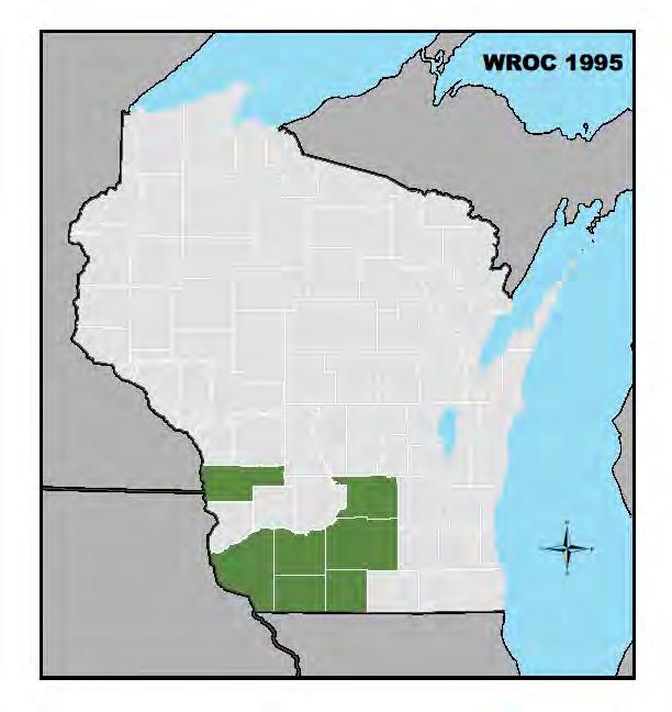

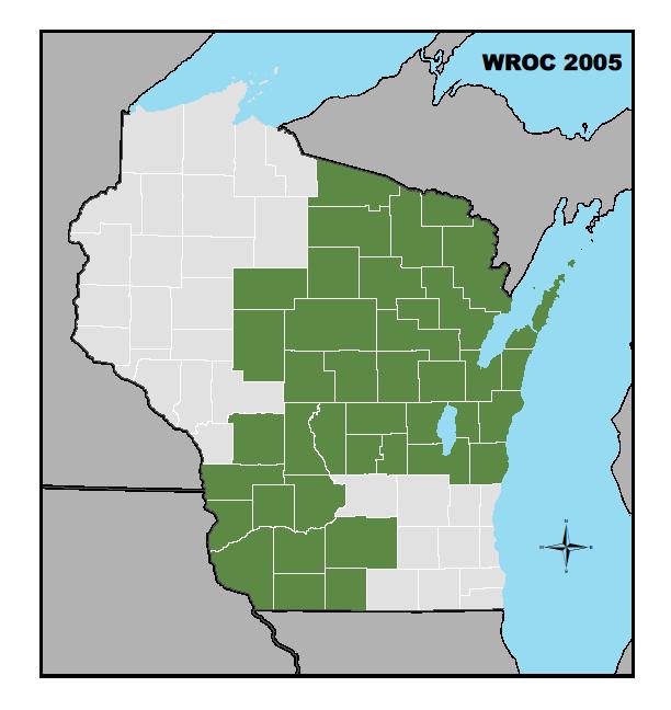
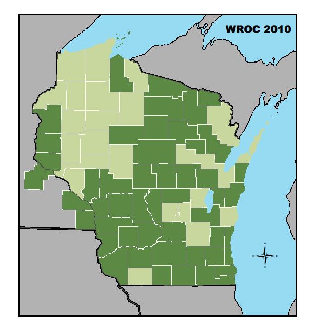
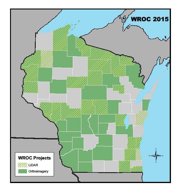
8 WROC Participation History
 orthoimagery is standard deliverable Options for 3-band RGB or CIR as additional deliverable Pixel resolution options: 3-inch")
9 Orthoimagery Project Information Aerial imagery acquired with the most advanced digital mapping cameras for large area collections Aerial imagery flown with ABGPS/IMU Ground control survey included in project Surface model editing included in project 4-band (RGB-NIR) orthoimagery is standard deliverable Options for 3-band RGB or CIR as additional deliverable Pixel resolution options: 3-inch pixel resolution, 1 = 50 map scale 6-inch pixel resolution, 1 = 100 map scale 12-inch pixel resolution, 1 = 200 map scale


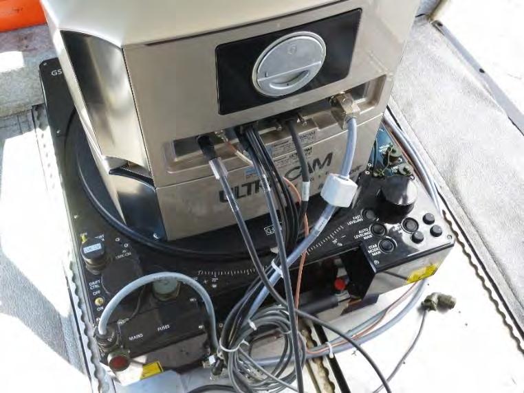
10 Aircraft and Sensor Resources

11 Orthoimagery Specifications and Deliverables Specifications: Leaf-off spring conditions Sun angle is greater than 30 degrees Cloud-free, haze-free, snow-free Orthos meet or exceed stringent ASPRS standards for Class II horizontal accuracy Deliverables: GeoTIFF tiles, uncompressed SID tiles, compressed SID mosaics, compressed Tile index Ground control data Metadata
12 Orthoimagery Fees Budget Pricing: not-to-exceed Pixel Resolution Area (sq mi) 3-inch 6-inch 12-inch $ $550 $ $350 $200 Countywide $250 $80 $55 Unit prices apply to contiguous areas only For projects in the shaded areas, please contact a WROC representative


13 Additional Products and Services Topographic mapping LiDAR LiDAR data extraction Planimetric mapping 2D building outlines Hydro network mapping Utility asset mapping Tree canopy delineation


14 Additional Products and Services LiDAR Light Detection And Ranging: Similar to radar or sonar but using an optical source a laser instead of microwaves or sound waves Applications Floodplain and hazard mapping Drainage studies Feature extraction Terrain analysis Vegetation analysis Engineering planning/design Zoning


15 LiDAR Data Products Bare Earth DEM Classified Point Cloud Hydro Breaklines 1 or 2-ft Contours

16 Wisconsin Countywide LiDAR Recent History 31 counties have completed LiDAR projects Roughly 22,000 square miles collected Recent Funding Partner 3DEP 3D Elevation Program First Applications in 2015 USGS competitive grant WROC/DOA joint application 22 counties have already worked within this program Nearly $1.5 million in grant funds 2018 Status 10 counties are working on LiDAR through WROC and DOA If the grant is successful, Wisconsin will have complete LiDAR coverage


17 Municipal Products and Services Upgrade to 6-inch or 3-inch orthoimagery High density LiDAR (>2 ppm) Planimetric and topographic mapping 1-foot or 2-foot contours Buildings Utility assets Road edges, curb and gutter Impervious surfaces Vegetation

18 WROC Program Update Previous consortium success has built foundation for 2020 As big or bigger than previous round 50+ county members Increased participation from more urban areas in the state Increased partner participation Consortium continues to evolve, build into the future

19 WROC 2020 Participation Timeframe Three-year window for member participation Projects already planned for next year Majority of participation occurring in 2020 Partner datasets draw from member projects completed over three-year span


20 WROC Member Update Projected participation map of

21 WROC Partner Update Utilities Increased participation expected in 2020 High resolution imagery is important for land base, facilities, assets Multiple proposals already submitted and in process for 2020 State and federal agencies Initial meeting held with SAGIC Partner information submitted including specific products and costs for 2020

22 WROC Partner Update (continued) Municipalities Continued interest in supporting countywide projects 3-inch pixel resolution costs have come down substantially Significant interest in 3-inch buy-ups Opens door for highly detailed feature extraction and measurements from aerial imagery Tribes Meet or exceed previous participation levels

 3.")
 summer prior to")
23 How to Participate for Members Next steps: 1. Contact your WROC representative 2. Decide on product specifications (ie: pixel resolution) 3. Budget accordingly (WLIP, CIP, other sources) 4. Sign Letter of Intent (LOI) summer prior to flight year 5. Contract with Ayres in fall prior to flight year
24 How to Participate for Partners Next steps: 1. Contact WROC representative to discuss partnership interest Provide shapefiles of your territories/service areas Determine specific product needs, coordinate systems, formats WROC reps will develop a partnership proposal 2. Confirm partner participation with a Letter of Intent (LOI) Ongoing, beginning now to include multiple budget years 3. Contract with Ayres or North Central Wisconsin RPC Ongoing, beginning now to include multiple budget years
25 Additional Resources WROC 2020 website is now live o Contact your WROC Representative Join LinkedIn group to receive updates WROC
26 WROC Representatives Andy Faust, GISP North Central Wisconsin Regional Planning Commission P: Zach Nienow, GISP Ayres Associates P: Adam Derringer, GISP Ayres Associates P:
27 Question and Answer Session Type questions here How do I sign up for WROC?

28 Additional Samples

29 Additional Samples

30 Additional Samples
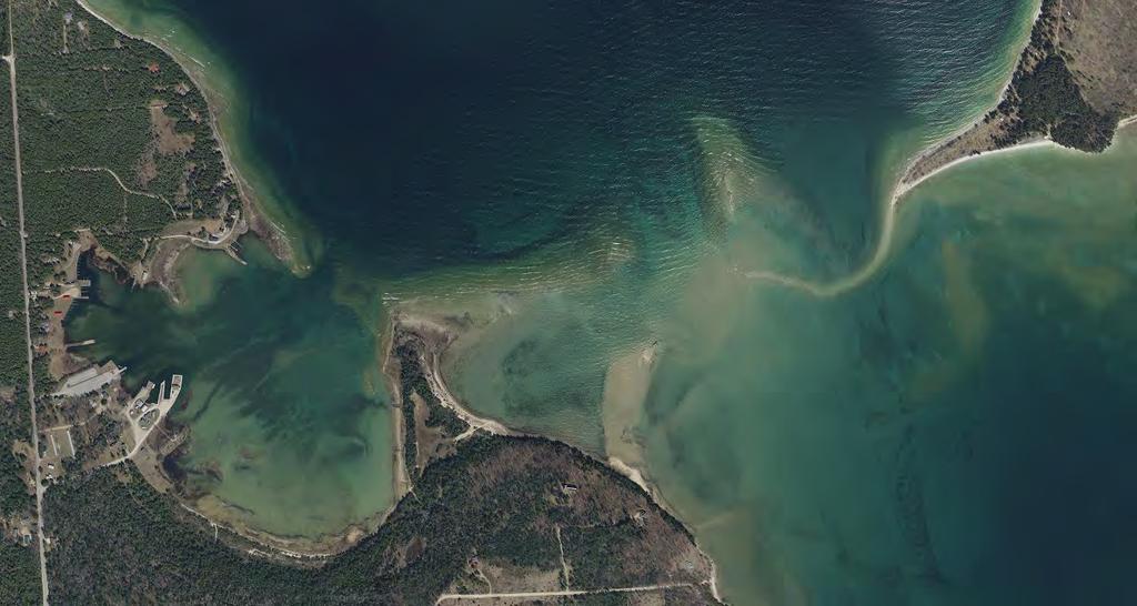
31 Additional Samples

32 Additional Samples
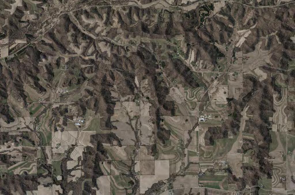
33 Additional Samples
Purdue Road School 2016
 Purdue Road School 2016 Funding has been secured for the first year of a three year update cycle of Indiana s statewide orthoimagery. 2018 2016 2017 We are optimistic that funding will be available for
The PAMAP Program Ortho and LiDAR GIS-T 2008 Houston, TX Special thanks for to Helen Delano & Chris Markel, BAE Systems
 The PAMAP Program Ortho and LiDAR GIS-T 2008 Houston, TX Special thanks for to Helen Delano & Chris Markel, BAE Systems 0 Agenda PA Map Program Ortho-photography LiDAR (Light Detection and Ranging) Cool
Hampshire, Hardy & Morgan Counties WV 2018 Aerial Photography Request for Proposal 2018 Digital Orthophotography
 Hampshire, Hardy & Morgan Counties WV 2018 Aerial Photography Request for Proposal 2018 Digital Orthophotography 1. RFP Purpose Hampshire County, Hardy County and Morgan County WV are seeking proposals
Meeting Date: Agenda Item No:
 Meeting Date: Agenda Item No: Kitsap County Board of Commissioners Office/Department: Information Services Staff Contact: Chad Dean, MS-21, 337-4709 Agenda Item Title: Cooperative Purchasing Agreement
REQUEST FOR PROPOSALS for the Development of Sidewalk Inventory for the DVRPC Region
 REQUEST FOR PROPOSALS for the Development of Sidewalk Inventory for the DVRPC Region To assist with planning efforts to help communities in the region become more pedestrianfriendly and accessible, and
3D Elevation Program (3DEP)
") + 3D Elevation Program (3DEP) GIS-T Jim Langtry USGS National Map Liaison for Nebraska, Iowa, & Kansas April 20, 2015 + 2 3D Elevation Program (3DEP) Applies groundbreaking lidar technology to acquire
+ 3D Elevation Program (3DEP) GIS-T Jim Langtry USGS National Map Liaison for Nebraska, Iowa, & Kansas April 20, 2015 + 2 3D Elevation Program (3DEP) Applies groundbreaking lidar technology to acquire
WHITMAN COUNTY, STATE OF WASHINTON NOTICE TO PROFESSIONAL SERVICES CONSULTANTS FOR
 Administration/Engineering Road Maintenance Equipment Rental & Revolving Solid Waste Division Planning Division Building & Development WHITMAN COUNTY Department of Public Works Mailing Address: P.O. Box
SAR Sensors Acquisition Geometries The Interferometric Concept
 SAR Sensors Acquisition Geometries The Interferometric Concept Fabrizio Novali Tele-Rilevamento Europa Thursday, 2 December 2010 COPYRIGHT - Tele-Rilevamento Europa 2010 Copyright - Tele-Rilevamento Europa
MOBILE ASSET DATA COLLECTION. Pavement Condition Index Ground Penetrating Radar Deflection Testing. Contact Information:
 City of Mercer Island MOBILE ASSET DATA COLLECTION: Pavement Condition Index Ground Penetrating Radar Deflection Testing Contact Information: Leah Llamas, GIS Analyst The City of Mercer Island 9611 SE
HOW MUCH REMOTE SITUATIONAL UNDERSTANDING IS ACHIEVABLE IN THE TIME FRAME?
 Chapter Two HOW MUCH REMOTE SITUATIONAL UNDERSTANDING IS ACHIEVABLE IN THE 2015 2020 TIME FRAME? As mentioned earlier, the first question posed by the ASB asked about the level of intelligence or situational
City of Oakland Park
 Funded Through: DEP AGREEMENT NO. CM238 Working Towards Resilient Coastal Communities City of Oakland Park Vulnerability to Sea Level Rise Assessment Report Prepared on: May 14 This page has been left
Optical, Geospatial, Radar and Elevation Supplies and Services Panel (OGRE)
") Optical, Geospatial, Radar and Elevation Supplies and Services Panel (OGRE) Annual Report 2011 2012 DEPARTMENT OF RESOURCES, ENERGY AND TOURISM Minister for Resources and Energy: The Hon. Martin Ferguson,
Optical, Geospatial, Radar and Elevation Supplies and Services Panel (OGRE) Annual Report 2011 2012 DEPARTMENT OF RESOURCES, ENERGY AND TOURISM Minister for Resources and Energy: The Hon. Martin Ferguson,
UNCLASSIFIED. R-1 Program Element (Number/Name) PE F / Distributed Common Ground/Surface Systems. Prior Years FY 2013 FY 2014 FY 2015
 PE F / Distributed Common Ground/Surface Systems. Prior Years FY 2013 FY 2014 FY 2015") Exhibit R-2, RDT&E Budget Item Justification: PB 2015 Air Force Date: March 2014 3600: Research, Development, Test & Evaluation, Air Force / BA 7: Operational Systems Development COST ($ in Millions) Prior
Exhibit R-2, RDT&E Budget Item Justification: PB 2015 Air Force Date: March 2014 3600: Research, Development, Test & Evaluation, Air Force / BA 7: Operational Systems Development COST ($ in Millions) Prior
North Carolina Geographic Information Coordinating Council
 North Carolina Geographic Information Coordinating Council 2011 Annual Report to the Governor and the North Carolina General Assembly September 2011 Submitted to: Governor Beverly E. Perdue and The Joint
Request for Quotes (RFQ) for Quality Assurance & Quality Control Services for Photogrammetric Base Map Update
 for Quality Assurance & Quality Control Services for Photogrammetric Base Map Update") . GIS Manager 305 Michaelian Office Building White Plains, NY 10601 Request for Quotes (RFQ) for Quality Assurance & Quality Control Services for Photogrammetric Base Map Update Westchester County, New
. GIS Manager 305 Michaelian Office Building White Plains, NY 10601 Request for Quotes (RFQ) for Quality Assurance & Quality Control Services for Photogrammetric Base Map Update Westchester County, New
Request for Solutions: Distributed Live Virtual Constructive (dlvc) Prototype
 Prototype") 1.0 Purpose Request for Solutions: Distributed Live Virtual Constructive (dlvc) Prototype This Request for Solutions is seeking a demonstratable system that balances computer processing for modeling and
1.0 Purpose Request for Solutions: Distributed Live Virtual Constructive (dlvc) Prototype This Request for Solutions is seeking a demonstratable system that balances computer processing for modeling and
Section 6: Coordinating Local Planning
 Section 6: Coordinating Local Planning What s new (summary of updated information) Tables indicating the membership in the Mitigation Core Team and the State Hazard Mitigation Team have been streamlined
STATUS OF REVIEW: ENGINEER ACKNOWLEDGED INFO COMMENT
 PROJECT NAME: SOUTHERN PIG AND CATTLE COMPANY PROJECT NUMBER: 2011050008 APPLICATION: MAJOR SITE PLAN #14999 Met with staff 12/11/14, DRC on 12/15/14 1. DEPARTMENT: ENGDRN - STORMWATER REVIEW REVIEW ITEM:
Apache Fire Control LM MFC Supplier Summit TM
 Apache Fire Control 2015 LM MFC Supplier Summit LOCKHEED CLEARED MARTIN FOR PROPRIETARY PUBLIC RELEASE INFORMATION TM1409-0107-1 Apache Fire Control Programs LONGBOW Fire Control Radar (FCR) Mast Mounted
GENESEE COUNTY SOIL AND WATER CONSERVATION DISTRICT. Organizational Chart
 GENESEE COUNTY SOIL AND WATER CONSERVATION DISTRICT Organizational Chart SWCD Special Purpose District created by local law according to state law USDA NRCS NRCS-Staff Implement programs according to Federal
Facilities Condition Assessment
 Facilities Condition Assessment (O&M 16 018) Date Issued: January 29, 2016 Date Due: Contact: March 3, 2016 at 4:00:00 pm Paul Acosta, Program Manager III paul.acosta@stocktonca.gov City of Stockton Public
snapshots of 17 key Air Force space programs experiments, development, production, sustainment, and upgrades. The list is not allinclusive.
 Snapshots of Space M D ata sheets that follow are snapshots of 17 key Air Force space programs experiments, development, production, sustainment, and upgrades. The list is not allinclusive. It is based
Structural Flood Mitigation
 Community Emergency Preparedness Fund Structural Flood Mitigation 1. Introduction 2018 Program & Application Guide The Community Emergency Preparedness Fund (CEPF) is a suite of funding programs intended
NEW YORK STATE FLOOD MAPPING PROGRAM FY 2004 BUSINESS PLAN
 NEW YORK STATE FLOOD MAPPING PROGRAM EXECUTIVE SUMMARY I. Introduction This business plan, prepared by the State of New York for the Federal Emergency Management Agency (FEMA), describes how the New York
PA 22 Committee February 25, 2016
 PA 22 Committee February 25, 2016 Recommendation Approve amending the PA22 Committee Budget to move $860,120 from the Aerial Mapping Project to the Conservation Based Rates Project. Funding Available Savings
Historical Imagery Digitization Data Project
 Historical Imagery Digitization Data Project Solicitation Number: HM1582-11-ACT-SN0001 Agency: Other Defense Agencies Office: National Geospatial-Intelligence Agency Location: Acquisition Technology (ACT)
MASTERING THE LOGISTICS OF A LARGE SCALE HAZUS PROJECT
 August 25, 2010 MASTERING THE LOGISTICS OF A LARGE SCALE HAZUS PROJECT Shanna Michael, CFM, AECOM Stefan Zink, CFM, Michael Baker Jr., Inc. Agenda Part 1: Project Overview Averaged Annualized Loss Estimation
City of Puyallup City-Owned Fiber Infrastructure Evaluation Project
 REQUEST FOR PROPOSALS City of Puyallup City-Owned Fiber Infrastructure Evaluation Project Due Date: Friday, September 29, 2017; No later than 4:00 PM City of Puyallup 333 S Meridian Puyallup, WA 98371
I. Introduction. II. Goals of the Program
 2017 Chesapeake Bay Trust- Anne Arundel County Watershed Restoration Grant Program Application Package www.chesapeakebaytrust.org / 410-974-2941 I. Introduction The Watershed Restoration Grant Program
Title 5: ADMINISTRATIVE PROCEDURES AND SERVICES
 Title 5: ADMINISTRATIVE PROCEDURES AND SERVICES Chapter 163: OFFICE OF INFORMATION TECHNOLOGY Table of Contents Part 4. FINANCE... Subchapter 1. CHIEF INFORMATION OFFICER... 3 Section 1971. CHIEF INFORMATION
Discharges Associated with Pesticide Applications Under the NPDES Permit Program. Frequently Asked Questions (FAQ)
") Bureau of Point and Non-Point Source Management Discharges Associated with Pesticide Applications Under the NPDES Permit Program Frequently Asked Questions (FAQ) Background On October 29, 2011, the Pennsylvania
Bureau of Point and Non-Point Source Management Discharges Associated with Pesticide Applications Under the NPDES Permit Program Frequently Asked Questions (FAQ) Background On October 29, 2011, the Pennsylvania
UNCLASSIFIED FY 2016 OCO. FY 2016 Base
 Exhibit R-2, RDT&E Budget Item Justification: PB 2016 Air Force Date: February 2015 3600: Research,, Test & Evaluation, Air Force / BA 6: RDT&E Management Support COST ($ in Millions) Prior Years FY 2014
F-35 Lightning II A New Generation of Fighter
 F-35 Lightning II A New Generation of Fighter 1 The Next Generation in Fighter Aircraft A Quantum Leap in Capability LO Treatments Advanced Avionics Guided Weapons First Jets Supersonic First Radar Multirole
Air Defense System Solutions.
 Air Defense System Solutions www.aselsan.com.tr ADSS AIR DEFENSE SYSTEM SOLUTIONS AIR DEFENSE SYSTEM SOLUTIONS Effective air defense is based on integration and coordinated use of airborne and/or ground
Solar Electricity For Community Buildings Pilot Program. Workbook
 Solar Electricity For Community Buildings Pilot Program Workbook Index What is the Solar Electricity for Community Buildings Pilot Program? An Overview 1 How to use this workbook 2 Section 1 Are you eligible
MEMORANDUM. Governor John Hickenlooper & Members of the Colorado General Assembly
 690 Kipling Street, Suite 3000 Lakewood, CO 80215 MEMORANDUM TO: FROM: Governor John Hickenlooper & Members of the Colorado General Assembly Paul L. Cooke, Director DATE: April 28, 2015 RE: 2015 Wildfire
Developing a Tactical Geospatial Course for Army Engineers. By Jared L. Ware
 Developing a Tactical Geospatial Course for Army Engineers By Jared L. Ware ESRI technology, such as the templates, gives the Army an easy-to-use, technical advantage that helps Soldiers optimize GEOINT
Headquarters, Department of the Army
 ATP 3-34.80 GEOSPATIAL ENGINEERING FEBRUARY 2017 DISTRIBUTION RESTRICTION: Approved for public release; distribution is unlimited. This publication supersedes ATP 3-34.80, dated 23 June 2014. Headquarters,
Enterprise GIS Steering Committee (EGIS) Meeting Minutes October 6, 2011
 Meeting Minutes October 6, 2011") I. Call to Order The EGIS Steering Committee meeting was called to order at 1:32 pm on 10/6/2011 in the BTS Conference Room 330, Clearwater Annex building 3 rd Floor. II. Attendance Business Technology
I. Call to Order The EGIS Steering Committee meeting was called to order at 1:32 pm on 10/6/2011 in the BTS Conference Room 330, Clearwater Annex building 3 rd Floor. II. Attendance Business Technology
TRANSPORTATION FUNDING PROGRAMS
 APPENDIX A Note: Not yet edited by DCPD. TRANSPORTATION FUNDING PROGRAMS 6 Transportation Funding Programs The following provides a brief description of transportation related funding programs that are
Major in FY2013/2014 (By and ing Source) Municipal Building Acquisition and Operations Balance $1,984, Contributions from Real Estate
 Municipal Building Acquisition and Operations Balance $1,984, Contributions from Real Estate") Major in FY2013/2014 (By and ing Source) Environmental Services Solid Waste 4200 4200 06CON 4200 SWM01 Balance $13,753,504.00 Balance $4,631,754.00 Balance $2,738,918.00 ing Source Total: $21,124,176.00
Major in FY2013/2014 (By and ing Source) Environmental Services Solid Waste 4200 4200 06CON 4200 SWM01 Balance $13,753,504.00 Balance $4,631,754.00 Balance $2,738,918.00 ing Source Total: $21,124,176.00
King County Flood Control District 2017 Work Program
 Attachment A 2017 Budget Work Program November 7, 2016 FCD2016-20 Attach A King County Flood Control District 2017 Work Program The District work program is comprised of three categories: district oversight
UNMANNED AIRCRAFT SYSTEMS CORRIDOR STUDY
 Scope of Work The Joint Land Use Study Implementation (JLUS) will be a series of projects that will address the recommendations in the Fort Riley Joint Land Use Study. The corridor between Fort Riley Army
Transportation Infrastructure
 Transportation Infrastructure ASSET INVENTORY SERVICES RFQ# 016-0-2015/RS TRTP47007.15 Sumter County Board of County Commissioners RFQ #016-0-2015/RS Name of Firm, Entity or Organization: PART 4 QUALIFICATION
Training Area Management. (ITAM) Program Training Support and the Environment
 Program Training Support and the Environment") Army Sustainable Range Program (SRP) US Army Europe Integrated Training Area Management (ITAM) Program Training Support and the Environment Jeff Andrews USAREUR ITAM Operations Coordinator Jeffrey.a.andrews@us.army.mil
Army Sustainable Range Program (SRP) US Army Europe Integrated Training Area Management (ITAM) Program Training Support and the Environment Jeff Andrews USAREUR ITAM Operations Coordinator Jeffrey.a.andrews@us.army.mil
UNCLASSIFIED. UNCLASSIFIED Air Force Page 1 of 8 R-1 Line #86
 Exhibit R-2, RDT&E Budget Item Justification: PB 2017 Air Force : February 2016 3600: Research, Development, Test & Evaluation, Air Force / BA 5: System Development & Demonstration (SDD) COST ($ in Millions)
House Bill 4023 Ordered by the House February 27 Including House Amendments dated February 15 and February 27
 th OREGON LEGISLATIVE ASSEMBLY--0 Regular Session B-Engrossed House Bill 0 Ordered by the House February Including House Amendments dated February and February Introduced and printed pursuant to House
The City of Mercer Island MOBILE ASSET DATA COLLECTION
 The City of Mercer Island MOBILE ASSET DATA COLLECTION Contact Information: The City of Mercer Island ATTN: Jesse Langdon, GIS Coordinator 9611 SE 36th St Mercer Island, WA 98040 206-275-7771 jesse.langdon@mercergov.org
VALUE ENGINEERING PROGRAM
 Approved: Effective: May 17, 2017 Review: March 30, 2017 Office: Production Support Office Topic No.: 625-030-002-i Department of Transportation PURPOSE: VALUE ENGINEERING PROGRAM To provide a consistent
Geographic Intelligence
 MCWP 2-12.1 Geographic Intelligence U.S. Marine Corps 6 July 2000 PCN 143 000067 00 DEPARTMENT OF THE NAVY Headquarters United States Marine Corps Washington, DC 20380-1775 6 July 2000 FOREWORD Marine
Director, Intelligence and Security Research Center George Mason University
 Maj Gen (Ret) Robert H. Latiff, USAF Director, Intelligence and Security Research Center George Mason University Introduction and Personal History Work I ve Done and How It Related Research and Development
UNCLASSIFIED. Cost To Complete Total Program Element Continuing Continuing : OC-135 Open Skies Sensors
 Exhibit R-2, RDT&E Budget Item Justification: PB 2016 Air Force : February 2015 3600: Research, Development, Test & Evaluation, Air Force / BA 7: Operational Systems Development COST ($ in Millions) Years
Military Radar Applications
 Military Radar Applications The Concept of the Operational Military Radar The need arises during the times of the hostilities on the tactical, operational and strategic levels. General importance defensive
F-16 Fighting Falcon The Most Technologically Advanced 4th Generation Fighter in the World
 F-16 Fighting Falcon The Most Technologically Advanced 4th Generation Fighter in the World Any Mission, Any Time... the F-16 Defines Multirole The enemies of world peace are changing. The threats are smaller,
DRCOG Data Consortium. March 2015
 DRCOG Data Consortium March 2015 Agenda Introductions Report on DRCOG s 2015 Data Request and Data Portal Creating a Regional Zoning Map Clean QCEW Data Planimetric Data Discussion Strava Data Discussion
Spanish Maritime Safety Agency
 Spanish Maritime Safety Agency 1 2012 Index Spanish Maritime Administration Spanish Maritime Safety Agency. Scope of action. 2011 Activities SASEMAR Headquarters and MRCCs SASEMAR Resources Jovellanos
Proper organization of the. Can the Modular Engineer Battalion Headquarters Be Multifunctional?
 Can the Modular Engineer Battalion Headquarters Be Multifunctional? By Major William C. Hannan The 5th Engineer Battalion received its deployment order for Operation Iraqi Freedom late in 2007 and deployed
UNCLASSIFIED R-1 ITEM NOMENCLATURE
 Exhibit R-2, RDT&E Budget Item Justification: PB 2013 Air Force DATE: February 2012 Program Element 16.104 48.666 19.004-19.004 19.950 31.056 31.181 31.730 Continuing Continuing 633150: Advanced Optics
Using Aircraft-based Radar for Monitoring Critical Water Infrastructure
 Using Aircraft-based Radar for Monitoring Critical Water Infrastructure Cathleen E. Jones Jet Propulsion Laboratory, California Institute of Technology DWR / NWRI / SCSC 2016 Drought Response Workshop.
UNCLASSIFIED. R-1 ITEM NOMENCLATURE PE A: Landmine Warfare and Barrier Advanced Technology FY 2012 OCO
 Exhibit R-2, RDT&E Budget Item Justification: PB 2012 Army DATE: February 2011 COST ($ in Millions) FY 2010 FY 2011 Base OCO Total FY 2013 FY 2014 FY 2015 FY 2016 Cost To Complete Total Cost Total Program
UNCLASSIFIED. COST ($ in Millions) FY 2008 FY 2009 FY 2010 FY 2011 FY 2012 FY 2013 FY 2014 FY 2015
 FY 2008 FY 2009 FY 2010 FY 2011 FY 2012 FY 2013 FY 2014 FY 2015") EXHIBIT R-2, RDT&E Budget Item Justification APPROPRIATION/BUDGET ACTIVITY RESEARCH DEVELOPMENT TEST & EVALUATION, NAVY / BA-7 R-1 ITEM NOMENCLATURE 0305160N NAVY METEOROLOGICAL & OCEAN SENSORS-SPACE (METOC)
EXHIBIT R-2, RDT&E Budget Item Justification APPROPRIATION/BUDGET ACTIVITY RESEARCH DEVELOPMENT TEST & EVALUATION, NAVY / BA-7 R-1 ITEM NOMENCLATURE 0305160N NAVY METEOROLOGICAL & OCEAN SENSORS-SPACE (METOC)
BOROUGH OF STONE HARBOR CRS ACTIVITY 510. Progress Report on Hazard Mitigation Initiatives
 BOROUGH OF STONE HARBOR CRS ACTIVITY 510 Progress Report on Hazard Initiatives of Stone Harbor Hazard Plan Adopted: By Resolution 2016 S-125 3 Year CRS Expiration Date: A copy of the adopted plan can be
Proposals for Logan Square
 Proposals for Logan Square Table 1 Table 2 (Proposal A) Farmers market 54 56,760 sq.ft. s For residents No restaurants 17 18,480 sq.ft. 50 s, surface 80 s, surface Total acquisition and development costs:
Study on Copernicus Sentinels Products Economic Value
 Study on Copernicus Sentinels Products Economic Value Alessandra Tassa Earth Observation Programmes Directorate European Space Agency Workshop: Exploiting the value in EO data Geospatial World Forum 26
2:00 p.m. on Monday, August 11, 2014
 SAN DIEGUITO RIVER PARK JOINT POWERS AUTHORITY REQUEST FOR PROPOSAL TO PREPARE A FEASIBILITY STUDY FOR A TRAIL BRIDGE OVER THE SAN DIEGUITO RIVER (POLO/MORGAN RUN) I. INVITATION You are invited to submit
CFA Orphan or Abandoned Well Plugging (OAWP) Program Information for Potential CFA OAWP Grant Applicants
 Program Information for Potential CFA OAWP Grant Applicants") CFA Orphan or Abandoned Well Plugging (OAWP) Program 2018 Information for Potential CFA OAWP Grant Applicants CFA OAWP Program Summary Grant source: Act 13 Marcellus Legacy Fund Eligible projects: well
CFA Orphan or Abandoned Well Plugging (OAWP) Program 2018 Information for Potential CFA OAWP Grant Applicants CFA OAWP Program Summary Grant source: Act 13 Marcellus Legacy Fund Eligible projects: well
2 Description of the Proposed Action and Alternatives
 2 Description of the Proposed Action and Alternatives 2.1 Proposed Action The DON proposes to transition the Expeditionary VAQ squadrons at NAS Whidbey Island from the EA-6B Prowler to the EA-18G Growler
UNCLASSIFIED. UNCLASSIFIED Navy Page 1 of 7 R-1 Line #16
 Exhibit R-2, RDT&E Budget Item Justification: PB 2015 Navy Date: March 2014 1319: Research, Development, Test & Evaluation, Navy / BA 3: Advanced Development (ATD) COST ($ in Millions) Prior Years FY 2013
REQUEST FOR QUOTATIONS
 REQUEST FOR QUOTATIONS Professional Surveying Services for the Record Plan Survey of Project Area of KWA Contracts S-4005, S-4006 S-4007 and GCDC-WWS Contract S-5004 Issuing Agency: Lapeer County Road
Exhibit R-2, RDT&E Budget Item Justification
 PE NUMBER: 0603500F PE TITLE: MULTI-DISCIPLINARY ADV Exhibit R-2, RDT&E Budget Item Justification BUDGET ACTIVITY PE NUMBER AND TITLE Cost ($ in Millions) FY 2006 FY 2007 FY 2008 FY 2009 FY 2010 FY 2011
F-35 Lightning II EOTS Lockheed Martin Missiles and Fire Control 2015 Supplier Summit TM
 F-35 Lightning II EOTS Lockheed Martin Missiles and Fire Control 2015 Supplier Summit LOCKHEED CLEARED MARTIN FOR PROPRIETARY PUBLIC RELEASE INFORMATION TM1409-0107-1 F-35 Lightning II Electro-Optical
COMPLIANCE AND IMPLEMENTATION OF THE TREATY ON OPEN SKIES
 DEPARTMENTO):"THE NAVY OFFICE OF THE SECRETARY 1000 NAVY PENTAGON WASHINGTON, D.C. 20350-1000 SECNAVINST 5710.26 SSP/NTIP March 4, 2003 SECNAV INSTRUCTION 5710.26 From: To: Subj: Secretary of the Navy
Mississippi State University
 The Role of Mississippi State University in Helping to Grow the State s Economy Economic Impact of Research The Role of Mississippi State University in Helping to Grow the State s Economy The role of
A udit R eport. Office of the Inspector General Department of Defense. Report No. D October 31, 2001
 A udit R eport ACQUISITION OF THE FIREFINDER (AN/TPQ-47) RADAR Report No. D-2002-012 October 31, 2001 Office of the Inspector General Department of Defense Report Documentation Page Report Date 31Oct2001
A Field Operations Resource Guide
 CIVIL AIR PATROL CAPABILITIES HANDBOOK A Field Operations Resource Guide REVISED AND UPDATED JUNE 2008 CIVIL AIR PATROL CAPABILITIES HANDBOOK PAGE i INTRODUCTION The Civil Air Patrol (CAP) is a national
Introduction RESPONSIBILITIES
 Introduction Throughout history, the knowledge and physical effects of terrain have played a dominant role in the development of society during both peace and war. Terrain is a portion of the earth s surface
CHAPTER 3 ENVIRONMENTAL EFFECTS ON OPERATIONS
 CHAPTER 3 ENVIRONMENTAL EFFECTS ON OPERATIONS Weather information is critical to aviation planning. Aviation commanders and staffs must have current weather forecasts and observations throughout the entire
Integration of Topographic Engineering Skills and Tools
 Integration of Topographic Engineering Skills and Tools Providing Assured Mobility With C2 Systems By Mr. Ken Bergman Officer career-level topographic engineering instruction at the Engineer School incorporates
AGI Technology for EW and AD Dominance
 AGI Technology for EW and AD Dominance Singapore 2015 Content Overview of Air Defense Overview of Electronic Warfare A practical example Value proposition Summary AMD - a multidisciplinary challenge Geography
Army Geospatial Guide for Commanders and Planners
 Army Geospatial Guide for Commanders and Planners HEADQUARTERS, DEPARTMENT OF THE ARMY NOVEMBER 2003 DISTRIBUTION RESTRICTION: Approved for public release; distribution is unlimited. *TC 5-230 Training
NOAA s Commercial Remote Sensing Regulatory Affairs
 NOAA s Commercial Remote Sensing Regulatory Affairs What is CRSRA? Current Authorities Who do we work with? What do we do? Licensing Compliance ACCRES Agenda Improving the Regulatory Process Staff Information
Littoral OpTech-West. Panel 4: Seeing Through the Clutter: On the Surface & Over the Shore
 Littoral OpTech-West Panel 4: Seeing Through the Clutter: On the Surface & Over the Shore Experience of the Sea Giraffe in the USN The requirements for the USN s Littoral Combat Ship created a challenging
PUBLIC LIBRARY CONSTRUCTION GRANTS
 PUBLIC LIBRARY CONSTRUCTION GRANTS GUIDELINES and APPLICATION Application Deadline: April 1, 2015 Florida Department of State Division of Library and Information Services R.A. Gray Building, Tallahassee,
Broad Agency Announcement Geospatial Cloud Analytics (GCA) STRATEGIC TECHNOLOGY OFFICE HR001118S0004
 STRATEGIC TECHNOLOGY OFFICE HR001118S0004") Broad Agency Announcement STRATEGIC TECHNOLOGY OFFICE HR001118S0004 October 11, 2017 TABLE OF CONTENTS HR001118S0004 PART I: OVERVIEW INFORMATION...4 PART II: FULL TEXT OF ANNOUNCEMENT...5 1. FUNDING OPPORTUNITY
Broad Agency Announcement STRATEGIC TECHNOLOGY OFFICE HR001118S0004 October 11, 2017 TABLE OF CONTENTS HR001118S0004 PART I: OVERVIEW INFORMATION...4 PART II: FULL TEXT OF ANNOUNCEMENT...5 1. FUNDING OPPORTUNITY
TESTING APPLICATION STANDARD (TAS) IMPACT TEST PROCEDURES
 IMPACT TEST PROCEDURES") TESTING APPLICATION STANDARD (TAS) 201-94 IMPACT TEST PROCEDURES 1. 2. Scope: 1.1 This protocol covers procedures for conducting the impact test of materials as required by Section 1626 of the Florida
TESTING APPLICATION STANDARD (TAS) 201-94 IMPACT TEST PROCEDURES 1. 2. Scope: 1.1 This protocol covers procedures for conducting the impact test of materials as required by Section 1626 of the Florida
GENESEE COUNTY COMPREHENSIVE PLAN TECHNOLOGY FOCUS GROUP MONITORING REPORT JULY Lead Agency
 TE01 Provide management and labor resources to operate an up-to-date countywide GIS for governmental, commercial, business, industrial, and residential users. Real Property, Legislature The Health Departments
Georgia Environmental Conference
 Georgia Environmental Conference August 23, 2017 Mr. Alvin B. Lee, Director of Programs US Army Corps of Engineers South Atlantic Division Trusted Partners Delivering Value Today for a Better Tomorrow
2015/2016 Small Matching Historic Preservation Online Grant Application
 2015/2016 Small Matching Historic Preservation Online Grant Application Bureau of Historic Preservation Grants Program Division of Historical Resources April 23, 2014, 10:00 a.m. To hear the audio portion
<3& =&, >()$)2&+?$'$4&#&'2 *0+#$2(0' B-$' 60+ <&3+$' C(27 "#$%&'!
$)2&+?$'$4&#&'2 *0+#$2(0' B-$' 60+ <&3+$' C(27 #$%&'!") !"#$%& '()%)*"$ +(*(,%*(-& %&. +%&%,"/"&* 0$,%&(1%*(-& ()$)2&+?$'$4&#&'2 ?
!"#$%& '()%)*"$ +(*(,%*(-& %&. +%&%,"/"&* 0$,%&(1%*(-& ()$)2&+?$'$4&#&'2 ?
RQ-4A GLOBAL HAWK UNMANNED AERIAL VEHICLE (UAV) SYSTEMS
 SYSTEMS") RQ-4A GLOBAL HAWK UNMANNED AERIAL VEHICLE (UAV) SYSTEMS Air Force Program Total Number of Systems Global Hawk Air Vehicles: Common Ground Segments: Total Program Cost (TY$): Average Unit Production Cost
RQ-4A GLOBAL HAWK UNMANNED AERIAL VEHICLE (UAV) SYSTEMS Air Force Program Total Number of Systems Global Hawk Air Vehicles: Common Ground Segments: Total Program Cost (TY$): Average Unit Production Cost
Next Steps to Revolutionary Change of Spectrum Usage
 DoD CIO Next Steps to Revolutionary Change of Spectrum Usage Maj Gen Robert E. Wheeler (Ret) Slide 1 POWER TO THE EDGE Thesis Spectrum is an essential engine for economic strength, driving U.S. leadership
17897 Infantry Platoon Battle Course (IPBC) RANGE DESIGN GUIDE
 RANGE DESIGN GUIDE") 17897 Infantry Platoon Battle Course (IPBC) RANGE DESIGN GUIDE RANGE AND TRAINING LAND PROGRAM MANDATORY CENTER OF EXPERTISE U.S. ARMY ENGINEERING AND SUPPORT CENTER, HUNTSVILLE HUNTSVILLE, ALABAMA 256-895-1534
17897 Infantry Platoon Battle Course (IPBC) RANGE DESIGN GUIDE RANGE AND TRAINING LAND PROGRAM MANDATORY CENTER OF EXPERTISE U.S. ARMY ENGINEERING AND SUPPORT CENTER, HUNTSVILLE HUNTSVILLE, ALABAMA 256-895-1534
ORDINANCE NO. 640 NOW, THEREFORE, BE IT ORDAINED BY THE MAYOR AND CITY COUNCIL OF THE CITY OF FRUITLAND, IDAHO:
 ORDINANCE NO. 640 AN ORDINANCE OF THE CITY OF FRUITLAND, IDAHO, AMENDING TITLE 9, CHAPTER 3, SECTION 2, DRAINAGE STANDARDS; AMENDING TITLE 10, CHAPTER 7A, SECTION 19, STORM DRAINAGE; AMENDING TITLE 10,
SUBMISSION DEADLINE: Thursday, April 5, 2016, 6:00 PM
 2018 AIA Austin Design Awards Call for Entries The AIA Austin Design Awards program recognizes outstanding architecture projects by our members. The Design Awards process recognizes outstanding work completed
UNCLASSIFIED. R-1 Program Element (Number/Name) PE A / Landmine Warfare and Barrier Advanced Technology. Prior Years FY 2013 FY 2014 FY 2015
 PE A / Landmine Warfare and Barrier Advanced Technology. Prior Years FY 2013 FY 2014 FY 2015") Exhibit R-2, RDT&E Budget Item Justification: PB 2015 Army Date: March 2014 2040: Research, Development, Test & Evaluation, Army / BA 3: Advanced Technology Development (ATD) COST ($ in Millions) Prior
Exhibit R-2, RDT&E Budget Item Justification: PB 2015 Army Date: March 2014 2040: Research, Development, Test & Evaluation, Army / BA 3: Advanced Technology Development (ATD) COST ($ in Millions) Prior
IMPROVE THE PLANNING, OPERATION AND MAINTENANCE OF TRANSPORT INFRASTRUCTURES
 TACKLE REAL CHALLENGES BY USING EARTH OBSERVATION TECHNOLOGY IMPROVE THE PLANNING, OPERATION AND MAINTENANCE OF TRANSPORT INFRASTRUCTURES Submit your solution until 30.06.2017 The FabSpace 2.0 project
Flip Your Strip Park Strip Lawn Conversion Program MEMBER AGENCY TURN-KEY WATER CONSERVATION PROGRAM
 Flip Your Strip Park Strip Lawn Conversion Program MEMBER AGENCY TURN-KEY WATER CONSERVATION PROGRAM Member Agency Grant Assistance Background For several years, Jordan Valley Water Conservancy District
Comprehensive Planning Grant. Comprehensive Plan Checklist
 Comprehensive Planning Grant Comprehensive Plan Checklist This form was updated April 2010 Comprehensive Planning Grant Program Department of Administration Division of Intergovernmental Relations 101
November 7, 2013 November 7, To establish an asbestos management program for County facilities and projects.
 TO: FROM: PREPARED BY: SUBJECT: PPM#: ALL COUNTY PERSONNEL ROBERT WEISMAN COUNTY ADMINISTRATOR RISK MANAGEMENT ASBESTOS MANAGEMENT PROGRAM CW-L-010 ISSUE DATE EFFECTIVE DATE November 7, 2013 November 7,
FLORIDA DEPARTMENT OF ENVIRONMENTAL PROTECTION RECREATIONAL TRAILS PROGRAM GRANT PROGRAM GRANT APPLICATION PACKAGE
 FLORIDA DEPARTMENT OF ENVIRONMENTAL PROTECTION RECREATIONAL TRAILS PROGRAM GRANT PROGRAM GRANT APPLICATION PACKAGE INTRODUCTION The Intermodal Surface Transportation Efficiency Act (ISTEA) of 1991 included