SAR Sensors Acquisition Geometries The Interferometric Concept
|
|
|
- Lambert Walsh
- 6 years ago
- Views:
Transcription


1 SAR Sensors Acquisition Geometries The Interferometric Concept Fabrizio Novali Tele-Rilevamento Europa Thursday, 2 December 2010 COPYRIGHT - Tele-Rilevamento Europa 2010 Copyright - Tele-Rilevamento Europa
2 SAR Sensors COPYRIGHT - Tele-Rilevamento Europa
3 Satellite SAR: A Coherent Sensor A synthetic aperture radar (SAR) works Radar satellite R by illuminating the Earth with a beam of coherent microwave radiation such as a laser. Phase information is essential for SAR data processing. X-band 3 cm C-band 6 cm L-band 24 cm Earth COPYRIGHT - Tele-Rilevamento Europa


4 Why Radar Remote Sensing? 1. It s an active system: it does not require external illumination sources (Sun light) like optical systems 2. It operates at microwave frequencies: they can penetrate through the clouds 3. It is a coherent system: it allows to precisely measure changes in the satellite-target distance by means of interferometry COPYRIGHT - Tele-Rilevamento Europa


5 SAR vs. Optical data SAR Multi Image Reflectivity map (MIR) Optical image COPYRIGHT - Tele-Rilevamento Europa


6 Milan COPYRIGHT - Tele-Rilevamento Europa
 ERS 1+2 35 Envisat 35 RADARSAT-1 24 RADARSAT-2 24 COSMO SkyMed 8 TerraSAR-X 11 1992")
7 X-band Resolution C-band What SAR Sensors are Available? Historical Analysis Monitoring Repeat Time (days) ERS Envisat 35 RADARSAT-1 24 RADARSAT-2 24 COSMO SkyMed 8 TerraSAR-X Present Day Future COPYRIGHT - Tele-Rilevamento Europa
8 Geometry of Acquisitions COPYRIGHT - Tele-Rilevamento Europa


9 Acquisition Geometry 7,5 km/s orbit 23 ~ 800 km ground range 100 km azimuth COPYRIGHT - Tele-Rilevamento Europa
10 Descending orbits N Rome S COPYRIGHT - Tele-Rilevamento Europa 2010
11 Ascending orbits N Rome S COPYRIGHT - Tele-Rilevamento Europa 2010
12 Satellite Images Distance from Radar (slant range) H ground range COPYRIGHT - Tele-Rilevamento Europa
13 Ground Range to Slant Range A B C D E F G H I J K L M N O P Ground Range COPYRIGHT - Tele-Rilevamento Europa
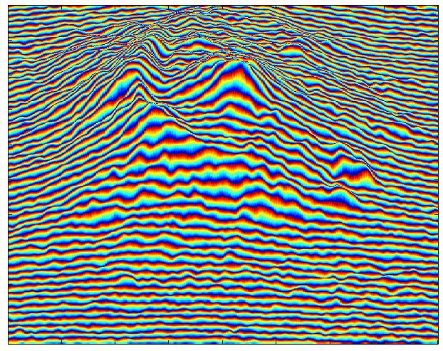
14 Geographic and SAR Coordinates Geographic coordinates SAR coordinates A z i m u t h Slope + Slope - A z i m u t h Slope + Slope - Ground range Slant-range foreshortening COPYRIGHT - Tele-Rilevamento Europa


15 Examples of Geometric Distortions FORESHORTENING LAYOVER, SHADOWING COPYRIGHT - Tele-Rilevamento Europa
16 Interferometric Concept COPYRIGHT - Tele-Rilevamento Europa
17 The Basic Interferometric Principle Satellite passes over an area of interest (AOI) Radar signals are reflected back to the satellite from high reflectivity ground objects The distance from the satellite to the ground object is represented here as R1 R 2 R 1 Ground deformation occurs The satellite re-passes over the same area Reflecting object ΔR The difference between R1 and R2 is the displacement (ΔR) along the satellite line-ofsight (LOS) Ground displacement is measured COPYRIGHT - Tele-Rilevamento Europa

18 InSAR for Displacement Detection The unit of length used in InSAR is the wavelength: R1 R2 R1 R2 DR = c Df Df Interferometry ΔR = 5.66 cm D r R 1 R 2 COPYRIGHT - Tele-Rilevamento Europa


19 SAR Data A SAR image is a set of pixels characterized by both amplitude and phase values Amplitude Phase (known modulo 2p) The phase is related to the sensor-target distance R COPYRIGHT - Tele-Rilevamento Europa

20 Single SAR image: Phase Contributions f 4p r Amplitude Y Reflectivity of the radar target 4pr/ Propagator : it depends on the sensor-radar target distance Atmospheric Phase Contribution Noise Phase COPYRIGHT - Tele-Rilevamento Europa
21 Interferogram: phase contributions If: 4p Df D Dr D noise nothing has changed: D = D = 0 for high SNR: = 0 4p f Dr The interferometric phase is proportional to range variations COPYRIGHT - Tele-Rilevamento Europa
22 Interferogram: Phase Contributions f f flat f elevation f displacement f atmosphere f noise Geometrical and/or temporal decorrelation B n 4p r R tan 4p B n R 0 Dq sin 4p d D COPYRIGHT - Tele-Rilevamento Europa

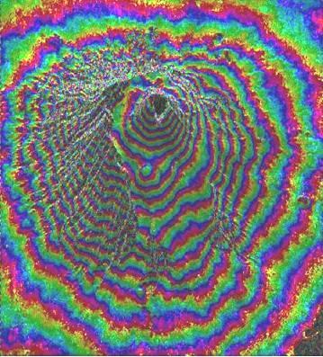
23 InSAR for DEM reconstruction Bn COPYRIGHT - Tele-Rilevamento Europa


24 Differential Interferogram Generation Interferogram - = Synthetic Interferogram generated from a DEM Differential Interferogram Df f ˆ f topo motion DEMerror noise atmosphere COPYRIGHT - Tele-Rilevamento Europa
 became more and more evident")
25 Limits of Conventional DInSAR Analysis Thanks to ESA archive, since 1993 a growing gallery of examples of DInSAR interferometry started being available. While more and more InSAR were generated, the presence of atmospheric artefacts and problems due to phase decorrelation (temporal and/or geometrical) became more and more evident COPYRIGHT - Tele-Rilevamento Europa


26 Limits of Conventional DInSAR Analysis 4p Df D Dr D noise Amplitude data 1-day (Tandem) interferogram D 0 15-months... D 0 COPYRIGHT - Tele-Rilevamento Europa 2010


27 Atmospheric Effects If the propagation medium changes in the time interval between two SAR acquisitions (e.g. humidity, temperature, pressure ), an additive phase term appears. Amplitude data Interferogram COPYRIGHT - Tele-Rilevamento Europa
")


28 Atmospheric Effects Two additive phase term appears: (1) topography dependent (2) due to turbulence phenomena 1-Aug-95 / 2-Apr-96 2-Aug-95 / 3-Apr-96 COPYRIGHT - Tele-Rilevamento Europa


29 Time PSI Understanding Displacement Satellite images are analysed using a multi image approach Images are acquired each time the satellite passes over the same area of ground As interferograms are acquired, they are stacked Consistent PS are identified in the data Individual displacement time-series is calculated for each PS Time-series of PS Stack of interferograms COPYRIGHT - Tele-Rilevamento Europa

30 COPYRIGHT - Tele-Rilevamento Europa

31 Close up on the cemetery COPYRIGHT - Tele-Rilevamento Europa

32 Measurements along the LOS Incidence angles are often very low high sensitivity to vertical displacement θ θ PS PS d PS d real d real d PS COPYRIGHT - Tele-Rilevamento Europa

33 Ascending and Descending: an example Ascending Vert Descending V D >0 East LOS Desce V A <0 LOS Asce COPYRIGHT - Tele-Rilevamento Europa 2010


34 The importance of the reference point All PSI measurements are differential measurements with respect to the reference point COPYRIGHT - Tele-Rilevamento Europa
35 Synoptic Table Advantages Limitations Regular updates over large areas Cost-effective High PS density (up to 1,000 PS/km 2 ) Fast data processing / low user interaction High accuracy Data easily imported in GIS Vegetated and forested areas prevent any PSInSAR data processing. Low-reflectivity areas (e.g. smooth surfaces and certain materials). Temporal sampling limited by satellite repeat-cycles Only slow deformation can be measured (<10 cm/yr in LOS) COPYRIGHT - Tele-Rilevamento Europa
Detecting and Monitoring Ground Movement using Satellite Borne Radar - InSAR
 Detecting and Monitoring Ground Movement using Satellite Borne Radar - InSAR Copyright - Tele-Rilevamento Europa - T.R.E. s.r.l. - 2004 1 What is InSAR? Interferometry Synthetic Aperture Radar Copyright
Statistical analysis of atmospherical components in ERS SAR data
 Statistical analysis of atmospherical components in ERS SAR data A.Ferretti *^, F.Novali ^, E. Passera^, C. Prati*, F.Rocca* FRINGE05 ESRIN Frascati - 2005 (*) Politecnico di Milano (^) Tele-Rilevamento
Using Aircraft-based Radar for Monitoring Critical Water Infrastructure
 Using Aircraft-based Radar for Monitoring Critical Water Infrastructure Cathleen E. Jones Jet Propulsion Laboratory, California Institute of Technology DWR / NWRI / SCSC 2016 Drought Response Workshop.
Exhibit R-2, RDT&E Budget Item Justification
 PE NUMBER: 0603500F PE TITLE: MULTI-DISCIPLINARY ADV Exhibit R-2, RDT&E Budget Item Justification BUDGET ACTIVITY PE NUMBER AND TITLE Cost ($ in Millions) FY 2006 FY 2007 FY 2008 FY 2009 FY 2010 FY 2011
HOW MUCH REMOTE SITUATIONAL UNDERSTANDING IS ACHIEVABLE IN THE TIME FRAME?
 Chapter Two HOW MUCH REMOTE SITUATIONAL UNDERSTANDING IS ACHIEVABLE IN THE 2015 2020 TIME FRAME? As mentioned earlier, the first question posed by the ASB asked about the level of intelligence or situational
WROC. Kickoff Webinar. Thank you for joining us. The webinar will begin shortly. All participant lines are muted.
 Kickoff Webinar WROC 2020 Thank you for joining us. The webinar will begin shortly. All participant lines are muted. Kickoff Webinar WROC 2020 WROC 2020 Kickoff Webinar September 20, 2017 Welcome members,
Study on Copernicus Sentinels Products Economic Value
 Study on Copernicus Sentinels Products Economic Value Alessandra Tassa Earth Observation Programmes Directorate European Space Agency Workshop: Exploiting the value in EO data Geospatial World Forum 26
Naval Earthmap Observer (Nemo) Program
 Program") Naval Earthmap Observer (Nemo) Program Thomas L. Wilson Code 8200 Naval Research Laboratory 4555 Overlook Avenue, SW Washington, DC 20375-5000 phone: (202) 767-0518 fax: (202) 404-2898 e-mail: wilson@ncst.nrl.navy.mil
Naval Earthmap Observer (Nemo) Program Thomas L. Wilson Code 8200 Naval Research Laboratory 4555 Overlook Avenue, SW Washington, DC 20375-5000 phone: (202) 767-0518 fax: (202) 404-2898 e-mail: wilson@ncst.nrl.navy.mil
Technology Development in Support of Port Security. Michael S. Bruno Stevens Institute of Technology July 19, 2012
 Technology Development in Support of Port Security Michael S. Bruno Stevens Institute of Technology July 19, 2012 The National Center for Secure and Resilient Maritime Commerce CSR A Department of Homeland
IMPROVE THE PLANNING, OPERATION AND MAINTENANCE OF TRANSPORT INFRASTRUCTURES
 TACKLE REAL CHALLENGES BY USING EARTH OBSERVATION TECHNOLOGY IMPROVE THE PLANNING, OPERATION AND MAINTENANCE OF TRANSPORT INFRASTRUCTURES Submit your solution until 30.06.2017 The FabSpace 2.0 project
National Polar-Orbiting Operational Environmental Satellite System (NPOESS) - Archived 12/2005
 - Archived 12/2005") C 4 I Forecast National Polar-Orbiting Operational Environmental Satellite System (NPOESS) - Archived 12/2005 Outlook Forecast International projects the U.S. NOAA, U.S. DoD, and NASA will spend some US$5.21
C 4 I Forecast National Polar-Orbiting Operational Environmental Satellite System (NPOESS) - Archived 12/2005 Outlook Forecast International projects the U.S. NOAA, U.S. DoD, and NASA will spend some US$5.21
ESA BIC Lazio Start Up Programme Roberto Giuliani ITech Incubator Manager - BIC Lazio SpA
 CCIC Lazio Region Study Visit ITechIncubator, Rome 25 th November 2013 ESA BIC Lazio Start Up Programme Roberto Giuliani ITech Incubator Manager - BIC Lazio SpA T e c h n i c a l s u p p o r t Topics ESA
NTU collaborates with Nexeya to develop commercial nanosatellites.
 News Release Singapore, 7 th Feb 2018 NTU collaborates with Nexeya to develop commercial nanosatellites. - France and Singapore Year of Innovation 2018 Nanyang Technological University, Singapore (NTU
UNCLASSIFIED. R-1 Program Element (Number/Name) PE N / Navy Meteorological and Ocean Sensors-Space(METOC)
 PE N / Navy Meteorological and Ocean Sensors-Space(METOC)") Exhibit R-2, RDT&E Budget Item Justification: PB 2015 Navy Date: March 2014 1319: Research, Development, Test & Evaluation, Navy / BA 7: Operational Systems Development COST ($ in Millions) Prior Years
Exhibit R-2, RDT&E Budget Item Justification: PB 2015 Navy Date: March 2014 1319: Research, Development, Test & Evaluation, Navy / BA 7: Operational Systems Development COST ($ in Millions) Prior Years
Military Radar Applications
 Military Radar Applications The Concept of the Operational Military Radar The need arises during the times of the hostilities on the tactical, operational and strategic levels. General importance defensive
Ballistic Missile Defense Guidance and Control Issues
 Science & Global Security, 1998, Volume 8, pp. 99-124 Reprints available directly from the publisher Photocopying permitted by license only 1998 OPA (Overseas Publishers Association) Amsterdam B.V. Published
UNCLASSIFIED. FY 2016 Base FY 2016 OCO
 Exhibit R-2, RDT&E Budget Item Justification: PB 2016 Navy : February 2015 1319: Research, Development, Test & Evaluation, Navy / BA 7: Operational Systems Development COST ($ in Millions) Years FY 2014
snapshots of 17 key Air Force space programs experiments, development, production, sustainment, and upgrades. The list is not allinclusive.
 Snapshots of Space M D ata sheets that follow are snapshots of 17 key Air Force space programs experiments, development, production, sustainment, and upgrades. The list is not allinclusive. It is based
Basic Guidelines for Space Development and Use of Space
 Basic Guidelines for Space Development and Use of Space January 15, 2009 Committee on Promotion of Space Development and Use Ministry of Defense of Japan Table of Contents I. Trends of Space Development
ARMY RDT&E BUDGET ITEM JUSTIFICATION (R2 Exhibit)
") Exhibit R-2 0602712A Countermine Systems ARMY RDT&E BUDGET ITEM JUSTIFICATION (R2 Exhibit) FY 2005 FY 2006 FY 2007 FY 2008 FY 2009 FY 2010 FY 2011 Total Program Element (PE) Cost 26267 29171 22088 21965
Exhibit R-2 0602712A Countermine Systems ARMY RDT&E BUDGET ITEM JUSTIFICATION (R2 Exhibit) FY 2005 FY 2006 FY 2007 FY 2008 FY 2009 FY 2010 FY 2011 Total Program Element (PE) Cost 26267 29171 22088 21965
UNCLASSIFIED. R-1 Program Element (Number/Name) PE F / Distributed Common Ground/Surface Systems. Prior Years FY 2013 FY 2014 FY 2015
 PE F / Distributed Common Ground/Surface Systems. Prior Years FY 2013 FY 2014 FY 2015") Exhibit R-2, RDT&E Budget Item Justification: PB 2015 Air Force Date: March 2014 3600: Research, Development, Test & Evaluation, Air Force / BA 7: Operational Systems Development COST ($ in Millions) Prior
Exhibit R-2, RDT&E Budget Item Justification: PB 2015 Air Force Date: March 2014 3600: Research, Development, Test & Evaluation, Air Force / BA 7: Operational Systems Development COST ($ in Millions) Prior
Spanish Maritime Safety Agency
 Spanish Maritime Safety Agency 1 2012 Index Spanish Maritime Administration Spanish Maritime Safety Agency. Scope of action. 2011 Activities SASEMAR Headquarters and MRCCs SASEMAR Resources Jovellanos
UNCLASSIFIED. UNCLASSIFIED Army Page 1 of 7 R-1 Line #9
 Exhibit R-2, RDT&E Budget Item Justification: PB 2015 Army Date: March 2014 2040:, Development, Test & Evaluation, Army / BA 2: Applied COST ($ in Millions) Prior Years FY 2013 FY 2014 FY 2015 Base FY
EXPERIENCE A NEW PERSPECTIVE PUSHING PERFORMANCE LIMITS
 This document and the information contained herein is the property of Saab AB and must not be used, disclosed or altered without Saab AB prior consent. EXPERIENCE A NEW PERSPECTIVE PUSHING PERFORMANCE
Optical, Geospatial, Radar and Elevation Supplies and Services Panel (OGRE)
") Optical, Geospatial, Radar and Elevation Supplies and Services Panel (OGRE) Annual Report 2011 2012 DEPARTMENT OF RESOURCES, ENERGY AND TOURISM Minister for Resources and Energy: The Hon. Martin Ferguson,
Optical, Geospatial, Radar and Elevation Supplies and Services Panel (OGRE) Annual Report 2011 2012 DEPARTMENT OF RESOURCES, ENERGY AND TOURISM Minister for Resources and Energy: The Hon. Martin Ferguson,
UNCLASSIFIED R-1 ITEM NOMENCLATURE FY 2013 OCO
 Exhibit R-2, RDT&E Budget Item Justification: PB 2013 Army DATE: February 2012 COST ($ in Millions) FY 2011 FY 2012 Base OCO Total FY 2014 FY 2015 FY 2016 FY 2017 Cost To Complete Total Cost Total Program
Global Missile Launch Surveillance for Increasing Nuclear Stability*
 Global Missile Launch Surveillance for Increasing Nuclear Stability* Geoffrey Forden MIT 1. Detecting Missile Launches from Space 2. The Proposed Missile Launch Surveillance System 3. Increasing nuclear
USN Arctic Roadmap SCICEX SAC meeting. CDR Nick Vincent 21 May 2014
 USN Arctic Roadmap 2014-2030 SCICEX SAC meeting CDR Nick Vincent 21 May 2014 Polar routes will gradually open. Transit season is short. Maritime activity growth only 2-4% of global shipping. Will not replace
Unexploded Ordnance (UXO)
") BRAC Environmental Fact Sheet SPRING 1999 OFFICE OF THE DEPUTY UNDER SECRETARY OF DEFENSE (ENVIRONMENTAL SECURITY) Unexploded Ordnance (UXO) The Department of Defense (DoD) defines military munitions/explosive
BRAC Environmental Fact Sheet SPRING 1999 OFFICE OF THE DEPUTY UNDER SECRETARY OF DEFENSE (ENVIRONMENTAL SECURITY) Unexploded Ordnance (UXO) The Department of Defense (DoD) defines military munitions/explosive
UNCLASSIFIED. UNCLASSIFIED Air Force Page 1 of 21 R-1 Line #20
 Exhibit R-2, RDT&E Budget Item Justification: PB 2015 Air Force Date: March 2014 3600: Research, Development, Test & Evaluation, Air Force / BA 3: Advanced Development (ATD) COST ($ in Millions) Prior
Department of Defense INSTRUCTION. Policy and Procedures for Management and Use of the Electromagnetic Spectrum
 Department of Defense INSTRUCTION NUMBER 4650.01 January 9, 2009 Incorporating Change 1, October 17, 2017 ASD(NII) DoD CIO SUBJECT: Policy and Procedures for Management and Use of the Electromagnetic Spectrum
Arms Control Today. U.S. Missile Defense Programs at a Glance
 U.S. Missile Defense Programs at a Glance Arms Control Today For the past five decades, the United States has debated, researched, and worked on the development of defenses to protect U.S. territory against
The Daily Erosion (and Runoff) Project: Summary and Lessons Learned
 Project: Summary and Lessons Learned") The Daily Erosion (and Runoff) Project: Summary and Lessons Learned Brian Gelder, Daryl Herzmann, Rick Cruse, David James Iowa State University, USDA-ARS-NLAE What Is NRI Telling Us? USDA/NRCS National
The Daily Erosion (and Runoff) Project: Summary and Lessons Learned Brian Gelder, Daryl Herzmann, Rick Cruse, David James Iowa State University, USDA-ARS-NLAE What Is NRI Telling Us? USDA/NRCS National
Space Situational Awareness
 Space Situational Awareness Difficult, Expensive and Necessary Dr. Gene H. McCall John H. Darrah * In 1990 Operation Desert Storm, which marked the first widespread use of precision-guided munitions and
UNCLASSIFIED. R-1 Program Element (Number/Name) PE A / Landmine Warfare and Barrier Advanced Technology. Prior Years FY 2013 FY 2014 FY 2015
 PE A / Landmine Warfare and Barrier Advanced Technology. Prior Years FY 2013 FY 2014 FY 2015") Exhibit R-2, RDT&E Budget Item Justification: PB 2015 Army Date: March 2014 2040: Research, Development, Test & Evaluation, Army / BA 3: Advanced Technology Development (ATD) COST ($ in Millions) Prior
Exhibit R-2, RDT&E Budget Item Justification: PB 2015 Army Date: March 2014 2040: Research, Development, Test & Evaluation, Army / BA 3: Advanced Technology Development (ATD) COST ($ in Millions) Prior
OFFBOARD PASSIVE AND ACTIVE DECOY PROGRAM UPDATE
 OFFBOARD PASSIVE AND ACTIVE DECOY PROGRAM UPDATE PRESENTATION TO THE AOC RSA CHAPTER MINI-CONFERENCE AT IMT PRESENTER : LLEON DOWNES DATE: 22 MAY 2014 1 SHORE-BASED LAUNCHER - SILKWORM IS THERE AN ASM
Airborne Boost-Phase Ballistic Missile Defense
 Science and Global Security, 12:1 67, 2004 Copyright C Taylor & Francis Inc. ISSN: 0892-9882 print DOI: 10.1080/08929880490464649 Airborne Boost-Phase Ballistic Missile Defense Dean A. Wilkening Boost-phase
UNCLASSIFIED FY 2016 OCO. FY 2016 Base
 Exhibit R-2, RDT&E Budget Item Justification: PB 2016 Air Force Date: February 2015 3600: Research, Development, Test & Evaluation, Air Force / BA 3: Advanced Development (ATD) COST ($ in Millions) Prior
Purdue Road School 2016
 Purdue Road School 2016 Funding has been secured for the first year of a three year update cycle of Indiana s statewide orthoimagery. 2018 2016 2017 We are optimistic that funding will be available for
Results of the OPERA experiment
 Results of the OPERA experiment Giovanni De Lellis University Federico II and INFN Napoli On behalf of the OPERA Collaboration For the XLVII Meeting of the LNGSC Committee On behalf of the OPERA Collabora2on
Reusable Suborbital Market Characterization. Prepared by The Tauri Group for Space Florida March 2011
 Reusable Suborbital Market Characterization Prepared by The Tauri Group for Space Florida March 2011 Introduction Purpose: Define and characterize the markets reusable suborbital vehicles will address
UNCLASSIFIED. COST ($ in Millions) FY 2008 FY 2009 FY 2010 FY 2011 FY 2012 FY 2013 FY 2014 FY 2015
 FY 2008 FY 2009 FY 2010 FY 2011 FY 2012 FY 2013 FY 2014 FY 2015") EXHIBIT R-2, RDT&E Budget Item Justification APPROPRIATION/BUDGET ACTIVITY RESEARCH DEVELOPMENT TEST & EVALUATION, NAVY / BA-7 R-1 ITEM NOMENCLATURE 0305160N NAVY METEOROLOGICAL & OCEAN SENSORS-SPACE (METOC)
EXHIBIT R-2, RDT&E Budget Item Justification APPROPRIATION/BUDGET ACTIVITY RESEARCH DEVELOPMENT TEST & EVALUATION, NAVY / BA-7 R-1 ITEM NOMENCLATURE 0305160N NAVY METEOROLOGICAL & OCEAN SENSORS-SPACE (METOC)
3D Elevation Program (3DEP)
") + 3D Elevation Program (3DEP) GIS-T Jim Langtry USGS National Map Liaison for Nebraska, Iowa, & Kansas April 20, 2015 + 2 3D Elevation Program (3DEP) Applies groundbreaking lidar technology to acquire
+ 3D Elevation Program (3DEP) GIS-T Jim Langtry USGS National Map Liaison for Nebraska, Iowa, & Kansas April 20, 2015 + 2 3D Elevation Program (3DEP) Applies groundbreaking lidar technology to acquire
RawMaterials Copernicus [RawMATCop] Programme Call 1. Call for Applications for Post-Doctoral Research Scholarship Projects
![RawMaterials Copernicus [RawMATCop] Programme Call 1. Call for Applications for Post-Doctoral Research Scholarship Projects](/thumbs/77/74542979.jpg "RawMaterials Copernicus [RawMATCop] Programme Call 1. Call for Applications for Post-Doctoral Research Scholarship Projects") RawMaterials Copernicus [RawMATCop] Programme Call 1 Call for Applications for Post-Doctoral Research Scholarship Projects 04 May 2017 Content 1. RawMATCop Post-Doctoral Scholarship Projects... 3 1.1.
RawMaterials Copernicus [RawMATCop] Programme Call 1 Call for Applications for Post-Doctoral Research Scholarship Projects 04 May 2017 Content 1. RawMATCop Post-Doctoral Scholarship Projects... 3 1.1.
Accelerating litho technology development for advanced design node flash memory FEOL by next-generation wafer inspection and SEM review platforms
 Accelerating litho technology development for advanced design node flash memory FEOL by next-generation wafer inspection and SEM review platforms Byoung Ho Lee 1, Jeongho Ahn 1, Dongchul Ihm 1, Soobok
F-35 Lightning II A New Generation of Fighter
 F-35 Lightning II A New Generation of Fighter 1 The Next Generation in Fighter Aircraft A Quantum Leap in Capability LO Treatments Advanced Avionics Guided Weapons First Jets Supersonic First Radar Multirole
Defense Technical Information Center Compilation Part Notice
 UNCLASSIFIED Defense Technical Information Center Compilation Part Notice ADPO10951 TITLE: Mission Planning Technology DISTRIBUTION: Approved for public release, distribution unlimited This paper is part
Edited extract from: Department of the Army Historical Summary, FY 1979 (Washington, D.C.: U.S. Army Center of Military History, 1982, pp
 Edited extract from: Department of the Army Historical Summary, FY 1979 (Washington, D.C.: U.S. Army Center of Military History, 1982, pp. 179-186.) Ballistic Missile Defense The Ballistic Missile Defense
The PAMAP Program Ortho and LiDAR GIS-T 2008 Houston, TX Special thanks for to Helen Delano & Chris Markel, BAE Systems
 The PAMAP Program Ortho and LiDAR GIS-T 2008 Houston, TX Special thanks for to Helen Delano & Chris Markel, BAE Systems 0 Agenda PA Map Program Ortho-photography LiDAR (Light Detection and Ranging) Cool
ARCHIVED REPORT. For data and forecasts on current programs please visit or call
 Radar Forecast ARCHIVED REPORT For data and forecasts on current programs please visit www.forecastinternational.com or call +1 203.426.0800 APY-6(V) - Archived 10/2005 Outlook Upgraded legacy systems
MOTION IMAGERY STANDARDS PROFILE
 MOTION IMAGERY STANDARDS PROFILE Department of Defense/Intelligence Community/ National System for Geospatial Intelligence (DoD/IC/NSG) Motion Imagery Standards Board MISP-2015.2: U.S. Governance February
2 Quality Assurance In A Diagnostic Radiology Department. 1.1 Aim. 1.2 Introduction. 1.3 Key Elements of Quality assurance
 65 2 Quality Assurance In A Diagnostic Radiology Department 1.1 Aim Aim is to implement an effective quality assurance programme in the Hospitals to ensure production of consistently high quality images
CHAPTER 3 ENVIRONMENTAL EFFECTS ON OPERATIONS
 CHAPTER 3 ENVIRONMENTAL EFFECTS ON OPERATIONS Weather information is critical to aviation planning. Aviation commanders and staffs must have current weather forecasts and observations throughout the entire
4/5/2010. Covalent Bonding: Orbitals. Figure 14.25: The combination of hydrogen 1s atomic orbitals to form MOs - = 0
 Figure 13.1: (a) The interaction of two hydrogen atoms (b) Energy profile as a function of the distance between the nuclei of the hydrogen atoms. Covalent Bonding: Orbitals b Copyright Houghton Mifflin
UNCLASSIFIED R-1 ITEM NOMENCLATURE FY 2013 OCO
 Exhibit R-2, RDT&E Budget Item Justification: PB 213 Navy DATE: February 212 COST ($ in Millions) FY 211 FY 212 PE 65866N: Navy Space & Electr Warfare FY 214 FY 215 FY 216 FY 217 Cost To Complete Cost
MONITORING SHORELINE CHANGE USING IKONOS IMAGE AND AERIAL PHOTOGRAPHS: A CASE STUDY OF KUALA TERENGGANU AREA, MALAYSIA
 MONITORING SHORELINE CHANGE USING IKONOS IMAGE AND AERIAL PHOTOGRAPHS: A CASE STUDY OF KUALA TERENGGANU AREA, MALAYSIA A. Chalabi, H. Mohd-Lokman, I. Mohd-Suffian, Masoud Karamali, V. Karthigeyan, M. Masita
ARCHIVED REPORT. SSQ-72/108(V) (OUTBOARD/OUTBOARD II) - Archived 7/2002. Outlook. Orientation. Electronic Warfare Forecast
 (OUTBOARD/OUTBOARD II) - Archived 7/2002. Outlook. Orientation. Electronic Warfare Forecast") Electronic Warfare Forecast ARCHIVED REPORT For data and forecasts on current programs please visit www.forecastinternational.com or call +1 203.426.0800 SSQ-72/108(V) (OUTBOARD/OUTBOARD II) - Archived
Electronic Warfare Forecast ARCHIVED REPORT For data and forecasts on current programs please visit www.forecastinternational.com or call +1 203.426.0800 SSQ-72/108(V) (OUTBOARD/OUTBOARD II) - Archived
Missile Defense Agency Advanced Research Overview Distribution Statement A: Approved for public release; distribution is unlimited.
 Missile Defense Agency Advanced Research Overview Distribution Statement A: Approved for public release; distribution is unlimited. The Increasing Ballistic Missile Threat Increasing theater threat capabilities
Invivo Essential. MRI Patient Monitor
 Invivo Essential MRI Patient Monitor When quality patient care is simply essential. During MRI sedation studies, providing quality care for your patients throughout the entire process is vital. Easily
REPORT OF THE SECOND MEETING OF NOWPAP WORKING GROUP 4 (Beijing, People s Republic of China, October 2004)
") Page 1 REPORT OF THE SECOND MEETING OF NOWPAP WORKING GROUP 4 (Beijing, People s Republic of China, 14-15 October 2004) Background leading to this meeting 1. The Action Plan for the Protection, Management
Page 1 REPORT OF THE SECOND MEETING OF NOWPAP WORKING GROUP 4 (Beijing, People s Republic of China, 14-15 October 2004) Background leading to this meeting 1. The Action Plan for the Protection, Management
Introduction to missiles
 Introduction to missiles 5 th Residential Workshop for Young Scholars Global Nuclear Politics and Strategy Rajaram Nagappa International Strategic & Security Studies Programme National Institute of Advanced
RQ-4A GLOBAL HAWK UNMANNED AERIAL VEHICLE (UAV) SYSTEMS
 SYSTEMS") RQ-4A GLOBAL HAWK UNMANNED AERIAL VEHICLE (UAV) SYSTEMS Air Force Program Total Number of Systems Global Hawk Air Vehicles: Common Ground Segments: Total Program Cost (TY$): Average Unit Production Cost
RQ-4A GLOBAL HAWK UNMANNED AERIAL VEHICLE (UAV) SYSTEMS Air Force Program Total Number of Systems Global Hawk Air Vehicles: Common Ground Segments: Total Program Cost (TY$): Average Unit Production Cost
Naval Research Laboratory. The Navy and Marine Corps Corporate Laboratory
 Naval Research Laboratory The Navy and Marine Corps Corporate Laboratory Establishment of NRL A WORLD-CLASS LABORATORY Idea followed the sinking of the Lusitania in 1915 Secretary Josephus Daniels Established
Fundamental Aspects of SBRT
 What Are Fundamental Aspects? Fundamental Aspects of SBRT Fang-Fang Yin, PhD Duke University SBRT and its workflow Resources Staff Equipment Training Processes Safety Acceptance Commissioning Quality assurance
Joint Theater Missile Defense
 D.03 Discriminating Interceptor Technology Program D.05 Advanced Space Surveillance D.08 Atmospheric Interceptor Technology D.10 Airborne Laser Technology for Theater Missile Defense I 57 DEFENSE TECHNOLOGY
TABLE OF CONTENTS. Page
 UNCLASSIFIED. TABLE OF CONTENTS 1 Introduction...1 1.1 Purpose...1 1.2 Handbook Maintenance...1 1.3 Points of Contact...1 1.4 Reports...2 2 Voice Reporting Templates...3 2.1 Reporting Guidelines...3 2.2
Overview of IEEE and IEEE-SA. for the Telecommunication Technology Committee (TTC)
") Overview of IEEE and IEEE-SA for the Telecommunication Technology Committee (TTC) Dennis Brophy, IEEE-SA Corporate Advisory Group Vice-Chair 16 May 2008 IEEE A Global Organization The IEEE is a non-profit
Overview of IEEE and IEEE-SA for the Telecommunication Technology Committee (TTC) Dennis Brophy, IEEE-SA Corporate Advisory Group Vice-Chair 16 May 2008 IEEE A Global Organization The IEEE is a non-profit
Airborne Patrol to Destroy DPRK ICBMs in Powered Flight
 MIT Science, Technology, and National Security Working Group Airborne Patrol to Destroy DPRK ICBMs in Powered Flight Richard L. Garwin IBM Fellow Emeritus Voice: 914 945-2555; e-mail: rlg2@us.ibm.com Theodore
Title 5: ADMINISTRATIVE PROCEDURES AND SERVICES
 Title 5: ADMINISTRATIVE PROCEDURES AND SERVICES Chapter 163: OFFICE OF INFORMATION TECHNOLOGY Table of Contents Part 4. FINANCE... Subchapter 1. CHIEF INFORMATION OFFICER... 3 Section 1971. CHIEF INFORMATION
Subj INSTALLATION GEOSPATIAL INFORMATION AND SERVICES
 DEPARTMENT OF THE NAVY HEADQUARTERS UNITED STATES MARINE CORPS 3000 MARINE CORPS PENTAGON WASHINGTON. DC 20350-3000 MCO 11000.25A S 2013 MARINE CORPS ORDER 11000.25A From Commandant of the Marine Corps
Update on SwAF replacement of Air Surveillance, Air Defence Sensors and ground based naval sensors
 Update on SwAF replacement of Air Surveillance, Air Defence Sensors and ground based naval sensors LtCol (AF) Martin Bergstrand Head of sensor branch at the HQ C 4 I Department Scope Principles Where we
Briefing for Industry
 Professional Aerospace Contractors Association of New Mexico Briefing for Industry Mr. Quentin Saulter Naval Representative High Energy Laser Joint Technology Office August 18, 2015 DISTRIBUTION D: Distribution
Littoral OpTech-West. Panel 4: Seeing Through the Clutter: On the Surface & Over the Shore
 Littoral OpTech-West Panel 4: Seeing Through the Clutter: On the Surface & Over the Shore Experience of the Sea Giraffe in the USN The requirements for the USN s Littoral Combat Ship created a challenging
Headquarters, Department of the Army
 ATP 3-34.80 GEOSPATIAL ENGINEERING FEBRUARY 2017 DISTRIBUTION RESTRICTION: Approved for public release; distribution is unlimited. This publication supersedes ATP 3-34.80, dated 23 June 2014. Headquarters,
Reconsidering the Relevancy of Air Power German Air Force Development
 Abstract In a dynamically changing and complex security political environment it is necessary to constantly reconsider the relevancy of air power. In these days of change, it is essential to look far ahead
UNCLASSIFIED. R-1 Program Element (Number/Name) PE A / Nuclear Arms Control Monitoring Sensor Network. Prior Years FY 2013 FY 2014 FY 2015
 PE A / Nuclear Arms Control Monitoring Sensor Network. Prior Years FY 2013 FY 2014 FY 2015") Exhibit R2, RDT&E Budget Item Justification: PB 2015 Army : March 2014 2040: Research, Development, Test & Evaluation, Army / BA 5: System Development & Demonstration (SDD) COST ($ in Millions) Years FY
Exhibit R2, RDT&E Budget Item Justification: PB 2015 Army : March 2014 2040: Research, Development, Test & Evaluation, Army / BA 5: System Development & Demonstration (SDD) COST ($ in Millions) Years FY
CHAPTER 4 MILITARY INTELLIGENCE UNIT CAPABILITIES Mission. Elements of Intelligence Support. Signals Intelligence (SIGINT) Electronic Warfare (EW)
 Electronic Warfare (EW)") CHAPTER 4 MILITARY INTELLIGENCE UNIT CAPABILITIES Mission The IEW support mission at all echelons is to provide intelligence, EW, and CI support to help you accomplish your mission. Elements of Intelligence
CHAPTER 4 MILITARY INTELLIGENCE UNIT CAPABILITIES Mission The IEW support mission at all echelons is to provide intelligence, EW, and CI support to help you accomplish your mission. Elements of Intelligence
Director, Intelligence and Security Research Center George Mason University
 Maj Gen (Ret) Robert H. Latiff, USAF Director, Intelligence and Security Research Center George Mason University Introduction and Personal History Work I ve Done and How It Related Research and Development
2017 Annual Missile Defense Small Business Programs Conference
 2017 Annual Missile Defense Small Business Programs Conference DISTRIBUTION STATEMENT A. Approved for public release; distribution is unlimited. DISTRIBUTION STATEMENT A. Approved for public release; distribution
ARMY RDT&E BUDGET ITEM JUSTIFICATION (R-2 Exhibit)
") ARMY RDT&E BUDGET ITEM JUSTIFICATION (R-2 Exhibit) 7 - Operational system development 0305206A - Airborne Reconnaissance Adv Development K98 COST (In Thousands) FY 2002 FY 2003 FY 2004 FY 2005 FY 2006
ARMY RDT&E BUDGET ITEM JUSTIFICATION (R-2 Exhibit) 7 - Operational system development 0305206A - Airborne Reconnaissance Adv Development K98 COST (In Thousands) FY 2002 FY 2003 FY 2004 FY 2005 FY 2006
UNCLASSIFIED R-1 ITEM NOMENCLATURE. FY 2014 FY 2014 OCO ## Total FY 2015 FY 2016 FY 2017 FY 2018
 Exhibit R-2, RDT&E Budget Item Justification: PB 2014 Army DATE: April 2013 COST ($ in Millions) All Prior FY 2014 Years FY 2012 FY 2013 # Base FY 2014 FY 2014 OCO ## Total FY 2015 FY 2016 FY 2017 FY 2018
UNCLASSIFIED. FY 2017 Base FY 2017 OCO. Quantity of RDT&E Articles
 COST ($ in Millions) Prior Years FY 2015 FY 2016 Base OCO Total FY 2018 FY 2019 FY 2020 FY 2021 Cost To Complete Total Program Element - 20.552 28.143 27.070 0.000 27.070 25.325 25.802 26.281 26.748 Continuing
UNCLASSIFIED R-1 ITEM NOMENCLATURE
 Exhibit R-2, RDT&E Budget Item Justification: PB 2014 Army DATE: April 2013 COST ($ in Millions) All Prior FY 2014 Years FY 2012 FY 2013 # Base FY 2014 FY 2014 OCO ## Total FY 2015 FY 2016 FY 2017 FY 2018
Tactical Satellite 3 Mission Overview and Lessons Learned
 Tactical Satellite 3 Mission Overview and Lessons Learned 10 August 2010 STANLEY D. STRAIGHT TacSat-3 Chief Engineer / Deputy Program Manager Space Vehicles Directorate Air Force Research Laboratory Kirtland
University of Pennsylvania Environmental Health and Radiation Safety. Diagnostic Energized Equipment Radiation Safety Manual
 University of Pennsylvania Environmental Health and Radiation Safety Diagnostic Energized Equipment Radiation Safety Manual (Reviewed: September 2012) I. Proper Operating Procedures A. Radiographic Units
THE CTBT AND ON-SITE INSPECTIONS
 THE CTBT AND ON-SITE INSPECTIONS The Preparatory Commission for the Comprehensive Nuclear-Test-Ban Treaty Organization is mandated to carry out the necessary preparations for the effective implementation
Basic Skills for CAH Quality Managers
 Basic Skills for CAH Quality Managers MARCH 20, 2014 THE BASICS OF DATA MANAGEMENT Data Management Systems COLLECTION AGGREGATION ASSESSMENT REPORTING 1 Some Data Management Terminology Objective data
ESATAN/FHTS, ThermXL & ESARAD Current Status
 Oct 2004 ESATAN/FHTS, ThermXL & ESARAD Current Status Chris Kirtley, Programme Manager Introduction Many improvements made to the tools over 2004 ESATAN v9.2 and ESARAD v5.6 being finalised pre-release
Keywords. Guided missiles, Classification of guided missiles, Subsystems of guided missiles
 Chapter 5 GUIDED MISSILES Keywords. Guided missiles, Classification of guided missiles, Subsystems of guided missiles 5.1 INTRODUCTION Guided missiles have been in the forefront of modern warfare since
(2) All Missile Technology Control Regime (MTCR) Annex Items.
 All Missile Technology Control Regime (MTCR) Annex Items.") 126.5 Canadian exemptions. (a) Temporary import of defense articles. Port Director of U.S. Customs and Border Protection and postmasters shall permit the temporary import and return to Canada without a
126.5 Canadian exemptions. (a) Temporary import of defense articles. Port Director of U.S. Customs and Border Protection and postmasters shall permit the temporary import and return to Canada without a
The Quality Management Examination
 CONTENT SPECIFICATIONS DISCONTINUED DATE: JULY 1, 2018 The Quality Management Examination The purpose of The American Registry of Radiologic Technologists (ARRT ) Quality Management Examination is to assess
U.S. Army Aberdeen Test Center Light Armor Range Complex
 Featured Capability ITEA Journal 2008; 29: 347 350 Copyright 2008 by the International Test and Evaluation Association U.S. Army Aberdeen Test Center Light Armor Range Complex Col John P. Rooney Aberdeen
The distance between the battery centre and a target. An instrument used to determine the distance between an observer and the target.
 R Rammer Range Range Finder Range Tables Ranging Rapier Control System Rapier Fire Units Rate of Fire Ready Reciprocating Sight Recoil Recoil System Record as Target A tool used by gunners to ram home,
NATIONAL TRANSPORTATION SAFETY BOARD WASHINGTON, D.C. MISSILE SELF DESTRUCT PERFORMANCE STUDY
 Docket No. Exhibit No. SA-516 22E NATIONAL TRANSPORTATION SAFETY BOARD WASHINGTON, D.C. MISSILE SELF DESTRUCT PERFORMANCE STUDY (23 page) NATIONAL TRANSPORTATION SAFETY BOARD Office of Research and Engineering
TOP NEWSPACE STARTUPS TO WATCH
 TOP NEWSPACE STARTUPS TO WATCH 2016 Edition A Euroconsult Executive Report An assessment of the current standing & challenges of 20 startups within the space/satellite value chain. 20 in-depth profiles,
User Tools for Cycle 1 Phase I: Proposal Preparation and Submission
 User Tools for Cycle 1 Phase I: Proposal Preparation and Submission R. Y. Shuping (Space Science Inst./USRA-SOFIA) DCS Development Lead DCS Development Team: Lan Lin, Li Sun, Kaori Nishikida, Miguel Charcos-Llorens,
ARCHIVED REPORT. For data and forecasts on current programs please visit or call
 Electronic Warfare Forecast ARCHIVED REPORT For data and forecasts on current programs please visit www.forecastinternational.com or call +1 203.426.0800 APR-48A - Archived 4/2006 Outlook DF cueing for
DOD INSTRUCTION MANAGEMENT OF LASER ILLUMINATION OF OBJECTS IN SPACE
 DOD INSTRUCTION 3100.11 MANAGEMENT OF LASER ILLUMINATION OF OBJECTS IN SPACE Originating Component: Office of the Under Secretary of Defense for Policy Effective: October 24, 2016 Releasability: Reissues
PSA 2017 Paper Improved Tornado Missile Risk Analysis Using Nonlinear Finite Element Analysis of Nuclear Power Plant Structures.
 Improved Tornado Missile Risk Analysis Using Nonlinear Finite Element Analysis of Nuclear Power Plant Structures PSA 2017 Paper 21892 September 25, 2017 1 Improved Tornado Missile Risk Analysis Using Nonlinear
Alabama Course of Study SEVENTH GRADE Geography
 McDOUGAL LITTELL correlated to the Alabama Course of Study SEVENTH GRADE Geography McDougal Littell World Cultures and Geography: Eastern Hemisphere correlated to the Alabama Course of Study SEVENTH GRADE