FAIRFIELD AVENUE, EWING STREET, SUPERIOR STREET, AND WELLS STREET PRELIMINARY FEASIBILITY STUDY
|
|
|
- Augustus Griffin Bruce
- 5 years ago
- Views:
Transcription

1 FAIRFIELD AVENUE, EWING STREET, SUPERIOR STREET, AND WELLS STREET PRELIMINARY FEASIBILITY STUDY Prepared for: City of Fort Wayne, Indiana Prepared by: American Structurepoint, Inc. 116 E. Berry Street Fort Wayne, Indiana Phone: (260) April 6th, 2012
2 Preliminary Feasibility Study TABLE OF CONTENTS Purpose of Report...2 Project Location...2 Project Objectives Existing Facility Discussion of Alternatives Identification of Proposal Estimated Costs...14 Survey Requirements...15 Right-of-Way Impacts...16 Traffic Maintenance During Construction...16 Recommendations/Conclusions/Concurrence APPENDIX Appendix A Graphics Appendix B Traffic Counts and Projections Appendix C Intersection Turning Movements Appendix D RODEL Analysis Appendix E Conceptual Roundabout Rendering Appendix F Option 1 and 2 - Typical Sections Appendix G Option 1 Conceptual Plan Layout Appendix H Option 2 Conceptual Plan Layout Appendix I Option 1 Roadway Opinion of Probable Cost Appendix J Option 2 Roadway Opinion of Probable Cost Appendix K Roundabout Opinion of Probable Cost
3 Preliminary Feasibility Study Type of Work: Route: Functional Classification: Location: Posted Speed Limit: One-Way to Two-Way Conversion and new Roundabout Construction on Fairfield Avenue and Ewing Street. The project limits extend along Fairfield Avenue from just south of Hendricks Street in a northerly direction to just north of the intersection with Superior Street. The project limits extend along Ewing Street from Baker Street to just north of the intersection with Superior Street. Urban Minor Arterial Fort Wayne, Indiana 30 mph PURPOSE AND NEED The purpose of this Preliminary Feasibility Study is to document the feasibility study phase, including an outline of the proposal for improvements along Fairfield Avenue and Ewing Street as well as a roundabout at the intersection of Ewing Street, Fairfield Ave, Superior Street, and Wells Street. This report provides conclusions and recommendations that will serve as a guide for succeeding survey and design. PROJECT LOCATION The project is located along Fairfield Avenue from just south of Hendricks Street extending in a northerly direction to just north of the intersection with Superior Street a distance of approximately 0.75 miles. The project limits also include Ewing Street from Baker Street extending in a northerly direction to just north of the intersection with Superior Street a distance of approximately 0.73 miles. The project is located in the City of Fort Wayne, Allen County, Indiana. See Appendix A for a map of the project area. PROJECT OBJECTIVES The goal of this feasibility study is to evaluate two alternatives for the conversion of Fairfield Avenue and Ewing Street from One-Way to Two-Way traffic, from just south of Hendricks Street to just north of the intersection with Superior Street. Option 1 objectives are described below: A. Convert Fairfield Ave. and Ewing St. from one-way streets to two-way streets with no changes to existing typical section. B. Roundabout analysis for the 5-leg intersection of Superior Street, Fairfield Avenue, Ewing Street, and Wells Street. C. Convert Main Street and Superior Street from 4-lane to 3-lane roadways with the possibility of adding bike lanes on both streets. D. Evaluate the feasibility of the following: 1. Reduce excessive roadway width at the intersection of Fairfield Ave. and Brackenridge St. 2. Convert Baker St. from one-way to two-way between Fairfield Ave. and Ewing St. E. Identify potential right-of-way impacts. F. Identify potential utility impacts. G. Develop preliminary opinion of probable cost
4 Option 2 objectives are described below: A. Convert Fairfield Ave. and Ewing St. from one-way to two-way with changes to geometric layout that show a 3-lane typical section with new curb, 6 parkstrip, and 5 sidewalk to conform to the downtown Fort Wayne template. New LED street lighting (post mounted acorn style) should be included. B. Landscaping per downtown Fort Wayne template. C. Roundabout analysis for the 5-leg intersection of Superior Street, Fairfield Avenue, Ewing Street, and Wells Street. D. Convert Main Street and Superior Street from 4-lane to 3-lane roadways with the possibility of adding bike lanes on both streets. E. Evaluate the feasibility of the following: 3. Reduce excessive roadway width at the intersection of Fairfield Ave. and Brackenridge Street 4. Convert Baker St. from one-way to two-way between Fairfield Ave. and Ewing St. F. Identify potential right-of-way impacts G. Identify potential utility impacts H. Develop preliminary opinion of probably cost. EXISTING FACILITY See Appendix A for ground level photographs and project area map. Function: This section of Fairfield Avenue and Ewing Street is classified as an Urban Minor Arterial and has a posted speed of 30 mph throughout the project limits. Roadway Cross Section: Along Fairfield Avenue, from the beginning of the project to Baker St., the roadway section consists of curb, sidewalk, and two 21-0 wide travel lanes (one in each direction) with a roadway width of approximately From Baker St. to Brackenridge St., the roadway section consists of curb, sidewalk, and two 12-0 wide southbound travel lanes and one variable width parking lane with a roadway width varying from approximately 32-0 to From Brackenridge St. to Jefferson Blvd., the roadway section consists of curb, park strip, sidewalk, and two 12-0 southbound travel lanes and one 8-0 wide parking lane with a roadway width of approximately From Jefferson Blvd. to Main St., the roadway section consists of curb, sidewalk, and three 11-8 southbound travel lanes and one 8-0 parking lane with a roadway width of approximately From Main St. to Superior St, the Fairfield Ave. roadway section consists of curb, park strips, sidewalk and three 12-8 southbound travel lanes with a roadway width of approximately Along Ewing Street, from Baker St. to just north of Brackenridge St., the roadway section consists of curb, park strips, sidewalk, and two 14-0 northbound travel lanes with a roadway width of approximately From just north of Brackenridge St. to Jefferson Blvd., the roadway section consists of curb, park strip, sidewalk and two 13-6 northbound travel lanes and one 12-0 parking lane with a roadway width of approximately From Jefferson Blvd. to Washington Blvd., the roadway section consists of curb, park strips, sidewalk, and three 11-0 northbound travel lanes and one 10-0 parking lane with a roadway width of approximately From Washington Blvd. to Wayne St., the roadway section consists of curb, park strips, sidewalk and three 12-4 northbound
5 travel lanes with a roadway width of approximately From Wayne St. to Berry St., the roadway section consists of three 11-8 northbound travel lanes and one 8-0 parking lane with a roadway width of approximately From Berry St. to Superior St. the roadway section consists of curb, park strips, sidewalk, and three 12-4 northbound travel lanes and a roadway width of approximately Along Baker St., from Fairfield Ave. to Ewing St., the roadway section consists of curb, park strips, sidewalk, and two 10-6 eastbound travel lanes and one 8-0 parking lane with a roadway width of approximately Along Brackenridge St., from Fairfield Ave. to Ewing St., the roadway section consists of curb, park strip, sidewalk, and one 12-0 westbound travel lane and one 8-0 parking lane on each side of the road with a roadway width of approximately Along Main St., from Fairfield Ave. to Ewing St., the roadway section consists of curb, parks strip, sidewalk, and two 10-6 westbound travel lanes and two 10-6 eastbound travel lanes with a roadway width of approximately The west approach of Superior St., at the intersection with Fairfield Ave., Ewing St., and Wells St., the roadway section consists of curb, sidewalk, and three 10-8 travel lanes with a roadway width of approximately On the east approach of Superior St., at the intersection with Fairfield Ave., Ewing St., and Wells St., the roadway section consists of curb, park strip, sidewalk, and four 12-3 travel lanes with a roadway width of approximately The existing right-of-way width along Fairfield Ave., Ewing St., Baker St., Brackenridge St., and Superior St. varies from approximately 30-0 to 33-0 from the centerline of the roadway. The existing right-of-way is approximately located at the back of sidewalk. Existing Pavement: The existing pavement along Fairfield Ave. from the south project limit to Jefferson Blvd. is asphalt. From Jefferson Blvd. to Superior St., the existing pavement along Fairfield Ave. is concrete. The existing pavement along Ewing St. from Baker St. to Jefferson is asphalt. From Jefferson Blvd. to Berry St., the existing pavement along Ewing Street is concrete. From Berry St. to Pearl St., the existing pavement along Ewing Street is asphalt. From Pearl St. to Superior St., the existing pavement along Ewing St. is concrete. The existing pavement along Baker St, Brackenridge St, and Main Street is asphalt. The existing pavement along Superior St. is concrete. There are segments where the existing curbs are in poor condition and additional segments where the curb heights have been diminished from the resurfacing of the roadways. In some areas the sidewalks and curb ramps do not meet minimum ADA slope requirements. Cross Streets and Intersections: Within the project limits there are 20 at-grade intersections, 12 of which are signalized. Below is a list of the intersections along Fairfield Avenue: 1. Hendricks Street (stop controlled) 7. Baker Street (stop controlled) 2. Lavina Street (stop controlled) 8. Brackenridge Street (stop controlled)
6 3. Jefferson Blvd. (Signalized) 9. Washington Blvd. (Signalized) 4. Wayne Street (Signalized) 10. Berry Street (Signalized) 5. Main Street (Signalized) 11. Pearl Street (stop controlled) 6. Superior Street (Signalized) Below is a list of the intersections Along Ewing Street: 1. Baker Street (stop controlled) 6. Brackenridge Street (stop controlled) 2. Jefferson Blvd. (Signalized) 7. Washington Blvd. (Signalized) 3. Wayne Street (Signalized) 8. Berry Street (Signalized) 4. Main Street (Signalized) 9. Pearl Street (stop controlled) 5. Superior Street (Signalized) Below is a more detailed description of existing intersections that are to be improved as part of the project. 1. Fairfield Avenue / Baker Street The Baker St. intersection is an un-signalized intersection. The traffic flow north of the intersection is one-way in the southbound direction while the traffic flow is two-directional south of the intersection. The south approach consists of one northbound and one southbound travel lane. Baker St. is the point where two-way traffic is terminated from the south approach. A triangular island diverts the northbound lane onto the two-lane eastbound Baker St. The north approach of Fairfield Ave. consists of two southbound lanes. The triangular island diverts one of the southbound lanes onto the two-lane eastbound Baker St. 2. Fairfield Avenue / Brackenridge Street The Brackenridge St. intersection with Fairfield Ave. is a non-signalized intersection. The eastbound approach is a one-way street and is stop controlled. The eastbound approach consists of an exclusive right turn lane. Traffic in the eastbound right turn lane must yield to Fairfield Ave. traffic before merging onto Fairfield Ave. The westbound approach is a one-way street and is stop controlled. The westbound approach consists of an exclusive left turn lane. Traffic in the westbound left turn lane must yield to Fairfield Ave. traffic before merging onto Fairfield Ave. 3. Fairfield Avenue / Ewing Street / Superior Street / Wells Street The Superior St. and Wells St. intersection with Fairfield Ave. and Ewing St. is a signalized intersection. The eastbound approach consists of a thru lane and an exclusive left turn lane. The westbound approach consists of a thru lane, an exclusive left turn lane, and an exclusive right turn lane. The northbound approach consists of one thru lane, an exclusive left turn lane, and shared thru/right turn lane. The southbound approach consists of one thru lane, an exclusive left turn lane, and a shared thru/right turn lane. Land Use: Land use within the project limits is heavy urban commercial and residential
7 Utilities: Utilities that were visually observed within the project limits include gas, water, storm sewer, sanitary sewer, and both buried and overhead electric. The designer shall further coordinate with the local utility companies during the design stage for verification of utilities and potential utility conflicts with any proposed work. Existing Lighting, Signage, and Signals The City of Fort Wayne is responsible for the existing lighting located within the project limits. Cobra head lighting and shoebox fixtures are located throughout the project limits. There is one overhead sign mounted on a mast-arm structure. This structure is located on Fairfield Ave. between Jefferson Blvd. and Washington Blvd. As previously mentioned, 12 of the intersections are signalized with mast-arm supports. Pedestrian signals exist at each of the signalized intersections. Bridge Structures: There are two bridges located within the project limits. Fairfield Ave. and Ewing St. both cross under a single Norfolk Southern Railroad Bridge just south of Superior St. At the northern project limit, Wells Street crosses over the St. Mary s River. Drainage: Throughout the project limits, inlets along the curb lines collect roadway drainage in an enclosed storm sewer system. DISCUSSION OF ALTERNATIVES / IDENTIFICATION OF PROPOSAL This feasibility study analyzes the operations of a proposed roundabout at the intersection of Fairfield Avenue, Ewing Street, Superior Street, and Wells Street in Fort Wayne, Indiana. The report also provides recommendations for the geometry of the roundabout, including number of lanes and inscribed circle diameter (ICD). This feasibility study also analyzes two alternatives for converting Fairfield Ave. and Ewing St. from one-way traffic to two-way traffic. ROUNDABOUT ANALYSIS AND FEASIBILITY Background Information Current Intersection Configuration The current intersection configuration is a 4-way signalized intersection. The south leg of the intersection is comprised of Fairfield Avenue (one-way southbound) and Ewing Street (one-way northbound). Directly north of the intersection on Wells Street is a six-lane bridge over the St. Mary s River. Superior Street runs east-west at the intersection. All approaches have dedicated left-turn lanes, with the north and south having protected-permitted phasing, and the east and west being permitted only
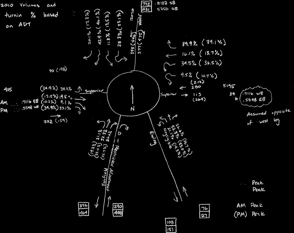
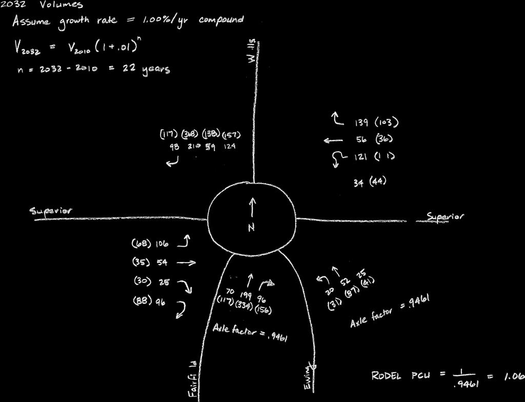
8 Surrounding Land Uses This intersection is on the near northwest side of the downtown area. The surrounding land uses are primarily commercial. Proposed Configuration The proposed intersection configuration is a roundabout. A roundabout intersection would facilitate converting Fairfield Avenue and Ewing Street from a one-way pair into two two-way streets. The one-way to two-way conversion would not operate well with the current signalized intersection configuration. A roundabout would also provide the opportunity to improve the aesthetics of this gateway into downtown from the northwest. The proposed improvements at this intersection have taken into account the existing bridge directly north of the intersection. The intention is to perform as little work as possible on the bridge. Operational Analysis Traffic Data The traffic data used for this analysis was obtained from the Northeastern Indiana Regional Coordinating Council (NIRCC). NIRCC not only performed the background traffic counts, but also provided traffic projections from their transportation demand model for the AADTs of the study area roadways after a one-way to two-way conversion on Fairfield Avenue and Ewing Street. American Structurepoint coordinated with NIRCC and used these projections to determine the AM and PM peak hour turning movements at the study intersection. The NIRCC projections and collected turning movements are provided in Appendix B and Appendix C, respectively. Capacity Analysis The following table summarizes the capacity analysis results for the year 2010 and the year RODEL software was used to analyze the traffic operations at the intersection. RODEL is based on extensive empirical data collected in the UK and analyzes the operations of a given roundabout based upon the geometric features of the roundabout. See Appendix D for a more detailed account of the results. Capacity Analysis Summary for 2010 and 2032 AM and PM Peak Hour Approach # of entry lanes 2010 AM Peak 2010 PM Peak 2032 AM Peak 2032 PM Peak LOS Avg. Delay (sec/veh) LOS Avg. Delay (sec/veh) LOS Avg. Delay (sec/veh) LOS Avg. Delay (sec/veh) North Wells Street 1 / 2* A 6.0 B 11.4 A 7.8 E / A 36.0 / 6.0 West Superior Street 1 A 5.4 A 6.6 A 7.2 A 8.4 Southwest Fairfield Avenue 1 A 5.4 A 9.0 A 7.2 C 16.8 Southeast Ewing Street 1 A 4.8 A 6.0 A 5.4 A 7.8 East Superior Street 1 A 5.4 A 6.0 A 7.2 A 7.8 * This approach was checked for a two lane entry when it was determined that a single lane entry did not perform acceptably. RODEL was used to determine the minimum number of lanes required on each of the roundabout approaches and in the circulatory roadway. Based upon the capacity analysis, the north leg will
9 require two approach lanes. Because there is a low right-turn demand on this approach, the outside lane would be designated for right turns and through movements, and the inside lane would be designated for left turns. Design Constraints The intersection of Fairfield Avenue, Ewing Street, and Wells Street has some noticeable site constraints, namely: 1) The skew between the two south legs of Fairfield Avenue and Ewing Street is significant. Anything less than 75 degrees becomes a challenge in roundabout design. The skew can be handled in one of two ways. a) Restrict right turns from Fairfield Avenue to Ewing Street. This is the least costly of the options, and it is anticipated that this movement would happen very rarely. This is the option that was chosen for the roundabout schematic. b) Use a right-turn bypass lane. This would take considerably more right-of-way, and would rarely be used. 2) The north leg (Wells Street) has a bridge in close proximity to the intersection. It is desired that the intersection improvement not impact the bridge or require any reconstruction. This was a challenge in the layout of the roundabout, as there are six lanes on the bridge. 3) The diameter of a typical single-lane roundabout with four legs is 110 to 130 feet. Because the intersection is not far from a heavy commercial district of the city, the design vehicle would be a WB-65, or a semi with a 53-foot trailer. As could be expected, the smaller the diameter, the more difficult it is for a large truck to negotiate. Due to the need to accommodate a WB-65 design vehicle and because this roundabout is a five-leg roundabout with a heavy skew between Fairfield Avenue and Ewing Street, a diameter of 150 feet will be used. 4) The existing roadway underpasses on Fairfield Avenue and Ewing Street limit the width and any re-alignment of these legs of the intersection. 5) The existing building and businesses on the northwest, southwest, and southeast corners of the intersection also restrict the size of the roundabout. With a limited budget for this project, the desire is to minimize impacts to these properties any more than necessary, while keeping in mind the Downtown Fort Wayne design standards. Roundabout Recommendations Based upon the capacity analysis results, it is desirable to build a roundabout that has a minimum of one entry lane on each approach except for the north approach, which will have two lanes. Looking at the existing curblines, pavement extents, and traffic volumes, it also is desirable to provide a two-lane entry on the east leg of the roundabout. The right lane would be a right-turn only, and the left lane would be a shared through and left-turn lane. This scenario was not analyzed in RODEL, as this approach would operate acceptably with only a single entry lane. The proposed roundabout geometry is as follows: North Leg: Wells Street is a six-lane cross-section just north of the existing intersection. It is recommended to use pavement markings to drop the inside southbound lanes on the bridge. In order
10 to protect pedestrians crossing the dropped lane, a curb bumpout shall be used near the pedestrian crossing. The northbound exit onto the bridge shall be two lanes exiting the roundabout that transitions to the three existing lanes. The existing median barrier on the bridge should be replaced near the roundabout with a raised splitter island. The splitter island should be designed such that it transitions smoothly into the remaining median barrier at the north end of the splitter island. West Leg: The west leg of Superior Street shall consist of a single entry lane and a single exit lane. Southwest Leg: Fairfield Avenue shall consist of a single entry lane and a single exit lane. Because of the skew in the proximity of Fairfield Avenue and Ewing Street, the acute right turn to Ewing Street shall be prohibited. Southeast Leg: Ewing Street shall consist of a single entry lane and a single exit lane. East Leg: The east leg of Superior Street shall consist of a two-lane entry (one right-turn only and one shared through / left-turn lane) and a single exit lane. See rendering in Appendix E for an illustration of the roundabout. ROADWAY ALTERNATIVES AND FEASIBILITY This feasibility study analyzes two alternatives for converting Fairfield Ave. and Ewing St. from one-way traffic to two-way traffic. Option 1 - Typical Cross Section Fairfield Avenue: A 3-lane typical section, from the beginning of the project to the proposed roundabout at Superior St., is being proposed for Fairfield Ave. and Ewing St. The 3-lane typical section varies in width throughout the project limits, but shall consist of a minimum 10-0 wide thru lane, one in each direction, with a 1-0 wide curb offset and a minimum 10-0 wide two-way-left-turn-lane. An 8-0 wide parking lane will be maintained in the northbound direction for Ewing St. between Brackenridge St. and Washington Blvd. and between Wayne St. and Berry St. From the beginning of the project to just north of Brackenridge Street, Fairfield Avenue will require approximately 870-feet of new curb construction to reduce the excessive pavement width. Where new curb is to be constructed, a 5-0 wide sidewalk with a 6-0 wide park strip will be reconstructed. The remaining existing curbs will be maintained along Fairfield Avenue. At the Fairfield Ave. and Jefferson Blvd. intersection, a 10-0 wide right turn lane will be added to the northbound approach
11 Ewing Street: From Baker St. to just north of Brackenridge Street, Ewing Street will be widened approximately 4-0 to the west to accommodate the proposed 3-lane section. A 5-0 wide sidewalk with a 6-0 wide park strip will be reconstructed on the west side. Baker Street: Baker Street will be converted from one-way to two-way traffic between Fairfield Ave. and Ewing St. The 2-lane section shall consist of a 10-0 wide thru lane, one in each direction, with a 1-0 wide curb offset. An 8-0 wide parking lane will be maintained in the eastbound direction. The south curb line will be reconstructed for approximately 200-feet to reduce the excessive pavement width. Where new curb is to be constructed, a 5-0 wide sidewalk with a 7-0 wide park strip will also be constructed. The remaining existing curbs will be maintained. Main Street: Main Street will be converted from a 4-lane section to a 3-lane section. The 3-lane section shall consist of one 10-8 wide thru lane in each direction, a 10-8 wide left-turn lane, and one 5-0 wide bike lane in each direction. All proposed street approaches, alleys, and drives shall be designed in accordance with City of Fort Wayne Design Standards. All proposed sidewalk shall be designed to meet current ADA requirements. Refer to Appendices F, G, and H for the proposed Option 1 roadway typical sections and conceptual plan layout. Option 2 - Typical Cross Section Fairfield Avenue and Ewing Street: A 3-lane typical section, from the beginning of the project to the proposed roundabout at Superior St., is being proposed for Fairfield Ave. and Ewing St. The 3-lane typical section varies in width throughout the project limits, but shall consist of a minimum 10-0 thru lane, one in each direction, with a 1-0 wide curb offset, a minimum 11-0 wide two-way-left-turn-lane, 0-6 curb, 6-0 wide park strip, and a 5-0 wide sidewalk. An 8-0 wide parking lane will be maintained in the northbound direction for Ewing St. between Brackenridge St. and Washington Blvd. and also between Wayne St. and Berry St. In addition to the proposed 3-lane section, exclusive right-turn lanes are proposed at the following locations: 1. Northbound approach at the Fairfield Ave. and Jefferson Blvd. intersection. 2. Southbound approach at the Fairfield Ave. and Washington Blvd. intersection. 3. Northbound approach at the Fairfield Ave. and Wayne St. intersection. 4. Southbound approach at the Fairfield Ave. and Berry St. intersection. 5. Southbound approach at the Ewing St. and Washington Blvd. intersection. 6. Southbound approach at the Ewing St. and Berry St. intersection
12 Due to existing right-of-way constraints, existing site conditions, and building locations, the new 6-0 sidewalk is proposed adjacent to the back of curb for the following segments: 1. Southbound Fairfield Ave. from the beginning of the project to just south of Lavina St. 2. Northbound Fairfield Ave. from Jefferson Blvd. to Washington Blvd. 3. Southbound Fairfield Ave. from Washington Blvd. to Berry St. 4. Southbound Fairfield Ave. from Pearl St. to just north of the Norfolk Southern Railroad Bridge. 5. Northbound Ewing St. from Wayne St. to Berry St. 6. Southbound Ewing St. from Main St. to Pearl St. 7. Northbound Ewing St. from Pearl St. to just north of the Norfolk Southern Railroad Bridge. Ewing Street from Baker St. to just north of Brackenridge St. will be widened approximately 5-0 to the west to accommodate the proposed 3-lane section. Baker Street: Baker Street will be converted from one-way to two-way traffic between Fairfield Ave. and Ewing St. The 2-lane section shall consist of one 10-0 wide thru lane in each direction with a 1-0 wide curb offset. An 8-0 wide parking lane will be maintained in the eastbound direction. This section includes reconstruction of the curb and construction of a 5-0 sidewalk with a 7-0 wide park strip on the south side and a 10-0 wide park strip on the north side of the roadway. Brackenridge Street: The existing Brackenridge Street typical section between Fairfield Ave. and Ewing St. will be maintained. The one-way roadway shall consist of a 12-0 wide westbound thru lane with an 8-0 wide parking lane on each side of the roadway. This section includes reconstruction of the curb and construction of a 5-0 sidewalk with a 5-0 wide park strip on the south side and a 13-0 wide park strip on the north side of the roadway. Jefferson Boulevard: Jefferson Blvd., between Fairfield Ave. and Ewing St., includes reconstruction of the curb and construction of a 5-0 sidewalk with a 6-0 wide park strip on the south side of the roadway. Main Street: Main Street will be converted from a 4-lane section to a 3-lane section. The 3-lane section shall consist of one 10-8 wide thru lane in each direction, a 10-8 wide left-turn lane, and one 5-0 wide bike lane in each direction. Between Fairfield Ave. and Ewing St., the roadway includes reconstruction of the curb and a 5-0 sidewalk with a 6-0 wide park strip on both sides of the roadway. In order to convert the existing 4-lane section to a 3-lane section with bike lanes, Main Street will be required to drop one eastbound lane west of Fulton Street. On the east side of Ewing St., one of the westbound lanes will become the left turn lane to southbound Ewing Street. All proposed street approaches, alleys, and drives shall be designed in accordance with City of Fort Wayne Design Standards. All proposed sidewalk and curb ramps shall be designed to meet current ADA requirements
13 Refer to Appendices F, G, and H for the proposed Option 2 roadway typical section and the conceptual plan layout. Option 1 & 2 - Pavement Recommendations Full depth pavement construction is being proposed within the limits of the roundabout. The existing asphalt pavement within the project limits shall be milled 1.5 inches and resurfaced with 1.5 inches of asphalt. The vertical alignment shall follow the existing vertical alignment of the roadway. Replacement of the existing concrete pavement outside the limits of the roundabout is not anticipated. Option 1 & 2 - Horizontal Alignment Improvement: The horizontal alignment shall be improved at the following locations: 1. Fairfield Ave. from Lavina St. to just north of Brackenridge St. 2. Intersection of Fairfield Ave. & Jefferson Blvd. 3. Ewing St. from Baker St. to just north of Brackenridge St. 4. Intersection of Ewing St. & Jefferson Blvd. The horizontal alignment will be modified from existing in these locations to avoid right of way impacts to Parkview Field and increase safety by aligning opposing traffic through the intersections. Elsewhere, the horizontal alignment along Fairfield Ave. and Ewing St. shall remain the same as the existing horizontal alignment. Option 1 & 2 Drainage Recommendations This project shall include the installation of new storm sewer inlets, manholes, and/or pipe at the locations of added auxiliary lanes, pavement width reduction, improved curb radii, and at the proposed roundabout. Where existing curb locations are being maintained, the existing storm sewer castings shall be adjusted to grade. Option 1 & 2 - Lighting, Signals, Signage, and Landscaping The City of Fort Wayne is responsible for the street lighting within the project limits. Under Option 1, the existing lighting will remain in place. Under Option 2, the existing lighting shall be replaced with new LED street lighting (post mounted acorn style) spaced at 100ft according to the City of Fort Wayne Downtown Design Manual. Signal modernization and/or modification of the existing traffic signals will be required for all intersections within the project limits along both Fairfield Avenue and Ewing Street. The existing traffic signal at the intersection of Fairfield Ave., Ewing St., Superior St., and Wells St. will be removed due to converting the signalized intersection to a roundabout. New signal heads, poles, and mast arms will be required at each intersection. In order to accommodate left turn movements, additional signal heads and modifications will also be required on cross streets with two-directional traffic. The designer shall coordinate further with the City of Fort Wayne to determine the extent of the signal work and possibility of salvaging existing poles at each intersection
14 Existing signage, including overhead signs, shall be replaced as part of this project. Proposed Landscaping is not included in the scope of Option 1. Landscaping is included into the scope of Option 2 according to the City of Fort Wayne Downtown Design Manual. Street trees will be placed along the roadway at a spacing of 50ft. The vicinity of the roundabout will include landscape elements and shall be coordinated with the City of Fort Wayne Urban Designer. For the purposes of this feasibility study, various trees, shrubs, ornamental grasses, and groundcover were included for cost estimation. Option 1 & 2 - Utilities It is not anticipated that underground utilities will need to be relocated as part of this project. For Options 1 and 2, the existing overhead transmission lines along the west side of Ewing St. shall be relocated to accommodate the proposed 3-lane section. The existing overhead transmission lines along the south side of Superior St. shall be relocated to accommodate the proposed roundabout. Existing utility poles may need to be relocated at isolated locations but will not be necessary for the majority of the corridor. The designer is to coordinate with the City of Fort Wayne and all utility companies to minimize utility conflicts. Option 1 & 2 - Intersection Improvements Intersection improvements are required at the following intersections: 1. Fairfield Avenue / Baker Street The existing triangular traffic island will be removed. Fairfield Ave. and Baker St. will both be converted from one-way to two-way traffic. This intersection will be un-signalized with Baker St. being stop-controlled. 2. Fairfield Avenue / Brackenridge Street The excessive pavement width on Fairfield Ave. at Brackenridge St. will be reduced to accommodate the proposed 3-lane section. This intersection will be un-signalized with Brackenridge St. being stop-controlled. 3. Fairfield Avenue / Ewing Street / Superior Street / Wells Street The existing 5-leg signalized intersection will be converted to a 5-leg roundabout. Refer to Appendix F, G and H for the conceptual plan layout
15 OPINION OF PROBABLE COSTS Option 1 Roadway and Roundabout Construction Items Roadway Construction $ 2,443,300 Utilities $ 200,000 Construction Total $ 2,643,300 Non-Construction Items Engineering $ 442,400 Right-of-Way/Land Acquisition $ 235,000 Construction Inspection $ 244,300 Non-Construction Total $ 921,700 PROJECT TOTAL $ 3,565,000 Option 2 Roadway and Roundabout Construction Items Roadway Construction $ 4,255,100 Utilities $ 200,000 Construction Total $ 4,455,100 Non-Construction Items Engineering $ 592,100 Right-of-Way/Land Acquisition $ 569,000 Construction Inspection $ 425,500 Non-Construction Total $ 1,586,600 PROJECT TOTAL $ 6,041,700 Refer to the opinions of probable cost in Appendices I, J, and K
16 SURVEY REQUIREMENTS Fairfield Avenue: The survey limits for Fairfield Ave. should begin approximately 125 south of Hendricks St. and extend north to the intersection of Fairmount Place for a total length of 3,525 feet. The survey coverage should extend approximately 25 beyond the existing right-of-way or to building faces. Ewing Street: The survey limits for Ewing St. should begin at the intersection of Baker St. and extend north to the Wells St. Bridge over the St. Mary s River for a total distance of 3,450 feet. The survey coverage should extend approximately 25 beyond the existing right-of-way or to building faces. Baker Street: The survey limits for Baker St. should begin at Fairfield Ave. and extend approximately 200 east of Ewing Street for a total distance of 700 feet. The survey coverage should extend approximately 25 beyond the existing right-of-way or to building faces. Brackenridge Street: The survey limits of Brackenridge should begin approximately 100 west of Fairfield Ave. and extend approximately 100 east of Ewing Street for a total distance of 700 feet. The survey coverage should extend approximately 25 beyond the existing right-of-way or to building faces. Jefferson Boulevard: The survey limits for Jefferson Blvd. should begin at Fairfield Ave. and extend to Ewing St. on the south side of the roadway for a distance of 500 feet. The survey coverage should extend approximately 25 beyond the existing right-of-way or to building faces. Main Street: The survey limits for Main St. should begin at Fulton St. and extend to Maiden Lane for a total distance of 1,400 feet. The survey coverage should extend approximately 25 beyond the existing right-of-way or to building faces. An additional 400 feet of survey from Broadway Street to Fulton Street will be required as well. The additional survey coverage should extend from the back of existing sidewalk on the south side of the roadway to the back of existing sidewalk on the north side of the roadway for a width of 63 feet. Superior Street: The survey limits for Superior St. should begin approximately 300 west of Fairfield Ave. and extend approximately 400 east of Ewing Street for a distance of 1,000 feet. The survey coverage should extend approximately 25 beyond the existing right-of-way or to building faces
17 Wells Street: The survey limits for Wells St. should extend from the back of existing sidewalk on the west side to the back of existing sidewalk on the east side of the roadway from Superior St. north to Commerce Drive for a distance of 1,100 feet. The survey coverage should extend approximately 25 beyond the existing right-of-way or to building faces. RIGHT-OF-WAY IMPACTS The existing right-of-way will accommodate the proposed typical sections along Fairfield Avenue and Ewing Street except for isolated locations. The proposed roundabout will require permanent rightof-way. Curb radii improvements and the addition of right-turn lanes at various locations will require permanent right-of-way. In Option 1, it is estimated that permanent right-of-way will be acquired from 5 commercial parcels (0.24 acres). The effected parcels include commercial parking lots, a gas station parking lot, and used car lots. In Option 2, it is estimated that permanent right-of-way will be acquired from 13 commercial parcels (0.42 acres). The effected parcels include commercial parking lots, a gas station parking lot, a church property, an apartment parking lot, and used car lots. It is anticipated that no relocations will be necessary as part of this project. Refer to the conceptual plan in Appendix F, G, and H, for approximate permanent right-of-way locations. TRAFFIC MAINTENANCE DURING CONSTRUCTION In order to construct the proposed roundabout in a timely manner, it is recommended to have full closure of Fairfield Avenue and Ewing Street from Pearl Street to Wells Street Bridge. A detour could be set up to divert southbound Wells St. traffic to the Van Buren St. Bridge, Harrison St. Bridge, and/or the Clinton St. Bridge to get to Main Street. The preferred detour for Superior St. would be via Van Buren St. and Harrison St. to access Main Street. Fairfield Ave. and Ewing St. would be closed from Pearl St. to Superior Street. Local access would be maintained during construction. It is desirable to maintain a minimum of one lane and a maximum of two lanes of traffic on Fairfield Ave. and Ewing St., from the beginning of the project to Pearl St., at all times during construction. Maintaining a reduced number of travel lanes would provide minimal disruption to thru traffic and local traffic, maintain access to adjacent properties, and provide a safe environment for construction workers. The final maintenance of traffic scheme will be evaluated and further determined during the design phase in conference with the City of Fort Wayne. RECOMMENDATIONS/CONCLUSIONS/CONCURRENCE The purpose of this study is to assess the feasibility of converting Fairfield Avenue and Ewing Street from one-way traffic to two-way traffic. The study also assesses the feasibility of a roundabout at the intersection of Fairfield Avenue, Ewing Street, Superior Street, and Wells Street. The proposed project scope includes a modernization and/or modification of the existing traffic signals, updated signage, improved intersection layouts, and the addition of a 5-leg roundabout at the intersection of Fairfield Ave., Ewing St., Superior St., and Wells St. Option 1 is a more cost effective alternative due to utilizing the existing pavement widths and using pavement markings to convert the roadways to two-way traffic. Spot improvements will be required to reduce excessive pavement widths. Option 2 costs are considerably higher, but this option incorporates the Downtown Fort Wayne Template for
18 adding LED lighting, curb reconstruction, and sidewalk reconstruction with a parkstrip throughout the corridor. Landscaping and trees will be added within the parkstrip as part of Option 2. Based upon gathered data, field visits, and the information compiled in this report, Option 1 and Option 2 as well as the proposed 5-leg roundabout are both feasible alternatives to be constructed as outlined in the Project Recommendations section of this report. In conclusion, this project will be designed under the City of Fort Wayne Design Standards
19 APPENDICES Appendix A Graphics Appendix B Traffic Counts and Projections Appendix C Intersection Turning Movements Appendix D RODEL Analysis Appendix E Conceptual Roundabout Rendering Appendix F Option 1 and 2 Typical Sections Appendix G Option 1 Conceptual Plan Layout Appendix H Option 2 Conceptual Plan Layout Appendix I Option 1 Roadway Opinion of Probable Cost Appendix J Option 2 Roadway Opinion of Probable Cost Appendix K Roundabout Opinion of Probable Cost
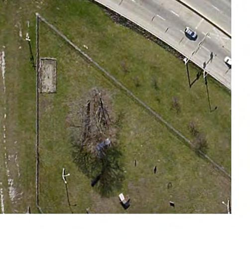
20 Appendix A Graphics
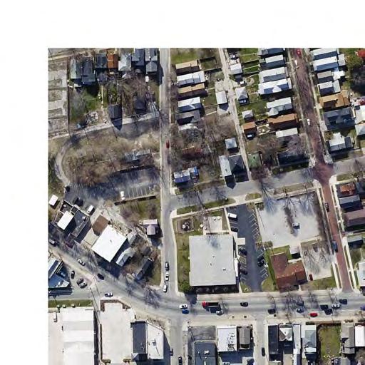
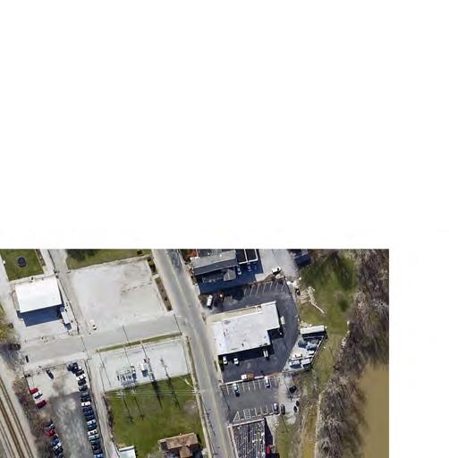

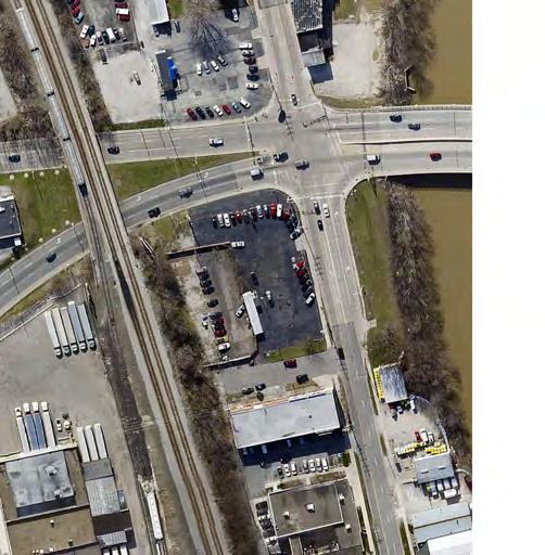

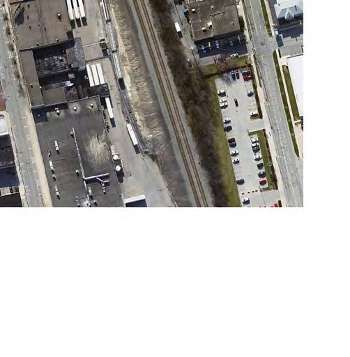
21 BRACKENRIDGE STREET LAVINA STREET BAKER STREET PROJECT LOCATION MAP 1 = 225 MAIN STREET BERRY STREET WASHINGTON BLVD. WAYNE STREET WELLS STREET JEFFERSON BLVD. FAIRFIELD AVENUE SUPERIOR STREET PEARL STREET EWING STREET
22 Facing north at Fairfield Ave. and Hendricks St. Intersection Facing north at Fairfield Ave. and Baker St. Intersection Facing north at Fairfield Ave. and Lavina St. Intersection Facing south at Fairfield Ave. and Brackenridge St. Intersection Fairfield Ave. & Ewing St. Conversion One-Way to Two-Way A-2
23 Facing north at Ewing St. and Brackenridge St. Intersection Facing south at Ewing St. and Brackenridge St. Intersection Facing north at Ewing St. and Brackenridge St. Intersection Facing south at Ewing St. and Main St. Intersection Fairfield Ave. & Ewing St. Conversion One-Way to Two-Way A-3
24 Facing north at Ewing St. and Main St. Intersection Facing north at Ewing St. and Wayne St. Intersection Facing south at Fairfield Ave. and Pearl St. Intersection Facing north at Fairfield Ave. and Pearl St. Intersection Fairfield Ave. & Ewing St. Conversion One-Way to Two-Way A-4
25 Facing north on Fairfield Ave. at Railroad Underpass Facing south on Ewing St. at Railroad Underpass Facing north on Ewing St. at Railroad Underpass Facing east at Superior St. and Wells St. Intersection Fairfield Ave. & Ewing St. Conversion One-Way to Two-Way A-5
26 Facing west at Superior St. and Wells St. Intersection Facing south at Ewing St. and Pearl St. Intersection Facing south at Fairfield Ave. and Main St. Intersection Facing north at Fairfield Ave. and Berry St. Intersection Fairfield Ave. & Ewing St. Conversion One-Way to Two-Way A-6
27 Facing south at Fairfield Ave. and Berry St. Intersection Facing north at Fairfield Ave. and Berry St. Intersection Facing south at Fairfield Ave. and Washington Blvd. Intersection Facing north at Fairfield Ave. and Washington Blvd. Intersection Fairfield Ave. & Ewing St. Conversion One-Way to Two-Way A-7
28 Appendix B Traffic Counts and Projections
29 Traffic Data Provided by NIRCC Ewing St From To AADT Year AM K FTR PM K FTR Superior St Main St Main St Berry St Berry St Wayne St Wayne St Washington Blvd Washington Blvd Jefferson Blvd Jefferson Blvd Brackenridge St Brackenridge St Fairfield St Fairfield Ave From To AADT Year AM K FTR PM K FTR Superior St Main St Main St Berry St Berry St Wayne St Wayne St Washington Blvd Washington Blvd Jefferson Blvd Jefferson Blvd Brackenridge St Brackenridge St Baker St Jefferson Blvd From To AADT Year AM K FTR PM K FTR Broadway Fairfield St Fairfield St Ewing St Ewing St Webster St Washington Blvd From To AADT Year AM K FTR PM K FTR Broadway Fairfield St Fairfield St Ewing St Ewing St Webster St Berry St From To AADT Year AM K FTR PM K FTR Broadway Fairfield St Fairfield St Ewing St Ewing St Webster St Wayne St From To AADT Year AM K FTR PM K FTR Broadway Fairfield St Fairfield St Ewing St Ewing St Webster St Main St From To AADT Year AM K FTR PM K FTR AM D FTR PM D FTR 24 D FTR Broadway Fairfield St /EB /WB /EB Fairfield St Ewing St /EB /WB /WB Ewing St Harrison St /EB /WB /WB Wells St From To AADT Year AM K FTR PM K FTR AM D FTR PM D FTR 24 D FTR Railroad Superior St /SB /SB /SB Superior St From To AADT Year AM K FTR PM K FTR AM D FTR PM D FTR 24 D FTR Ross St Fairfield Ave /EB /WB /WB Fairfield Ave Wells St NA NA NA
30
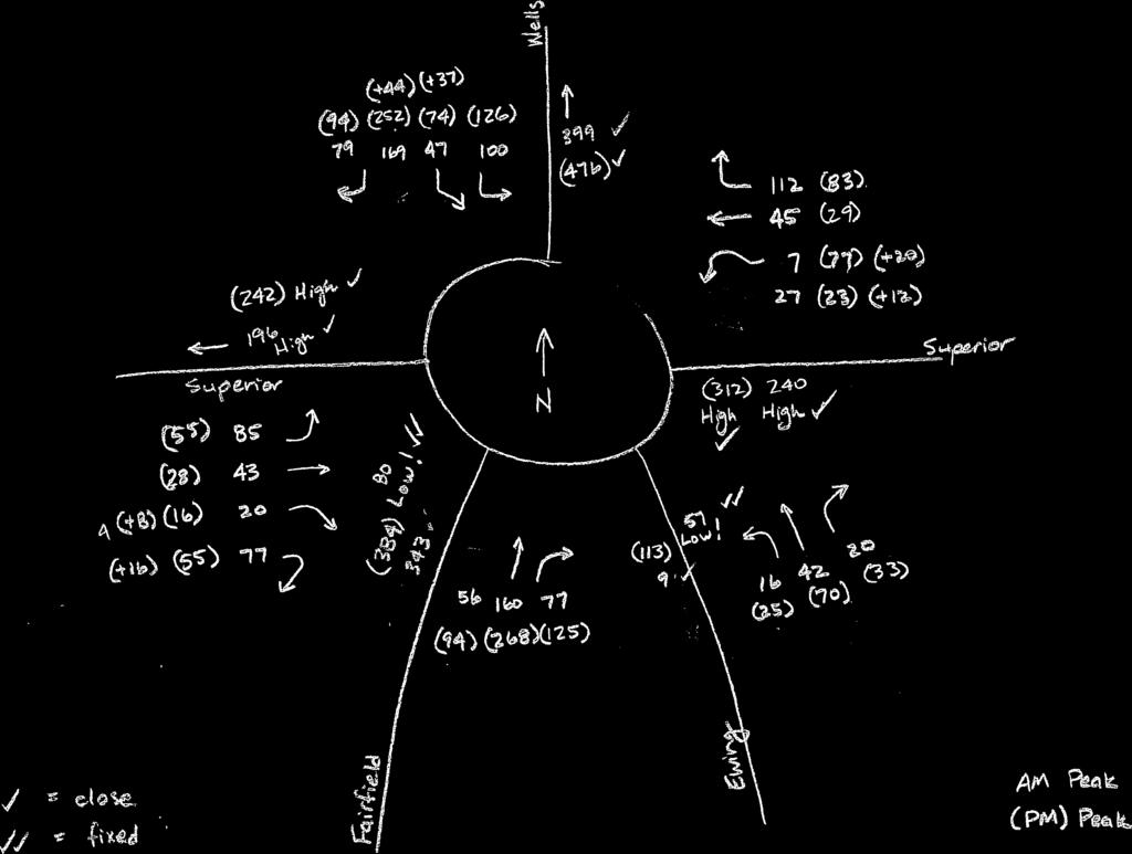
31 Appendix C Intersection Turning Movements


32
33
34
35 Appendix D RODEL Analysis
36 2010 AM Peak This RODEL output shows that a single-lane roundabout could be expected to operate at a LOS A, with an average delay per vehicle of 5.7 seconds. The maximum queue in the peak hour would be only one vehicle on the Wells, Fairfield, an east Superior approaches. The confidence level (CL) is set at 85 percent, which is considered to be a pessimistic (conservative) estimate of capacity. The flow factor (FLOF) is set at 0.80 because the 2010 traffic volumes are 80% of the 2032 traffic volumes, which have been entered in the FLOWS field
37 2010 PM Peak This RODEL output shows that a single-lane roundabout could be expected to operate at a LOS A, with an average delay per vehicle of 9.0 seconds. The maximum queue in the peak hour would be approximately three vehicles on the Wells Street approach. The flow factor (FLOF) is set at 0.80 because the 2010 traffic volumes are 80% of the 2032 traffic volumes, which have been entered in the FLOWS field
38 2032 AM Peak This RODEL output shows that a single-lane roundabout could be expected to operate at a LOS A, with an average delay per vehicle of 7.2 seconds. The maximum queue in the peak hour would only be one vehicle on four of the five approaches

39 2032 PM Peak (Single Lane) This RODEL output shows that a single-lane roundabout could be expected to operate at a LOS C, with an average delay per vehicle of 21.1 seconds. The maximum queue in the peak hour would be approximately 15 vehicles on the Wells Street approach
40 2032 PM Peak (Two Lane Entry for Wells Street) This RODEL output shows that adding a second entry lane on the Wells Street approach would improve the 2032 PM peak LOS to A, with an average delay per vehicle of 8.7 seconds. The maximum queue in the peak hour would be approximately 4 vehicles on the Fairfield Avenue approach
41 Appendix E Conceptual Roundabout Rendering
42
43 Appendix F Option 1 and 2 Typical Sections
44 1-0" 10-0" Min. 10-0" Min. 10-0" Min. 1-0" S.B. Travel Lane T.W.L.T.L. N.B. Travel Lane Existing Ground Exist. Slope R Exist. Slope Exist. Slope R Exist. Slope Existing Ground Existing Asphalt Pavement Existing Asphalt Pavement Option 1 Typical Section - Fairfield Ave. & Ewing St. Sta to Fairfield Ave. Sta to Ewing St. Sta to Ewing St. 1-0" 10-0" Min. 10-0" Min. 10-0" Min. 1-0" S.B. Travel Lane T.W.L.T.L. N.B. Travel Lane Existing Ground Exist. Slope Exist. Slope Exist. Slope Exist. Slope Existing Ground Existing Concrete Pavement Existing Concrete Pavement Option 1 Typical Section - Fairfield Ave. & Ewing St. Sta to Fairfield Avenue Sta to Ewing Street Sta to Ewing Street 5-0" 6-0" 1-0" 10-0" Min. 11-0" Min. 10-0" Min. 1-0" 6-0" 5-0" Sidewalk Parkstrip 6" S.B. Travel Lane T.W.L.T.L. N.B. Travel Lane 6" Parkstrip Sidewalk Existing Ground F 2% 2% A 2% 2% A A 2% 2% A F 2% 2% Existing Ground Subgrade Treatment Subgrade Treatment Option 1 & 2 Typical Section - Fairfield Ave. & Ewing St. Sta to Fairfield Ave. Sta to Ewing St. A F Mainline Full Depth PCCP Concrete Sidewalk, 4" LEGEND R Milling, Asphalt, 1.5" 165 #/Syd. HMA Surface RECOMMENDED FOR APPROVAL DESIGN ENGINEER DATE CITY OF FORT WAYNE HORIZONTAL SCALE 1 4" = 1-0" VERTICAL SCALE BRIDGE FILE DESIGNATION NO. K Mainline Full Depth HMA Pavement Concrete Curb Type II-A Concrete Curb Type III DESIGNED: ASU DRAWN: ASU TYPICAL CROSS SECTIONS SURVEY BOOK SHEETS of 26 Sodding, Nursery CHECKED: SMC CHECKED: SMC FAIRFIED AVE. & EWING ST. CONTRACT PROJECT NO. scrites 3/28/2012 5:16:29 PM P:\2011\00049\D. Drawings\ RD.TY.01.dgn
45 5-0" 6-0" 1-0" 10-0" Min. 11-0" Min. 10-0" Min. 1-0" 6-0" 5-0" Sidewalk Parkstrip S.B. Travel Lane T.W.L.T.L. N.B. Travel Lane Parkstrip Sidewalk 6" 2-0" 2-0" 6" Existing Ground F 2% 2% K Exist. Slope R Exist. Slope Exist. Slope R Exist. Slope K F 2% 2% Existing Ground Existing Asphalt Pavement Existing Asphalt Pavement Option 2 Typical Section - Fairfield Ave. & Ewing St. Sta to Fairfield Ave. Sta to Ewing St. Sta to Ewing St. 5-0" 6-0" 1-0" 10-0" Min. 11-0" Min. 10-0" Min. 1-0" 6-0" 5-0" Sidewalk Parkstrip 6" S.B. Travel Lane T.W.L.T.L. N.B. Travel Lane 6" Parkstrip Sidewalk Existing Ground F 2% 2% Exist. Slope Exist. Slope Exist. Slope Exist. Slope F 2% 2% Existing Ground Existing Concrete Pavement Existing Concrete Pavement Option 2 Typical Section - Fairfield Ave. & Ewing St. Sta to Fairfield Avenue Sta to Ewing Street Sta to Ewing Street A F Mainline Full Depth PCCP Concrete Sidewalk, 4" LEGEND R Milling, Asphalt, 1.5" 165 #/Syd. HMA Surface RECOMMENDED FOR APPROVAL DESIGN ENGINEER DATE CITY OF FORT WAYNE HORIZONTAL SCALE 1 4" = 1-0" VERTICAL SCALE BRIDGE FILE DESIGNATION NO. K Mainline Full Depth HMA Pavement Concrete Curb Type II-A Concrete Curb Type III DESIGNED: ASU DRAWN: ASU TYPICAL CROSS SECTIONS SURVEY BOOK SHEETS of 26 Sodding, Nursery CHECKED: SMC CHECKED: SMC FAIRFIED AVE. & EWING ST. CONTRACT PROJECT NO. scrites 3/28/2012 5:16:30 PM P:\2011\00049\D. Drawings\ RD.TY.02.dgn
46 5-0" 10-0" 1-0" 10-0" 10-0" 8-0" 7-0" 5-0" Sidewalk Parkstrip W.B. Travel Lane E.B. Travel Lane Parking Lane Parkstrip Sidewalk 6" 6" Existing Ground Exist. Slope R Exist. Slope R Exist. Slope Existing Ground Existing Asphalt Pavement Existing Asphalt Pavement Option 1 Typical Section - Baker St. 5-0" 10-0" 1-0" 10-0" 10-0" 8-0" 7-0" 5-0" Sidewalk Parkstrip W.B. Travel Lane E.B. Travel Lane Parking Lane Parkstrip Sidewalk 6" 2-0" 2-0" 6" Existing Ground F 2% 2% K Exist. Slope R Exist. Slope R Exist. Slope K F 2% 2% Existing Ground Existing Asphalt Pavement Existing Asphalt Pavement Option 2 Typical Section - Baker St. A F Mainline Full Depth PCCP Concrete Sidewalk, 4" LEGEND R Milling, Asphalt, 1.5" 165 #/Syd. HMA Surface RECOMMENDED FOR APPROVAL DESIGN ENGINEER DATE CITY OF FORT WAYNE HORIZONTAL SCALE 1 4" = 1-0" VERTICAL SCALE BRIDGE FILE DESIGNATION NO. K Mainline Full Depth HMA Pavement Concrete Curb Type II-A Concrete Curb Type III DESIGNED: ASU DRAWN: ASU TYPICAL CROSS SECTIONS SURVEY BOOK SHEETS of 26 Sodding, Nursery CHECKED: SMC CHECKED: SMC BAKER STREET CONTRACT PROJECT NO. scrites 3/28/2012 5:16:30 PM P:\2011\00049\D. Drawings\ RD.TY.03.dgn
47 5-0" 6-0" 5-0" 10-8" 10-8" 10-8" 5-0" 11-0" Sidewalk Parkstrip Bike Lane W.B. Travel Lane Left Turn Lane E.B. Travel Lane Bike Lane Sidewalk 6" 6" Existing Ground Exist. Slope R Exist. Slope R Exist. Slope Existing Ground Existing Asphalt Pavement Existing Asphalt Pavement Option 1 Typical Section - Main St. 5-0" 6-0" 5-0" 10-8" 10-8" 10-8" 5-0" 6-0" 5-0" Sidewalk Parkstrip Bike Lane W.B. Travel Lane Left Turn Lane E.B. Travel Lane Bike Lane Parkstrip Sidewalk 6" 2-0" 2-0" 6" Existing Ground F 2% 2% K Exist. Slope R Exist. Slope R Exist. Slope K F 2% 2% Existing Ground Existing Asphalt Pavement Existing Asphalt Pavement Option 2 Typical Section - Main St. A F Mainline Full Depth PCCP Concrete Sidewalk, 4" LEGEND R Milling, Asphalt, 1.5" 165 #/Syd. HMA Surface RECOMMENDED FOR APPROVAL DESIGN ENGINEER DATE CITY OF FORT WAYNE HORIZONTAL SCALE 1 4" = 1-0" VERTICAL SCALE BRIDGE FILE DESIGNATION NO. K Mainline Full Depth HMA Pavement Concrete Curb Type II-A Concrete Curb Type III DESIGNED: ASU DRAWN: ASU TYPICAL CROSS SECTIONS SURVEY BOOK SHEETS of 26 Sodding, Nursery CHECKED: SMC CHECKED: SMC MAIN STREET CONTRACT PROJECT NO. scrites 3/28/2012 5:16:31 PM P:\2011\00049\D. Drawings\ RD.TY.04.dgn
48 Appendix G Option 1 Conceptual Plan Layout
49 Hendricks St. Baker St. Lavina St. Brackenridge St Fairfield Ave. Proposed R/W Fairfield Ave Ewing St. Ewing St. HORIZONTAL SCALE BRIDGE FILE RECOMMENDED FOR APPROVAL CITY OF FORT WAYNE 1" = 80 VERTICAL SCALE DESIGNATION NO. DESIGN ENGINEER DATE DESIGNED: ASU DRAWN: ASU FAIRFIELD AVE. & EWING ST. SURVEY BOOK SHEETS of CHECKED: SMC CHECKED: SMC CONCEPTUAL PLAN - OPTION 1 CONTRACT PROJECT NO. scrites 3/28/2012 5:16:32 PM P:\2011\00049\D. Drawings\ RD.CD.OPTION1.01.dgn
50 Fairfield Ave Proposed R/W Fairfield Ave. Jefferson Blvd. Washington Blvd. Wayne St Ewing St Ewing St. HORIZONTAL SCALE BRIDGE FILE RECOMMENDED FOR APPROVAL CITY OF FORT WAYNE 1" = 80 VERTICAL SCALE DESIGNATION NO. DESIGN ENGINEER DATE DESIGNED: ASU DRAWN: ASU FAIRFIELD AVE. & EWING ST. SURVEY BOOK SHEETS of CHECKED: SMC CHECKED: SMC CONCEPTUAL PLAN - OPTION 1 CONTRACT PROJECT NO. scrites 3/28/2012 5:16:33 PM P:\2011\00049\D. Drawings\ RD.CD.OPTION1.02.dgn
51 Fairfield Ave. Fairfield Ave. Ewing St. Pearl St Berry St. Main St. Proposed R/W Ewing St. HORIZONTAL SCALE BRIDGE FILE RECOMMENDED FOR APPROVAL CITY OF FORT WAYNE 1" = 80 VERTICAL SCALE DESIGNATION NO. DESIGN ENGINEER DATE DESIGNED: ASU DRAWN: ASU FAIRFIELD AVE. & EWING ST. SURVEY BOOK SHEETS of CHECKED: SMC CHECKED: SMC CONCEPTUAL PLAN - OPTION 1 CONTRACT PROJECT NO. scrites 3/28/2012 5:16:34 PM P:\2011\00049\D. Drawings\ RD.CD.OPTION1.03.dgn
52 Superior St Proposed R/W Proposed R/W Fairfield Ave. Pearl St Ewing St. Wels St Proposed R/W Superior St. HORIZONTAL SCALE BRIDGE FILE RECOMMENDED FOR APPROVAL CITY OF FORT WAYNE 1" = 80 VERTICAL SCALE DESIGNATION NO. DESIGN ENGINEER DATE DESIGNED: ASU DRAWN: ASU FAIRFIELD AVE. & EWING ST. SURVEY BOOK SHEETS of CHECKED: SMC CHECKED: SMC CONCEPTUAL PLAN - OPTION 1 CONTRACT PROJECT NO. scrites 3/28/2012 5:16:35 PM P:\2011\00049\D. Drawings\ RD.CD.OPTION1.04.dgn
53 Fairfield Ave Ewing St Pearl St. Ewing St. Fulton St. Webster St. Main St. HORIZONTAL SCALE BRIDGE FILE RECOMMENDED FOR APPROVAL CITY OF FORT WAYNE 1" = 80 VERTICAL SCALE DESIGNATION NO. DESIGN ENGINEER DATE DESIGNED: ASU DRAWN: ASU MAIN STREET SURVEY BOOK SHEETS of CHECKED: SMC CHECKED: SMC CONCEPTUAL PLAN - OPTION 1 CONTRACT PROJECT NO. scrites 3/28/2012 5:16:36 PM P:\2011\00049\D. Drawings\ RD.CD.OPTION1.05.dgn
54 Hendricks St. Baker St. Lavina St. Brackenridge St Fairfield Ave. Proposed R/W Fairfield Ave Ewing St. Ewing St. HORIZONTAL SCALE BRIDGE FILE RECOMMENDED FOR APPROVAL CITY OF FORT WAYNE 1" = 80 VERTICAL SCALE DESIGNATION NO. DESIGN ENGINEER DATE DESIGNED: ASU DRAWN: ASU FAIRFIELD AVE. & EWING ST. SURVEY BOOK SHEETS of CHECKED: SMC CHECKED: SMC CONCEPTUAL PLAN - OPTION 1 CONTRACT PROJECT NO. scrites 3/28/2012 5:16:38 PM P:\2011\00049\D. Drawings\ RD.CD.OPTION1.06.dgn
55 Fairfield Ave Proposed R/W Fairfield Ave. Jefferson Blvd. Washington Blvd. Wayne St Ewing St Ewing St. HORIZONTAL SCALE BRIDGE FILE RECOMMENDED FOR APPROVAL CITY OF FORT WAYNE 1" = 80 VERTICAL SCALE DESIGNATION NO. DESIGN ENGINEER DATE DESIGNED: ASU DRAWN: ASU FAIRFIELD AVE. & EWING ST. SURVEY BOOK SHEETS of CHECKED: SMC CHECKED: SMC CONCEPTUAL PLAN - OPTION 1 CONTRACT PROJECT NO. scrites 3/28/2012 5:17:00 PM P:\2011\00049\D. Drawings\ RD.CD.OPTION1.07.dgn
56 Fairfield Ave. Fairfield Ave. Ewing St. Pearl St Berry St. Main St. Proposed R/W Ewing St. HORIZONTAL SCALE BRIDGE FILE RECOMMENDED FOR APPROVAL CITY OF FORT WAYNE 1" = 80 VERTICAL SCALE DESIGNATION NO. DESIGN ENGINEER DATE DESIGNED: ASU DRAWN: ASU FAIRFIELD AVE. & EWING ST. SURVEY BOOK SHEETS of CHECKED: SMC CHECKED: SMC CONCEPTUAL PLAN - OPTION 1 CONTRACT PROJECT NO. scrites 3/28/2012 5:17:17 PM P:\2011\00049\D. Drawings\ RD.CD.OPTION1.08.dgn
57 Superior St Proposed R/W Proposed R/W Fairfield Ave. Pearl St Wels St Ewing St. Proposed R/W Superior St. HORIZONTAL SCALE BRIDGE FILE RECOMMENDED FOR APPROVAL CITY OF FORT WAYNE 1" = 80 VERTICAL SCALE DESIGNATION NO. DESIGN ENGINEER DATE DESIGNED: ASU DRAWN: ASU FAIRFIELD AVE. & EWING ST. SURVEY BOOK SHEETS of CHECKED: SMC CHECKED: SMC CONCEPTUAL PLAN - OPTION 1 CONTRACT PROJECT NO. scrites 3/28/2012 5:17:37 PM P:\2011\00049\D. Drawings\ RD.CD.OPTION1.09.dgn
58 Fairfield Ave Ewing St Pearl St. Ewing St. Fulton St. Webster St. Main St. HORIZONTAL SCALE BRIDGE FILE RECOMMENDED FOR APPROVAL CITY OF FORT WAYNE 1" = 80 VERTICAL SCALE DESIGNATION NO. DESIGN ENGINEER DATE DESIGNED: ASU DRAWN: ASU MAIN STREET SURVEY BOOK SHEETS of CHECKED: SMC CHECKED: SMC CONCEPTUAL PLAN - OPTION 1 CONTRACT PROJECT NO. scrites 3/28/2012 5:17:53 PM P:\2011\00049\D. Drawings\ RD.CD.OPTION1.10.dgn
59 Appendix H Option 2 Conceptual Plan Layout
60 Hendricks St. Baker St. Lavina St. Brackenridge St Fairfield Ave. Proposed R/W Fairfield Ave Ewing St. Ewing St. HORIZONTAL SCALE BRIDGE FILE RECOMMENDED FOR APPROVAL CITY OF FORT WAYNE 1" = 80 VERTICAL SCALE DESIGNATION NO. DESIGN ENGINEER DATE DESIGNED: ASU DRAWN: ASU FAIRFIELD AVE. & EWING ST. SURVEY BOOK SHEETS of CHECKED: SMC CHECKED: SMC CONCEPTUAL PLAN - OPTION 2 CONTRACT PROJECT NO. scrites 3/28/2012 5:18:09 PM P:\2011\00049\D. Drawings\ RD.CD.OPTION2.01.dgn
61 Fairfield Ave Proposed R/W Proposed R/W Fairfield Ave. Proposed R/W Proposed R/W Jefferson Blvd. Washington Blvd. Wayne St. Ewing St. Proposed R/W Ewing St. HORIZONTAL SCALE BRIDGE FILE RECOMMENDED FOR APPROVAL CITY OF FORT WAYNE 1" = 80 VERTICAL SCALE DESIGNATION NO. DESIGN ENGINEER DATE DESIGNED: ASU DRAWN: ASU FAIRFIELD AVE. & EWING ST. SURVEY BOOK SHEETS of CHECKED: SMC CHECKED: SMC CONCEPTUAL PLAN - OPTION 2 CONTRACT PROJECT NO. scrites 3/28/2012 5:18:10 PM P:\2011\00049\D. Drawings\ RD.CD.OPTION2.02.dgn
62 35+00 Proposed R/W Fairfield Ave. Fairfield Ave. Ewing St. Pearl St Berry St. Main St. Proposed R/W Proposed R/W Proposed R/W Proposed R/W Ewing St. HORIZONTAL SCALE BRIDGE FILE RECOMMENDED FOR APPROVAL CITY OF FORT WAYNE 1" = 80 VERTICAL SCALE DESIGNATION NO. DESIGN ENGINEER DATE DESIGNED: ASU DRAWN: ASU FAIRFIELD AVE. & EWING ST. SURVEY BOOK SHEETS of CHECKED: SMC CHECKED: SMC CONCEPTUAL PLAN - OPTION 2 CONTRACT PROJECT NO. scrites 3/28/2012 5:18:11 PM P:\2011\00049\D. Drawings\ RD.CD.OPTION2.03.dgn
63 Proposed R/W Superior St Proposed R/W Proposed R/W Fairfield Ave. Pearl St Ewing St. Wels St Proposed R/W Superior St. HORIZONTAL SCALE BRIDGE FILE RECOMMENDED FOR APPROVAL CITY OF FORT WAYNE 1" = 80 VERTICAL SCALE DESIGNATION NO. DESIGN ENGINEER DATE DESIGNED: ASU DRAWN: ASU FAIRFIELD AVE. & EWING ST. SURVEY BOOK SHEETS of CHECKED: SMC CHECKED: SMC CONCEPTUAL PLAN - OPTION 2 CONTRACT PROJECT NO. scrites 3/28/2012 5:18:12 PM P:\2011\00049\D. Drawings\ RD.CD.OPTION2.04.dgn
64 Fairfield Ave Proposed R/W Ewing St Pearl St. Ewing St. Fulton St. Webster St. Main St. Proposed R/W Proposed R/W HORIZONTAL SCALE BRIDGE FILE RECOMMENDED FOR APPROVAL CITY OF FORT WAYNE 1" = 80 VERTICAL SCALE DESIGNATION NO. DESIGN ENGINEER DATE DESIGNED: ASU DRAWN: ASU MAIN STREET SURVEY BOOK SHEETS of CHECKED: SMC CHECKED: SMC CONCEPTUAL PLAN - OPTION 2 CONTRACT PROJECT NO. scrites 3/28/2012 5:18:13 PM P:\2011\00049\D. Drawings\ RD.CD.OPTION2.05.dgn


65 Hendricks St. Baker St. Lavina St. Brackenridge St Fairfield Ave. Proposed R/W Fairfield Ave Ewing St. Ewing St. HORIZONTAL SCALE BRIDGE FILE RECOMMENDED FOR APPROVAL CITY OF FORT WAYNE 1" = 80 VERTICAL SCALE DESIGNATION NO. DESIGN ENGINEER DATE DESIGNED: ASU DRAWN: ASU FAIRFIELD AVE. & EWING ST. SURVEY BOOK SHEETS of CHECKED: SMC CHECKED: SMC CONCEPTUAL PLAN - OPTION 2 CONTRACT PROJECT NO. scrites 3/28/2012 5:18:14 PM P:\2011\00049\D. Drawings\ RD.CD.OPTION2.06.dgn


66 Fairfield Ave Proposed R/W Proposed R/W Fairfield Ave. Proposed R/W Proposed R/W Jefferson Blvd. Washington Blvd. Wayne St. Ewing St. Proposed R/W Ewing St. HORIZONTAL SCALE BRIDGE FILE RECOMMENDED FOR APPROVAL CITY OF FORT WAYNE 1" = 80 VERTICAL SCALE DESIGNATION NO. DESIGN ENGINEER DATE DESIGNED: ASU DRAWN: ASU FAIRFIELD AVE. & EWING ST. SURVEY BOOK SHEETS of CHECKED: SMC CHECKED: SMC CONCEPTUAL PLAN - OPTION 2 CONTRACT PROJECT NO. scrites 3/28/2012 5:18:33 PM P:\2011\00049\D. Drawings\ RD.CD.OPTION2.07.dgn


67 35+00 Proposed R/W Fairfield Ave. Fairfield Ave. Ewing St. Pearl St Berry St. Main St. Proposed R/W Proposed R/W Proposed R/W Proposed R/W Ewing St. HORIZONTAL SCALE BRIDGE FILE RECOMMENDED FOR APPROVAL CITY OF FORT WAYNE 1" = 80 VERTICAL SCALE DESIGNATION NO. DESIGN ENGINEER DATE DESIGNED: ASU DRAWN: ASU FAIRFIELD AVE. & EWING ST. SURVEY BOOK SHEETS of CHECKED: SMC CHECKED: SMC CONCEPTUAL PLAN - OPTION 2 CONTRACT PROJECT NO. scrites 3/28/2012 5:18:48 PM P:\2011\00049\D. Drawings\ RD.CD.OPTION2.08.dgn


68 Proposed R/W Superior St Proposed R/W Proposed R/W Fairfield Ave. Pearl St Ewing St. Wels St Proposed R/W Superior St. HORIZONTAL SCALE BRIDGE FILE RECOMMENDED FOR APPROVAL CITY OF FORT WAYNE 1" = 80 VERTICAL SCALE DESIGNATION NO. DESIGN ENGINEER DATE DESIGNED: ASU DRAWN: ASU FAIRFIELD AVE. & EWING ST. SURVEY BOOK SHEETS of CHECKED: SMC CHECKED: SMC CONCEPTUAL PLAN - OPTION 2 CONTRACT PROJECT NO. scrites 3/28/2012 5:19:04 PM P:\2011\00049\D. Drawings\ RD.CD.OPTION2.09.dgn


69 Fairfield Ave Proposed R/W Ewing St Pearl St. Ewing St. Fulton St. Webster St. Main St. Proposed R/W Proposed R/W HORIZONTAL SCALE BRIDGE FILE RECOMMENDED FOR APPROVAL CITY OF FORT WAYNE 1" = 80 VERTICAL SCALE DESIGNATION NO. DESIGN ENGINEER DATE DESIGNED: ASU DRAWN: ASU MAIN STREET SURVEY BOOK SHEETS of CHECKED: SMC CHECKED: SMC CONCEPTUAL PLAN - OPTION 2 CONTRACT PROJECT NO. scrites 3/28/2012 5:19:18 PM P:\2011\00049\D. Drawings\ RD.CD.OPTION2.10.dgn
70 Appendix I Option 1 Roadway Opinion of Probable Cost
71 QUANTITY COST ESTIMATE One-Way to Two-Way - Option 1 Project No.: Des. No.: N/A N/A ESTIMATED PROJECT COST Total: $1,238, % Contingency: $247, ESTIMATED TOTAL: $1,485, ID Item No Description Quantity Unit Unit Price Item Total CONSTRUCTION ENGINEERING 1.00 LS $43, $43, MOBILIZATION AND DEMOBILIZATION 1.00 LS $32, $32, CLEARING RIGHT OF WAY 1.00 LS $32, $32, PAVEMENT REMOVAL SYS $6.25 $2, CURB, CONCRETE, INTEGRAL, REMOVE LFT $5.30 $1, CURB, CONCRETE, REMOVE 1, LFT $5.25 $9, SIDEWALK, CONCRETE, REMOVE 1, SYS $8.00 $9, EXCAVATION, COMMON CYS $12.00 $6, BORROW CYS $6.00 $1, SUBGRADE TREATMENT, TYPE IA 1, SYS $5.25 $6, SUBGRADE TREATMENT, TYPE IIIA SYS $9.50 $3, SUBBASE FOR PCCP 2.00 CYS $32.50 $65.00 MILLING, ASPHALT, 1 1/2 IN 18, SYS $0.75 $14, HMA SURFACE, TYPE C 1, TON $70.00 $111, HMA INTERMEDIATE, TYPE C TON $60.00 $5, HMA BASE, TYPE C TON $55.00 $27, ASPHALT FOR TACK COAT 5.10 TON $ $1, PCCP, 12 IN 5.00 SYS $50.00 $ SIDEWALK, CONCRETE, 4 IN SYS $32.00 $30, CURB, INTEGRAL, CONCRETE LFT $12.50 $1, CURB, CONCRETE 1, LFT $18.00 $31, PCCP FOR APPROACHES, 9 IN SYS $46.00 $17, TOPSOIL CYS $20.00 $3, SODDING, NURSERY 1, SYS $3.10 $4, PIPE, TYPE 2 CIRCULAR 12 IN LFT $33.00 $3, CATCH BASIN, K EACH $2, $25, MAINTAINING TRAFFIC 1.00 LS $32, $32, TRAFFIC SIGNAL INSTALLATION 1.00 LS $774, $774, Prepared By: Date: Checked By: Date: Cost Estimate Page 1 of 29
72 One-Way to Two-Way - Option 1 SHEET NO.: 2 OF CONSTRUCTION ENGINEERING TOTAL = 1.00 LS
73 One-Way to Two-Way - Option 1 SHEET NO.: 3 OF MOBILIZATION AND DEMOBILIZATION TOTAL = 1.00 LS
74 One-Way to Two-Way - Option 1 SHEET NO.: 4 OF CLEARING RIGHT OF WAY TOTAL = 1.00 LS
75 One-Way to Two-Way - Option 1 SHEET NO.: 5 OF PAVEMENT REMOVAL TOTAL = SYS Location Area (SYS) Fairfield / Baker Center Island 15 Fairfield Drive #1 34 Fairfield Drive #2 17 Fairfield Drive #3 25 Fairfield Drive #4 189 Ewing Drive #1 32 Ewing Drive #2 24 Ewing Drive #3 31 Ewing Drive #4 21 Ewing - North of Jefferson - West Curb Line
76 One-Way to Two-Way - Option 1 SHEET NO.: 6 OF CURB, CONCRETE, INTEGRAL, REMOVE TOTAL = LFT Location Length (LFT) Fairfield - Between Jefferson & Washington SB 164 Ewing - Between Jefferson & Washington SB
77 One-Way to Two-Way - Option 1 SHEET NO.: 7 OF CURB, CONCRETE, REMOVE TOTAL = 1, LFT Location Fairfield - Between Hendricks & Lavina SB Fairfield - Between Lavina & Brackenridge SB Length (LFT) Fairfield - Between Brackenridge & Jefferson SB Fairfield - Between Hendricks & Baker NB Fairfield - Between Lavina & Brackenridge NB 201 Fairfield - Between Brackenridge & Jefferson NB 229 Baker - Between Fairfield & Ewing EB 198 Ewing - Between Baker & Brackenridge SB 350 Ewing - Between Brackenridge & Jefferson SB
78 One-Way to Two-Way - Option 1 SHEET NO.: 8 OF SIDEWALK, CONCRETE, REMOVE TOTAL = 1, SYS Location Area (SYS) Fairfield - Between Hendricks & Lavina SB 141 Fairfield - Between Lavina & Brackenridge SB 97 Fairfield - Between Brackenridge & Jefferson SB 79 Fairfield - SE Corner at Baker NB 335 Fairfield - Between Lavina & Brackenridge NB 103 Fairfield - Between Brackenridge & Jefferson NB 260 Ewing - Between Baker & Brackenridge SB 172 Ewing - NW Corner at Brackenridge SB 24 Ewing - NW Corner at Brackenridge SB
79 One-Way to Two-Way - Option 1 SHEET NO.: 9 OF EXCAVATION, COMMON TOTAL = CYS * Assumed Depth of Cut = 1' Location Area (SYS) Fairfield - Between Hendricks & Lavina SB 88 Fairfield - Between Lavina & Brackenridge SB 325 Fairfield - Between Brackenridge & Jefferson SB 88 Fairfield - SE Corner at Baker NB 243 Fairfield - Between Lavina & Brackenridge NB 166 Fairfield - Between Brackenridge & Jefferson NB 316 Ewing - Between Baker & Brackenridge SB 239 Ewing - Between Brackenridge & Jefferson SB 202 Volume (CYS)
80 One-Way to Two-Way - Option 1 SHEET NO.: 10 OF BORROW TOTAL = CYS * Assumed Depth of Fill = 1' Location Area (SYS) Volume (CYS) Fairfield - Between Hendricks & Lavina SB Fairfield - Between Lavina & Brackenridge SB Fairfield - Between Brackenridge & Jefferson SB Fairfield - SE Corner at Baker NB Fairfield - Between Lavina & Brackenridge NB Fairfield - Between Brackenridge & Jefferson NB Ewing - Between Baker & Brackenridge SB Ewing - Between Brackenridge & Jefferson SB
81 One-Way to Two-Way - Option 1 SHEET NO.: 11 OF SUBGRADE TREATMENT, TYPE IA TOTAL = 1, SYS Location Area (SYS) Fairfield - Between Hendricks & Lavina SB 83 Fairfield - Between Lavina & Brackenridge SB 108 Fairfield - Between Brackenridge & Jefferson SB 74 Fairfield - Between Hendricks & Baker NB 75 Fairfield - Between Lavina & Brackenridge NB 103 Fairfield - Between Brackenridge & Jefferson NB 82 Fairfield / Baker Center Island - Asph. Pavement 15 Fairfield / Jefferson SE Corner Asph. Pavement Widening 162 Fairfield / Jefferson NW Corner Conc. Pavement Widening 17 Baker - Between Fairfield & Ewing EB 98 Ewing - Between Baker & Brackenridge SB 240 Ewing - Between Brackenridge & Jefferson SB
82 One-Way to Two-Way - Option 1 SHEET NO.: 12 OF SUBGRADE TREATMENT, TYPE IIIA TOTAL = SYS Location Area (SYS) Fairfield Drive #1 47 Fairfield Drive #2 27 Fairfield Drive #3 35 Fairfield Drive #4 149 Ewing Drive #1 30 Ewing Drive #2 24 Ewing Drive #3 45 Ewing Drive #
83 One-Way to Two-Way - Option 1 SHEET NO.: 13 OF SUBBASE FOR PCCP TOTAL = 2.00 CYS * 0.75' Depth Location Area (SYS) Fairfield - Between Jefferson & Washington SB 5 Volume (CYS)
84 One-Way to Two-Way - Option 1 SHEET NO.: 14 OF MILLING, ASPHALT, 1 1/2 IN TOTAL = 18, SYS Location Area (SYS) Fairfield - Between BOP & Jefferson 5093 Ewing - Between Baker & Jefferson 4347 Baker - Between Fairfield & Ewing 1902 Ewing - Between Berry & Pearl 2673 Main - Between Fulton & Fairfield 1506 Main - Between Fairfield & Ewing 1383 Main - Between Ewing & Webster
85 One-Way to Two-Way - Option 1 SHEET NO.: 15 OF HMA SURFACE, TYPE C TOTAL = 1, TON Location Area (SYS) Fairfield - Between BOP & Jefferson 5390 Ewing - Between Baker & Jefferson 4616 Baker - Between Fairfield & Ewing 1946 Ewing - Between Berry & Pearl 2673 Main - Between Fulton & Fairfield 1506 Main - Between Fairfield & Ewing 1383 Main - Between Ewing & Webster 1791 Rate (#/SYS) Volume (TON)
86 One-Way to Two-Way - Option 1 SHEET NO.: 16 OF HMA INTERMEDIATE, TYPE C TOTAL = TON Location Area (SYS) Rate (#/SYS) Volume (TON) Fairfield - Between Hendricks & Lavina SB Fairfield - Between Lavina & Brackenridge SB Fairfield - Between Brackenridge & Jefferson SB Fairfield - SE Corner at Baker NB Fairfield - Between Lavina & Brackenridge NB Fairfield - Between Brackenridge & Jefferson NB Ewing - Between Baker & Brackenridge SB Ewing - Between Brackenridge & Jefferson SB
87 One-Way to Two-Way - Option 1 SHEET NO.: 17 OF HMA BASE, TYPE C TOTAL = TON Location Area (SYS) Rate (#/SYS) Volume (TON) Fairfield - Between Hendricks & Lavina SB Fairfield - Between Lavina & Brackenridge SB Fairfield - Between Brackenridge & Jefferson SB Fairfield - SE Corner at Baker NB Fairfield - Between Lavina & Brackenridge NB Fairfield - Between Brackenridge & Jefferson NB Ewing - Between Baker & Brackenridge SB Ewing - Between Brackenridge & Jefferson SB Location Area (SYS) Rate (#/SYS) Volume (TON) Fairfield - Between Hendricks & Lavina SB Fairfield - Between Lavina & Brackenridge SB Fairfield - Between Brackenridge & Jefferson SB Fairfield - SE Corner at Baker NB Fairfield - Between Lavina & Brackenridge NB Fairfield - Between Brackenridge & Jefferson NB Ewing - Between Baker & Brackenridge SB Ewing - Between Brackenridge & Jefferson SB
88 One-Way to Two-Way - Option 1 SHEET NO.: 18 OF ASPHALT FOR TACK COAT TOTAL = 5.10 TON Location Area (SYS) Rate (TON/SYS) Volume (TON) Fairfield - Between BOP & Jefferson Ewing - Between Baker & Jefferson Baker - Between Fairfield & Ewing Ewing - Between Berry & Pearl Main - Between Fulton & Fairfield Main - Between Fairfield & Ewing Main - Between Ewing & Webster
89 One-Way to Two-Way - Option 1 SHEET NO.: 19 OF PCCP, 12 IN TOTAL = 5.00 SYS Location Area (SYS) Fairfield - Between Jefferson & Washington SB
90 One-Way to Two-Way - Option 1 SHEET NO.: 20 OF SIDEWALK, CONCRETE, 4 IN TOTAL = SYS Location Area (SYS) Fairfield - Between Hendricks & Lavina SB 143 Fairfield - Between Lavina & Brackenridge SB 108 Fairfield - Between Brackenridge & Jefferson SB 84 Fairfield - SE Corner at Baker NB 188 Fairfield - Between Lavina & Brackenridge NB 101 Fairfield - Between Brackenridge & Jefferson NB 134 Ewing - Between Baker & Brackenridge SB 164 Ewing - NW Corner at Brackenridge SB 14 Ewing - Between Jefferson & Wayne SB
91 One-Way to Two-Way - Option 1 SHEET NO.: 21 OF CURB, INTEGRAL, CONCRETE TOTAL = LFT Location Length (LFT) Fairfield - Between Jefferson and Washington SB 46 Ewing - Between Jefferson and Washington SB
92 One-Way to Two-Way - Option 1 SHEET NO.: 22 OF CURB, CONCRETE TOTAL = 1, LFT Location Length (LFT) Fairfield - Between Hendricks & Lavina SB 85 Fairfield - Between Lavina & Brackenridge SB 208 Fairfield - Between Brackenridge & Jefferson SB 145 Fairfield - SE Corner at Baker NB 342 Fairfield - Between Lavina & Brackenridge NB 170 Fairfield - Between Brackenridge & Jefferson NB 232 Ewing - Between Baker & Brackenridge SB 274 Ewing - NW Corner at Brackenridge SB
93 One-Way to Two-Way - Option 1 SHEET NO.: 23 OF PCCP FOR APPROACHES, 9 IN TOTAL = SYS Location Area (SYS) Fairfield Drive #1 47 Fairfield Drive #2 27 Fairfield Drive #3 35 Fairfield Drive #4 149 Ewing Drive #1 30 Ewing Drive #2 24 Ewing Drive #3 45 Ewing Drive #
94 One-Way to Two-Way - Option 1 SHEET NO.: 24 OF TOPSOIL TOTAL = CYS * Assumed Depth of Fill = 0.33' Location Area (SYS) Volume (CYS) Fairfield - Between Hendricks & Lavina SB 15 2 Fairfield - Between Lavina & Brackenridge SB Fairfield - Between Brackenridge & Jefferson SB 64 8 Fairfield - SE Corner at Baker NB Fairfield - Between Lavina & Brackenridge NB Fairfield - Between Brackenridge & Jefferson NB Ewing - Between Baker & Brackenridge SB Ewing - Between Brackenridge & Jefferson SB Fairfield - Between Jefferson & Washington SB 30 4 Ewing - Between Jefferson & Washington SB
95 One-Way to Two-Way - Option 1 SHEET NO.: 25 OF SODDING, NURSERY TOTAL = 1, SYS Location Area (SYS) Fairfield - Between Hendricks & Lavina SB 15 Fairfield - Between Lavina & Brackenridge SB 279 Fairfield - Between Brackenridge & Jefferson SB 64 Fairfield - SE Corner at Baker NB 261 Fairfield - Between Lavina & Brackenridge NB 104 Fairfield - Between Brackenridge & Jefferson NB 263 Ewing - Between Baker & Brackenridge SB 177 Ewing - Between Brackenridge & Jefferson SB 164 Fairfield - Between Jefferson & Washington SB 30 Ewing - Between Jefferson & Washington SB
96 One-Way to Two-Way - Option 1 SHEET NO.: 26 OF PIPE, TYPE 2 CIRCULAR 12 IN TOTAL = LFT Location Length (LFT) Fairfield Ave. 80 Ewing St. 30 Baker St
97 One-Way to Two-Way - Option 1 SHEET NO.: 27 OF CATCH BASIN, K10 TOTAL = EACH Location EACH Fairfield Ave. 8 Ewing St. 3 Baker St
98 One-Way to Two-Way - Option 1 SHEET NO.: 28 OF MAINTAINING TRAFFIC TOTAL = 1.00 LS
99 One-Way to Two-Way - Option 1 SHEET NO.: 29 OF TRAFFIC SIGNAL INSTALLATION TOTAL = 1.00 LS Converting Existing Signals from One-Way to Two-Way Traffic
100 Appendix J Option 2 Roadway Opinion of Probable Cost
101 QUANTITY COST ESTIMATE One-Way to Two-Way - Option 2 Project No.: Des. No.: N/A N/A ESTIMATED PROJECT COST Total: $2,747, % Contingency: $549, ESTIMATED TOTAL: $3,297, ID Item No Description Quantity Unit Unit Price Item Total CONSTRUCTION ENGINEERING 1.00 LS $97, $97, MOBILIZATION AND DEMOBILIZATION 1.00 LS $72, $72, CLEARING RIGHT OF WAY 1.00 LS $72, $72, PAVEMENT REMOVAL 2, SYS $6.25 $14, CURB, CONCRETE, INTEGRAL, REMOVE 5, LFT $5.30 $29, CURB, CONCRETE, REMOVE 7, LFT $5.25 $39, SIDEWALK, CONCRETE, REMOVE 8, SYS $8.00 $67, EXCAVATION, COMMON 1, CYS $12.00 $20, BORROW CYS $6.00 $4, SUBGRADE TREATMENT, TYPE IA 4, SYS $5.25 $25, SUBGRADE TREATMENT, TYPE IIIA 2, SYS $9.50 $20, SUBBASE FOR PCCP CYS $32.50 $2, MILLING, ASPHALT, 1 1/2 IN 18, SYS $0.75 $14, HMA SURFACE, TYPE C 1, TON $70.00 $121, HMA INTERMEDIATE, TYPE C TON $60.00 $18, HMA BASE, TYPE C 1, TON $55.00 $88, ASPHALT FOR TACK COAT 7.90 TON $ $2, PCCP, 12 IN SYS $50.00 $14, SIDEWALK, CONCRETE, 4 IN 7, SYS $32.00 $227, CURB, INTEGRAL, CONCRETE 4, LFT $12.50 $60, CURB, CONCRETE 6, LFT $18.00 $114, PCCP FOR APPROACHES, 9 IN 2, SYS $46.00 $100, TOPSOIL CYS $20.00 $13, SODDING, NURSERY 6, SYS $3.10 $18, TREE GRATE 6.00 EACH $1, $6, PLANT, DECIDUOUS TREE, SINGLE STEM, OVER 2 TO 2.5 IN EACH $ $42, PIPE, TYPE 2 CIRCULAR 12 IN LFT $33.00 $6, CATCH BASIN, K EACH $2, $39, MAINTAINING TRAFFIC 1.00 LS $72, $72, TRAFFIC SIGNAL INSTALLATION 1.00 LS $774, $774, LIGHT POLE, ORNAMENTAL EACH $3, $543, Prepared By: Date: Checked By: Date: Cost Estimate Page 1 of 41
102 One-Way to Two-Way - Option 2 SHEET NO.: 2 OF CONSTRUCTION ENGINEERING TOTAL = 1.00 LS
103 One-Way to Two-Way - Option 2 SHEET NO.: 3 OF MOBILIZATION AND DEMOBILIZATION TOTAL = 1.00 LS
104 One-Way to Two-Way - Option 2 SHEET NO.: 4 OF CLEARING RIGHT OF WAY TOTAL = 1.00 LS
105 One-Way to Two-Way - Option 2 SHEET NO.: 5 OF PAVEMENT REMOVAL TOTAL = 2, SYS Location Area (SYS) Fairfield / Baker Center Island 15 Fairfield Drive #1 35 Fairfield Drive #2 17 Fairfield Drive #3 30 Fairfield Drive #4 23 Fairfield Drive #5 25 Fairfield Drive #6 66 Fairfield Drive #7 194 NW Corner Fairfield / Jefferson 14 NE Corner Fairfield / Jefferson 30 Fairfield Drive #8 36 Fairfield Drive #9 34 Fairfield Drive #10 23 Fairfield Drive #11 23 Fairfield Drive #12 27 Fairfield Drive #13 36 Fairfield Drive #14 30 Fairfield Drive #15 32 Fairfield Drive #16 23 Fairfield Drive #17 23 Fairfield Drive #18 32 Fairfield Drive #19 17 Fairfield Drive #20 33 Fairfield Drive #21 32 Fairfield Drive #22 23 Fairfield Drive #23 23 Fairfield Drive #24 40 Fairfield Drive #25 84 Fairfield Drive #26 39 Fairfield Drive #27 42 Fairfield Drive #28 23 Fairfield Drive #
106 One-Way to Two-Way - Option 2 SHEET NO.: 6 OF PAVEMENT REMOVAL TOTAL = 2, SYS Fairfield Drive #30 30 Fairfield Drive #31 26 Ewing Drive #1 37 Ewing Drive #2 20 Ewing Drive #3 30 Ewing Drive #4 31 West Curb Line - Ewing N of Jefferson 29 Ewing Drive #5 22 Ewing Drive #6 25 NW Corner Ewing & Washington 11 Ewing Drive #7 40 Ewing Drive #8 26 Ewing Drive #9 20 Ewing Drive #10 69 Ewing Drive #11 69 Ewing Drive #12 32 Ewing Drive #13 59 Ewing Drive #14 95 Baker Drive #1 34 Baker Drive #2 34 Jefferson Drive #1 125 Main St Drive #1 99 Main St Drive #2 88 Main St Drive #
107 One-Way to Two-Way - Option 2 SHEET NO.: 7 OF CURB, CONCRETE, INTEGRAL, REMOVE TOTAL = 5, LFT For Concrete Pavement Location Length (LFT) Fairfield - Between Jefferson & Washington SB 383 Fairfield - Between Jefferson & Washington NB 360 Fairfield - Between Washington & Wayne SB 370 Fairfield - Between Washington & Wayne NB 372 Fairfield - Between Wayne & Berry SB 355 Fairfield - Between Wayne & Berry NB 355 Fairfield - Between Berry & Main SB 352 Fairfield - Between Berry & Main NB 346 Fairfield - Between Main & Pearl SB 166 Fairfield - Between Main & Pearl NB 170 Ewing - Between Jefferson & Washington SB 375 Ewing - Between Washington & Wayne SB 380 Ewing - Between Washington & Wayne NB 44 Ewing - Between Wayne & Berry SB 358 Ewing - Between Wayne & Berry NB 358 Fairfield - From Pearl to Roundabout SB 280 Fairfield - From Pearl to Roundabout NB 131 Ewing - From Pearl to Roundabout SB 300 Ewing - From Pearl to Roundabout NB
108 One-Way to Two-Way - Option 2 SHEET NO.: 8 OF CURB, CONCRETE, REMOVE TOTAL = 7, LFT For Asphalt Pavement Location Length (LFT) Fairfield - South of Hendricks SB 87 Fairfield - Between Hendricks & Lavina SB 312 Fairfield - Between Lavina & Brackenridge SB 180 Fairfield - Between Brackenridge & Jefferson SB Fairfield - Between Hendricks & Baker NB Fairfield - Between Lavina & Brackenridge NB 351 Fairfield - Between Brackenridge & Jefferson NB 712 Baker - Between Fairfield & Ewing EB 384 Baker - Between Fairfield & Ewing WB 467 Brackenridge - Between Fairfield & Ewing Northside 306 Brackenridge - Between Fairfield & Ewing Southside 358 Jefferson - Between Fairfield & Ewing Southside 285 Ewing - Between Baker & Brackenridge SB 357 Ewing - Between Baker & Brackenridge NB 333 Ewing - Between Brackenridge & Jefferson SB 772 Ewing - Between Berry & Main SB 376 Ewing - Between Berry & Main NB 371 Ewing - Between Main & Peal SB 188 Ewing - Between Main & Peal NB 218 Main St - Between Fairfield & Ewing Northside 337 Main St - Between Fairfield & Ewing Southside
109 One-Way to Two-Way - Option 2 SHEET NO.: 9 OF SIDEWALK, CONCRETE, REMOVE TOTAL = 8, SYS Location Area (SYS) Fairfield - South of Hendricks SB 99 Fairfield - Between Hendricks & Lavina SB 212 Fairfield - Between Lavina & Brackenridge SB 97 Fairfield - Between Brackenridge & Jefferson SB 384 Fairfield - Between Hendricks & Lavina NB 158 Fairfield - Between Lavina & Brackenridge NB 211 Fairfield - Between Brackenridge & Jefferson NB 465 Fairfield - Between Jefferson & Washington SB 221 Fairfield - Between Jefferson & Washington NB 300 Fairfield - Between Washington & Wayne SB Fairfield - Between Washington & Wayne NB Fairfield - Between Wayne & Berry SB Fairfield - Between Wayne & Berry NB 277 Fairfield - Between Berry & Main SB 218 Fairfield - Between Berry & Main NB 131 Fairfield - Between Main & Pearl SB 131 Fairfield - Between Main & Pearl NB 149 Ewing - Between Baker & Brackenridge SB 170 Ewing - Between Baker & Brackenridge NB 157 Ewing - Between Brackenridge & Jefferson SB 446 Ewing - Between Jefferson & Washington SB 239 Ewing - Between Washington & Wayne SB 364 Ewing - Between Washington & Wayne NB 47 Ewing - Between Wayne & Berry SB 421 Ewing - Between Wayne & Berry NB 289 Ewing - Between Berry & Main SB 212 Ewing - Between Berry & Main NB 197 Ewing - Between Main & Pearl SB 108 Ewing - Between Main & Pearl NB 195 Baker - Between Fairfield & Ewing EB 328 Baker - Between Fairfield & Ewing WB 217 Brackenridge - Between Fairfield & Ewing Northside 178 Brackenridge - Between Fairfield & Ewing Southside
110 One-Way to Two-Way - Option 2 SHEET NO.: 10 OF SIDEWALK, CONCRETE, REMOVE TOTAL = 8, SYS Jefferson - Between Fairfield & Ewing Southside Main St - Between Fairfield & Ewing EB Main St - Between Fairfield & Ewing WB Fairfield - From Pearl to Roundabout SB 147 Fairfield - From Pearl to Roundabout NB 11 Ewing - From Pearl to Roundabout SB 22 Ewing - From Pearl to Roundabout NB
111 One-Way to Two-Way - Option 2 SHEET NO.: 11 OF EXCAVATION, COMMON TOTAL = 1, CYS * Assumed Depth of Cut = 1' Location Area (SYS) Volume (CYS) Fairfield - South of Hendricks SB Fairfield - Between Hendricks & Lavina SB Fairfield - Between Lavina & Brackenridge SB Fairfield - Between Brackenridge & Jefferson SB Fairfield - Between Hendricks & Baker NB Fairfield - Between Lavina & Brackenridge NB Fairfield - Between Brackenridge & Jefferson NB Fairfield / Baker Center Island - Asph. Pavement 15 5 Fairfield - NE Corner of Washington 16 6 Fairfield - SW Corner of Wayne 16 6 Fairfield - SE Corner of Wayne 16 6 Fairfield - NW Corner of Berry Added Aux. Lane Fairfield - SW Corner of Main St 16 6 Fairfield - SE Corner of Main St 18 6 Fairfield - NE Corner of Main St 18 6 Fairfield - SW Corner of Pearl 19 7 Fairfield - SE Corner of Pearl 11 4 Ewing - Between Baker & Brackenridge SB Ewing - Between Baker & Brackenridge NB Ewing - Between Brackenridge & Jefferson SB Ewing - NW Corner of Washington Added Aux Lane SB Ewing - NE Corner of Washington 20 7 Ewing - Between Berry & Main SB Ewing - Between Berry & Main NB Ewing - Between Main & Pearl SB Ewing - Between Main & Pearl NB Baker - Between Fairfield & Ewing EB Baker - Between Fairfield & Ewing WB Brackenridge - Between Fairfield & Ewing Northside Brackenridge - Between Fairfield & Ewing Southside Jefferson - Between Fairfield & Ewing Southside Main Street - Between Fairfield & Ewing EB Main Street - Between Fairfield & Ewing WB
112 One-Way to Two-Way - Option 2 SHEET NO.: 12 OF BORROW TOTAL = CYS * Assumed Depth of Fill = 1' Location Area (SYS) Volume (CYS) Fairfield - South of Hendricks SB 18 6 Fairfield - Between Hendricks & Lavina SB Fairfield - Between Lavina & Brackenridge SB Fairfield - Between Brackenridge & Jefferson SB Fairfield - Between Hendricks & Baker NB Fairfield - Between Lavina & Brackenridge NB Fairfield - Between Brackenridge & Jefferson NB Fairfield - NW Corner of Jefferson Fairfield - NE Corner of Jefferson Fairfield - NE Corner of Washington 9 3 Fairfield - SW Corner of Wayne 9 3 Fairfield - SE Corner of Wayne 9 3 Fairfield - NW Corner of Berry Added Aux. Lane Fairfield - SW Corner of Main St 9 3 Fairfield - SE Corner of Main St 9 3 Fairfield - NE Corner of Main St 9 3 Fairfield - SW Corner of Pearl 8 3 Fairfield - SE Corner of Pearl 6 2 Ewing - Between Baker & Brackenridge SB Ewing - Between Baker & Brackenridge NB Ewing - Between Brackenridge & Jefferson SB Ewing - Jefferson & Washington SB Ewing - SW Corner of Washington 16 6 Ewing - NW Corner of Washington Added Aux Lane SB Ewing - NE Corner of Washington 9 3 Ewing - Between Berry & Main SB Ewing - Between Berry & Main NB Ewing - Between Main & Pearl SB Ewing - Between Main & Pearl NB Baker - Between Fairfield & Ewing EB Baker - Between Fairfield & Ewing WB Brackenridge - Between Fairfield & Ewing Northside Brackenridge - Between Fairfield & Ewing Southside
113 One-Way to Two-Way - Option 2 SHEET NO.: 13 OF BORROW TOTAL = CYS Jefferson - Between Fairfield & Ewing Southside Main Street - Between Fairfield & Ewing EB Main Street - Between Fairfield & Ewing WB
114 One-Way to Two-Way - Option 2 SHEET NO.: 14 OF SUBGRADE TREATMENT, TYPE IA TOTAL = 4, SYS Location Area (SYS) Fairfield - Between Jefferson & Washington 17 Fairfield - NE Corner of Washington 17 Fairfield - SW Corner of Wayne 17 Fairfield - SE Corner of Wayne 17 Fairfield - NW Corner of Berry / Added Aux. Lane 153 Fairfield - SW Corner of Main St 8 Fairfield - SE Corner of Main St 8 Fairfield - NE Corner of Main St 8 Fairfield - SW Corner of Pearl 103 Fairfield - SE Corner of Pearl 11 Fairfield - NW Corner of Pearl 13 Fairfield - NE Corner of Pearl 7 Ewing - NW Corner of Washington / Added Aux. Lane 134 Ewing - NE Corner of Washington 21 Ewing - NW Corner of Pearl 35 Fairfield - South of Hendricks SB 44 Fairfield - Between Hendricks & Lavina SB 181 Fairfield - Between Lavina & Brackenridge SB 105 Fairfield - Between Brackenridge & Jefferson SB 459 Fairfield - Between Hendricks & Baker NB 74 Fairfield - Between Baker & Brackenridge NB 183 Fairfield - Between Brackenridge & Jefferson NB 268 Fairfield / Baker Center Island - Asph. Pavement 15 Fairfield / Jefferson SE Corner Asph. Pavement Widening 189 Ewing - Between Baker & Brackenridge SB 282 Ewing - Between Baker & Brackenridge NB 166 Ewing - Between Brackenridge & Jefferson SB 474 Ewing - NW Corner of Berry / Added Aux. Lane 150 Ewing - Between Berry & Main SB 120 Ewing - Between Berry & Main NB 185 Ewing - Between Main & Pearl SB 129 Ewing - Between Main & Pearl NB 133 Concrete Pavement Widening Asphalt Pavement Widening
115 One-Way to Two-Way - Option 2 SHEET NO.: 15 OF SUBGRADE TREATMENT, TYPE IA TOTAL = 4, SYS Baker - Between Fairfield & Ewing EB 234 Baker - Between Fairfield & Ewing WB 193 Brackenridge - Between Fairfield & Ewing Northside 156 Brackenridge - Between Fairfield & Ewing Southside 179 Jefferson - Between Fairfield & Ewing Southside 143 Main St - Between Fairfield & Ewing EB 138 Main St - Between Fairfield & Ewing WB
116 One-Way to Two-Way - Option 2 SHEET NO.: 16 OF SUBGRADE TREATMENT, TYPE IIIA TOTAL = 2, SYS Location Area (SYS) Fairfield Drive #1 48 Fairfield Drive #2 22 Fairfield Drive #3 39 Fairfield Drive #4 23 Fairfield Drive #5 38 Fairfield Drive #6 69 Fairfield Drive #7 139 Fairfield Drive #8 38 Fairfield Drive #9 36 Fairfield Drive #10 25 Fairfield Drive #11 25 Fairfield Drive #12 29 Fairfield Drive #13 39 Fairfield Drive #14 33 Fairfield Drive #15 34 Fairfield Drive #16 25 Fairfield Drive #17 25 Fairfield Drive #18 34 Fairfield Drive #19 18 Fairfield Drive #20 36 Fairfield Drive #21 35 Fairfield Drive #22 25 Fairfield Drive #23 25 Fairfield Drive #24 42 Fairfield Drive #25 73 Fairfield Drive #26 42 Fairfield Drive #27 44 Fairfield Drive #28 25 Fairfield Drive #29 45 Fairfield Drive #30 32 Fairfield Drive #31 28 Ewing Drive #
117 One-Way to Two-Way - Option 2 SHEET NO.: 17 OF SUBGRADE TREATMENT, TYPE IIIA TOTAL = 2, SYS Ewing Drive #2 23 Ewing Drive #3 45 Ewing Drive #4 27 Ewing Drive #5 27 Ewing Drive #6 41 Ewing Drive #7 28 Ewing Drive #8 22 Ewing Drive #9 42 Ewing Drive #10 69 Ewing Drive #11 34 Ewing Drive #12 62 Ewing Drive # Baker Drive #1 36 Baker Drive #2 36 Jefferson Drive #1 125 Main St Drive #1 104 Main St Drive #2 93 Main St Drive #
118 One-Way to Two-Way - Option 2 SHEET NO.: 18 OF SUBBASE FOR PCCP TOTAL = CYS * 0.75' Depth Location Area (SYS) Fairfield - Between Jefferson & Washington 5 Fairfield - NE Corner of Washington 6 Fairfield - SW Corner of Wayne 6 Fairfield - SE Corner of Wayne 6 Fairfield - NW Corner of Berry / Added Aux. Lane 117 Fairfield - SW Corner of Main St 3 Fairfield - SE Corner of Main St 3 Fairfield - NE Corner of Main St 3 Fairfield - SW Corner of Pearl 10 Fairfield - SE Corner of Pearl 3 Fairfield - NW Corner of Pearl 5 Fairfield - NE Corner of Pearl 1 Ewing - NW Corner of Washington / Added Aux. Lane 97 Ewing - NE Corner of Washington 10 Ewing - NW Corner of Pearl 23 Volume (CYS)
119 One-Way to Two-Way - Option 2 SHEET NO.: 19 OF MILLING, ASPHALT, 1 1/2 IN TOTAL = 18, SYS Location Area (SYS) Fairfield - Between BOP & Jefferson 4788 Ewing - Between Baker & Jefferson 4241 Baker - Between Fairfield & Ewing 1755 Ewing - Between Berry & Pearl 2721 Main - Between Fulton & Fairfield 1506 Main - Between Fairfield & Ewing 1266 Main - Between Ewing & Webster 1776 Brackenridge - Between Fairfield & Ewing
120 One-Way to Two-Way - Option 2 SHEET NO.: 20 OF HMA SURFACE, TYPE C TOTAL = 1, TON Location Area (SYS) Rate (#/SYS) Volume (TON) Fairfield - Between BOP & Jefferson Ewing - Between Baker & Jefferson Baker - Between Fairfield & Ewing Ewing - Between Berry & Pearl Main - Between Fulton & Fairfield Main - Between Fairfield & Ewing Main - Between Ewing & Webster Brackenridge - Between Fairfield & Ewing
121 One-Way to Two-Way - Option 2 SHEET NO.: 21 OF HMA INTERMEDIATE, TYPE C TOTAL = TON Location Area (SYS) Rate (#/SYS) Volume (TON) Fairfield - South of Hendricks SB Fairfield - Between Hendricks & Lavina SB Fairfield - Between Lavina & Brackenridge SB Fairfield - Between Brackenridge & Jefferson SB Fairfield - Between Hendricks & Baker NB Fairfield - Between Baker & Brackenridge NB Fairfield - Between Brackenridge & Jefferson NB Fairfield / Baker Center Island - Asph. Pavement Fairfield / Jefferson SE Corner Asph. Pavement Widening Ewing - Between Baker & Brackenridge SB Ewing - Between Baker & Brackenridge NB Ewing - Between Brackenridge & Jefferson SB Ewing - NW Corner of Berry / Added Aux. Lane Ewing - Between Berry & Main SB Ewing - Between Berry & Main NB Ewing - Between Main & Pearl SB Ewing - Between Main & Pearl NB Baker - Between Fairfield & Ewing EB Baker - Between Fairfield & Ewing WB Brackenridge - Between Fairfield & Ewing Northside Brackenridge - Between Fairfield & Ewing Southside Jefferson - Between Fairfield & Ewing Southside Main St - Between Fairfield & Ewing EB Main St - Between Fairfield & Ewing WB
122 One-Way to Two-Way - Option 2 SHEET NO.: 22 OF HMA BASE, TYPE C TOTAL = 1, TON Location Area (SYS) Rate (#/SYS) Volume (TON) Fairfield - South of Hendricks SB Fairfield - Between Hendricks & Lavina SB Fairfield - Between Lavina & Brackenridge SB Fairfield - Between Brackenridge & Jefferson SB Fairfield - Between Hendricks & Baker NB Fairfield - Between Baker & Brackenridge NB Fairfield - Between Brackenridge & Jefferson NB Fairfield / Baker Center Island - Asph. Pavement Fairfield / Jefferson SE Corner Asph. Pavement Widening Ewing - Between Baker & Brackenridge SB Ewing - Between Baker & Brackenridge NB Ewing - Between Brackenridge & Jefferson SB Ewing - NW Corner of Berry / Added Aux. Lane Ewing - Between Berry & Main SB Ewing - Between Berry & Main NB Ewing - Between Main & Pearl SB Ewing - Between Main & Pearl NB Baker - Between Fairfield & Ewing EB Baker - Between Fairfield & Ewing WB Brackenridge - Between Fairfield & Ewing Northside Brackenridge - Between Fairfield & Ewing Southside Jefferson - Between Fairfield & Ewing Southside Main St - Between Fairfield & Ewing EB Main St - Between Fairfield & Ewing WB
123 One-Way to Two-Way - Option 2 SHEET NO.: 23 OF HMA BASE, TYPE C TOTAL = 1, TON Location Area (SYS) Rate (#/SYS) Volume (TON) Fairfield - South of Hendricks SB Fairfield - Between Hendricks & Lavina SB Fairfield - Between Lavina & Brackenridge SB Fairfield - Between Brackenridge & Jefferson SB Fairfield - Between Hendricks & Baker NB Fairfield - Between Baker & Brackenridge NB Fairfield - Between Brackenridge & Jefferson NB Fairfield / Baker Center Island - Asph. Pavement Fairfield / Jefferson SE Corner Asph. Pavement Widening Ewing - Between Baker & Brackenridge SB Ewing - Between Baker & Brackenridge NB Ewing - Between Brackenridge & Jefferson SB Ewing - NW Corner of Berry / Added Aux. Lane Ewing - Between Berry & Main SB Ewing - Between Berry & Main NB Ewing - Between Main & Pearl SB Ewing - Between Main & Pearl NB Baker - Between Fairfield & Ewing EB Baker - Between Fairfield & Ewing WB Brackenridge - Between Fairfield & Ewing Northside Brackenridge - Between Fairfield & Ewing Southside Jefferson - Between Fairfield & Ewing Southside Main St - Between Fairfield & Ewing EB Main St - Between Fairfield & Ewing WB
124 One-Way to Two-Way - Option 2 SHEET NO.: 24 OF ASPHALT FOR TACK COAT TOTAL = 7.90 TON Location Area (SYS) Rate (TON/SYS) Volume (TON) Fairfield - Between BOP & Jefferson Ewing - Between Baker & Jefferson Baker - Between Fairfield & Ewing Ewing - Between Berry & Pearl Main - Between Fulton & Fairfield Main - Between Fairfield & Ewing Main - Between Ewing & Webster Brackenridge - Between Fairfield & Ewing Fairfield - South of Hendricks SB Fairfield - Between Hendricks & Lavina SB Fairfield - Between Lavina & Brackenridge SB Fairfield - Between Brackenridge & Jefferson SB Fairfield - Between Hendricks & Baker NB Fairfield - Between Baker & Brackenridge NB Fairfield - Between Brackenridge & Jefferson NB Fairfield / Baker Center Island - Asph. Pavement Fairfield / Jefferson SE Corner Asph. Pavement Widening Ewing - Between Baker & Brackenridge SB Ewing - Between Baker & Brackenridge NB Ewing - Between Brackenridge & Jefferson SB Ewing - NW Corner of Berry / Added Aux. Lane Ewing - Between Berry & Main SB Ewing - Between Berry & Main NB Ewing - Between Main & Pearl SB Ewing - Between Main & Pearl NB Baker - Between Fairfield & Ewing EB Baker - Between Fairfield & Ewing WB Brackenridge - Between Fairfield & Ewing Northside Brackenridge - Between Fairfield & Ewing Southside Jefferson - Between Fairfield & Ewing Southside Main St - Between Fairfield & Ewing EB Main St - Between Fairfield & Ewing WB
125 One-Way to Two-Way - Option 2 SHEET NO.: 25 OF PCCP, 12 IN TOTAL = SYS Location Area (SYS) Fairfield - Between Jefferson & Washington 5 Fairfield - NE Corner of Washington 6 Fairfield - SW Corner of Wayne 6 Fairfield - SE Corner of Wayne 6 Fairfield - NW Corner of Berry / Added Aux. Lane 117 Fairfield - SW Corner of Main St Fairfield - SE Corner of Main St 3 3 Fairfield - NE Corner of Main St 3 Fairfield - SW Corner of Pearl 10 Fairfield - SE Corner of Pearl 3 Fairfield - NW Corner of Pearl 5 Fairfield - NE Corner of Pearl 1 Ewing - NW Corner of Washington / Added Aux. Lane 97 Ewing - NE Corner of Washington 10 Ewing - NW Corner of Pearl
126 One-Way to Two-Way - Option 2 SHEET NO.: 26 OF SIDEWALK, CONCRETE, 4 IN TOTAL = 7, SYS Location Area (SYS) Fairfield - Between Hendricks & Lavina SB 313 Fairfield - Between Hendricks & Baker NB 79 Fairfield - Between Baker & Lavina NB 128 Fairfield - Between Lavina & Brackenridge SB 108 Fairfield - Between Lavina & Brackenridge NB 86 Fairfield - Between Brackenridge & Jefferson SB 367 Fairfield - Between Brackenridge & Jefferson NB 335 Fairfield - Between Jefferson & Washington SB 194 Fairfield - Between Jefferson & Washington NB 336 Fairfield - Between Washington & Wayne SB 231 Fairfield - Between Washington & Wayne NB 204 Fairfield - Between Wayne & Berry SB 181 Fairfield - Between Wayne & Berry NB 184 Fairfield - Between Berry & Main SB 177 Fairfield - Between Berry & Main NB 160 Fairfield - Between Main & Pearl SB 98 Fairfield - Between Main & Pearl NB 102 Ewing - Between Baker & Brackenridge SB 157 Ewing - Between Baker & Brackenridge NB 165 Ewing - Between Brackenridge & Jefferson SB 412 Ewing - Between Jefferson & Washington SB 193 Ewing - Between Washington & Wayne SB 211 Ewing - Between Washington & Wayne NB 38 Ewing - Between Wayne & Berry SB 194 Ewing - Between Wayne & Berry NB 290 Ewing - Between Berry & Main SB 175 Ewing - Between Berry & Main NB 196 Ewing - Between Main & Pearl SB 101 Ewing - Between Main & Pearl NB 118 Baker - Between Fairfield & Ewing EB 260 Baker - Between Fairfield & Ewing WB
127 One-Way to Two-Way - Option 2 SHEET NO.: 27 OF SIDEWALK, CONCRETE, 4 IN TOTAL = 7, SYS Brackenridge - Between Fairfield & Ewing Northside 178 Brackenridge - Between Fairfield & Ewing Southside 202 Jefferson - Between Fairfield & Ewing Southside Main St - Between Fairfield & Ewing EB Main St - Between Fairfield & Ewing WB Fairfield - From Pearl to Roundabout SB 171 Ewing - From Pearl to Roundabout NB
128 One-Way to Two-Way - Option 2 SHEET NO.: 28 OF CURB, INTEGRAL, CONCRETE TOTAL = 4, LFT For Concrete Pavement Location Length (LFT) Fairfield - Between Jefferson and Washington SB 262 Fairfield - Between Jefferson and Washington NB 252 Fairfield - Between Washington & Wayne SB Fairfield - Between Washington & Wayne NB Fairfield - Between Wayne & Berry SB Fairfield - Between Wayne & Berry NB Fairfield - Between Berry & Main SB Fairfield - Between Berry & Main NB Fairfield - Between Main & Pearl SB Fairfield - Between Main & Pearl NB Ewing - Between Jefferson and Washington SB 266 Ewing - Between Washington & Wayne SB 320 Ewing - Between Washington & Wayne NB 40 Ewing - Between Wayne & Berry SB 324 Ewing - Between Wayne & Berry NB 324 Fairfield - From Pearl to Roundabout SB 277 Fairfield - From Pearl to Roundabout NB 387 Ewing - From Pearl to Roundabout SB 287 Ewing - From Pearl to Roundabout NB
129 One-Way to Two-Way - Option 2 SHEET NO.: 29 OF CURB, CONCRETE TOTAL = 6, LFT For Asphalt Pavement Location Length (LFT) Fairfield - Between Hendricks & Lavina SB 281 Fairfield - Between Lavina & Brackenridge SB 210 Fairfield - Between Brackenridge & Jefferson SB 621 Fairfield - Between Hendricks & Baker NB 147 Fairfield - Between Baker & Lavina NB 133 Fairfield - Between Lavina & Brackenridge NB 152 Fairfield - Between Brackenridge & Jefferson NB 597 Ewing - Between Baker & Brackenridge SB 277 Ewing - Between Baker & Brackenridge NB 331 Ewing - Between Brackenridge & Jefferson SB 763 Ewing - Between Berry & Main SB 236 Ewing - Between Berry & Main NB 325 Ewing - Between Main & Pearl SB 118 Ewing - Between Main & Pearl NB 214 Baker - Between Fairfield & Ewing EB 467 Baker - Between Fairfield & Ewing WB 318 Brackenridge - Between Fairfield & Ewing Northside 312 Brackenridge - Between Fairfield & Ewing Southside 358 Jefferson - Between Fairfield & Ewing Southside 186 Main St - Between Fairfield & Ewing EB 120 Main - Between Fairfield & Ewing WB
130 One-Way to Two-Way - Option 2 SHEET NO.: 30 OF PCCP FOR APPROACHES, 9 IN TOTAL = 2, SYS Location Area (SYS) Fairfield Drive #1 48 Fairfield Drive #2 22 Fairfield Drive #3 39 Fairfield Drive #4 23 Fairfield Drive #5 38 Fairfield Drive #6 69 Fairfield Drive #7 139 Fairfield Drive #8 38 Fairfield Drive #9 36 Fairfield Drive #10 25 Fairfield Drive #11 25 Fairfield Drive #12 29 Fairfield Drive #13 39 Fairfield Drive #14 33 Fairfield Drive #15 34 Fairfield Drive #16 25 Fairfield Drive #17 25 Fairfield Drive #18 34 Fairfield Drive #19 18 Fairfield Drive #20 36 Fairfield Drive #21 35 Fairfield Drive #22 25 Fairfield Drive #23 25 Fairfield Drive #24 42 Fairfield Drive #25 73 Fairfield Drive #26 42 Fairfield Drive #27 44 Fairfield Drive #28 25 Fairfield Drive #29 45 Fairfield Drive #30 32 Fairfield Drive #31 28 Ewing Drive #
131 One-Way to Two-Way - Option 2 SHEET NO.: 31 OF PCCP FOR APPROACHES, 9 IN TOTAL = 2, SYS Ewing Drive #2 23 Ewing Drive #3 45 Ewing Drive #4 27 Ewing Drive #5 27 Ewing Drive #6 41 Ewing Drive #7 28 Ewing Drive #8 22 Ewing Drive #9 42 Ewing Drive #10 69 Ewing Drive #11 34 Ewing Drive #12 62 Ewing Drive # Baker Drive #1 36 Baker Drive #2 36 Jefferson Drive #1 125 Main St Drive #1 104 Main St Drive #2 93 Main St Drive #
132 One-Way to Two-Way - Option 2 SHEET NO.: 32 OF TOPSOIL TOTAL = CYS * Assumed Depth of Fill = 0.33' Location Area (SYS) Volume (CYS) Fairfield - Between Hendricks & Lavina SB 70 8 Fairfield - Between Lavina & Brackenridge SB Fairfield - Between Brackenridge & Jefferson SB Fairfield - Between Hendricks & Lavina NB Fairfield - Between Lavina & Brackenridge NB 80 9 Fairfield - Between Brackenridge & Jefferson NB Fairfield - Between Jefferson & Washington SB Fairfield - Between Washington & Wayne NB Fairfield - Between Wayne & Berry SB Fairfield - Between Wayne & Berry NB Fairfield - Between Berry & Main SB Fairfield - Between Berry & Main NB Fairfield - Between Main & Pearl SB Fairfield - Between Main & Pearl NB 76 9 Ewing - Between Baker & Brackenridge SB Ewing - Between Baker & Brackenridge NB Ewing - Between Brackenridge & Jefferson SB Ewing - Between Jefferson & Washington SB Ewing - Between Washington & Wayne SB Ewing - Between Wayne & Berry SB Ewing - Between Berry & Main SB Ewing - Between Berry & Main NB Ewing - Between Main & Pearl NB Baker - Between Fairfield & Ewing EB Baker - Between Fairfield & Ewing WB Breckenridge - Between Fairfield & Ewing Northside Breckenridge - Between Fairfield & Ewing Southside Jefferson - Between Fairfield & Ewing Southside Main St - Between Fairfield & Ewing EB Main St - Between Fairfield & Ewing WB
133 One-Way to Two-Way - Option 2 SHEET NO.: 33 OF SODDING, NURSERY TOTAL = 6, SYS Location Area (SYS) Fairfield - Between Hendricks & Lavina SB 70 Fairfield - Between Lavina & Brackenridge SB 279 Fairfield - Between Brackenridge & Jefferson SB 644 Fairfield - Between Hendricks & Lavina NB 169 Fairfield - Between Lavina & Brackenridge NB 80 Fairfield - Between Brackenridge & Jefferson NB 406 Fairfield - Between Jefferson & Washington SB 154 Fairfield - Between Washington & Wayne NB 151 Fairfield - Between Wayne & Berry SB 174 Fairfield - Between Wayne & Berry NB 172 Fairfield - Between Berry & Main SB Fairfield - Between Berry & Main NB Fairfield - Between Main & Pearl SB 85 Fairfield - Between Main & Pearl NB 76 Ewing - Between Baker & Brackenridge SB 163 Ewing - Between Baker & Brackenridge NB 186 Ewing - Between Brackenridge & Jefferson SB 485 Ewing - Between Jefferson & Washington SB 190 Ewing - Between Washington & Wayne SB 175 Ewing - Between Wayne & Berry SB 196 Ewing - Between Berry & Main SB 148 Ewing - Between Berry & Main NB 182 Ewing - Between Main & Pearl NB 110 Baker - Between Fairfield & Ewing EB 363 Baker - Between Fairfield & Ewing WB 415 Breckenridge - Between Fairfield & Ewing Northside 213 Breckenridge - Between Fairfield & Ewing Southside 207 Jefferson - Between Fairfield & Ewing Southside 129 Main St - Between Fairfield & Ewing EB 104 Main St - Between Fairfield & Ewing WB
134 One-Way to Two-Way - Option 2 SHEET NO.: 34 OF TREE GRATE TOTAL = 6.00 EACH Location Each Fairfield - Between Jefferson & Washington NB
135 One-Way to Two-Way - Option 2 SHEET NO.: 35 OF PLANT, DECIDUOUS TREE, SINGLE STEM, OVER 2 TO 2.5 IN TOTAL = EACH Location Each Fairfield - Between Hendricks & Lavina SB 3 Fairfield - Between Lavina & Brackenridge SB 3 Fairfield - Between Brackenridge & Jefferson SB 8 Fairfield - Between Hendricks & Lavina NB 3 Fairfield - Between Lavina & Brackenridge NB 5 Fairfield - Between Brackenridge & Jefferson NB 10 Fairfield - Between Jefferson & Washington SB 7 Fairfield - Between Jefferson & Washington NB 6 Fairfield - Between Washington & Wayne NB 4 Fairfield - Between Wayne & Berry SB 6 Fairfield - Between Wayne & Berry NB 6 Fairfield - Between Berry & Main SB 6 Fairfield - Between Berry & Main NB 4 Fairfield - Between Main & Pearl SB 3 Fairfield - Between Main & Pearl NB 2 Ewing - Between Baker & Brackenridge SB 5 Ewing - Between Baker & Brackenridge NB 6 Ewing - Between Brackenridge & Jefferson SB 14 Ewing - Between Jefferson & Washington SB 5 Ewing - Between Washington & Wayne SB 6 Ewing - Between Wayne & Berry SB 6 Ewing - Between Berry & Main SB 6 Ewing - Between Berry & Main NB 5 Ewing - Between Main & Pearl NB 3 Baker - Between Fairfield & Ewing EB 9 Baker - Between Fairfield & Ewing WB 3 Brackenridge - Between Fairfield & Ewing Northside 3 Brackenridge - Between Fairfield & Ewing Southside 2 Jefferson - Between Fairfield & Ewing Southside 3 Main St - Between Fairfield & Ewing EB 2 Main St - Between Fairfield & Ewing WB 3 w/ Tree Grates
136 One-Way to Two-Way - Option 2 SHEET NO.: 36 OF PIPE, TYPE 2 CIRCULAR 12 IN TOTAL = LFT Location Length (LFT) Fairfield Ave. 140 Ewing St. 50 Baker St
137 One-Way to Two-Way - Option 2 SHEET NO.: 37 OF CATCH BASIN, K10 TOTAL = EACH Location EACH Fairfield Ave. 13 Ewing St. 5 Baker St
138 One-Way to Two-Way - Option 2 SHEET NO.: 38 OF MAINTAINING TRAFFIC TOTAL = 1.00 LS
139 One-Way to Two-Way - Option 2 SHEET NO.: 39 OF TRAFFIC SIGNAL INSTALLATION TOTAL = 1.00 LS Converting Existing Signals from One-Way to Two-Way Traffic
140 One-Way to Two-Way - Option 2 SHEET NO.: 40 OF LIGHT POLE, ORNAMENTAL TOTAL = EACH Location Each Fairfield - Between Hendricks & Lavina SB 3 Fairfield - Between Hendricks & Baker NB 2 Fairfield - Between Baker & Lavina NB 3 Fairfield - Between Lavina & Brackenridge SB 3 Fairfield - Between Lavina & Brackenridge NB 2 Fairfield - Between Brackenridge & Jefferson SB 7 Fairfield - Between Brackenridge & Jefferson NB 6 Fairfield - Between Jefferson & Washington SB 4 Fairfield - Between Jefferson & Washington NB 4 Fairfield - Between Washington & Wayne SB 4 Fairfield - Between Washington & Wayne NB 4 Fairfield - Between Wayne & Berry SB 4 Fairfield - Between Wayne & Berry NB 4 Fairfield - Between Berry & Main SB 4 Fairfield - Between Berry & Main NB 4 Fairfield - Between Main & Pearl SB 2 Fairfield - Between Main & Pearl NB 2 Ewing - Between Baker & Brackenridge SB 4 Ewing - Between Baker & Brackenridge NB 4 Ewing - Between Brackenridge & Jefferson SB 8 Ewing - Between Jefferson & Washington SB 4 Ewing - Between Washington & Wayne SB 4 Ewing - Between Wayne & Berry SB 4 Ewing - Between Wayne & Berry NB 4 Ewing - Between Berry & Main SB 4 Ewing - Between Berry & Main NB 4 Ewing - Between Main & Pearl SB 2 Ewing - Between Main & Pearl NB 2 Baker - Between Fairfield & Ewing EB 5 Baker - Between Fairfield & Ewing WB
141 One-Way to Two-Way - Option 2 SHEET NO.: 41 OF LIGHT POLE, ORNAMENTAL TOTAL = EACH Brackenridge - Between Fairfield & Ewing Northside 4 Brackenridge - Between Fairfield & Ewing Southside 4 Jefferson - Between Fairfield & Ewing Southside 3 Main St - Between Fairfield & Ewing EB 3 Main St - Between Fairfield & Ewing WB 3 Fairfield - From Pearl to Roundabout SB 3 Fairfield - From Pearl to Roundabout NB 3 Ewing - From Pearl to Roundabout SB 3 Ewing - From Pearl to Roundabout NB
142 Appendix K Roundabout Opinion of Probable Cost


143 QUANTITY COST ESTIMATE One-Way to Two-Way - Roundabout Project No.: Des. No.: N/A N/A ESTIMATED PROJECT COST Total: $797, % Contingency: $159, ESTIMATED TOTAL: $957, ID Item No Description Quantity Unit Unit Price Item Total CONSTRUCTION ENGINEERING 1.00 LS $28, $28, MOBILIZATION AND DEMOBILIZATION 1.00 LS $21, $21, CLEARING RIGHT OF WAY 1.00 LS $21, $21, PAVEMENT REMOVAL 5, SYS $6.25 $35, CURB, CONCRETE, INTEGRAL, REMOVE 2, LFT $5.30 $11, SIDEWALK, CONCRETE, REMOVE SYS $8.00 $7, EXCAVATION, COMMON 1, CYS $12.00 $18, BORROW 3, CYS $6.00 $20, SUBGRADE TREATMENT, TYPE IA 5, SYS $5.25 $31, SUBGRADE TREATMENT, TYPE IIIA SYS $9.50 $ SUBBASE FOR PCCP 1, CYS $32.50 $48, PCCP, 12 IN 4, SYS $50.00 $231, PCCP, 9 IN SYS $52.00 $11, SIDEWALK, CONCRETE, 4 IN 1, SYS $32.00 $47, CURB, INTEGRAL, CONCRETE 2, LFT $12.50 $35, PCCP FOR APPROACHES, 9 IN SYS $46.00 $4, TOPSOIL CYS $20.00 $3, SODDING, NURSERY 1, SYS $3.10 $5, LANDSCAPING 1.00 LS $19, $19, PLANT, DECIDUOUS TREE, SINGLE STEM, OVER 2 TO 2.5 IN EACH $ $8, PIPE, TYPE 2 CIRCULAR 12 IN LFT $33.00 $12, PIPE, TYPE 2 CIRCULAR 15 IN LFT $37.00 $12, PIPE, TYPE 2 CIRCULAR 18 IN LFT $40.00 $24, INLET, J EACH $1, $11, CATCH BASIN, K EACH $2, $25, MANHOLE, C EACH $2, $20, MAINTAINING TRAFFIC 1.00 LS $21, $21, LIGHT POLE, ORNAMENTAL EACH $3, $56, Prepared By: Date: Checked By: Date: Cost Estimate Page 1 of 29
144 One-Way to Two-Way - Roundabout SHEET NO.: 2 OF CONSTRUCTION ENGINEERING TOTAL = 1.00 LS 4% of Cost Estimate
145 One-Way to Two-Way - Roundabout SHEET NO.: 3 OF MOBILIZATION AND DEMOBILIZATION TOTAL = 1.00 LS 3% of Cost Estimate
146 One-Way to Two-Way - Roundabout SHEET NO.: 4 OF CLEARING RIGHT OF WAY TOTAL = 1.00 LS 3% of Cost Estimate
147 One-Way to Two-Way - Roundabout SHEET NO.: 5 OF PAVEMENT REMOVAL TOTAL = 5, SYS Location Area (SYS) Roundabout Pavement 5574 Superior Drive #1 37 Superior Drive #2 17 Superior Drive #3 47 Roundabout Quantities
148 One-Way to Two-Way - Roundabout SHEET NO.: 6 OF CURB, CONCRETE, INTEGRAL, REMOVE TOTAL = 2, LFT For Concrete Pavement Location Length (LFT) Roundabout Curb Removal 2167 Roundabout Quantities
149 One-Way to Two-Way - Roundabout SHEET NO.: 7 OF SIDEWALK, CONCRETE, REMOVE TOTAL = SYS Location Area (SYS) Roundabout Sidewalk Removal 954 Roundabout Quantities
150 One-Way to Two-Way - Roundabout SHEET NO.: 8 OF EXCAVATION, COMMON TOTAL = 1, CYS Location Area (SYS) Roundabout Cut - Assume 9 IN 6173 Volume (CYS)
151 One-Way to Two-Way - Roundabout SHEET NO.: 9 OF BORROW TOTAL = 3, CYS Location Area (SYS) Volume (CYS) Roundabout Fill - Assume 1.5 FT
152 One-Way to Two-Way - Roundabout SHEET NO.: 10 OF SUBGRADE TREATMENT, TYPE IA TOTAL = 5, SYS Location Area (SYS) Roundabout New 12" PCCP 5986 Roundabout Quantities
153 One-Way to Two-Way - Roundabout SHEET NO.: 11 OF SUBGRADE TREATMENT, TYPE IIIA TOTAL = SYS Location Area (SYS) Ewing Drive #14 57 Superior Drive #1 27 Superior Drive #2 17 Roundabout Quantities
154 One-Way to Two-Way - Roundabout SHEET NO.: 12 OF SUBBASE FOR PCCP TOTAL = 1, CYS * 0.75' Depth Location Area (SYS) Roundabout New 12" PCCP 5986 Volume (CYS) 1497 Roundabout
155 One-Way to Two-Way - Roundabout SHEET NO.: 13 OF PCCP, 12 IN TOTAL = 4, SYS Location Area (SYS) Roundabout New 12" PCCP 4634 Roundabout Quantities
156 One-Way to Two-Way - Roundabout SHEET NO.: 14 OF PCCP, 9 IN TOTAL = SYS Truck Apron at Roundabout Location Area (SYS) Roundabout Truck Apron 221 Roundabout Quantities
157 One-Way to Two-Way - Roundabout SHEET NO.: 15 OF SIDEWALK, CONCRETE, 4 IN TOTAL = 1, SYS Location Area (SYS) Roundabout Sidewalk 1495 Roundabout Quantities
158 One-Way to Two-Way - Roundabout SHEET NO.: 16 OF CURB, INTEGRAL, CONCRETE TOTAL = 2, LFT For Concrete Pavement Location Length (LFT) Roundabout Island Curb 1222 Roundabout EOP Curb 1656 Roundabout Quantities
159 One-Way to Two-Way - Roundabout SHEET NO.: 17 OF PCCP FOR APPROACHES, 9 IN TOTAL = SYS Location Area (SYS) Ewing Drive #14 57 Superior Drive #1 27 Superior Drive #2 17 Roundabout Quantities
160 One-Way to Two-Way - Roundabout SHEET NO.: 18 OF TOPSOIL TOTAL = CYS * Assumed Depth of Fill = 0.33' Location Area (SYS) Volume (CYS) Roundabout Sodding
161 One-Way to Two-Way - Roundabout SHEET NO.: 19 OF SODDING, NURSERY TOTAL = 1, SYS Location Area (SYS) Roundabout Sodding 1665 Roundabout Quantities
162 One-Way to Two-Way - Roundabout SHEET NO.: 20 OF LANDSCAPING TOTAL = 1.00 LS Roundabout Landscaping
163 One-Way to Two-Way - Roundabout SHEET NO.: 21 OF PLANT, DECIDUOUS TREE, SINGLE STEM, OVER 2 TO 2.5 IN TOTAL = EACH Location EACH Roundabout 33 Roundabout Quantities
164 One-Way to Two-Way - Roundabout SHEET NO.: 22 OF PIPE, TYPE 2 CIRCULAR 12 IN TOTAL = LFT Location Length (LFT) Roundabout 390 Roundabout Quantities
165 One-Way to Two-Way - Roundabout SHEET NO.: 23 OF PIPE, TYPE 2 CIRCULAR 15 IN TOTAL = LFT Location Length (LFT) Roundabout 340 Roundabout Quantities
166 One-Way to Two-Way - Roundabout SHEET NO.: 24 OF PIPE, TYPE 2 CIRCULAR 18 IN TOTAL = LFT Location Length (LFT) Roundabout 600 Roundabout Quantities
167 One-Way to Two-Way - Roundabout SHEET NO.: 25 OF INLET, J10 TOTAL = 6.00 EACH Location EACH Roundabout 6 Roundabout Quantities
168 One-Way to Two-Way - Roundabout SHEET NO.: 26 OF CATCH BASIN, K10 TOTAL = EACH Location EACH Roundabout 12 Roundabout Quantities
169 One-Way to Two-Way - Roundabout SHEET NO.: 27 OF MANHOLE, C4 TOTAL = 9.00 EACH Location EACH Roundabout 9 Roundabout Quantities
170 One-Way to Two-Way - Roundabout SHEET NO.: 28 OF MAINTAINING TRAFFIC TOTAL = 1.00 LS 3% of Cost Estimate


171 One-Way to Two-Way - Roundabout SHEET NO.: 29 OF LIGHT POLE, ORNAMENTAL TOTAL = EACH Location Each Roundabout Lighting 15 Roundabout Quantities
STANDARD DRAWINGS INDEX
 STANDARD DRAWINGS INDEX DESCRIPTION GENERAL DRAWING NO. Typical Layout for Improvement Plans... 1 City of Stockton Standard Border and Title Block for 8.5 x 11 Sheet.. 1A City of Stockton Standard Map
Expected Roadway Project Crash Reductions for SMART SCALE Safety Factor Evaluation. September 2016
 Expected Roadway Project Crash Reductions for SMART SCALE Safety Factor Evaluation September 2016 SMART SCALE Safety Factors Evaluation 1. Using Crash Modification Factors for SMART SCALE Safety Evaluation
Major in FY2013/2014 (By and ing Source) Municipal Building Acquisition and Operations Balance $1,984, Contributions from Real Estate
 Municipal Building Acquisition and Operations Balance $1,984, Contributions from Real Estate") Major in FY2013/2014 (By and ing Source) Environmental Services Solid Waste 4200 4200 06CON 4200 SWM01 Balance $13,753,504.00 Balance $4,631,754.00 Balance $2,738,918.00 ing Source Total: $21,124,176.00
Major in FY2013/2014 (By and ing Source) Environmental Services Solid Waste 4200 4200 06CON 4200 SWM01 Balance $13,753,504.00 Balance $4,631,754.00 Balance $2,738,918.00 ing Source Total: $21,124,176.00
February 12, Request for Proposal Overview Pre-bid Conference
 February 12, 2014 I-495 Northern Section Shoulder Use Project Request for Proposal Overview Pre-bid Conference I-495 Northern Section Shoulder Use Project Scope of Work Major Items Mill and overlay - Light
Implementation. Implementation through Programs and Services. Capital Improvements within Cambria County
 The transportation system serves Cambria County communities because people make decisions and take action toward the stated goals of the long-range transportation plan. Locally, these people include officials
CITY OF LA CENTER PUBLIC WORKS
 CITY OF LA CENTER PUBLIC WORKS TRAFFIC CALMING PROGRAM APPROVED PER RESOLUTION 08-304 ON DECEMBER 10, 2008 TABLE OF CONTENTS PAGE Summary... 1 Procedures... 2 Project Eligibility... 2 Project Funding &
SCOTT COUNTY COMMUNITY SERVICES DIVISION
 SCOTT COUNTY COMMUNITY SERVICES DIVISION PHYSICAL DEVELOPMENT 600 COUNTRY TRAIL EAST JORDAN, MN 55352-9339 (952) 496-8346 Fax: (952) 496-8365 www.co.scott.mn.us MITCHELL J. RASMUSSEN, P.E. COUNTY ENGINEER
Standard Training Prospectus.
 Power, efficiency, stability. Explore the possibilities that 12d Model delivers to your civil surface modelling projects. Standard Training Prospectus. Design software is only effective when the operator
APPENDIX A PROGRAMMATIC AGREEMENT FOR MINOR TRANSPORTATION PROJECTS
 APPENDIX A PROGRAMMATIC AGREEMENT FOR MINOR TRANSPORTATION PROJECTS PROGRAMMATIC AGREEMENT AMONG THE FEDERAL HIGHWAY ADMINISTRATION THE PENNSYLVANIA DEPARTMENT OF TRANSPORTATION, THE PENNSYLVANIA STATE
Guidance. Historical Studies Review Procedures
 Guidance Historical Studies Review Procedures This guidance document provides instructional material regarding how to review and process project activities in accordance with TxDOT s Section 106 of the
1.0 EXECUTIVE SUMMARY
 1.0 EXECUTIVE SUMMARY FEASIBILITY REPORT In November 2008, Measure R was approved by a significant two-thirds majority, committing a projected $40 billion to traffic relief and transportation upgrades
SOUTHWEST LRT (METRO GREEN LINE EXTENSION)
") 10 Joint Development This chapter describes potential long-term direct and indirect and short-term (construction) direct and indirect effects that would result from the Southwest Light Rail Transit (LRT)
10 Joint Development This chapter describes potential long-term direct and indirect and short-term (construction) direct and indirect effects that would result from the Southwest Light Rail Transit (LRT)
STATE HIGHWAY (SH) 34 FEASIBILITY STUDY PUBLIC MEETING
 34 FEASIBILITY STUDY PUBLIC MEETING") STATE HIGHWAY (SH) 34 FEASIBILITY STUDY PUBLIC MEETING From FM 2578 in Terrell to SH 243 in Kaufman CSJ: 0173-04-056 June 28, 2018 WHAT IS A FEASIBILITY STUDY WHAT IS A FEASIBILITY STUDY? A feasibility
STATE HIGHWAY (SH) 34 FEASIBILITY STUDY PUBLIC MEETING From FM 2578 in Terrell to SH 243 in Kaufman CSJ: 0173-04-056 June 28, 2018 WHAT IS A FEASIBILITY STUDY WHAT IS A FEASIBILITY STUDY? A feasibility
MEMORANDUM. Discussion of Tilly Mill Road at North Peachtree Road Intersection Improvement Project
 MEMORANDUM To: From: Mayor and City Council Michael Smith, Public Works Director Date: 3/12/2012 Subject: Discussion of Tilly Mill Road at North Peachtree Road Intersection Improvement Project ITEM DESCRIPTION
Appendix F Public Meeting Summaries. F1: May 2013 Public Meeting Summary F2: September 2013 Public Meeting Summary
 Loop 9 Southeast Corridor/Feasibility Study Appendix F Public Meeting Summaries F1: May 2013 Public Meeting Summary F2: September 2013 Public Meeting Summary Loop 9 Southeast Corridor/Feasibility Study
SMALL CITY PROGRAM. ocuments/forms/allitems.
 SMALL CITY PROGRAM The Small City Program provides Federal funds to small cities with populations from 5,000 to 24,999 that are NOT located within Metropolitan Planning Organizations' boundaries. Currently
April 13, 2007 SUBJECT: GEOMETRIC IMPROVEMENTS OF CITY CONNECTING LINKS OF THE STATE HIGHWAY SYSTEM - FISCAL YEAR 2011
 April 13, 2007 SUBJECT: GEOMETRIC IMPROVEMENTS OF CITY CONNECTING LINKS OF THE STATE HIGHWAY SYSTEM - FISCAL YEAR 2011 The Kansas Department of Transportation is announcing the continuation of its Geometric
WELCOME HOW THIS HEARING WORKS:
 WELCOME Arkansas State Highway and Transportation Department Open Forum Design Public Hearing Job No. 061275 Arkansas River Str. & Apprs. (Broadway) (LR/NLR) (Hwy. 70) Pulaski County March 28, 2013 HOW
City of Culver City. Staff Report
 City of Culver City City Hall 9770 Culver Blvd. Culver City, CA 90232 (310) 253-5851 Staff Report File #: 18-0499, Version: 1 CC - Approval of Professional Services Agreement with Tetra Tech for the Design
City of Defiance Construction Management & Observation Services
 City of Defiance Construction Management & Observation Services REQUEST FOR QUALIFICATIONS January 5, PURPOSE The City of Defiance intends to contract for construction management & observation services
SR59 SB Roadway Joint Sealant Experiment
 2010 SR59 SB Roadway Joint Sealant Experiment Sealant Effectiveness Study This preliminary report, prepared by the Seal No Seal Committee (SNS), outlines an approach to study transverse joint sealant effectiveness
ACTION TRANSMITTAL No
 Transportation Advisory Board of the Metropolitan Council of the Twin Cities DATE: March 6, 2017 TO: FROM: ACTION TRANSMITTAL No. 2017-08 Transportation Advisory Board Technical Advisory Committee PREPARED
2. Transportation Alternatives Program Activities Regulations and Guidelines... 4, 5 & Eligible and Ineligible Items...
 FY 2018 TRANSPORTATION ALTERNATIVES PROGRAM INSTRUCTIONS, GUIDELINES AND APPLICATION TABLE OF CONTENTS Page(s) 1. Instructions for Submitting a Transportation Alternatives Program Application.. 1 2. Transportation
Genoa Township Area Road and Bridge Projects
 Genoa Township Area Road and Bridge Projects Delaware County Engineer s Office May 18, 2017 Delaware County Engineer s Office 2016 Construction Highlights Biggest construction year in Delaware County Engineer
RESOLUTION FOR APPROVAL OF AMENDMENTS TO THE TRANSPORTATION IMPROVEMENT PROGRAM (TIP) AND 2040 REGIONAL TRANSPORTATION PLAN (RTP)
 AND 2040 REGIONAL TRANSPORTATION PLAN (RTP)") TPC Agenda Item 6A Mailout 10/20/16 RESOLUTION FOR APPROVAL OF AMENDMENTS TO THE 2017-2020 TRANSPORTATION IMPROVEMENT PROGRAM (TIP) AND 2040 REGIONAL TRANSPORTATION PLAN (RTP) Amendment Summary Amendment
TPC Agenda Item 6A Mailout 10/20/16 RESOLUTION FOR APPROVAL OF AMENDMENTS TO THE 2017-2020 TRANSPORTATION IMPROVEMENT PROGRAM (TIP) AND 2040 REGIONAL TRANSPORTATION PLAN (RTP) Amendment Summary Amendment
SMART SCALE Application Guide
 SMART SCALE Application Guide prepared for Commonwealth Transportation Board Date, revised September 9, 2016 Table of Contents 1.0 Introduction... 3 1.1 Purpose of this Document... 3 1.2 Application Process...
ROUTE 52 CAUSEWAY REPLACEMENT PROJECT STEERING COMMITTEE MEETING NO. 5 REPORT
 STEERING COMMITTEE MEETING NO. 5 REPORT DATE: November 11, 2004 TIME: 10:00 a.m. 2:00 p.m. LOCATION: Office of Michael Baker, Jr., Princeton, NJ - Conference Room ATTENDEES: REPRESENTING: PHONE: Carol
Nevada Department of Transportation Traffic Operations Policy Memorandum Traffic Signal Warrant Approval Process
 Nevada Department of Transportation Traffic Operations Policy Memorandum 2015-01 This document establishes procedures for the preparation of traffic signal warrant studies that meet NDOT requirements,
REQUEST FOR PROPOSALS. Uptown Main Street/US 25 Traffic Calming Analysis. Date Issued: June 5, 2018
 i REQUEST FOR PROPOSALS Uptown Main Street/US 25 Traffic Calming Analysis Date Issued: June 5, 2018 REQUEST FOR PROPOSALS (RFP) INSTRUCTIONS 1.1 Project Introduction The City of Greenwood (City) desires
Georgia s Operational Improvement Program. Paul DeNard, P.E., PTOE State Traffic Operations Manager
 Georgia s Operational Improvement Program Paul DeNard, P.E., PTOE State Traffic Operations Manager How do you address Capacity? We can t build our way out of the congestion problem Widening projects cost
MINER AVENUE COMPLETE STREET IMPROVEMENTS
 REQUEST FOR PROPOSALS PROFESSIONAL SERVICES FOR THE MINER AVENUE COMPLETE STREET IMPROVEMENTS Federal Project No. ATP 5008(158), City Project No. PW1607, Federal Project No. ATP 5008(170), City Project
Citizen Information Meeting
 Prince William County Government Citizen Information Meeting Minnieville Road Improvements June 30, 2014 1 Project Overview The proposed widening of Minnieville Road to a 4-lane facility is included in
UNFUNDED TRANSPORTATION PROJECTS OVERVIEW
 UNFUNDED TRANSPORTATION PROJECTS OVERVIEW THE LIST 40 unique unfunded projects are on the list All projects are important to the future of Arvada s transportation needs. The list has developed over many
SIX YEAR COMPREHENSIVE TRANSPORTATION IMPROVEMENT PROGRAM AMENDED & Ordinance No Adopted: July 12, 2016
 SIX YEAR COMPREHENSIVE TRANSPORTATION IMPROVEMENT PROGRAM AMENDED 2015-2016 & 2017- Ordinance No. 28366 Adopted: July 12, 2016 Acknowledgements: Kurtis D. Kingsolver, P.E, Public Works Director/City Engineer
Traffic Impact Analysis (TIA) POLICY
 POLICY") Ascension Parish Planning Commission Traffic Impact Analysis (TIA) POLICY This policy establishes requirements for studies that provide information on traffic projected to be generated by all proposed
Ascension Parish Planning Commission Traffic Impact Analysis (TIA) POLICY This policy establishes requirements for studies that provide information on traffic projected to be generated by all proposed
Client: Boulder County Transportation Project: SH 119 Bus Rapid Transit & Bikeway Facility Design
 Client: Boulder County Transportation Project: SH 119 Bus Rapid Transit & Bikeway Facility Design I. Applicant (Client) Information Organization Name and Address Boulder County Transportation, 2525 13th
2018 Community Crossings Matching Grant Program
 2018 Community Crossings Matching Grant Program Launched in 2016, the Community Crossings Matching Grant Program provides funding to cities, towns, and counties across Indiana to make improvements to local
CITY OF DANA POINT AGENDA REPORT KYLE BUTTERWICK, DIRECTOR OF COMMUNITY DEVELOPMENT BRAD FOWLER, DIRECTOR OF PUBLIC WORKS DEPARTMENT
 01/17/12 Page 1 Item #14 CITY OF DANA POINT AGENDA REPORT Reviewed By: DH _X CM _X CA X DATE: JANUARY 17, 2012 TO: FROM: THE HONORABLE CITY COUNCIL KYLE BUTTERWICK, DIRECTOR OF COMMUNITY DEVELOPMENT BRAD
I-190/SILVER STREET INTERCHANGE (EXIT 1) ENVIRONMENTAL ASSESSMENT (EA)
 ENVIRONMENTAL ASSESSMENT (EA)") PUBLIC INFORMATION MEETING TRANSCRIPT I-190/Silver Street Interchange (Exit 1) EA I-190/SILVER STREET INTERCHANGE (EXIT 1) ENVIRONMENTAL ASSESSMENT (EA) TRANSCRIPT FOR PUBLIC INFORMATION MEETING July 2013
PUBLIC INFORMATION MEETING TRANSCRIPT I-190/Silver Street Interchange (Exit 1) EA I-190/SILVER STREET INTERCHANGE (EXIT 1) ENVIRONMENTAL ASSESSMENT (EA) TRANSCRIPT FOR PUBLIC INFORMATION MEETING July 2013
City of Lansing Application #2 River Trail West (Near Elm St) - Wall and Pavement Repair
 - Wall and Pavement Repair") City of Lansing Application #2 River Trail West (Near Elm St) - Wall and Pavement Repair 1 2 Ingham County Parks and Recreation Commission P.O. Box 178 121 E. Maple Street, Suite 102 Mason, MI 48854 Trails
City of Lansing Application #2 River Trail West (Near Elm St) - Wall and Pavement Repair 1 2 Ingham County Parks and Recreation Commission P.O. Box 178 121 E. Maple Street, Suite 102 Mason, MI 48854 Trails
Georgia DOT Local Maintenance Improvement Grant Program. Todd Long, P.E., Deputy Commissioner
 Georgia DOT Local Maintenance Improvement Grant Program Todd Long, P.E., Deputy Commissioner GDOT Local Assistance Programs Funded by State Motor Fuel Tax Collections Prior to 2009: Governor and General
METHODOLOGY - Scope of Work
 The scope of work for the Truckee West River Site Redevelopment Feasibility Study will be undertaken through a series of sequential steps or tasks and will comprise four major tasks as follows. TASK 1:
On Ramps to the Regional Trail System Three Rivers Park District TAP Funding Proposal
 December 20, 2013 To: Local Cities/Agencies From: Kelly Grissman, Director of Planning RE: On Ramps to the Regional Trail System Three Rivers Park District TAP Funding Proposal Three Rivers Park District
BUSINESS OF THE CITY COUNCIL CITY OF MERCER ISLAND, WA
 BUSINESS OF THE CITY COUNCIL CITY OF MERCER ISLAND, WA AB 4604 February 7, 2011 Regular Business TOWN CENTER TRANSIT ORIENTED DEVELOPMENT FEASIBILITY STUDY SCOPE OF WORK Proposed Council Action: Appropriate
Cass County Rural Task Force Call for Projects Deadline: December 12, 2018
 Cass County Rural Task Force 2020-2023 Call for Projects Deadline: December 12, 2018 The Southwest Michigan Planning Commission (SWMPC) is pleased to announce the Call for Projects for the Cass County
Amendments to FY Transportation Improvement Program of the Coastal Region Metropolitan Planning Organization (CORE MPO) October 2017
 October 2017") Amendments to FY 2018-2021 Transportation Improvement of the Coastal Region Metropolitan Planning Organization (CORE MPO) October 2017 The Transportation Improvement (TIP) is the MPO s short-range programming
Amendments to FY 2018-2021 Transportation Improvement of the Coastal Region Metropolitan Planning Organization (CORE MPO) October 2017 The Transportation Improvement (TIP) is the MPO s short-range programming
EXHIBIT 2 Page 1 of 9
 EXHIBIT 2 Page 1 of 9 Page 2 of 9 Page 3 of 9 EXHIBIT 2 Page 4 of 9 Page 5 of 9 PROJECT NARRATIVE The purpose for applying for these funds is to advance the City's revitalization efforts in Historic Miramar.
Florida Job Growth Grant Fund Public Infrastructure Grant Proposal
 Florida Job Growth Grant Fund Public Infrastructure Grant Proposal Proposal Instructions: The Florida Job Growth Grant Fund Proposal (this document) must be completed by the governmental entity applying
CIRTPA Small Community Fund Application
 CIRTPA Small Community Fund Application November 2017 2 P a g e Schedule and Decision Making Process November 16, 2017 January 18, 2018 Application process approved by CIRTPA Policy Committee and posted
I-15/Tropicana Interchange Feasibility Study in Clark County, NV. Comments are due October 16, 2015, 5 p.m.
 Welcome Nevada Department of Transportation Public Meeting I-15/Tropicana Interchange Feasibility Study in Clark County, NV Ways to Comment Tonight Comment during public meeting Court reporter Comment
Where Do You Live? Where Do You Live? CSU Foothills Campus. Maxwell Natural Area. Pineridge Natural Area. Horsetooth Reservoir. Dixon.
 Where Do You Live? W. Mulberry St. Rampart Rd. CSU Foothills Campus W. Elizabeth Rd. W. Prospect Rd. Maxwell S. Overland Tr. W. Stuart St. S. Taft Hill Rd. Canyon Rd. Horsetooth Pineridge NORTH NOT TO
PUBLIC WORKS DEPARTMENT 22 E. Weber Avenue, Room 301 Stockton, CA (209) REQUEST FOR PROPOSALS PROFESSIONAL DESIGN SERVICES FOR THE
 REQUEST FOR PROPOSALS PROFESSIONAL DESIGN SERVICES FOR THE") PUBLIC WORKS DEPARTMENT 22 E. Weber Avenue, Room 301 Stockton, CA 95202-3717 (209) 937-8411 REQUEST FOR PROPOSALS PROFESSIONAL DESIGN SERVICES FOR THE TRAFFIC SIGNAL AND SAFETY LIGHTING MODIFICATIONS AT
PUBLIC WORKS DEPARTMENT 22 E. Weber Avenue, Room 301 Stockton, CA 95202-3717 (209) 937-8411 REQUEST FOR PROPOSALS PROFESSIONAL DESIGN SERVICES FOR THE TRAFFIC SIGNAL AND SAFETY LIGHTING MODIFICATIONS AT
Call for Artists RFQ + RFP Meridian Split Corridor Phase 2 Public Art Project
 Call for Artists RFQ + RFP Meridian Split Corridor Phase 2 Public Art Project OVERVIEW: The Meridian Split Corridor Phase 2 Public Art Project intends to create vitality and a sense of place by placing
A NEW APPENDIX VII IS ADDED AS FOLLOWS: APPENDIX VII EMERGENCY ACCESS GATES AND BARRIERS
 SECTION 1 - SCOPE Where a new gate or barrier is installed on a fire access roadway, it shall be authorized by the Chief and meet the minimum requirements of Appendix VII. Private driveways on lightly
North Second Street Multimodal Project Design OCTOBER 2017
 North Second Street Multimodal Project Design OCTOBER 2017 Agenda Project Description Master Agreement Task Orders Comprehensive Multimodal Network Evaluation Grant Writing & Support Services NACTO Early
Fiscal Year 2014 TRANSPORTATION ALTERNATIVES PROGRAM (TAP) INSTRUCTIONS AND GUIDELINES
 INSTRUCTIONS AND GUIDELINES") Fiscal Year 2014 TRANSPORTATION ALTERNATIVES PROGRAM (TAP) INSTRUCTIONS AND GUIDELINES TABLE OF CONTENTS Pages 1. Instructions for Submitting a Transportation Alternatives Program Application. 1 2. Transportation
Fiscal Year 2014 TRANSPORTATION ALTERNATIVES PROGRAM (TAP) INSTRUCTIONS AND GUIDELINES TABLE OF CONTENTS Pages 1. Instructions for Submitting a Transportation Alternatives Program Application. 1 2. Transportation
Request for Redevelopment Proposal 102 N. Broadway, City of De Pere
 Introduction and Summary The City of De Pere (City) is requesting redevelopment proposals for a development opportunity of a City owned parcel on the corner of Broadway and George Street in Downtown De
Whiteview Parkway Improvements
 March 13, 2018 THE CITY OF PALM COAST, FLORIDA REQUEST FOR LETTER OF INTEREST (LOI) CD-18-32 FOR PROFESSIONAL SERVICES FOR Whiteview Parkway Improvements 1 March 13, 2018 A. INVITATION TO RESPOND The City
City of San Mateo. Policy and Procedures for the Installation of On-Street Physically Challenged Accessible Spaces
 As of November 2017, this program has been temporarily suspended while the Policy and Procedures Manual is being updated. The update is expected to be completed by summer 2018. Applications will not be
REQUEST FOR REQUEST FOR PROPOSAL (RFP) GIBSON ROAD PROJECT TOWN OF EASTON 1060 EASTON VALLEY ROAD EASTON, NH DATE FEBRUARY 1, 2016
 GIBSON ROAD PROJECT TOWN OF EASTON 1060 EASTON VALLEY ROAD EASTON, NH DATE FEBRUARY 1, 2016") REQUEST FOR REQUEST FOR PROPOSAL (RFP) GIBSON ROAD PROJECT TOWN OF EASTON 1060 EASTON VALLEY ROAD EASTON, NH 03580 DATE FEBRUARY 1, 2016 TABLE OF CONTENTS 1. SUMMARY AND BACKGROUND... 2 2. PROPOSAL GUIDELINES...
REQUEST FOR REQUEST FOR PROPOSAL (RFP) GIBSON ROAD PROJECT TOWN OF EASTON 1060 EASTON VALLEY ROAD EASTON, NH 03580 DATE FEBRUARY 1, 2016 TABLE OF CONTENTS 1. SUMMARY AND BACKGROUND... 2 2. PROPOSAL GUIDELINES...
Development Solicitation Request for Interest. Spencer Creek Business Park Commercial Development Parcel. Port of Kalama, Washington
 Development Solicitation Request for Interest Spencer Creek Business Park Commercial Development Parcel Port of Kalama, Washington January 22, 2018 Dear Prospective Developer: The Port of Kalama is excited
Highway Safety Improvement Program
 HSIP Highway Safety Improvement Program For State Fiscal Years 2020 and 2021 Metro District Program Criteria Minnesota Department of Transportation Metro District Traffic Engineering June 2016 Table of
IH 20 Ranger Hill Schematic Design and Environmental Documentation CSJ:
 IH 20 Ranger Hill Schematic Design and Environmental Documentation CSJ: 0007-06-084 Project Limits From approximately 3.5 miles east of Loop 254 To SH 16 Public Meeting Summary DATE/TIME: August 25, 2015;
BUSINESS OWNERS UPDATE MEETING
 INTERSTATE-70 / NEW STANTON INTERCHANGE PROJECT BUSINESS OWNERS UPDATE MEETING January 31, 2013 Station 1 Station 2 Station 3 Station 4 Station 5 STATION 1 Welcome Display 1 of 2 INTERSTATE-70 / NEW STANTON
2018 Regional Solicitation for Transportation Projects
 2018 Regional Solicitation for Transportation Projects Regional Solicitation Workshop April 17 2018 Regional Solicitation Purpose To distribute federal Surface Transportation Block Grant Program (STBGP)
Public Involvement Plan
 Project Number: CFHWY00359 Public Involvement Plan Date: March 23, 2018 Prepared by: Brooks & Associates 1704 Rogers Park Court Anchorage, AK 99508 (907) 272-1877 www.brooks-alaska.com Reviewed by: Lounsbury
State of the Town 2017 In Review & A Look At 2018 & Beyond Jan 20, 2018 Presented by Grant A. Kleinhenz, IMCA-CM, Town Manager
 State of the Town 2017 In Review & A Look At 2018 & Beyond Jan 20, 2018 Presented by Grant A. Kleinhenz, IMCA-CM, Town Manager National Night Out, Aug 2017 Review of 2017 Goals and Priorities Other Notable
Improving Highway-Rail Grade Crossings Safety in Urban Area of Lagos State, Nigeria
 International Journal of Traffic and Transportation Engineering 2016, 5(2): 32-39 DOI: 10.5923/j.ijtte.20160502.02 Improving Highway-Rail Grade Crossings Safety in Urban Area of Lagos State, Nigeria Olutaiwo
ORDINANCE NO. 640 NOW, THEREFORE, BE IT ORDAINED BY THE MAYOR AND CITY COUNCIL OF THE CITY OF FRUITLAND, IDAHO:
 ORDINANCE NO. 640 AN ORDINANCE OF THE CITY OF FRUITLAND, IDAHO, AMENDING TITLE 9, CHAPTER 3, SECTION 2, DRAINAGE STANDARDS; AMENDING TITLE 10, CHAPTER 7A, SECTION 19, STORM DRAINAGE; AMENDING TITLE 10,
REQUEST FOR PROPOSALS PROFESSIONAL SERVICES FOR RAISED MEDIAN AT EL DORADO STREET. Issued by:
 REQUEST FOR PROPOSALS PROFESSIONAL SERVICES FOR RAISED MEDIAN AT EL DORADO STREET (BETWEEN ESSEX STREET AND THE CALAVERAS RIVER BRIDGE) Federal Project No. HRRRL-5008(163) Issued by: City of Stockton Public
2013 Louisiana Transportation Conference
 February 20, 2013 Baton Rouge River Center 2013 Louisiana Transportation Conference Partnerships for Progress in Transportation Mega Projects Session (I-12 to Bush) I-12 to Bush Agenda Inclusion into TIMED
REQUEST FOR CITY COUNCIL ACTION
 REQUEST FOR CITY COUNCIL ACTION MEETING DATE: MARCH 14, 2017 TITLE: SCOPING SESSION FOR A GENERAL PLAN AMENDMENT REQUEST REPRESENTING AN EXCHANGE OF NON RESIDENTIAL BUILDING SQUARE FOOTAGE FOR NEW RESIDENTIAL
2014 TRAC Funding Application. Cost ODOT greater than $12 million dollars Increase roadway capacity or reduce congestion.
 2014 TRAC Funding Application TRAC is responsible for committing development and construction funding towards projects that meet the criteria the of Major New Capacity Program. TRAC Policy defines Major
2018 STP & CMAQ Project Selection Process
 2018 STP & CMAQ Project Selection Process Available Funding: (In Millions) CMAQ STP Preservation TOTAL 2021 2022 2021 2022 2021 2022 Regional $14.27 (project cap)$7.13 Countywide $2.41 (project cap)$1.2
Appendix E Federal and State Funding Categories
 Appendix E Federal and State Funding Categories This page left blank intentionally. Federal and State Funding Categories Appendix E E 3 Appendix E Federal and State Funding Categories Highway Programs
Draft for approval by TCC on 8/8; TAQC on 8/14 and ARC on 8/27/14
 Draft for approval by TCC on 8/8; TAQC on 8/14 and ARC on 8/27/14 DATE: August 27, 2014 ISSUE SUMMARY: PLAN 2040 RTP/TIP Amendment #1 FROM: Tom Worthan, Transportation & Air Quality Committee IMPORTANCE:
Wolf River Conservancy in partnership with The City of Memphis Division of Park Services. Request for Proposals
 Wolf River Conservancy in partnership with The City of Memphis Division of Park Services Issued by Bob Wenner Wolf River Greenway Coordinator Wolf River Conservancy September 2, 2011 Proposal Deadline:
Approved Capital Budget and Program
 Approved F I S C A L Y E A R Steve Schuh County Executive 2 0 1 6 Project Title Page AACC B&A Connector 119 ADA ROW Compliance 122 Arundel Mills LDC Roads 121 Brock Bridge/MD 198 112 Cap St Claire Rd
Life-Cycle Benefit-Cost Analysis of Safety Related Improvements on Roadways
 Brigham Young University BYU ScholarsArchive All Theses and Dissertations 2016-12-01 Life-Cycle Benefit-Cost Analysis of Safety Related Improvements on Roadways Jordan Browne Frustaci Brigham Young University
Upper Darby Township 100 Garrett Rd. Upper Darby, PA 19082
 Upper Darby Township 100 Garrett Rd. Upper Darby, PA 19082 REQUEST FOR PROPOSAL BACKGROUND The Aronimink Station area is a mixed use neighborhood commercial area located at the intersection of Ferne Blvd.
7 Achieving the Vision
 7 Achieving the Vision Introduction Achieving the vision of making Route 30 a more dynamic, pedestrian friendly corridor will not happen overnight. Rather, it will happen in phases over time and will depend
Transportation Alternatives Program Application For projects in the Tulsa Urbanized Area
 FFY 2015-2016 Transportation Alternatives Program Application For projects in the Tulsa Urbanized Area A Grant Program of Moving Ahead for Progress in the 21st Century (MAP-21) U.S. Department of Transportation
Request for Proposal #15-07 Professional Engineering Services for Milwaukee Avenue Streetscape Improvements - Monroe Street to Greenwood Avenue
 VILLAGE OF NILES REQUEST FOR PROPOSAL Request for Proposal #15-07 Professional Engineering Services for Milwaukee Avenue Streetscape Improvements - Monroe Street to Greenwood Avenue RFQ Number: RFP# 15-07
VALUE ENGINEERING PROGRAM
 Approved: Effective: May 17, 2017 Review: March 30, 2017 Office: Production Support Office Topic No.: 625-030-002-i Department of Transportation PURPOSE: VALUE ENGINEERING PROGRAM To provide a consistent
Fort Monroe Authority. Capital Improvement Plan Fiscal Years 2017 Through 2022
 Fort Monroe Authority Capital Improvement Plan Fiscal Years 2017 Through 2022 December 2016 Cover image credit: ational Park Service December 2016 Project Cost Summary Five Year CIP Project Appropriations
Session 3 Highway Safety Manual General Overview. Joe Santos, PE, FDOT, State Safety Office November 6, 2013
 Session 3 Highway Safety Manual General Overview Joe Santos, PE, FDOT, State Safety Office November 6, 2013 Workshop Series Wed. Oct. 30 Wed. Nov. 6 Wed. Nov. 13 Wed. Nov. 20 Wed. Dec 4 Wed. Dec. 11 Wed.
Agenda Item D.2 PRESENTATION Meeting Date: June 17, 2014
 Agenda Item D.2 PRESENTATION Meeting Date: June 17, 2014 TO: FROM: SUBJECT: Mayor and Councilmembers Rosemarie Gaglione, Interim Public Works Director Capital Improvement Program Update RECOMMENDATION:
Roads & Bridges. Project Title
 Project Title Page AACC B&A Connector 134 ADA ROW Compliance 137 Alley Reconstruction 146 Arundel Mills LDC Roads 136 Brock Brdg/LTL Patuxent Bank 145 Brock Bridge/MD 198 128 Cap St Claire Rd Wide 109
1. Report No. 2. Government Accession No. 3. Recipient s Catalog No.
 1. Report No. 2. Government Accession No. 3. Recipient s Catalog No. 4. Title and Subtitle Development and Application of Work Zone Crash Modification Factors 5. Report Date August 2016 6. Performing Organization
NORTH DAKOTA SIDE TRANSPORTATION IMPROVEMENT PROGRAM
 NORTH DAKOTA SIDE TRANSPORTATION IMPROVEMENT PROGRAM 2018-2021 December, 2017 The preparation of this report was partially financed by FHWA/FTA Planning funds through the North Dakota Department of Transportation
Dupont Diebold Economic Development Area Plan
 Dupont Diebold Economic Development Area Plan Allen County Redevelopment Commission November 28, 2017 Acknowledgements Allen County Board of Commissioners Allen County Redevelopment Commission Linda K.
NORTH DAKOTA SIDE TRANSPORTATION IMPROVEMENT PROGRAM
 NORTH DAKOTA SIDE TRANSPORTATION IMPROVEMENT PROGRAM 2018-2021 December, 2017 The preparation of this report was partially financed by FHWA/FTA Planning funds through the North Dakota Department of Transportation
Corridor Advisory Committee Meeting #52. February 16, :00 PM - 8:00 PM Progress Park Downey Ave, Paramount, CA MEETING SUMMARY
 Corridor Advisory Committee Meeting #52 February 16, 2017 6:00 PM - 8:00 PM Progress Park 15500 Downey Ave, Paramount, CA 90723 INTRODUCTION On Thursday, February 16, 2017, the Corridor Advisory Committee
RESOLUTION OF THE BOARD OF DIRECTORS OF THE OHIO KENTUCKY INDIANA REGIONAL COUNCIL OF GOVERNMENTS
 OKI 2015 RESOLUTION OF THE BOARD OF DIRECTORS OF THE OHIO KENTUCKY INDIANA REGIONAL COUNCIL OF GOVERNMENTS CONCERNING AMENDMENT #1 OF THE FISCAL YEARS 2016 2019 TRANSPORTATION IMPROVEMENT PROGRAM WHEREAS,
Coolidge - Florence Regional Transportation Plan
 Coolidge - Florence Regional Transportation Plan A Partnership Among the City of Coolidge, Town of Florence, and ADOT FINAL REPORT Kimley-Horn Kimley Kimley-Horn and and Associates, Associates, Inc. Inc.
REQUEST FOR PROPOSALS PROFESSIONAL SERVICES
 REQUEST FOR PROPOSALS PROFESSIONAL SERVICES FOR THE TAM O SHANTER DRIVE AND KNICKERBOCKER DRIVE ROUNDABOUT City Project No. PW1727 Federal Project No. CML-5008(173) Issued by: City of Stockton Public Works
Grant Line Road Corridor Study Open House Meeting #2 March 5, :30-7:30PM Mission City Church 5555 W. Grant Line Road, Tracy CA 95304
 Open House Meeting #2 March 5, 2015 5:30-7:30PM 5555 W. Grant Line Road, Tracy CA 95304 Project Introduction San Joaquin County has identified the need to improve Grant Line Road between Interstate 5 and
FUNDING POLICY GUIDELINES
 FUNDING POLICY GUIDELINES Revised and Approved May 25, 2017 Akron Metropolitan Area Transportation Study 806 CitiCenter 146 South High Street Akron, Ohio 44308 This document was prepared by the Akron Metropolitan
2015 Five-Year County Highway and Bridge Improvement Plan Guide
 2015 Five-Year County Highway and Bridge Improvement Plan Guide Table of Contents A. What is the Five-Year County Highway and Bridge Improvement Plan?... 1 B. State Requirements 1 C. Developing and Updating
Federal, State, Local Funding and Assistance Programs. Nicole Fox, Iowa DOT Office of Local Systems
 Federal, State, Local Funding and Assistance Programs Nicole Fox, Iowa DOT Office of Local Systems 1 RISE Revitalize Iowa s Sound Economy Construction or Improvement of a Roadway Immediate Opportunity