SAFETEA-LU SECTION 6002 COORDINATION PLAN
|
|
|
- Janel Warner
- 5 years ago
- Views:
Transcription
1 SAFETEA-LU SECTION 00 COORDINATION PLAN for United States Highway (US) at Harbor Bridge From Beach Avenue to Morgan Avenue Nueces County, Texas CSJ: Prepared by Texas Department of Transportation Corpus Christi District and U.S. Department of Transportation Federal Highway Administration October 01
2 Table of Contents 1.0 Purpose of the Coordination Plan Early Project History....0 Project Description and Scope....1 Alternatives.... Methodology for Analyzing Alternatives....0 Purpose and Need....1 Need for the Proposed Project.... Purpose of the Project.... Project Objectives....0 Agency Roles and Responsibilities....0 Project Coordination Points Proposed Public Involvement Plan Detailed Project History and Future Actions... Tables Table 1.0-1: Draft Coordination Plan Revision History... ii Table -1. Scoping Agencies List... 1 Table -. Agency and Public Review Cycles for the Draft and Final EIS... 1 Appendix EIS and Public Involvement Schedule US at Harbor Bridge Feasibility Study Corridors Location Map US Harbor Bridge Location Map Current Build Alternatives Under Consideration Proposed Corpus Christi Ship Channel Improvements SAFETEA-LU Section 00 Coordination Plan i US Harbor Bridge, Nueces County CSJ: October 01
3 Table 1.0-1: Draft Coordination Plan Revision History Version Date Description of Action Draft Coordination Plan, Dec. 0 January, 0 Reviewed by TxDOT ENV Technical Experts Draft Coordination Plan, March 0 March, 0 Revised and resubmitted Draft Coordination Plan April 0 April, 0 Revised and resubmitted Draft Coordination Plan June 0 Draft Coordination Plan October 0 Draft Coordination Plan November 0 Draft Coordination Plan December 0 June, 0 1. Sections.0 and.0 were revised to be consistent with the revised project schedule that was submitted to FHWA with the Letter of Initiation.. Table.0-1 Scoping Agencies list was updated. October, 0 November, 0 December 1, 0 Revisions: 1. Section.0 Purpose & Need. Schedules in Sections.0 and.0 Revisions: 1. Section.0 Project Description and Scope. Section.0 Purpose & Need. Schedules in Sections.0 and.0 Revisions: 1. Section. Methodology for Analyzing Alternatives Draft Coordination Plan August 01 Draft Coordination Plan May 01 Draft Coordination Plan June 01 August 1, 01 May, 01 June 1, 01 Revisions: 1. General Need and Purpose changed to Purpose and Need.. Purpose and Need has been revised to reflect that there are now two needs and two objectives instead of five needs. Revisions: 1. HUD added as cooperating and participating agency Revisions: 1. Section Additional information on agency coordination.. Section New table of public and agency review times.. Section Revised and additional schedule information starting with item #. Section Added Project Milestone Chart SAFETEA-LU Section 00 Coordination Plan ii US Harbor Bridge, Nueces County
4 Final Coordination Plan October 01 October 0, 01 Revisions: 1. Section Revised description of scheduled activities to match final project schedule. Appendix Updated project schedule and removed reference to letters sent to and received from Cooperating and Participating Agencies since this material is located in Appendix B of the Final Environmental Impact Statement. SAFETEA-LU Section 00 Coordination Plan iii US Harbor Bridge, Nueces County
5 Purpose of the Coordination Plan To provide for more efficient environmental reviews for project decision making, Section 00 of Public Law -, Safe, Accountable, Flexible, Efficient Transportation Equity Act: A Legacy for Users, (SAFETEA-LU), enacted on August, 00, implemented the development of a Coordination Plan for all projects for which an environmental impact statement (EIS) is prepared under the National Environmental Policy Act (NEPA) of 1. The Federal Highway Administration (FHWA), as lead Federal agency, and the Texas Department of Transportation (TxDOT), as joint lead agency, have prepared this Coordination Plan to accompany the EIS that has been developed for the proposed improvements to United States Highway (US) at the Harbor Bridge over the Corpus Christi Ship Channel from Beach Avenue to Morgan Avenue on State Highway (SH) in the City of Corpus Christi, Nueces County (referred to in this document as the Harbor Bridge Project). The purpose of the SAFETEA-LU 00 Coordination Plan is to facilitate and document the lead agencies structured interaction with the public and agencies, and to inform the public and agencies of how the Coordination Plan will be coordinated and revised. The Coordination Plan is meant to promote an efficient and streamlined process, and good project management through coordination, scheduling, and early resolution of issues as well as to encourage public and agency participation in and comment on the environmental review process for the Harbor Bridge Project. This Coordination Plan was updated following each step of the NEPA process to describe the development of the EIS and public involvement processes. The key steps are the following: Scoping meetings; Public meetings; Approval of the draft EIS; Public hearing; Approval of the final EIS; and Record of Decision (ROD). With this Coordination Plan, FHWA and TxDOT will: Identify planned early coordination efforts; Identify cooperating and participating agencies to be involved in agency coordination; Establish the timing and approach for agency involvement in defining the project s purpose and need, study area, the range of proposed alternatives to be investigated, and methodologies, as well as in reviewing the EIS drafts, and the selection of the preferred alternative and mitigation strategies; Describe the communication methods that will be implemented to inform the community about the project; and Solicit comments from the public and from participating or cooperating agencies regarding the purpose and need for the proposed project, project alternatives, methods to be used in evaluating the alternatives, and the level of detail required in the analysis of each alternative. SAFETEA-LU Section 00 Coordination Plan 1 US Harbor Bridge, Nueces County
6 Early Project History The following is a brief chronology of events in the life of the Harbor Bridge Project. 001: The Harbor Bridge Project started when TxDOT developed a Feasibility Study to look at ways to improve US at the existing Bridge. The study was conducted in accordance with the Transportation Equity Act for the 1st Century (TEA1). TEA1 specifically designated funds for the study. A more detailed discussion of the project history is provided in Section.0 Detailed Project History and Future Actions. 00: The TxDOT Corpus Christi District Office completed the Feasibility Study for this project, in which it analyzed four corridors (i.e., the Red, Orange, Green, and Blue Corridor alternatives). A map showing the four corridors analyzed during the Feasibility Study is in the Appendix to this plan. 00: TxDOT initiated an engineering and environmental study that would result in the completion of an EIS and public involvement process. 00: The first Notice of Intent (NOI) was published in the Federal Register in May 00, for the proposed improvements to US at Harbor Bridge. In that NOI, the Harbor Bridge Project was described as involving the replacement of the existing Harbor Bridge and approaches where US crosses the Corpus Christi Ship Channel. 00: TxDOT District determined that managed lanes should be considered as part of the Harbor Bridge Project as a funding option. This decision was based on directions from the Texas Transportation Commission and Administration that directed districts to include a toll component on "new location" projects as a form of financing the construction and operation of the facility. In this case, managed lanes were envisioned as one tolled lane in each direction where access would be controlled by tolls established based on traffic volumes. As part of this change, FHWA determined that the project and study limits should be extended to accommodate the additional capacity required if the project were to include managed lanes or various tolling strategies. 00: A second NOI was published in the Federal Register in March 00. That NOI showed the project and study limits as follows: The new project limits are as follows: the northern limit is the US and Beach Avenue interchange located north of the Corpus Christi Ship Channel but south of the Nueces Bay Causeway; the southern limit is the SH and SH (South Padre Island Drive) interchange; the eastern limit is the Interstate Highway (I) /US intersection with Shoreline Boulevard; and the western limit is the I- and Nueces Bay Boulevard interchange The new study limits are as follows: the northern limit is the US and SH interchange just south of Gregory; the southern limit is the SH and SH (South Padre Island Drive) interchange; the eastern limit is Shoreline Boulevard; and the western limit is the I- and SH (North Padre Island Drive) interchange. SAFETEA-LU Section 00 Coordination Plan US Harbor Bridge, Nueces County
7 According to the 00 NOI, the project limits are defined as the limits of the schematic design effort, and the study limits are defined as the limits of potential impacts from the proposed project alternatives. Work continued on the US Harbor Bridge Project through 00, but was temporarily put on hold until September of 00 due to funding constraints at TxDOT. 00: TxDOT Administration determined that the improvements discussed in the 00 NOI would no longer include the added capacity or managed lanes on US and SH as part of the proposed action. The revised project and study limits were therefore reduced to closely correspond to the original project limits as described in the NOI published in 00: Northern limit US and Beach Avenue, north of the Corpus Christi Ship Channel but south of the Nueces Bay Causeway Southern limit SH between Morgan Avenue and Baldwin Boulevard Eastern limit I- and Shoreline Boulevard in the Corpus Christi central business district (CBD) Western limit I- and Nueces Bay Boulevard. This Coordination Plan addresses agency coordination required during preparation of the EIS that will be developed for proposed improvements to US at Harbor Bridge and the roadway approaches to the bridge from Beach Avenue north of the ship channel to SH at Morgan Avenue..0 Project Description and Scope FHWA and TxDOT propose to improve US at the existing Harbor Bridge in the City of Corpus Christi, Nueces County. The current six-lane bridge structure without shoulders would be replaced with a divided six-lane structure (three lanes in each direction) with inside and outside shoulders that provide improved safety features and efficiency. In addition, there will be a pedestrian shared use path separated from the travel lanes on the east side of the bridge. As this project proposes the replacement of the existing Harbor Bridge, the project logical termini and limits of independent utility are from US at Beach Avenue to SH at Morgan Avenue. The proposed project length is approximately.0 to. miles depending on the proposed alternative. To meet the draft purpose and need for the project, as discussed below in Section.0 Draft Purpose and Need, the current build alternatives for the project include replacing the existing Harbor Bridge. In 0, the Texas Transportation Commission passed a Minute Order that authorized the preparation of the EIS and schematic development for the project..1 Alternatives The EIS prepared for this project by considering several build alternatives, described below, intended to satisfy the identified purpose and need. The alternatives include the No-build alternative, Transportation System Management/Transportation Demand Management, mass transit, and roadway build alternatives. The build alternatives include a divided arterial that would replace the existing Harbor Bridge with a new non-steel structure. This structure would have a vertical clearance over the Corpus Christi Ship Channel that is substantially higher than SAFETEA-LU Section 00 Coordination Plan US Harbor Bridge, Nueces County
8 the existing structure, which is 1 feet above the ship channel. The current build alternatives to be considered between approximately Beach Avenue north of the ship channel and Morgan Avenue on SH are shown on the Location Map in the Appendix. Four build alternatives were presented to the public as well as the cooperating and participating agencies during the formal scoping process. The following descriptions of the original build alternatives were developed during the previous work as explained above in Section.0 Project History. 1) The Red alignment begins at the interchange between US and Beach Avenue north of the ship channel, then veers west of US just north of Burleson Street and crosses the ship channel about 0 feet west of existing US, then extends through TC Ayers Park, where it crosses I-, and follows SH to Morgan Avenue. ) The Orange alignment begins at the interchange between US and Beach Avenue north of the ship channel, then veers west of US at Burleson Street and crosses the ship channel immediately west of existing US, veers west, and then extends through TC Ayers Park where it crosses I- and follows SH to Morgan Avenue. ) The Green alignment generally begins at Beach Avenue on US and follows the existing alignment of US south to Burleson Street, then veers immediately to the west of the existing Harbor Bridge, and then crosses the ship channel, continuing on the west side of existing US to I- and following the existing alignment of I- to North Staples Street. ) The Blue alignment begins at Beach Avenue on the north and generally follows the existing alignment of US to Burleson Street and veers east to Corpus Christi Bay just north of the USS Lexington and continues across the bay and the ship channel, turning west and crossing Shoreline Drive at Spur, and then following the existing alignment to I- at US and following I- west to approximately North Staples Street. The Red and Orange alternatives would include improvements to I- between Shoreline Drive and Nueces Bay Boulevard as well as a new interchange with US at the existing interchange of I- and SH. The Green and Blue alignments would include improvements to Spur and I- between Shoreline Drive and North Staples Street. Additional Alternatives Identified During Scoping As discussed in Section.0, Public Involvement, a scoping meeting was held for the project on August, 0 and a second scoping meeting was held on October, 0. Comments received at and following the first scoping meeting from agencies and the public identified two additional build alternatives that are now being considered as project alternatives. The two additional alternatives are shown on the location map in the Appendix and, as described below, are named the West Alternative and the Tunnel Alternative. SAFETEA-LU Section 00 Coordination Plan US Harbor Bridge, Nueces County
9 The West Alternative was suggested by a member of the public at the Scoping Meeting held on August, 0. The alternative would begin on US at Beach Avenue, near Sunset Lake, and veer west of the existing US across Nueces Bay, continuing south across the Port of Corpus Christi dredge spoil storage area. The alternative would then continue south across the Corpus Christi Ship Channel and then generally follow Nueces Bay Boulevard south to I-. The Tunnel Alternative was suggested by the U.S. Environmental Protection Agency and two citizens following the Public Scoping Meeting on August, 0. The tunnel generally follows the existing alignment of US with a slight offset to the west.. Methodology for Analyzing Alternatives Agency Analysis Section.0 - Agency Roles and Responsibilities of this document lists the Federal and State agencies that were asked to be cooperating or participating agencies in the project and that agreed to do so unless they requested in writing that they did not want to participate because their agency: Has no jurisdiction or authority over the project; Has no information or expertise relevant to the project; and Does not intend to submit comments on the project. During the environmental process, under NEPA, it is assumed that each agency will analyze the project alternatives potential impacts under the regulatory requirements and guidelines established by the laws, rules, or regulations shown in Section.0 Agency Roles and Responsibilities for each respective agency unless they request otherwise during the scoping process. TxDOT will also follow these laws, rules, and regulations for each participating agency so that coordination or consultation occurs at the appropriate time to allow for consideration of each agency s concerns before a final decision has been made on an alternative. NEPA Analysis TxDOT proposed a methodology involving two screening criteria to establish the range of proposed alternatives. An alternative would be carried forward as a reasonable alternative for detailed evaluation in the Draft EIS if: 1) the alternative meets the purpose and need for the project; and ) the alternative is to be used to perform the Section (f) analyses using the feasible and prudent standards for avoidance alternatives established under CFR. To determine whether an alternative meets the purpose and need of the project, TxDOT applied the (FHWA-approved) Measures of Effectiveness (See Section. Measures of Effectiveness), established through collaboration with participating agencies and the public, and documented in this Coordination Plan. The analysis of alternatives included in the Section (f) evaluation was thorough, reflects consideration of proposed alternatives, and includes all possible planning to minimize harm to Section (f) properties. In the Section (f) evaluation, TxDOT analyzes whether there exists a SAFETEA-LU Section 00 Coordination Plan US Harbor Bridge, Nueces County
10 feasible and prudent total avoidance alternative that includes reasonable mitigation measures. To be feasible and prudent, an avoidance alternative would need to meet the project purpose and need. Other factors in defining "feasible and prudent" will be used as stated in CFR.1. Alternatives that are found to not meet project purpose and need, or that would not meet other factors in the feasible and prudent standard, were eliminated from further consideration in the Draft EIS and Section (f) evaluation. The rationale for elimination of an alternative was documented. TxDOT conducted an environmental constraints analysis and preliminary review of the environmental effects with an emphasis on avoidance, minimization, and mitigation of potential adverse effects. After FHWA agreed with TxDOT's recommendation of alternatives to be dismissed from further consideration and approved the environmental constraints analysis and preliminary review of environmental effects, a brief explanation for the elimination of alternatives from further consideration (including a reference to the stand-alone constraints analysis and preliminary review of environmental effects) was presented in the Draft EIS. When no feasible and prudent avoidance alternative exists, FHWA may only select the alternative that results in the least harm to Section (f) properties, balancing the factors identified in CPR.(c) (l) and including all possible planning to minimize harm to Section (f) properties. Under this scenario, the alternatives analyses in the Draft EIS and Section (f) evaluation would focus on the least harm posed by various alternatives that meet purpose and need, and are feasible and prudent, but would affect the Section (f) property(ies) to one extent or another. Results of the Alternative Screening TxDOT completed an alternative screening process where each of the six build alternatives was screened against the purpose and need for the project (see Section.0 below). The results of the screening process were documented in a Technical Memorandum that was revised by FHWA, who concurred with the findings. The Technical Memorandum is available for review at the TxDOT District Office in Corpus Christi. The alternative screening process resulted in the Red, Orange, Green, and West Alternatives being selected for further analysis in the Draft EIS. The Blue and Tunnel Alternatives were eliminated from further consideration because they did not meet the Purpose and Need for the project..0 Purpose and Need The Harbor Bridge is located on US approximately one-half mile north of the US and I- interchange in Corpus Christi, Texas. US, a six-lane divided highway, is the only continuous state/federal highway facility that provides a direct connection between the Corpus Christi Central Business District (CBD) and the communities of Portland, Gregory, Ingleside, and Aransas Pass to the north. The facility is designated as part of the National Highway System (NHS) by the Federal Highway Administration (FHWA). The Harbor Bridge was designed and built in the s, and opened for operation in 1. It opened as a six-lane facility with no or minimal shoulders and the current bridge carries three lanes of traffic in each direction without SAFETEA-LU Section 00 Coordination Plan US Harbor Bridge, Nueces County
11 shoulders. The Harbor Bridge has 1 feet of vertical clearance over the Corpus Christi Ship Channel and is,1 feet long. I-, US, and SH (Crosstown Expressway) are the major highways that serve the project area. The proposed project limits extend both north-south along US and SH, and eastwest along I- and include: US at Beach Avenue on the north; SH at Morgan Avenue on the south; I- and Buddy Lawrence Drive on the west; and I- and Shoreline Boulevard on the east. The US Harbor Bridge project is listed in the Corpus Christi Metropolitan Planning Organization s (MPO s) Metropolitan Transportation Plan (MTP) 0-0 (the long-range transportation plan) as construction of a new bridge over the Corpus Christi Ship Channel. The proposed project is expected to be completed within the planning timeframe of the MTP but is beyond the 0-01 Statewide Transportation Improvement Program Transportation Improvement Program (STIP-TIP) planning period, and is not in the fiscally-constrained portion of the MTP. The proposed project is included in Appendix D to the 0-01 STIP-TIP which identifies projects undergoing preliminary engineering and environmental analysis. The STIP has been approved, but does not include the Harbor Bridge project. However, the project is listed in the 01 Unified Transportation Program under Category : On-System Structures Replacement and Rehabilitation; $1 million has been authorized for this project. The estimated construction cost for the proposed project ranges from $00 to $00 million. An estimated date of completion is Need for the Proposed Project The following underlying problems have been identified with the Harbor Bridge and US in the project area: 1) maintaining the long-term operation of a US crossing of the Corpus Christi Ship Channel; and ) safety risks caused by design deficiencies. Maintaining the Long-Term Operation of a US crossing of the Corpus Christi Ship Channel The Harbor Bridge is a fracture-critical structure, meaning the key structural elements supporting the bridge are not themselves supported by additional and redundant elements. This means that if a key support fails, the bridge would be in danger of collapse. This does not mean the bridge is inherently unsafe, only that there is not a second line of protection designed into the bridge. Today the structure carries higher dead loads (the weight of the bridge itself) and live loads (the weight of vehicular traffic, wind, water, and other factors) than the loads for which it was originally designed in 1. Over the life of a bridge structure, these excess loadings fatigue the bridge members and, in turn, shorten the life span of the structure. The joints and connection members will continue to deteriorate beyond repair and will ultimately have to be replaced, even if continued maintenance efforts are performed (TxDOT 01). In addition, corrosion is a major factor to overcome in maintaining the structural integrity of the Harbor Bridge. The steel bridge resides in a saltwater environment, requiring routine cleaning and painting to minimize corrosion. The combination of salt-laden air, year-round windy SAFETEA-LU Section 00 Coordination Plan US Harbor Bridge, Nueces County
12 conditions, and warm air temperatures increases the potential for steel corrosion to occur (TxDOT 01). The bridge has had four structural assessments within the last five years: Fracture-critical Inspection (September 00) and Bridge Condition Survey (December 00). The fracturecritical inspection and condition survey did not include the pre-stressed girder or plate-girder approach spans. During the 00 fracture-critical inspection, widespread locations of rust were noted between adjacent steel plates and material loss due to steel corrosion was noted in members. The rust concealed and masked some areas from visual inspection. Notable findings from these assessments include: broken or missing anchor bolts; gusset plates (metal plates used to connect multiple structural members of a truss) in poor condition; and severe cracking of prestressed concrete beam ends (TxDOT 01). Another fracture-critical inspection and a bridge condition survey were both completed in September 01. The structural rehabilitation necessary to extend the service life of the existing Harbor Bridge another 1 to 0 years began in 0 and was completed in 01. Over the past 0 years, maintenance costs have exceeded $0 million, and an estimated $ million (inflation-adjusted dollars) of additional structural repairs are required if the Harbor Bridge is to remain in continued vehicular service until 00 (TxDOT 01). Even with repairs of this magnitude, the bridge will remain a fracture-critical structure over water. Safety Risks Caused by Design Deficiencies The current US facility, including the Harbor Bridge, does not meet current FHWA and TxDOT roadway and bridge design standards. FHWA s Design Standards for Highways ( CFR ) and TxDOT s Roadway Design Manual and Bridge Design Manual provide guidelines for various elements of roadway and bridge design, including traffic characteristics; shoulder widths; horizontal and vertical alignment; and on- and off-ramp access. Several elements of the current US facility do not meet these standards, as detailed below. 1) The existing Harbor Bridge and US approaches do not have shoulders, contributing to increased levels of congestion when even minor traffic accidents and breakdowns occur. The lack of shoulders also means that the clearance between the travel lanes and the railing on the existing bridge does not meet current standards (TxDOT Roadway Design Manual Figure -1). ) The existing US approaches to the Harbor Bridge are on a % vertical grade that, when combined with the horizontal curvature on both the north and south ends of the existing bridge, creates a situation where vehicles can be travelling at downhill speeds entering into sharp S curves at speeds faster than posted speeds. The design standard for the US facility within the project limits is a maximum % grade (TxDOT Roadway Design Manual Table -1). ) Certain ramp lengths within the project limits do not provide sufficient acceleration or deceleration distances to meet current design standards for freeway ramps (TxDOT Roadway Design Manual Figure -). The US northbound entrance ramp from Spur /Mesquite Street in Downtown Corpus Christi does not provide the acceleration distance prescribed under current design standards for traffic to merge as desired with traffic from the adjacent Antelope SAFETEA-LU Section 00 Coordination Plan US Harbor Bridge, Nueces County
13 Street entrance ramp and the US northbound main lanes. This ramp provides vehicles with an acceleration distance of 00 feet, whereas the design standard for acceleration distance for this type of ramp is 0 feet. The US southbound exit ramp to the Port Area (Power Street) has a deceleration distance of 0 feet, which, when combined with this ramp s horizontal curvature and the steep vertical grade coming down off of the Harbor Bridge, makes it difficult for vehicles, particularly large trucks, to decelerate as desired under current standards before merging with local traffic on the service road. The standard deceleration distance for this type of ramp is feet. The US southbound exit ramp to downtown Corpus Christi does not provide sufficient distance for motorists to decelerate as desired under current standards before reaching the traffic-lighted intersection at Spur. This ramp provides vehicles with a deceleration distance of 00 feet, whereas the design standard for deceleration distance for this type of ramp is 00 feet. ) The current configuration of US southbound just south of the Harbor Bridge does not meet current design standards for exit ramp spacing (TxDOT Roadway Design Manual Figure - ). Approaching downtown Corpus Christi from the north, motorists are presented with a choice of three separate destinations via US (downtown Corpus Christi, I-/SH, and Staples Street) from the same point on the highway. The spacing between these three exit ramps does not comply with current design criteria, which call for a minimum of 1,000 feet between successive exit ramps. In addition the ramp to downtown Corpus Christi is an undesirable lefthand exit, which the TxDOT Roadway Design Manual describes as a [violation] of driver expectancy that may adversely affect operation and safety characteristics. Both US, including the Harbor Bridge, and I- within the project area are designated major hurricane evacuation routes (TxDOT 0). US is the primary evacuation route for San Patricio County and an alternate route to I- for the city of Corpus Christi. During a storm event, I- is used for evacuation until the traffic volumes reach the maximum highway capacity, which includes the use of the shoulder evacuation lane and contraflow lanes (reversing the south bound lanes). Once the traffic volume on I- reaches capacity, traffic is directed to US. Therefore, a major evacuation would use both the Harbor Bridge and the Joe Fulton Trade Corridor (Navigation Boulevard, Market Street, and Causeway Boulevard) running from US along the north side of the inner harbor to Carbon Plant Road, which connects to I-. Given the design deficiencies outlined above, US carries with it the increased risk of becoming unnecessarily congested during an emergency hurricane evacuation.. Purpose of the Project The purpose of the proposed project is to: 1) Maximize the long-term highway operability of the US crossing of the Corpus Christi Ship Channel; and ) Correct design deficiencies, bringing US, including the Harbor Bridge, into compliance with current design standards to improve safety for the travelling public, including during hurricane evacuations. SAFETEA-LU Section 00 Coordination Plan US Harbor Bridge, Nueces County
14 Project Objectives In addition to the primary purpose outlined above, TxDOT and FHWA seek to achieve the following objectives, to some degree, in implementing the proposed action: 1) Provide the transportation infrastructure to expand the economic opportunities in the area; and ) Consider the connectivity of US to the local roadway system and its effect on adjacent neighborhoods. These objectives are important in the overall context of the proposed project in that they address additional underlying problems, described below, associated with the Harbor Bridge and US in the project area. Provide the transportation infrastructure to expand economic opportunities in the area The Corpus Christi MPO identifies the replacement of deficient bridges as a type of project intended to achieve the goals of its long-range Metropolitan Transportation Plan. Specifically, the MPO lists the following goals of the streets and highways plan (Corpus Christi MPO 0): 1. Reduce congestion by maximizing the capacity and efficiency of the existing major highways and streets.. Improve the safety of our transportation network through improved efficiency and effectiveness of major street and highway facilities.. Provide new facilities, improved facilities, and transportation services that expand the economic opportunities in the area.. Provide new facilities, improved facilities, and transportation services that will support the maintenance of our attainment status and improve air quality.. Provide new facilities, improved facilities and transportation services that will increase the value of transportation assets. The MTP lists the replacement of the Harbor Bridge prioritized partly on the basis of its use as a hurricane evacuation route as one of the projects whose implementation would be expected to achieve the above goals. In addition, the MTP describes US as a critical connection for the region s efficient movement of freight and emergency evacuation. With respect to regional connectivity, the MPO considers US a priority corridor in the future expansion of I- to connect directly to the Port of Corpus Christi. The Port of Corpus Christi is the fifth largest port in the United States in total tonnage and the primary economic engine for the Coastal Bend. The Port s mission is to serve as a regional economic development catalyst while enhancing and protecting its existing industrial base and simultaneously working to diversify its international maritime cargo business. In a 00 Economic Impact Study conducted on the Port s behalf, data were presented showing that Port activities that year were responsible for,0 jobs in Texas and about $. billion of personal income (Martin Associates 00). SAFETEA-LU Section 00 Coordination Plan US Harbor Bridge, Nueces County
15 Consider the connectivity of US to the local roadway system and its effect on adjacent neighborhoods. The combination of US and I-, constructed in the late s to early s, modified the local roadway network such that access to uptown and downtown Corpus Christi, particularly from the residential areas north of I-, was made more lengthy and less direct. Locally this has had the effect of creating a barrier between those neighborhoods and the Corpus Christi CBD. In addition, access to the City s museum district (including Bayfront Science Park) on the east side of US as well as major traffic generators on the west side (Whataburger Field professional baseball stadium, the Concrete Street Amphitheater, and the Congressman Solomon P. Ortiz International Center) is not direct and results in congestion on US and local downtown roadways during major events..0 Agency Roles and Responsibilities SAFETEA-LU requires identification of lead, cooperating, and participating agencies in the development of an EIS. The lead Federal agency (FHWA) and the joint lead agency (TxDOT) must identify and involve participating agencies; develop the Coordination Plan; provide opportunities for public and participating agency involvement in defining the purpose and need and determining the range of alternatives; and collaborate with participating agencies in determining methodologies and the level of detail for the analysis of alternatives. In addition, lead agencies must provide oversight in managing the environmental documentation process and resolving issues. Federal Lead Agency: FHWA is the U.S. Department of Transportation agency responsible for NEPA analysis, management of the SAFETEA-LU Section 00 process, and independent review of the EIS. FHWA will ensure that the project sponsor (TxDOT) complies with all design and mitigation commitments in the ROD and that the EIS is appropriately supplemented if changes in the project become necessary. Joint Lead Agency: TxDOT, as project sponsor and direct recipient of SAFETEA-LU funds, is the joint lead agency. The project sponsor is defined as the agency or other entity, including any private or public-private entity, that seeks approval of the U.S. Department of Transportation for a highway project. The responsibilities of the joint lead agency mirror those of the Federal lead agency. Cooperating Agencies: Certain Federal agencies having jurisdiction by law or special expertise with respect to any environmental impact involved in a proposed project or project alternative are designated as cooperating agencies. Cooperating agencies are also participating agencies (agencies with an interest in the project), but have a higher degree of authority, responsibility, and involvement in the environmental review process than do participating agencies that are not also cooperating agencies. The U.S. Army Corps of Engineers, for example, is specifically responsible for the issuance of permits under Section 0 of the Clean Water Act. SAFETEA-LU Section 00 Coordination Plan US Harbor Bridge, Nueces County
16 Participating Agencies: All Federal, state, tribal, regional, or local governmental agencies that may have an interest in the project were invited to serve as participating agencies. The roles and responsibilities of these agencies include, but are not limited to: Participating in the NEPA process starting at the earliest possible time, especially with regard to the development of the Purpose and Need statement, range of alternatives, methodologies, and the level of detail for the analysis of alternatives. Identifying, as early as practicable, any issues of concern regarding the project s potential environmental or socioeconomic impacts. Participating Agencies also may participate in the issue resolution process. Providing meaningful and timely input on unresolved issues. Participating in the scoping process. The scoping process should be designed so that agencies whose interest in the project comes to light as a result of initial scoping activities are invited to participate and still have an opportunity for involvement. Reviewing the individual chapters of the Draft EIS. Cooperating Agencies will be provided an advance courtesy copy of Chapters 1- as they are available. Reviewing the Draft EIS. Cooperating Agencies will be asked to review the Draft EIS for 0 days in the Fall of 01 during the same time period that the document is being reviewed by TxDOT and FHWA (including the legal review). Additional -day public and agency review will take place after the Notice of Availability (NOA) of the Draft EIS is published at the beginning of 01 and extending through the Public Hearing in February 01. Reviewing the Draft and Final EIS. Participating Agencies will review the Draft and Final EIS during the public and agency comment periods. Meeting with TxDOT. The Cooperating and Participating Agencies will meet on an asneeded basis with TxDOT throughout the EIS development process. The list of cooperating and participating agencies is provided in Table -1. A summary of agency and public review times is listed in Table -. SAFETEA-LU Section 00 Coordination Plan 1 US Harbor Bridge, Nueces County
17 Table -1. Scoping Agencies List Agency Name U.S. Army Corps of Engineers (USACE) U.S. Coast Guard (USCG) U.S. Department of Agriculture, Natural Resources Conservation Service (NRCS) U.S. Department of Housing and Urban Development (HUD) U.S. Environmental Protection Agency (EPA) Contact Person/ Title Col. Christopher W. Sallese, District Engineer and Commanding Officer Attention: Dwayne Johnson David Frank, Commander DPB, Eighth CG District Salvador Salinas, State Conservationist Barbara Britton Regional Environmental Officer Fort Worth Regional Office Dr. Alfredo Armendariz, Regional Administrator, Region Attention: John MacFarlane Address Role Document Review Periods Responsibilities Galveston District, P.O. Box 1 Galveston, TX -1 Bridge Section, 00 Poydras Street New Orleans, LA 0-1 South Main Temple, TX Cherry Street, Unit Fort Worth, TX 1 Ross Avenue Suite 0 Dallas, TX 0- Federal Agencies Cooperating Agency; Cooperating Agency; Cooperating Agency; Agreed to provide comments within the requested times set by SAFETEA-LU. Stated that their permit process has its own time periods. Agreed to provide comments within 0 days when possible but both District and HQ must review permits. NRCS will not require permits, easements, or approvals for this project according to their letter dated August, 0. Agreed to be a cooperating/participating agency by letter dated October 1, 01; did not comment on review periods. Agreed to be a cooperating agency by letter dated Aug., 0 but did not comment on review periods. Section 0 Clean Water Act permit jurisdiction Section of the Rivers and Harbors Act Bridge permit jurisdiction General Bridge Act of 1 Analysis of project effects on prime farmland, under Farmland Protection Policy Act Review and comment on possible impacts on HUDassisted public housing and HUD-insured multifamily housing facilities located in the project area. Review and comment on possible effects to air quality, under Section 0 of Clean Air Act; water quality, under Section 0 of the Clean Water Act; wetlands; and environmental justice SAFETEA-LU Section 00 Coordination Plan 1 US Harbor Bridge, Nueces County
18 Agency Name U.S. Fish and Wildlife Service (USFWS) National Marine Fisheries Service (NMFS) National Marine Fisheries Service (NMFS) US Department of the Interior, National Parks Service (NPS) State Historic Preservation Officer (SHPO) Contact Person/ Title Allan Strand, Supervisor, Corpus Christi Ecological Services Office Attention: Pat Clements Russell Swafford, NMFS, Southeast Regional Office Attention: Heather Young David Bernhart - Assistant Regional Administrator, Protected Resources Division Roger Knowlton, Outdoor Recreation Planner Mark Wolfe, Executive Director, Texas Historical Commission Attention: Linda Henderson Table -1. Scoping Agencies List (Continued) Address Role Document Review Periods Responsibilities C/O TAMU-Corpus Christi 00 Ocean Drive, # Corpus Christi, TX 1- Habitat Conservation 00 Avenue U Galveston, TX 1 1th Avenue South St. Petersburg, FL 01 Midwest Region Partnerships/Grants 01 Riverfront Drive Omaha, NE P.O. Box 1 Austin, TX - State Agencies Agreed to 0 day and 0 day review periods but may request and extension of 0- day review period. Agreed to participate in the project and to 0-day and 0- day review periods. No response received Agreed to be a Participating Agency Agreed to be a Participating Agency. Section of the Endangered Species Act permit jurisdiction for land-based species Review and comment on possible effect to marine fisheries in compliance with the Magnuson-Stevens Fishery Conservation and Management Reauthorization Act of 00 Section of the Endangered Species Act permit jurisdiction for marine-based species Review and comment on the effects to parks protected under Section of the Urban Parks and Recreation Recovery Act of 1 Section of the National Historic Preservation Act; Section (f) of the Department of Transportation Act of 1 ( USC 0) SAFETEA-LU Section 00 Coordination Plan 1 US Harbor Bridge, Nueces County
19 Agency Name Texas Coastal Advisory Committee Texas General Land Office Contact Person/ Title Ms. Helen Young, Deputy Commissioner, Coastal Resources Attention: Amy Nunez Hal Croft, Asset Management Deputy Commissioner Attention: Amy Nunez Table -1. Scoping Agencies List (Continued) Address Role Document Review Periods Responsibilities Texas General Land Office P.O. Box 1 Austin, TX - P.O. Box 1 Austin, TX - Agreed to participate in project reviews. Agreed to participate in project reviews. Review and comment related to coastal resource impacts related to the proposed project and compliance with the Coastal Management Plan. Review project effects under Memorandum of Understanding and Memorandum of Agreement between TxDOT and GLO Texas Commission on Environmental Quality (TCEQ) Texas Parks and Wildlife Department (TPWD) City of Corpus Christi Zak Covar, Executive Director Carter Smith, Executive Director Ron Olsen, City Manager P.O. Box Austin, TX Smith School Road Austin, TX 1 Leopard Street Corpus Christi, TX 01 Local Agencies TCEQ stated that they will be a and provide timely review comments. Reviews would follow the TxDOT-TPWD Memorandum of Understanding. Agreed to be a Participating Agency and to 0-day and 0-day review periods. Review project impacts to hazardous material sites, and compliance with the Texas Pollutant Discharge Elimination System (TPDES). Designated state representative for EPA. Review project effects under Memorandum of Understanding and Memorandum of Agreement between TxDOT and TPWD Identification and resolution of project effects to areas within the city limits and area of extraterritorial jurisdiction SAFETEA-LU Section 00 Coordination Plan 1 US Harbor Bridge, Nueces County
20 Agency Name Nueces County City of Portland San Patricio County Corpus Christi Metropolitan Planning Organization Port of Corpus Christi Coastal Bend Council of Governments Contact Person/ Title Samuel L. Neal, Jr, County Judge Mike Tanner, City Manager Terry A. Simpson, County Judge Tom Niskala, Transportation Planning Director Frank C. Brogan PE, Managing Director Engineering, Finance and Administration John P. Buckner Executive Director Table -1. Scoping Agencies List (Continued) Address Role Document Review Periods Responsibilities 01 Leopard Street, Rm. 0 Corpus Christi, TX 01 0 Billy G. Webb Dr. Portland, TX 00 West Sinton Street # Sinton, TX Flynn Parkway Corpus Christi, TX Power Street Corpus Christi, TX 01 P.O. Box 0 Corpus Christi, TX -0 Attended August, 0 scoping meeting but did not address review periods. Agreed to be a Participating Agency and attend scoping meetings but did not address the review periods. Agreed to be a Participating Agency and attend scoping meetings but did not address the review periods. Agreed to be a Participating Agency and attend the scoping meetings but did not comment on review periods. Agreed to be a Participating Agency and to 0-day and 0-day review periods. Agreed to participate in the project but did not address the review period in their letter dated Aug. 1, 0. Identification and resolution of any issues of concern regarding the project s potential environmental effects within the county s jurisdiction Identification and resolution of any issues of concern regarding the project s potential environment effects within the city s jurisdiction. Identification and resolution of any issues of concern regarding the project s potential environmental effects within the county s jurisdiction Identification of issues relating to safety and mobility, system interconnectivity, and project effects to minority and low income populations Identification of issues related to the Corpus Christi Ship Channel and Port properties including shipping, safety and commerce. Identifies planning and coordinates issues relative to the local governments. SAFETEA-LU Section 00 Coordination Plan 1 US Harbor Bridge, Nueces County
21 Agency Name Corpus Christi Regional Transportation Authority Corpus Christi Regional Economic Development Corporation Apache Tribe of Oklahoma Comanche Nation of Oklahoma Kiowa Indian Tribe of Oklahoma Mescalero Apache Tribe Tonkawa Tribe of Indians of Oklahoma Historic Bridge Foundation Contact Person/ Title Scott Neeley Chief Executive Officer Roland Mower President, CEO Louis Mynahonah, Chairman Jimmy Arterberry, THPO James Eskew Carleton Naiche- Palmer, President Don Patterson, President Kitty Henderson, Executive Director Table -1. Scoping Agencies List (Continued) Address Role Document Review Periods Responsibilities Bear Lane, Corpus Christi, TX 0 One Shoreline Plaza 00 N. Shoreline Blvd. Ste. 0 South Corpus Christi, TX 01 Native American Tribes Nueces County, Texas P.O. Box Anadarko, OK 00 Comanche Nation Office of Historic Preservation P.O. Box 0 Lawton, OK 0 c/o Kiowa Culture Preservation Authority PO Box Carnegie, OK 01 c/o Holly Houghten, THPO P.O. Box Mescalero, NM 0 1 Rush Buffalo Rd Tonkawa, OK Other Interested Parties P.O. Box Interested Party Austin, TX Agreed to be a Participating Agency No response received. No response received. No response received. No response received. No response received. No response received. Expressed interest in participating in the project Identifies issues related to public transportation relative to the cities and counties in the RTA. Involved with programs and activities that promote, assist, and enhance economic development within the city of Corpus Christi. Identification of potential impacts to environmental justice populations Identification of potential impacts to environmental justice populations Identification of potential impacts to environmental justice populations Identification of potential impacts to environmental justice populations Identification of potential impacts to environmental justice populations Comment on impacts to historic bridges SAFETEA-LU Section 00 Coordination Plan 1 US Harbor Bridge, Nueces County
22 Table -1. Scoping Agencies List (Continued) 1 Agency Name Citizens for Environmental Justice Contact Person/ Title Suzie Canales Address Role Document Review Periods Responsibilities S. Staples # 1 Corpus Christi, TX 1 Interested Party Expressed interest in participating in the project Comment on environmental justice issues Table -. Agency and Public Review Cycles for the Draft and Final EIS Who Document to be Reviewed Length of Review Review Dates Cooperating Agencies: HUD, EPA, U.S. Coast Guard Chapter 1 Purpose and Need Advance courtesy review June July 01 HUD Chapter Alternatives Analysis Advance courtesy review July Aug 01 Cooperating Agencies Chapter Affected Environment Advance courtesy review July Aug 01 Cooperating Agencies Draft EIS Administrative Review 0 days Sept Oct 01 Agencies and Public Draft EIS days following publication of Notice of Availability January March 01 Agencies and Public Final EIS 0 days following publication of Notice of Availability December 01 SAFETEA-LU Section 00 Coordination Plan 1 US Harbor Bridge, Nueces County
23 Project Coordination Points SAFETEA-LU incorporates changes aimed at improving and streamlining the environmental process for transportation projects. Lead and participating agencies have legal and general governmental obligations to work cooperatively to improve the environmental review process. The roles and responsibilities specified in Section 00 for lead and participating agencies form a part of those obligations. The intent of coordination points is to set a deadline for agency input in order to move the project forward. These coordination points do not require concurrence or total agreement among agencies. If there is not concurrence, the lead agencies will take this information into account when project decisions are being made. The agencies listed in Table above will at a minimum be participating at the following three coordination points in the environmental review process for the Harbor Bridge Project: Purpose and Need; Proposed Alternatives to be Evaluated in the Draft EIS; and Methodologies for Alternatives Analysis. Based upon comments received during the new scoping process from agencies and the public, the draft Purpose and Need, project alternatives, methods to be used in evaluating the alternatives, and the level of detail required in the analysis of each alternative for the project will be revised and submitted by TxDOT to FHWA for internal review. Upon incorporation of comments from FHWA, TxDOT will prepare and forward to the participating agencies the revised Coordination Plan showing the changes to the three parts listed above..0 Proposed Public Involvement Plan Public involvement is an important part of the Harbor Bridge Project because it provides an opportunity for various stakeholders (including the public) to participate in the EIS process. The objectives of the public involvement program for the project are as follows: To engage all stakeholders including those of limited English proficiency and Environmental Justice (EJ) populations to ensure that all are given an opportunity to provide input regarding possible alternatives for Harbor Bridge; To provide stakeholders with clear, concise information about the progress of the environmental documentation/schematic development process; To enable TxDOT to be responsive to comments and concerns raised by stakeholders; and To document all communications between stakeholders and TxDOT for inclusion in the project s Administrative Record. To meet these public involvement objectives, TxDOT (District) is planning the following activities: SAFETEA-LU Section 00 Coordination Plan 1 US at Harbor Bridge, Nueces County
24 A project mailing list will be created/maintained that includes all local stakeholders and residents who wish to receive project mailings. A project website allowed the agency to both disseminate and gather public input. The website included project status updates, project newsletters, information on the EIS process, public meeting/hearing announcements, public meeting/hearing information (meeting summary, meeting presentation and handouts, meeting exhibits), project schedule, engineering schematics, project photos, etc. Individuals who visit the website will have an opportunity to provide comments or request that they be added to the project mailing list. Two public scoping meetings were part of the early project development. The first scoping meeting was held at the TxDOT District Office on August, 0. This scoping meeting provided resource agencies, stakeholders, and members of the public an opportunity to review and provide comments on the draft Coordination Plan that includes the Purpose and Need, and an explanation of the methodology of analysis and level of detail for the alternative analysis. The second scoping meeting was held October, 0, and covered the revised draft Coordination Plan, including the revised Purpose and Need statement, the range of alternatives including new alternatives suggested by the agencies and the public, and the methods and level of detail. Again the meeting participants had an opportunity to review the information presented and provide comments. A public meeting was held to provide additional information to the stakeholders and the public and to gather additional public input. This meeting was held on December, 01 during preparation of the draft EIS and allowed the meeting participants to review and comment on the proposed alternatives. A Citizens Advisory Committee and a Technical Advisory Committee were created to provide community/stakeholder input throughout the project. The Citizens Advisory Committee was comprised of local residents, property owners, non-profit agencies working in the project area, and representatives of neighborhood associations, educational and religious organizations. The Technical Advisory Committee consisted of elected officials, civic organizations, and representatives of the MPO and other local agencies. These committees each met two - three times a year (depending on project milestones) and meetings were open to the public. Meeting membership was determined through a nomination process to ensure representative committee compositions. A final CAC meeting was held in the summer of 01 specifically to discuss proposed EJ mitigation measures. Participants were polled on their opinions of the various measures. In order to ensure that the concerns of the identified EJ populations in Harbor Bridge Project area are identified, an EJ methodology and work plan was developed. The work plan was developed in consultation with key agencies to ensure that the public involvement process was robust enough to engage these EJ populations in accordance SAFETEA-LU Section 00 Coordination Plan 0 US at Harbor Bridge, Nueces County
25 with the 1 Executive Order 1. The EJ methodology was implemented consistent with: o Executive Order 1, DOT Order., o FHWA Order 0., current CEQ, FHWA, o TxDOT Environmental Affairs Division guidance, case studies and other sources, including the 0 EJ Strategies of DOT and EPA. One-on-one or small group stakeholder meetings were held throughout the EIS process to ensure that all community concerns/inputs were considered during evaluation of alternatives. Special efforts were made to reach out to EJ populations and to those who reside in the project area. These included attending and participating in existing community meetings as well as setting up meetings with individuals or groups of individuals representing neighborhood and local business interests. Meetings were held at times and locations of most convenience for these individuals. TxDOT publicized its desire to conduct these meetings during public scoping meetings, public meetings, and on the website. In addition, the Citizens Advisory Committee was asked to identify community individuals/organizations for TxDOT to contact. Individual stakeholders were interviewed in the spring of 01 to obtain their input on proposed EJ mitigation measures. Neighborhood open houses were held in 01 to gather input for the community impact analysis. These meetings were held throughout the project area (including North Beach, Northside, Westside, South Central, Crosstown West, Refinery Row, and Portland). Meetings were held at times/locations most convenient to neighborhood residents. A survey was used to gather input at meetings and online. Exhibits showing project alternatives were presented and explained to those in attendance. In September 01, two neighborhood open houses were held in conjunction with the City of Corpus Christi to gather input on proposed (f) mitigation measures (enhancement of local parks). A survey was administered during those open houses to gauge support for proposed park enhancements. A series of neighborhood open houses was held in early 01 to gather input on the Draft Environmental Impact Statement (Draft EIS). These meetings were held throughout the project area at or near the locations of the 01 neighborhood meetings. Meeting participants also had an opportunity to learn more and provide input on the proposed EJ mitigation. A Notice of Availability of the Draft EIS was published on January, 01, announcing the start of the public comment period and the location/date of the public hearing. The public hearing was held on February 1, 01 and provided the public with an opportunity to make verbal comments on the Draft EIS and/or submit written comments. During the entire public comment period (January March 1, 01), TxDOT held storefront meetings twice a week at the Oveal Williams Senior Center and La Retama Public Library to answer questions and gather public comment on the Draft EIS. SAFETEA-LU Section 00 Coordination Plan 1 US at Harbor Bridge, Nueces County
26 Detailed Project History and Future Actions History of Harbor Bridge Project TxDOT initiated the Feasibility Study to analyze the possibility of replacing the existing Harbor Bridge. 00. The Feasibility Study was completed with a recommendation to move forward with an EIS.. November 00. TxDOT initiated an engineering and environmental study that would result in the completion of an EIS and public involvement process.. Winter TxDOT initiated the scoping and coordination process with stakeholders to explain the project and obtain their comments.. May 00. FHWA and TxDOT published a Notice of Intent (NOI) to prepare an EIS in the Federal Register, Texas Register, and Corpus Christi Caller-Times. The NOI, which included a draft Purpose and Need statement, formally announced the project.. June 00. TxDOT held scoping meetings with resource agencies and the public to present the alternatives for the project and obtain input before proceeding with the project.. Summer 00. TxDOT developed the initial Purpose and Need for the project for project limits described as involving the replacement of the existing Harbor Bridge and approaches where US crosses the Corpus Christi Ship Channel.. September 00. Initial Citizens Advisory Committee (CAC) meetings were held in Corpus Christi and Portland to introduce the project to the CAC and obtain their comments.. August 00 April 00. TxDOT initiated the analysis of build and no-build alternatives and evaluated the affected environment.. February 00. TxDOT prepared a draft Purpose and Need and submitted it to FHWA.. March 00. The second set of CAC meetings was held. 1. June 00. FHWA and TxDOT approved the Purpose and Need for the project. 1. Fall 00. FHWA and TxDOT determined that managed lanes should be considered as part of the Harbor Bridge project as a funding option. As part of this change, FHWA determined that the project and study limits should be extended south along SH to the interchange with SH to accommodate the additional capacity required if the project were to include managed lanes or various tolling strategies. 1. February 00. FHWA and TxDOT republished the NOI to prepare an EIS for the extended project limits in the Federal Register, Texas Register, and Corpus Christi Caller-Times. The revised NOI addressed the change in Purpose and Need for the project. 1. April 00. Additional neighborhood meetings were held at locations along SH between Morgan Avenue and SH to inform the public that the project could potentially impact their neighborhoods. 1. May 00. TxDOT held new agency and public scoping meetings to explain that tolling had been added as a funding option and that the project had new longer limits extending along SH south to SH. SAFETEA-LU Section 00 Coordination Plan US at Harbor Bridge, Nueces County
27 Summer and Fall 00. TxDOT developed a new Purpose and Need for the project that addressed the design changes and the changes to the project limits. 1. October 00. A third set of CAC meetings was held to present the schematics for the two build alternatives and discuss the next steps in the process. 1. December 00. Project was placed on hold. 0. September 00. Project was reinitiated with new project limits from Beach Avenue to Morgan Avenue, in Nueces County. 1. November 0. TxDOT and FHWA published the rescission of the 00 NOI in the Texas Register and the Federal Register.. December 0 to May 0. FHWA directed TxDOT to develop a pre-scoping process prior to the publication of a new Notice of Intent to prepare an EIS.. February 0. Pre-scoping letters were sent to potential cooperating and participating agencies.. March 0. Pre-scoping conference calls were held with cooperating and participating agencies.. March to April 0. Responses were received from potential cooperating/participating agencies.. June 0. TxDOT submitted the Letter of Intent to prepare a Draft EIS to FHWA advising that the pre-scoping process was complete.. June 0. FHWA approved the Letter of Intent in order to allow for the Notice of Intent to be prepared and published in the Federal Register.. June 0. Notice of Intent to prepare an EIS was published in the Federal Register on June, 0 and in the Texas Register and the Corpus Christi Caller Times on July, 0.. July 0. Letters were sent to cooperating and participating agencies announcing the new scoping process and requesting agency input on the Purpose and Need and the Draft Coordination Plan. 0. July 0. TxDOT publicized Agency and Public Scoping Meetings (Scoping Meeting #1) in Corpus Christi to explain to the public, and cooperating and participating agencies that the project was being reinitiated and the limits were revised to extend from Beach Avenue to Morgan Avenue, in Nueces County. 1. August, 0. TxDOT held Scoping Meeting #1 to present the draft Coordination Plan including the Purpose and Need, and an explanation of the methodology of analysis and level of detail being used for the alternatives analysis. Comments from the public and cooperating and participating agencies were due 0 days after the meeting.. August - September 0. FHWA and TxDOT evaluated input received at Scoping Meeting #1 and revised the Purpose and Need, the range of alternatives, and the Draft Coordination Plan.. October 0. TxDOT publicized Agency and Public Scoping Meeting # in Corpus Christi.. October, 0. TxDOT held Agency and Public Scoping Meeting # in Corpus Christi. Presentation covered the draft Coordination Plan, including the revised Purpose and Need statement, the range of alternatives, and the methods and level of detail being used to analyze the alternatives. Comments from the public and cooperating and participating agencies were due 0 days after the meeting. SAFETEA-LU Section 00 Coordination Plan US at Harbor Bridge, Nueces County
28 November 0. A 0-day review and comment period following the second Agency and Public Scoping Meeting.. November 0. FHWA and TxDOT evaluated input received at Scoping Meeting #.. December 0 to February 01. TxDOT began the preliminary alternatives analysis with approval from FHWA. The first step was determining which build alternatives meet the Purpose and Need of the project.. March 01 May 01. The consultant team developed the level of service for evaluation of alternatives. A Draft Alternative Screening Technical Memorandum was submitted to TxDOT Environmental Affairs Division and FHWA for their review. 0. July 01. The FHWA concurred with the Purpose and Need and Alternatives Screening Technical Memo 1. December 01/January 01. The revised Coordination Plan was submitted to the Cooperating and Participating Agencies reflecting the final selection of the four build alternatives that meet the revised Purpose and Need.. Fall 01. The consultant team continued developing and revising the preliminary schematics for the alternatives that will be analyzed for the Draft EIS.. Fall 01. Consultant team began preparing Draft EIS chapters for review by TxDOT and FHWA.. Fall 01. TxDOT advertised a Public Meeting.. Fall 01. TxDOT held eight neighborhood meetings to gather feedback on the project as well as input for the community impact analysis. Neighborhood meetings were held at eight locations in the project area: North Beach, Northside (two meetings), Refinery Row, Crosstown West, South Central, Portland, and Westside.. December 01. TxDOT conducted a Public Meeting. Exhibits for the proposed alternatives were presented. Comments from the public and Cooperating and Participating Agencies were due days after the meeting.. Fall 01 to Summer 01. Consultant continued developing and revising Draft EIS chapters. Cooperating agencies were given advance courtesy review of Chapters 1-.. Fall 01. Draft EIS/ (f) Evaluation was submitted to TxDOT, TxDOT ENV, FHWA, and Cooperating Agencies for concurrent 0-day administrative review. Included legal review. Early Winter 01. FHWA and TxDOT published the Notice of Availability of the Draft EIS in the Federal Register, the Texas Register, the Corpus Christi Caller Times, and a Spanish-language newspaper of local distribution. The 0-day public and agency review period began. 0. Winter 01. TxDOT/FHWA conducted the Public Hearing. Hearing followed by an additional 0-day public comment period. 1. Anticipated Fall 01. TxDOT and FHWA to perform technical and legal review of Final EIS and (f) Evaluation.. Anticipated Fall 01. TxDOT/FHWA to publish Notice of Availability of Final EIS, Sec (f) Evaluation, Comment Response and Coordination in the Federal Register, the Texas Register, the Corpus Christi Caller-Times, and a Spanishlanguage newspaper of local distribution Final EIS to be distributed to agencies. This NOA begins the 0-day public comment period on the Final EIS. SAFETEA-LU Section 00 Coordination Plan US at Harbor Bridge, Nueces County
29 . Fall 01. TxDOT and FHWA to prepare, review, and revise the Record of Decision (ROD).. Anticipated Early 01. FHWA and TxDOT to publish the ROD in the Federal Register and the Texas Register.. Anticipated Spring Summer 01. FHWA to approve Project Management Plan. Project milestones are shown in more detail in the Project Milestones chart at the end of this document. SAFETEA-LU Section 00 Coordination Plan US at Harbor Bridge, Nueces County
30 REFERENCES American Association of State Highway and Transportation Officials (AASHTO), 0. A Policy on Geometric Design of Highways and Streets Corpus Christi Metropolitan Planning Organization, 00. Metropolitan Transportation Plan 0-0. Approved December, 00/Amended March, 0. Martin Associates, 00. The Local and Regional Economic Impacts of the Port of Corpus Christi. Prepared for the Port of Corpus Christi. Texas Department of Public Safety, Division of Emergency Management, 0. State of Texas Hurricane Response Plan. April 0, 0. Texas Department of Transportation, 01. Roadway Design Manual. TxDOT Design Division, Roadway Design Section. Revised May 01. Texas Department of Transportation 0. Hurricane Evacuation Routes. Texas Department of Transportation, 01. Historic Bridge Team Report, Nueces County, Corpus Christi Ship Channel, CSJ March, 01. Transportation Research Board, 000. Highway Capacity Manual. URS Corporation, 00. U.S. (Harbor Bridge) Feasibility Study. June 00. URS Corporation, 0. Project Memorandum: Harbor Bridge Traffic Analysis No Build Scenario. March, 0. U.S. Army Corps of Engineers, 1. Technical Guidelines for Hurricane Evacuation Studies. Hurricane Evacuation Studies Technical Guidelines Working Group, Wilmington District Flood Plain Management Services Branch in support of the Interagency Coordinating Committee on Hurricanes and the National Hurricane Program Task Force. SAFETEA-LU Section 00 Coordination Plan US at Harbor Bridge, Nueces County
31 Appendix SAFETEA-LU Section 00 Coordination Plan US at Harbor Bridge, Nueces County
32 EIS and Public Involvement Schedule SAFETEA-LU Section 00 Coordination Plan US at Harbor Bridge, Nueces County

33 Insert Schedule here. SAFETEA-LU Section 00 Coordination Plan US at Harbor Bridge, Nueces County
34 US at Harbor Bridge Feasibility Study Corridors Location Map

35
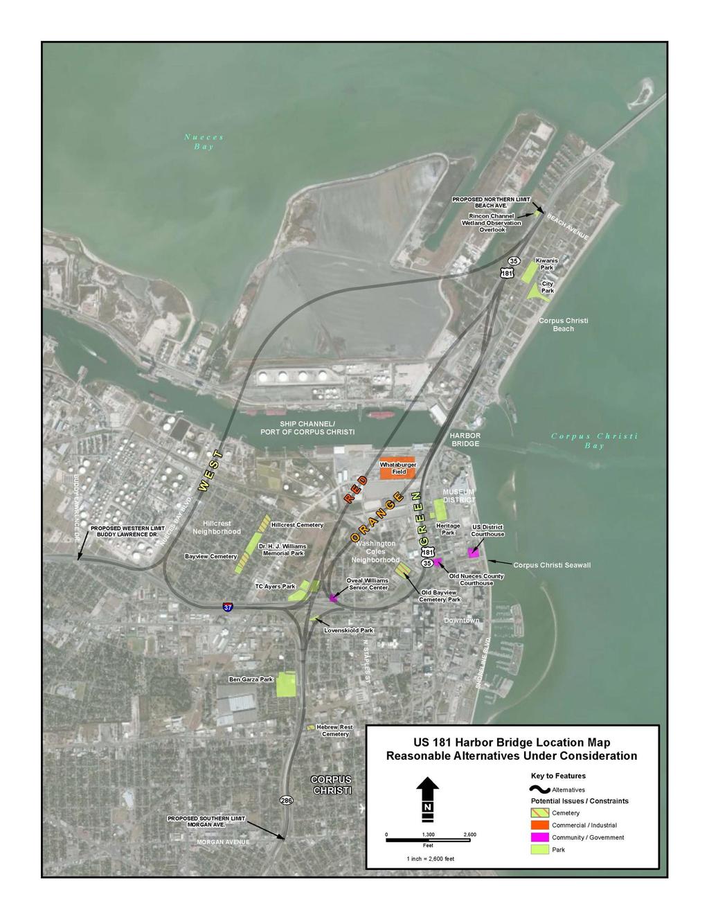
36 US Harbor Bridge Location Map Current Build Alternatives Under Consideration
37
38 Proposed Corpus Christi Ship Channel Improvements

39 Corpus Christi Ship Proposed Channel Improvements
Texas Department of Transportation Corpus Christi District
 Texas Department of Transportation Corpus Christi District U.S. 181 Harbor Bridge Project Environmental Documentation and Schematic Development Public Scoping Meeting August 9, 2011 Welcome John A. Casey,
8.0 PUBLIC INVOLVEMENT
 8.0 PUBLIC INVOLVEMENT Agency coordination and public involvement are crucial to the successful completion of transportation infrastructure projects. The Texas Department of Transportation (TxDOT) Corpus
SAFETEA-LU. Overview. Background
 SAFETEA-LU This document provides information related to the Safe, Accountable, Flexible, Efficient Transportation Equity Act: A Legacy for Users (SAFETEA-LU) that was previously posted on the Center for
Proposed Connector between Airline Highway (US 61) and Interstate 10 in St. John the Baptist Parish
 and Interstate 10 in St. John the Baptist Parish") DRAFT COORDINATION PLAN Proposed Connector between Airline Highway (US 61) and Interstate 10 in St. John the Baptist Parish OCTOBER 2, 2009 State Project No. 70-48-0101 Federal Aid No. HP-TO21(517) RPC
DRAFT COORDINATION PLAN Proposed Connector between Airline Highway (US 61) and Interstate 10 in St. John the Baptist Parish OCTOBER 2, 2009 State Project No. 70-48-0101 Federal Aid No. HP-TO21(517) RPC
Public Notice U.S. ARMY CORPS OF ENGINEERS, GALVESTON DISTRICT AND TEXAS COMMISSION ON ENVIRONMENTAL QUALITY
 Public Notice U.S. Army Corps Permit Application No: SWG-2012-00381 Of Engineers Date Issued: April 27, 2016 Galveston District Comments Due: May 30, 2017 U.S. ARMY CORPS OF ENGINEERS, GALVESTON DISTRICT
PUBLIC NOTICE Application for Permit
 PUBLIC NOTICE Application for Permit 30-Day Notice Issue Date: January 24, 2017 Expiration Date: February 22, 2017 US Army Corps of Engineers No: NWP-2007-5/2 Oregon Department of State Lands No: N/A Interested
Transportation Alternatives Program Application For projects in the Tulsa Urbanized Area
 FFY 2015-2016 Transportation Alternatives Program Application For projects in the Tulsa Urbanized Area A Grant Program of Moving Ahead for Progress in the 21st Century (MAP-21) U.S. Department of Transportation
Appendix E Federal and State Funding Categories
 Appendix E Federal and State Funding Categories This page left blank intentionally. Federal and State Funding Categories Appendix E E 3 Appendix E Federal and State Funding Categories Highway Programs
Public Notice U.S. ARMY CORPS OF ENGINEERS, GALVESTON DISTRICT AND TEXAS COMMISSION ON ENVIRONMENTAL QUALITY
 Public Notice U.S. Army Corps Permit Application No: SWG-2015-00306 Of Engineers Date Issued: 14 January 2016 Galveston District Comments Due: 16 February 2016 U.S. ARMY CORPS OF ENGINEERS, GALVESTON DISTRICT
TRANSPORTATION ALTERNATIVES (TA) SET ASIDE PROGRAM July 2016
 SET ASIDE PROGRAM July 2016") Regional Transportation Commission TRANSPORTATION ALTERNATIVES (TA) SET ASIDE PROGRAM July 2016 Contents 1.0 Purpose and Eligibility... 2 2.0 Process... 5 3.0 Implementation of Funded Projects... 5 Attachment
Regional Transportation Commission TRANSPORTATION ALTERNATIVES (TA) SET ASIDE PROGRAM July 2016 Contents 1.0 Purpose and Eligibility... 2 2.0 Process... 5 3.0 Implementation of Funded Projects... 5 Attachment
Draft Project Coordination Plan
 Draft Project Coordination Plan Environmental Impact Statement SH 68 from US 83/IH-2 to US 281/IH-69C CSJs: 3629-01-001, -002, -003 Hidalgo County, Texas Texas Department of Transportation Pharr District
July 5, JOINT PUBLIC NOTICE Savannah District/State of Georgia
 DEPARTMENT OF THE ARMY SAVANNAH DISTRICT, CORPS OF ENGINEERS 100 W. OGLETHORPE AVENUE SAVANNAH, GEORGIA 31401-3604 July 5, 2018 Regulatory Branch SAS-2015-00235 JOINT PUBLIC NOTICE Savannah District/State
National Capital Region Transportation Planning Board
 National Capital Region Transportation Planning Board 777 North Capitol Street, N.E., Suite 300, Washington, D.C. 20002-4290 (202) 962-3310 Fax: (202) 962-3202 Item #5 MEMORANDUM January 8, 2010 To: From:
Commonwealth Transportation Board Briefing
 Hampton Roads Crossing Study (HRCS) (SEIS) Commonwealth Transportation Board Briefing September 20, 2016 Angel Deem VDOT, Environmental Division Director HRCS History 1991: Federal funding allocated for
Transportation Alternatives Program (TAP) Recreational Trails Program (RTP)
 Recreational Trails Program (RTP)") Transportation Alternatives Program (TAP) Recreational Trails Program (RTP) www.fhwa.dot.gov/environment/transportation_alternatives/overview/presentation/ 1 Transportation Alternatives Program Authorized
Transportation Alternatives Program (TAP) Recreational Trails Program (RTP) www.fhwa.dot.gov/environment/transportation_alternatives/overview/presentation/ 1 Transportation Alternatives Program Authorized
NCDOT Planning Summary for NCTA Projects
 NCDOT Planning Summary for NCTA Projects Page 1 Triangle Expressway Southeast Extension Wake and Johnston Counties (STIP Projects R-2721, R-2828, and R-2829) The Triangle Expressway Southeast Extension
Final Supplemental Environmental Impact Statement APPENDIX C: COORDINATION PLAN
 TABLE 1: AGENCIES AND CONSULTING PARTIES Final Supplemental Environmental Impact Statement Role Federal Federal Tribes Virginia Local / Others Federal Highway Administration N/A N/A Lead Agency Transportation
Welcome to the Public Meeting for the State Highway 68 Project. SH 68 Project Office Information Environmental Constraints & Study Corridors
 Welcome to the Public Meeting for the State Highway 68 Project ENTRANCE EXIT Registration & Handouts Comment Card Area Welcome Video Next Steps Project History Information Environmental Constraints & Study
2. Transportation Alternatives Program Activities Regulations and Guidelines... 4, 5 & Eligible and Ineligible Items...
 FY 2018 TRANSPORTATION ALTERNATIVES PROGRAM INSTRUCTIONS, GUIDELINES AND APPLICATION TABLE OF CONTENTS Page(s) 1. Instructions for Submitting a Transportation Alternatives Program Application.. 1 2. Transportation
TEXAS MARITIME UPDATE
 TEXAS MARITIME UPDATE Texas Transportation Commission Workshop June 25, 2014 Texas Ports Tour First time the state has embarked on a statewide tour and formal indepth examination of Texas ports For some
Guidance. Historical Studies Review Procedures
 Guidance Historical Studies Review Procedures This guidance document provides instructional material regarding how to review and process project activities in accordance with TxDOT s Section 106 of the
PUBLIC PARTICIPATION PLAN
 0 PUBLIC PARTICIPATION PLAN GENERAL The City of Tyler currently serves as the fiscal agent for the Tyler Area Metropolitan Planning Organization (MPO), which represents the Tyler Metropolitan Study Area.
FFY Transportation Improvement Program
 Lawton Metropolitan Planning Organization DRAFT FFY 2018-2021 Transportation Improvement Program Approved, 2017 The Federal Fiscal Years (FFY) 2018-2021 Transportation Improvement Program (TIP) is updated
Welcome to the WebEx. The presentation for the 2019 Unified Transportation Program (UTP) Public Meeting will begin shortly.
 Public Meeting will begin shortly.") Welcome to the WebEx. The presentation for the 2019 Unified Transportation Program (UTP) Public Meeting will begin shortly. We will take questions after the presentation, however, you may enter questions
Welcome to the WebEx. The presentation for the 2019 Unified Transportation Program (UTP) Public Meeting will begin shortly. We will take questions after the presentation, however, you may enter questions
2013 Louisiana Transportation Conference
 February 20, 2013 Baton Rouge River Center 2013 Louisiana Transportation Conference Partnerships for Progress in Transportation Mega Projects Session (I-12 to Bush) I-12 to Bush Agenda Inclusion into TIMED
Module 2 Planning and Programming
 Module 2 Planning and Programming Contents: Section 1 Overview... 2-2 Section 2 Coordination with MPO... 2-4 Section 3 Functional Classification... 2-6 Section 4 Minute Order for Designation as Access
GENERAL ASSEMBLY OF NORTH CAROLINA SESSION 2013 SESSION LAW HOUSE BILL 484
 GENERAL ASSEMBLY OF NORTH CAROLINA SESSION 2013 SESSION LAW 2013-51 HOUSE BILL 484 AN ACT TO ESTABLISH A PERMITTING PROGRAM FOR THE SITING AND OPERATION OF WIND ENERGY FACILITIES. The General Assembly
STATE HIGHWAY (SH) 34 FEASIBILITY STUDY PUBLIC MEETING
 34 FEASIBILITY STUDY PUBLIC MEETING") STATE HIGHWAY (SH) 34 FEASIBILITY STUDY PUBLIC MEETING From FM 2578 in Terrell to SH 243 in Kaufman CSJ: 0173-04-056 June 28, 2018 WHAT IS A FEASIBILITY STUDY WHAT IS A FEASIBILITY STUDY? A feasibility
STATE HIGHWAY (SH) 34 FEASIBILITY STUDY PUBLIC MEETING From FM 2578 in Terrell to SH 243 in Kaufman CSJ: 0173-04-056 June 28, 2018 WHAT IS A FEASIBILITY STUDY WHAT IS A FEASIBILITY STUDY? A feasibility
Brownfields Conference Oklahoma City, OK May 22, What is FHWA?
 Brownfields Conference Oklahoma City, OK May 22, 2012 What is FHWA? 2 1 What does FHWA do? The Federal Highway Administration: Improves Mobility on the Nation s highways through National Leadership, Innovation
DEPARTMENT OF THE ARMY SAVANNAH DISTRICT, CORPS OF ENGINEERS 1104 NORTH WESTOVER BOULEVARD, UNIT 9 ALBANY, GEORGIA SEPT 1ER
 DEPARTMENT OF THE ARMY SAVANNAH DISTRICT, CORPS OF ENGINEERS 1104 NORTH WESTOVER BOULEVARD, UNIT 9 ALBANY, GEORGIA 31707 REPLY TO ATTENTION OF SEPT 1ER 1 1 2815 Regulatory Division SAS-2013-00942 JOINT
I-35W Bridge. Khani Sahebjam, PE. From Tragedy to Triumph. Vice President HDR Engineering, Inc. Former Deputy Commissioner/Chief Engineer MnDOT
 I-35W Bridge From Tragedy to Triumph Khani Sahebjam, PE Vice President HDR Engineering, Inc. Former Deputy Commissioner/Chief Engineer MnDOT History Bridge background Bridge completed 1967 1907 feet long
Scoping Report April 2018
 Scoping Report April 2018 TABLE OF CONTENTS 1.0 INTRODUCTION...1 1.1 Project Background... 1 2.0 PUBLIC SCOPING...3 2.1 Notice of Intent... 3 2.2 Website... 3 2.3 Public Scoping Meeting Notification...
Appendix B Review Matrix Text & Table Footnotes
 Review Submissions The PDP includes a series of review submissions designed to ensure that all projects are developed in accordance with ODOT policies. The PDP Products Review Matrix found in this Appendix
Fiscal Year 2014 TRANSPORTATION ALTERNATIVES PROGRAM (TAP) INSTRUCTIONS AND GUIDELINES
 INSTRUCTIONS AND GUIDELINES") Fiscal Year 2014 TRANSPORTATION ALTERNATIVES PROGRAM (TAP) INSTRUCTIONS AND GUIDELINES TABLE OF CONTENTS Pages 1. Instructions for Submitting a Transportation Alternatives Program Application. 1 2. Transportation
Fiscal Year 2014 TRANSPORTATION ALTERNATIVES PROGRAM (TAP) INSTRUCTIONS AND GUIDELINES TABLE OF CONTENTS Pages 1. Instructions for Submitting a Transportation Alternatives Program Application. 1 2. Transportation
2017 Nationwide Permit Reissuance
 2017 Nationwide Permit Reissuance Seattle District, U.S. Army Corps of Engineers 14 December 2015 Tribal Coordination Meeting 1 Seattle District s Limits of Regulatory Jurisdiction Northwest Field Office
COORDINATION PLAN. September 30, 2011
 COORDINATION PLAN September 30, 2011 TABLE 1: AGENCIES AND CONSULTING PARTIES Role Federal Agencies Virginia Agencies Local Agencies / Others Lead Agency Federal Highway Administration (FHWA) Transportation
REQUEST FOR INFORMATION
 REQUEST FOR INFORMATION REGARDING THE DEVELOPMENT OF AND PROCUREMENT PROCESS FOR THE GRAND PARKWAY PROJECT TEXAS DEPARTMENT OF TRANSPORTATION RFI Issuance Date: June 10, 2011 RFI Closing Date: July 6,
Appendix F Public Meeting Summaries. F1: May 2013 Public Meeting Summary F2: September 2013 Public Meeting Summary
 Loop 9 Southeast Corridor/Feasibility Study Appendix F Public Meeting Summaries F1: May 2013 Public Meeting Summary F2: September 2013 Public Meeting Summary Loop 9 Southeast Corridor/Feasibility Study
WORK SESSION ITEM City Council
 DATE: STAFF: October 25, 2016 Mark Jackson, PDT Deputy Director WORK SESSION ITEM City Council SUBJECT FOR DISCUSSION I-25 Northern Colorado Improvements. EXECUTIVE SUMMARY The purpose of this item is
PUBLIC NOTICE. Section 404 of the Clean Water Act (33 U.S.C. 1344) Section 10 of the Rivers and Harbors Act of 1899 (33 U.S.C.
 Section 10 of the Rivers and Harbors Act of 1899 (33 U.S.C.") US Army Corps Of Engineers Wilmington District PUBLIC NOTICE Issue Date: March 1, 2018 Comment Deadline: April 2, 2018 Corps Action ID Number: SAW-2011-02228 The Wilmington District, Corps of Engineers
US Army Corps Of Engineers Wilmington District PUBLIC NOTICE Issue Date: March 1, 2018 Comment Deadline: April 2, 2018 Corps Action ID Number: SAW-2011-02228 The Wilmington District, Corps of Engineers
PUBLIC NOTICE. Attn: Mr. Christopher Layton 1200 Duck Road Duck, North Carolina CB&I 4038 Masonboro Loop Road Wilmington, North Carolina 28409
 US Army Corps Of Engineers Wilmington District PUBLIC NOTICE Issue Date: January 15, 2015 Comment Deadline: February 16, 2015 Corps Action ID Number: SAW-2014-02202 The Wilmington District, Corps of Engineers
COORDINATION PLAN. As of November 14, 2011
 As of November 14, 2011 TABLE 1 SUMMARY OF AGENCY ROLES Agency Role Federal Agencies Virginia Agencies Local Agencies Lead Agencies Federal Highway Administration () Virginia Department of Transportation
AGC of TEXAS Highway, Heavy, Utilities & Industrial Branch
 AGC of TEXAS Highway, Heavy, Utilities & Industrial Branch THOMAS L. JOHNSON, Executive Vice President Texas Transportation Commission Meeting Highlights September 18 and 24, 2014 September 18 Commissioner
PUBLIC NOTICE Application for Permit
 PUBLIC NOTICE Application for Permit 30-Day Notice Issue Date: February 17, 2017 Expiration Date: March 20, 2017 US Army Corps of Engineers No: NWP-2017-53 Oregon Department of State Lands No: APP0059783
South Dakota Transportation Alternatives
 South Dakota Transportation Alternatives Program Summary and Application Guide Updated March 2018 Connecting South Dakota and the Nation 1 Transportation Alternatives (TA) Summary 1. Overview Transportation
Purpose. Funding. Eligible Projects
 SMART SCALE is a statewide program that distributes funding based on a transparent and objective evaluation of projects that will determine how effectively they help the state achieve its transportation
Appendix C: Public Participation
 Appendix C: Public Participation TABLE OF CONTENTS APPENDIX C PUBLIC PARTICIPATION... C-1 C.1 PROJECT WEBSITE... C-1 C.2 GENERAL SUMMARY OF THE SCOPING PERIOD... C-1 C.2.1 TRIBAL NOTIFICATION LETTERS...
Appendix 5 Freight Funding Programs
 5. Chapter Heading Appendix 5 Freight Programs Table of Contents 4.1 Surface Transportation Block Grant (STBG);... 5-1 4.2 Transportation Investment Generating Economic Recovery Discretionary Grant Program
Mark A. Doctor, PE CAREER PATH
 Mark A. Doctor, PE Professional Profile A career of over 27 years with the Federal Highway Administration in various transportation engineering positions with diverse experiences and accomplishments in
PROJECT SELECTION Educational Series
 PROJECT SELECTION 2017 Educational Series PROJECT SELECTION THE PROJECT SELECTION PROCESS Understanding how the state s roads, bridges and other transportation infrastructure are selected for funding helps
Transportation Alternatives (TA) Northeast Minnesota Workshop
 Northeast Minnesota Workshop") Transportation Alternatives (TA) Northeast Minnesota Workshop October 4 th, 2016 1 What are TA Projects? Federally funded community based projects o Expand travel choices o Integrate modes o Improve cultural,
Transportation Alternatives (TA) Northeast Minnesota Workshop October 4 th, 2016 1 What are TA Projects? Federally funded community based projects o Expand travel choices o Integrate modes o Improve cultural,
PUBLIC NOTICE.
 US Army Corps Of Engineers Wilmington District PUBLIC NOTICE Issue Date: January 19, 2017 Comment Deadline: February 17, 2017 Corps Action ID Number: SAW-2011-01243 The Wilmington District, Corps of Engineers
Anchorage Grounds; Galveston Harbor, Bolivar Roads Channel, Galveston, Texas
 This document is scheduled to be published in the Federal Register on 04/27/2018 and available online at https://federalregister.gov/d/2018-08873, and on FDsys.gov 9110-04-P DEPARTMENT OF HOMELAND SECURITY
SUNIGA/LEMAY MULTI-MODAL AND FREIGHT CONNECTIVITY PROJECT
 June 4, 2015 Existing Condition Improved Condition Table of Contents APPLICATION LETTER...i EXECUTIVE SUMMARY...1 A. PROJECT DESCRIPTION...4 B. PROJECT LOCATION...6 C. PROJECT PARTIES...9 D. GRANT FUNDS
Gulf Intracoastal Waterway
 TEXAS DEPARTMENT OF TRANSPORTATION Gulf Intracoastal Waterway 2003-2004 Legislative Report Texas Department of Transportation Dewitt C. Greer State Highway Bldg. 125 E. 11th Street Austin, Texas 78701-2483
Transportation Improvement Program for Lake, Porter, and LaPorte Counties, Indiana for
 Transportation Improvement Program for Lake, Porter, and LaPorte Counties, Indiana for 2012-2015 Part II: TIP Development and Project Selection Processes MPO Planning Process The NIRPC Board of Commissioners
Wisconsin DNR Administered Programs. Aids For The Acquisition And Development Of Local Parks (ADLP)
") Wisconsin DNR Administered Programs Community Service Specialist Rhinelander Service Center 107 Sutliff Ave Rhinelander WI 54501 Acquisition Of Development Rights Grants (ADR) Helps to buy development
Wisconsin DNR Administered Programs Community Service Specialist Rhinelander Service Center 107 Sutliff Ave Rhinelander WI 54501 Acquisition Of Development Rights Grants (ADR) Helps to buy development
TRANSPORTATION FUNDING PROGRAMS
 APPENDIX A Note: Not yet edited by DCPD. TRANSPORTATION FUNDING PROGRAMS 6 Transportation Funding Programs The following provides a brief description of transportation related funding programs that are
APPENDIX A PROGRAMMATIC AGREEMENT FOR MINOR TRANSPORTATION PROJECTS
 APPENDIX A PROGRAMMATIC AGREEMENT FOR MINOR TRANSPORTATION PROJECTS PROGRAMMATIC AGREEMENT AMONG THE FEDERAL HIGHWAY ADMINISTRATION THE PENNSYLVANIA DEPARTMENT OF TRANSPORTATION, THE PENNSYLVANIA STATE
CALVERT - ST. MARY S METROPOLITAN PLANNING ORGANIZATION
 CALVERT - ST. MARY S METROPOLITAN PLANNING ORGANIZATION TRANSPORTATION IMPROVEMENT PROGRAM FISCAL YEARS 2015-2018 Calvert County Planning Commission St. Mary s County Department of County Services Plaza
Capital District September 26, 2017 Transportation Committee. The Community and Transportation Linkage Planning Program for
 Capital District September 26, 2017 Transportation Committee The Community and Transportation Linkage Planning Program for 2018-19 Introduction The Community and Transportation Linkage Planning Program
In-Step, In Line, On Time. Robert F. Tally Jr. FHWA Indiana Division Administrator Monday, November 16, 2009
 In-Step, In Line, On Time Robert F. Tally Jr. FHWA Indiana Division Administrator Monday, November 16, 2009 I-69 Corridor 1 I-69 Corridor I-69 is expected to create more than 27,000 new jobs by 2025, resulting
AMERICA BIKES SIDE-BY-SIDE COMPARISON OF BICYCLE AND PEDESTRIAN PROGRAMS SAFETEA LU VS. MAP 21
 AMERICA BIKES SIDE-BY-SIDE COMPARISON OF BICYCLE AND PEDESTRIAN PROGRAMS SAFETEA LU VS. MAP 21 SAFETEA LU PROGRAMS 2012 MAP-21 PROGRAMS ANALYSIS 3 Distinct programs with their own funding, and mechanics
DEPARTMENT OF TRANSPORTATION. Notice of Intent to Prepare Environmental Impact Statement, I-495 & I-270 Managed
 This document is scheduled to be published in the Federal Register on 03/16/2018 and available online at https://federalregister.gov/d/2018-05354, and on FDsys.gov DEPARTMENT OF TRANSPORTATION [4910-22-P]
Coordination Plan for Agency and Public Involvement
 Coordination Plan for Agency and Public Involvement Prepared Pursuant to SAFETEA-LU Section 6002/ 23 USC 139(g) and formally 42 USC 4332 (2)(c) and 49 USC 303, 16 USC 470 (f) and 33 USC 1344 Newington-Dover
Topics Covered. Introduction Historic Perspective. Transportation. National Highway Bridge Program Challenges and Opportunities in Bridge Engineering
 Roles and Responsibilities of the Federal Highway Administration (FHWA) MMitL M. Myint Lwin, Director FHWA Office of Bridge Technology U.S. Department of Transportation Washington, DC Topics Covered Introduction
I-69 Corridor Segment Committee 1 and 2 Kick-off Meeting April 15 Nacogdoches, Texas
 I-69 Corridor Segment Committee 1 and 2 Kick-off Meeting April 15 Nacogdoches, Texas 10:00 a.m. Welcome/ Introductions Mark Tomlinson Division Dir., Texas Turnpike Authority Div, TxDOT 10:15 a.m. Presentations
DEPARTMENT OF THE ARMY SAVANNAH DISTRICT, CORPS OF ENGINEERS 100 WEST OGLETHORPE AVENUE SAVANNAH, GEORGIA
 DEPARTMENT OF THE ARMY SAVANNAH DISTRICT, CORPS OF ENGINEERS 100 WEST OGLETHORPE AVENUE SAVANNAH, GEORGIA 31401-3640 REPLY TO ATIENTlON OF APRIL 1 1 ZOlL Regulatory Division SAS-1998-03830 JOINT PUBLIC
ROUTE 52 CAUSEWAY REPLACEMENT PROJECT STEERING COMMITTEE MEETING NO. 5 REPORT
 STEERING COMMITTEE MEETING NO. 5 REPORT DATE: November 11, 2004 TIME: 10:00 a.m. 2:00 p.m. LOCATION: Office of Michael Baker, Jr., Princeton, NJ - Conference Room ATTENDEES: REPRESENTING: PHONE: Carol
Implementation. Implementation through Programs and Services. Capital Improvements within Cambria County
 The transportation system serves Cambria County communities because people make decisions and take action toward the stated goals of the long-range transportation plan. Locally, these people include officials
Appendix E Major Stakeholder Meeting Summaries. E1: Ash Grove Cement Company E2: Holcim E3: UPRR E3: BNSF E4: IIIPOD E5: Skyline Landfill E6: Oncor
 Loop 9 Southeast Corridor/Feasibility Study Appendix E Major Stakeholder Meeting Summaries E1: Ash Grove Cement Company E2: Holcim E3: UPRR E3: BNSF E4: IIIPOD E5: Skyline Landfill E6: Oncor Loop 9 Southeast
PUBLIC NOTICE Application for Permit
 PUBLIC NOTICE Application for Permit 30-Day Notice Issue Date: April 19, 2016 Expiration Date: May 19, 2016 US Army Corps of Engineers No: NWP-2014-37/2 Oregon Department of State Lands No: 56882-RF Interested
REQUEST FOR INFORMATION
 REQUEST FOR INFORMATION OKLAHOMA TURNPIKE AUTHORITY GILCREASE EXPRESSWAY RFI Issue Date: January 2, 2018 RFI Response Due Date: January 31, 2018 The Oklahoma Turnpike Authority ( Authority ) is seeking
SUMMARY OF THE GROW AMERICA ACT As Submitted to Congress on April 29, 2014
 SUMMARY OF THE ACT As Submitted to Congress on April 29, 2014 The U.S. Department of Transportation (USDOT) submitted the Generating Renewal, Opportunity, and Work with Accelerated Mobility, Efficiency,
2007 Annual List of Obligated Projects
 This document is available in accessible formats when requested five days in advance. This document was prepared and published by the Memphis Metropolitan Planning Organization and is prepared in cooperation
Transportation Alternatives Program Guidance & Application Packet Call for Projects: April 5 th, 2018 May 11 th, 2018
 Transportation Alternatives Program Guidance & Application Packet Call for Projects: April 5 th, 2018 May 11 th, 2018 Introduction The Region 1 Planning Council, in its capacity as the Metropolitan Planning
Megan P. Hall, P.E. Local Programs Engineer. Federal Highway Administration Washington Division. March 14, 2017
 Megan P. Hall, P.E. Local Programs Engineer Federal Highway Administration Washington Division March 14, 2017 1 Transportation Alternatives (TA) Recreational Trails Program (RTP) www.fhwa.dot.gov/environment/transportation_alternatives/overview/presentation/
Request for Qualifications For
 D E L A W A R E V A L L E Y R E G I O N A L P L A N N I N G C O M M I S S I ON The ACP Building, 190 N. Independence Mall West Telephone: (215) 592-1800 Philadelphia, PA 19106-1520 FAX: (215) 592-9125
MAP-21 and Its Effects on Transportation Enhancements
 Date: July 13, 2012 Subject: MAP-21 and Its Effects on Transportation Enhancements The recently enacted Moving Ahead for Progress in the 21 st Century (MAP-21) includes a number of substantial changes
INDIAN RIVER COUNTY METROPOLITAN PLANNING ORGANIZATION
 2016 PRIORITY PROJECTS REPORT INDIAN RIVER COUNTY METROPOLITAN PLANNING ORGANIZATION This document was produced in cooperation with the Florida Department of Transportation and the Federal Highway Administration
Transportation Planning Policy Manual
 Transportation Planning Policy Manual September 2001 Transportation Planning Policy Manual September 2001 Manual Notices Manual Notice 2001-1 To: From: Manual: Districts, Divisions and Offices Kirby W.
Scope of Services for Environmental Assessment for Projects
 Scope of Services for Environmental Assessment for Projects The Consultant shall submit a Scope and Fee for completion of all required studies, and final documentation in compliance with the National Environmental
Massachusetts Department of Transportation (MassDOT) Route 3 South Managed Lanes Project DRAFT FOR DISCUSSION PURPOSES ONLY
 Route 3 South Managed Lanes Project DRAFT FOR DISCUSSION PURPOSES ONLY") Massachusetts Department of Transportation (MassDOT) Project High Level P3 Project Suitability Assessment Report September 11, 2013 Contents Proposed Project Description Project Background and Status Commonwealth
Massachusetts Department of Transportation (MassDOT) Project High Level P3 Project Suitability Assessment Report September 11, 2013 Contents Proposed Project Description Project Background and Status Commonwealth
RESOLUTION FOR APPROVAL OF AMENDMENTS TO THE TRANSPORTATION IMPROVEMENT PROGRAM (TIP) AND 2040 REGIONAL TRANSPORTATION PLAN (RTP)
 AND 2040 REGIONAL TRANSPORTATION PLAN (RTP)") TPC Agenda Item 6A Mailout 10/20/16 RESOLUTION FOR APPROVAL OF AMENDMENTS TO THE 2017-2020 TRANSPORTATION IMPROVEMENT PROGRAM (TIP) AND 2040 REGIONAL TRANSPORTATION PLAN (RTP) Amendment Summary Amendment
TPC Agenda Item 6A Mailout 10/20/16 RESOLUTION FOR APPROVAL OF AMENDMENTS TO THE 2017-2020 TRANSPORTATION IMPROVEMENT PROGRAM (TIP) AND 2040 REGIONAL TRANSPORTATION PLAN (RTP) Amendment Summary Amendment
Arkansas Transportation Alternatives Program (TAP-2015) & Recreational Trails Program (RTP-2015) Application Seminars
 & Recreational Trails Program (RTP-2015) Application Seminars") Arkansas Transportation Alternatives Program (TAP-2015) & Recreational Trails Program (RTP-2015) Application Seminars January 22, 2015 & February 19, 2015 Program History Guidelines Eligibility Application
Arkansas Transportation Alternatives Program (TAP-2015) & Recreational Trails Program (RTP-2015) Application Seminars January 22, 2015 & February 19, 2015 Program History Guidelines Eligibility Application
CORPUS CHRISTI METROPOLITAN PLANNING ORGANIZATION TECHNICAL ADVISORY COMMITTEE NOTES
 CORPUS CHRISTI METROPOLITAN PLANNING ORGANIZATION TECHNICAL ADVISORY COMMITTEE NOTES July 18, 2013 1. CALL TO ORDER AND QUORUM DETERMINATION Meeting called to order by Mr. Sullivan at 9:00 a.m. Quorum:
2018 Regional Project Evaluation Criteria For PSRC s FHWA Funds
 2018 Regional Project Evaluation Criteria For PSRC s FHWA Funds INTRODUCTION As described in the adopted 2018 Policy Framework for PSRC s Federal Funds, the policy focus for the 2018 project selection
Moving Ahead for Progress in the 21 st Century (MAP-21)
") Moving Ahead for Progress in the 21 st Century (MAP-21) Transportation Alternatives Program (TAP) ATP 6 Discussion June 28, 2013 Minnesota Overview: MAP-21 vs. SAFETEA-LU Overall apportionment consistent
Moving Ahead for Progress in the 21 st Century (MAP-21) Transportation Alternatives Program (TAP) ATP 6 Discussion June 28, 2013 Minnesota Overview: MAP-21 vs. SAFETEA-LU Overall apportionment consistent
KYOVA Interstate Planning Commission
 KYOVA Interstate Planning Commission Sub-allocated Funding Process and Application Package This packet includes information and guidance about the process used by KYOVA Interstate Planning Commission to
MEMORANDUM OF AGREEMENT BETWEEN THE FLORIDA DEPARTMENT OF ENVIRONMENTAL PROTECTION AND THE UNITED STATES ENVIRONMENTAL PROTECTION AGENCY
 ***DRAFT DELIBERATIVE. DO NOT RELEASE UNDER FOIA. NOTHING CONTAINED HEREIN SHALL BE CONSTRUED AS CREATING ANY RIGHTS OR BINDING EITHER PARTY*** MEMORANDUM OF AGREEMENT BETWEEN THE FLORIDA DEPARTMENT OF
Transportation Planning in the Denver Region
 The Prospectus Transportation Planning in the Denver Region TAC Draft (as of June 16, 2011) Approved December 2004 Revised November 2006 Revised August 2007 Revised March 2009 Revised 2011 Key revisions
ENVIRONMENTAL ASSESSMENTS. Classification & Documentation
 ENVIRONMENTAL ASSESSMENTS Classification & Documentation CLASSIFICATION What s an Environmental Assessment? Not a Categorical Exclusion (CE) Not an Environmental Impact Statement (EIS) 3 Classification
VALUE ENGINEERING PROGRAM
 Approved: Effective: May 17, 2017 Review: March 30, 2017 Office: Production Support Office Topic No.: 625-030-002-i Department of Transportation PURPOSE: VALUE ENGINEERING PROGRAM To provide a consistent
Security Zones; Naval Base Point Loma; Naval Mine Anti Submarine. SUMMARY: The Coast Guard is increasing a portion of an existing
 This document is scheduled to be published in the Federal Register on 12/02/2013 and available online at http://federalregister.gov/a/2013-28035, and on FDsys.gov 9110-04-P DEPARTMENT OF HOMELAND SECURITY
MAP-21: Overview of Project Delivery Provisions
 MAP-21: Overview of Project Delivery Provisions This paper provides an overview of the project delivery provisions in the Moving Ahead for Progress in the 21st Century Act (MAP-21). It also briefly summarizes
U.S. Army Corps of Engineers Navigation Program Update
 U.S. Army Corps of Engineers Navigation Program Update For California Marine Affairs and Navigation Conference Jeffrey A. McKee Chief, Navigation Branch US Army Corps of Engineers March 10, 2015 US Army
HOW DOES A PROJECT GET INTO THE STIP?
 HOW DOES A PROJECT GET INTO THE STIP? The Statewide Transportation Improvement Program, known as the STIP, is a list that shows prioritization, funding, and scheduling of transportation projects and programs
Welcome to the WebEx. The presentation for the 2018 Unified Transportation Program (UTP) Public Meeting will begin shortly.
 Public Meeting will begin shortly.") Welcome to the WebEx. The presentation for the 2018 Unified Transportation Program (UTP) Public Meeting will begin shortly. We will take questions after the presentation, however, you may enter questions
Welcome to the WebEx. The presentation for the 2018 Unified Transportation Program (UTP) Public Meeting will begin shortly. We will take questions after the presentation, however, you may enter questions
SMALL CITY PROGRAM. ocuments/forms/allitems.
 SMALL CITY PROGRAM The Small City Program provides Federal funds to small cities with populations from 5,000 to 24,999 that are NOT located within Metropolitan Planning Organizations' boundaries. Currently
NATIONAL CAPITAL REGION TRANSPORTATION PLANNING BOARD 777 North Capitol Street, N.E. Washington, D.C
 NATIONAL CAPITAL REGION TRANSPORTATION PLANNING BOARD 777 North Capitol Street, N.E. Washington, D.C. 20002 TPB SR22-2017 May 5, 2017 RESOLUTION ON AN AMENDMENT TO THE FY 2017-2022 TRANSPORTATION IMPROVEMENT