DRAFT. Merced Vision 2030 General Plan
|
|
|
- Damian Barker
- 5 years ago
- Views:
Transcription
1
2
3
4


5 DRAFT Merced Vision 2030 General Plan August 2010 EXHIBIT A OF ATTACHMENT 15
6 MERCED VISION 2030 GENERAL PLAN OPTION 3 Proposed Changes Since August 2010 Public Review Draft (*Revised--10/4/2011) Abbreviations: Sources: Pg = Page # BAC = Bicycle Advisory Committee = Paragraph # BIA = Building Industry Association Col. = Column = City Council R = Right Column CL = Citizen Letter (Various) L = Left Column CO = County Planning Staff = City Staff (Planning, City Attorney, etc.) EDAC = Economic Development Advisory Committee EIR = Changes proposed in Final EIR for the General Plan = Fire Chief (Appointed in 2011) GP LU Map = General Plan Land Use Diagram (Fig. 3.1) GPA = General Plan Amendment (approved since GP LU Map was drafted) LF = LAO Staff PC = Planning Commission TYPO = Typographic Error UC = University of California Staff Entire Document # Pg. Col. Change Source Various Figures, Maps, and Table throughout the General Plan document will be modified to reflect the 2009 UC Merced and University Community North boundaries as adopted by the UC Board of Regents in This will include changes to the Land Use Diagram and SUDP/SOI boundary for those areas only. See Exhibit 1 for the 2009 UC/UCP boundaries. /UC EXHIBIT B--Page 1 (Option 3)
7 Executive Summary # Pg. Col. Change Source 2 I-ii 2 L 2 nd sentence should read: The seven required elements are land use, transportation, circulation, open space, conservation, housing, noise, and safety. 3 I-ii 4 L Last sentence should read: It presents the general distribution of the uses of land within the City of Merced and its Specific Urban Development Plan/Sphere of Influence (SUDP/SOI), or growth boundary. 4 I-v 1 R 1 st sentence should read: The Merced Vision General Plan TYPO is organized 5 I-xi 9 R The italics should be removed from the entire sentence. TYPO 6 II-xiii Under Goal Area S-3: Flooding, Policy S-3.1 should read: S-3.1 Implement Protective Measures for Areas in the City and the SUDP/SOI Within the 100-Year and 200-Year Floodplains. (Needs to match text on pg ). Chapter 1--Introduction # Pg. Col. Change Source R Text in 1 st sentence noted in ALL CAPS 67 OPS.CAL.ATTY. GEN.75 should read 67.Ops.Cal.Att.Gen.75 instead. Chapter 2--Urban Expansion # Pg. Col Change Source L Last sentence should read: County policies that also affect the rural and suburban areas immediately outside the City s incorporated limits R The 1 st sentence of the 4 th paragraph should read: The Land Use Diagram will accommodate a population larger than what is projected in Table 2.1.a, which reflects projections done by the Merced County Association of Governments in 2004, and includes the projected population for the City of Merced and its SUDP/SOI along with the UC Merced campus and University Community. MCAG provides separate population projections for the UC area, which are included in the City s SUDP/SOI numbers in Table 2.1. (The 2030 population number was subsequently reduced from 154, 961 to 137,779 by MCAG in July 2010 when new population projections were adopted. A 2035 population projection of 152,100 was also added. A new Table 2.1.b has been added to show the July 2010 population projections for both the City and UC Merced/University Community as well as Merced County.) EXHIBIT B--Page 2 (Option 3)
8 # Pg. Col Change Source Under Table 2.1.a, City of Merced Population Projections (2000 to 2030), which has been re-titled Table 2.1.a, the following should be added: Source: Merced County Association of Governments, Under Table 2.1.a, a new Table 2.1.b, City of Merced Population Projections ( ) should be added (see Exhibit 2) Implementing Action UE-1.2.c should read as follows: Continue to limit expansion of City utilities to only those areas within an the established urban boundary Under the explanation under Implementing Action UE-1.2.c, after the 3 rd sentence, the following should be added: If it is necessary for technical/economic reasons to allow utilities to cross unincorporated territory (i.e. water/sewer main extensions), actual access to such utility services will be restricted to those inside the City limits until such time as annexation occurs Under the explanation for Implementing Action UE-1.2.d, the 2 nd sentence should read as follows: The highest densities should, in general, be directed toward central areas of the City and not along the urban fringes unless they are in Community Plan areas, where higher densities may be justified Under Implementing Action UE-1.3.g, in the explanation section following the Action itself, should read: a) Urban Expansion Policies UE 1.1, UE 1.2, and UE 1.3., and UE In the explanation under Implementing Action UE-1.5.d, the following should be added after the 2 nd sentence: The City will consider establishing a Rural Residential (R-R) zoning district, which can be used in these areas upon annexation. The R-R district would address standards for existing private wells and septic systems, the keeping of animals and livestock, the level of public improvements in such areas (i.e. the possible omission of sidewalks, etc.), and other issues that often arise when such developed areas are proposed for annexation. CL CL CL EXHIBIT B--Page 3 (Option 3)
9 Chapter 3--Land Use # Pg. Col. Change Source L Text in the 3 rd sentence noted in ALL CAPS 67 OPS.CAL.ATTY. GEN.75 should read 67.Ops.Cal.Att.Gen.75 instead Table 2.1 Merced Planned Land Use Summary will be modified as shown in Exhibit R In the 1 st sentence, duplexes should NOT be italicized. TYPO L The title above the 2 nd paragraph should read: P/G or SCH (Public/Government or School) L The 2 nd sentence shall be revised to read: TYPO OS-PK areas may be designated in areas containing public parks, golf courses, greens, commons, playgrounds, landscape areas and similar types of public and public private open spaces L Last sentence should read The City of Merced Housing Element (Chapter 9) was adopted last revised in 2004 and will be updated in Under Implementing Action L-1.4.b, the 1 st sentence of the explanation under the Action should read: In 2010, the City of Merced currently has a significant inventory of over 2,000 2,500 lots, which are within approved subdivisions but have not yet been built on Under Implementing Action L-1.4.b, the 2nd sentence of the explanation under the Action should read: In addition, the City has significant numbers of foreclosed homes. (i.e. Merced has for the last few years, consistently lead the nation in the number of foreclosures). {Note: The information in ( ) was somewhat misleading as the foreclosure stats refer to Merced County and not the City of Merced, so staff recommends deleting it since the first part of the sentence makes the point on its own.} Under Implementing Action L-1.4.b, the 3rd sentence of the explanation under the Action should read: The City should consider developing incentives to spur the development of these undeveloped lots, including reduced development fees for in-fill areas and expedited processing of development applications for construction on in-fill lots in addition to reviewing the City s current annexation policies to make sure such in-fill development is favored over new Greenfield development in outlying areas. (The above was suggested by Commissioner Colby at the Joint PC/ Study Session on 1/10/11. Not all of his suggested language was supported by the other members, but there seemed to be agreement on the additions above.) PC EXHIBIT B--Page 4 (Option 3)
10 # Pg. Col Change Source Under Implementing Action L-2.2.d, last sentence of explanation TYPO following the Action should read: Special attention should be given to areas within the northwestern northeastern portion of the City as job centers for businesses seeking a location near UC Merced The 1 st sentence of the 3 rd paragraph of the explanation under EDAC 3-50 Implementing Action L-2.7.a should read: Although the City believes that new commercial centers should not ideally be located at the corner of two arterials, the City might will consider extremely limited exceptions for largescale (minimum 20 acres), high quality projects which agree to abide by strict access and land use restrictions in proximity to the intersection (rest of sentence remains the same) Implementing Action L-2.9.a should read: TYPO Plan for job centers in the northwestern northeastern portion of the City capitalizing on the proximity of a research university, UC Merced. 1 st sentence of explanation under L-2.9.a should read: As part of the development of the northwestern northeastern area, research and development campuses should be encouraged After the last sentence of the explanation under Implementing CL Action L-2.9.a, the following should be added: Business parks to accommodate research and development, technology, light industry, and business uses complimentary of the UC Merced Campus research could also be located on appropriately-designated properties along the Bellevue Corridor and other transportation corridors in the vicinity of the UC Merced Campus if the market exists for such uses In the explanation under Implementing Action L-3.6.b, No. 2 TYPO should read: 2) Community Plans which include or are adjacent to established neighborhoods will address the needs of those neighbor-hoods neighborhoods and potential adverse impacts resulting from plan implementation In the explanation under Implementing Action L-3.6.b, No. 4 BAC should read: 4) Community Plan areas need connectivity with existing and planned urban areas. This includes all modes of transportation, including vehicles, bicycles, public transit, etc In the explanation under Implementing Action L-3.6.b, the last paragraph should read as follows: The City shall may undertake the development of these Community Plans subsequent to the adoption of the General Plan or require developers to complete such plans. The costs of developing the plans may be assessed to those property owners, builders, and developers who will benefit from the plans as development takes place. EXHIBIT B--Page 5 (Option 3)
11 # Pg. Col Change Source L The 1 st sentence should read: The Specific Plans do not necessarily conform with the requirements of may or may not be a specific plan as contemplated by Government Code Section et seq L 1 st sentence should read: As envisioned in this plan, a Community Plan may or may not conform with meet the requirements of a specific plan contemplated by Government Code Section et seq. for Specific Plans R The 2 nd sentence of No. 6 of Community Plan Guiding Principles should read: These elements may include but not be limited to Land Use, Circulation (including all modes of transportation), Open Space, and infrastructure phasing L The 1 st and 2 nd sentences should read: The City shall may undertake the development of these Community Plans subsequent to the adoption of the General Plan or require developers to complete such plans. The costs of developing the plans may be assessed to those property owners, builders, and developers who will benefit from the plans as development takes place L The 3 rd paragraph shall read as follows: Unlike the other Community Plans discussed in this Section, the University Community Plan (UCP) has already been adopted by Merced County. The City s 1997 Sphere of Influence currently includes the UC Merced Campus, although the Campus footprint has been revised since and tthe City of Merced assumes implementation of the a Revised University Community Plan UCP at some future date R The 2 nd paragraph should read as follows: In , the Merced County Board of Supervisors adopted the University Community Plan UCP (also called a Specific Urban Development Plan or SUDP ) and associated environmental impact report for the development of an adjacent university community. In 2004, when the SUDP was adopted by the County of Merced, the University Community Plan UCP covered 2,133 acres and consisted of high-, medium-, and lowdensity housing; commercial buildings; buildings to house research and development; and parking, parks, schools, and open space R The 1 st sentence of the 3 rd paragraph should read: The 2004 University Community Plan (UCP) has been adopted as part of the Merced County General Plan and includes goals, objectives, policies, and implementation programs to address the development of the University Community. BAC /CL UC/ EIR UC/ EIR UC/ EIR EXHIBIT B--Page 6 (Option 3)
12 # Pg. Col Change Source R The paragraph that follows the header Current Revisions Under & 3-72 & 1 & L Consideration should read as follows and the header should be modified to read 2009 Revisions : After the 2002 adoption of the LRDP, UC Merced applied for a CWA Section 404 permit to fill approximately 86 acres of wetlands on the campus site. During discussions with various federal agencies, the University is proposing proposed an alternative to reduce the Campus impacts on wetlands by reducing the size of the developed portion of the Campus from 910 acres to 810 acres and shifting the Campus boundary south into an area that was to be occupied by the University Community and shifting the Community boundary east. This proposed change brought about the need to revise the UC Merced LRDP and the University Community Plan, for which UC Merced officials prepared applications and an associated EIR, adopted by the University of California Board of Regents in Now Merced County will review the proposed change to the University Community Plan based on principles and objectives of the University Community Plan adopted in After that adoption, the University Board of Regents had indicated that it intended to submit an application for a University Community Plan Update to Merced County, which has land use jurisdiction over the University Community. Although this application has not yet been submitted to the County, the City of Merced has chosen to acknowledge the revised 2009 boundaries for the University and the University Community North within the Merced Vision 2030 General Plan since the environmental impacts of those boundaries have been fully analyzed in UC s EIR, which involved the participation of the University, the County of Merced, and the City of Merced L After the 1 st bullet under the heading Economics/Market, the following paragraph should be added: Project specific market studies may be provided by individual landowners in support of development proposals as an adjunct to and in support of the overall Bellevue Corridor market study. Individual landowners providing a project level market study showing support for planned land uses/activities may not be required to participate in the overall Bellevue Corridor market study after an evaluation of the project level study is completed by staff and deemed to be adequate to substitute for the overall Bellevue Corridor market study. CL EXHIBIT B--Page 7 (Option 3)
13 # Pg. Col Change Source L After the two bullets at the top of the page under CL Character/Design, the following paragraph should be added under a new heading entitled Timing : Development projects may proceed in advance of the Bellevue Corridor Community Plan if all of the following findings can be made, as determined by the City Council upon recommendation by the Planning Commission: There is an immediate or near term need for the facilities or uses proposed by the plan; That the project is supportable by a project specific market study; That the project is designed consistent with the Urban Village Policies and Design Guidelines as defined in Chapter 6 of the Merced Vision 2030 General Plan; That the project is designed to be compatible with adjacent land uses as illustrated in the General Plan; and, The owner consents that the development project, at the City s discretion, may be required to be consistent with the plans and specifications approved as part of the Bellevue Corridor Community Plan to The following note, which already appears on p. 3-89, shall appear on each subsequent page with a Conceptual Land Use Plan: Note: Plans are included here for illustrative purposes only. These are, with the exception of the 2004 University Community Plan, NOT adopted plans and no land use entitlements are granted by including these plans here. EXHIBIT B--Page 8 (Option 3)
14 Chapter 4--Transportation & Circulation # Pg. Col. Change Source Figure 4.1-Circulation Plan should be modified to remove /CL Kibby Road as a collector between Childs & Gerard per General Plan Amendment #06-01, approved on Sept. 28, 2009, and to change the designation for Yosemite Avenue, east of Parsons/Gardner to a Special Arterial with a right-of-way of 94 feet and a cross section as shown in added Figure 4.27f (see Item #60 below) L 1 st sentence should read: It will be extremely important for the City to continue to work closely with Caltrans, the County, and MCAG in the future regarding several important regional circulation issues which are discussed in more detail later in this chapter: R Last sentence should read: Construction efforts are anticipated to begin by as early as 2011 within the next few years L The 3 rd sentence should read: Details of the existing and planned system are presented in the Merced Bicycle Plan, BAC/ CL adopted in 2008 (Figure 4.9), an implementing action of the General Plan, which is updated every four years. The alignments shown are conceptual and subject to further refinement prior to actual construction R The 2 nd sentence is revised to read as follows: CL The airport is the only regionally significant General Aviation Airport airport in the County according to criteria used by the Civil Aeronautics Board Federal Aviation Administration. A General Aviation Airport is one used for both private and commercial air transport L 3 rd and 4 th sentences should read: The subsidy would expire which was due to expire on August 31, 2010 and at this time it is not known whether EAS would be has since been renewed. If not the subsidy was ever eliminated, Merced would need to obtain alternative funding or seek other solutions in order to maintain this air service After the 2 nd sentence of the explanation under Implementing BAC Action T-2.1.f, the following should be added: The City/County Revenue Sharing Agreement could be one method of coordinating bicycle facility planning between the City, the County, and UC Merced After the 1 st sentence of the explanation under Implementing Action T-2.2.f, the following should be added: One such location could be the future Downtown High Speed Rail Station, where bike-friendly routes to the station and short/long term bike parking facilities could be incorporated into the station design to assist bicycle commuting. BAC EXHIBIT B--Page 9 (Option 3)
15 # Pg. Col. Change Source After the 2 nd sentence of the explanation under Implementing BAC Action T-2.4.b, the following should be added: The City should also pursue partnerships with local cycling advocacy groups, such as the Merced Bike Coalition and the UC Cycling Alliance, and local bike shops in efforts to promote cycling in Merced After the last sentence of the explanation under Implementing BAC Action T-2.5.a, the following should be added: Bicycle parking guidelines from the Association of Pedestrian and Bicycle Professionals (APBP) should be considered as a resource for developing such a bike parking ordinance. The City should also encourage employers to provide end-of-trip facilities, such as bike lockers, bike rooms, and shower facilities, to encourage bicycle commuting The 1 st sentence of the explanation under Implementing Action BAC T-2.5.c should read: Although the City does not operate the Bus system so it cannot mandate such, the City should encourage the transit provider to continue to provide the provision of bicycle racks on buses, which has proven to be an effective tool for promoting bicycle and transit use The 4 th sentence of the explanation under Implementing Action BAC T-2.6.a should read: Coordinating bicycle planning with the University is, therefore, critical, and should be incorporated into the development of the University s Long Range Development Plan, the University Community Plan, the Regional Bike Plan, and Merced Bicycle Plan In the explanation under Implementing Action T-2.6.a, the 4 th BAC sentence should read: The City should update the Bicycle Master Plan, an implementing action of the General Plan, every five four years to remain eligible for state funding The last sentence of the explanation under Implementing Action T-2.6.a should read: The South Merced Community Plan, as an implementing action of the General Plan, also includes various bicyclerelated improvements, which should be incorporated into the Bicycle Master Plan for implementation. Through the South Merced Community Plan and the Bicycle Master Plan, the City will focus on adding and improving bicycle facilities in South Merced for recreation and commuting. BAC EXHIBIT B--Page 10 (Option 3)
16 # Pg. Col. Change Source Under Policy T-3.1, the following new Implementing Action T- 3.1.d and its associated explanation should be added: 3.1.d Work with the County of Merced on land use and master planning issues in the vicinity of Castle Airport and its Land Use Compatibility Zones. /CO The City of Merced recognizes that Castle Airport is a County asset with the potential to generate job growth within the County of Merced. Merced County is currently in the process of developing a new Castle Airport Master Plan, which would outline Castle s proposed development over the next 20 years. Merced County has expressed an interest in expanding Castle s current role as mostly a general aviation airport (the County s website in 2011 indicates that general aviation uses are 99% of current operations) to include air cargo, military exercises, and commercial air service. If such a Master Plan was approved, the Land Use Compatibility Zones for Castle Airport would need to be modified to reflect those changes. If modified, Castle Airport s Land Use Compatibility Zones could affect development within the existing City and the proposed SUDP/SOI. (Long time residents will remember the significant noise impacts of Castle s military operations until Castle Air Force Base closed in 1995.) Therefore, the City wants to continue to work with the County on ensuring that any adopted Castle Airport Master Plan contains realistic aircraft operation projections that do not hinder both existing and future development within the City After the 3 rd sentence of the 1 st paragraph under Expressways section, the following should be added: Expressways should be designed to include separated Class I bike paths if feasible to provide a safe avenue for bike commuters After the 4 th sentence of the 3 rd paragraph under Expressways, the following should be added: The Campus Parkway north of Yosemite Avenue has not yet been designed in detail and may require modified access spacing, right-of-way, and/or alignment. Standards for the design of Campus Parkway north of Yosemite Avenue will need to be defined in the University Community Plan and any subsequent modifications A new cross-section (Figure 4.27f) for Yosemite Avenue, east & 4-87 of Parsons/Gardner will be added as shown in Exhibit Add Note #3 as follows to Figures 4.28 and 4.29: 3. Bike lanes shall be added to the extent safe and feasible within the proposed right-of-way at these intersections. BAC CL CL BAC EXHIBIT B--Page 11 (Option 3)
17 Chapter 5--Public Services & Utilities # Pg. Col. Change Source L R R R R The section under Merced Fire Department should be amended to read as follows: The City of Merced Fire Department provides fire protection, rescue, and emergency medical services from five fire stations strategically located throughout the urban area City. The Department s Central Fire Station and Headquarters (Station 51) is located near the intersection of East 16th and G Streets. Station 52 is located at Merced Regional Airport on Falcon Way; Station 53 is on Loughborough Drive behind adjacent to the Merced Mall; Station 54 is on East 21 st Street; and Station 55 is near at the intersection of Parsons and Silverado within Carpenter Park. The Fire Department call volume continues to increase on an annual basis. Some of the increase is a result of a larger population base, others significant factors that affect the call volume are socioeconomic factors and access to services. In 2010, the Department responded to 6325 incidents: 6% of which were to fires and 57% were emergency medical or rescue incidents. The remaining 37% of incidents were comprised of good intent calls, false alarms, service calls, and other special types of incidents. Fire Department personnel are typically assigned on to a three-shift platoon work schedule, which provides the City coverage 24 hours a day, seven days a week. The Department equipment includes first line engine companies (carry and pump water) (water, hose, and pump), and ladder companies (ladders, rescue tools, and rescue equipment), reserve engines and ladder trucks, airport emergency vehicles, aircraft rescue firefighting (ARFF) vehicle, medium rescue trailer, mass decontamination trailer, personnel rehabilitation unit, and other miscellaneous support vehicles. Merced s fire protection system operates according to a central station concept. Under this concept, a central station can respond to calls from within its own service area or district, and can provide back-up response to other districts as well. From 1990 to 2010, response activity doubled. The Department is regularly evaluated and rated under the auspices of by the Insurance Services Office Organization (ISO). The ISO utilizes the Fire Protection Rating System (FPRS) to assess the Department and to provide a final score, which. The score defines the level of fire protection services on a scale of 1 to 10; with 1 representing the best level of protection and 10 indicating no protection at all. The Department s 2009 current rating is Class 2, which is considered to be well above average., despite manning levels EXHIBIT B--Page 12 (Option 3)
18 L L below national averages. The Class 2 rating helps keep the costs of is used to determine the fire insurance premiums low for City businesses and residences within the City. The above section under Merced Fire Department continues on the following page and should read as follows: Fire stations are strategically located, fixed facilities that are developed to house personnel and equipment to provide the identified level of service to a specific geographic area or district. The City s Fire Department Facilities Master Facilities Plan is developed using the approach previously outlined and is used in the planning of stations that will to provide protection within a primary service area. The Department has a goal of maintaining a response time of four to six minutes for the first crew to arrive at a fire or medical emergency within an assigned district. This goal was chosen on the basis of proven factors affecting property damage and, more importantly, life. As the City continues to grow in population and area, the fire protection system will have to change if it is need to evolve to meet this response time standard. This would require the potential relocation of existing facilities and the development of new stations two existing stations to be relocated and five new facilities with personnel and equipment to be added to the system. Figure 5.1 shows tentative fire station locations within the Area of Interest. A fewer number of stations may needed to just serve the proposed SUDP/SOI L Last sentence should read: The State of California has enacted legislation requiring communities to prepare flood damage control ordinances based on a 200-year event, requiring which may require the City to update this ordinance for certain areas of the City Figure 5.4 incorrectly shows the Franklin-Beachwood area inside the City limits. The Figure will be modified to show the correct City limit boundary L The last sentence should read: However, the City in recognizing t the importance of public education to the well-balanced community we desire (rest of sentence unchanged) R The 2nd & 3rd sentences should read: The first phase of the campus opened in Fall 2005 with 870 students. Development of the campus has advanced significantly with approximately 3,500 4,300 attending the Fall 2010 session L The 2 nd sentence should read: The first phase of the hospital consists of an 8-story, 260,000-square-foot hospital with 185 beds, a power plan plant, a helipad, and approximately 950 parking spaces. TYPO TYPO EXHIBIT B--Page 13 (Option 3)
19 # Pg. Col. Change Source Implementing Action P-1.3.f should read as follows: Consider changes to the Public Facilities Financing Plan and Public Facilities Impact Fee program, under applicable provisions of law, to reflect lower fees for infill development, transit-oriented development, and new development within the 2015 SUDP vs. areas being added to the SUDP/SOI in the Merced Vision 2030 General Plan Implementing Action P-2.1.a should be amended to read as follows: Periodically review existing and potential station facilities, equipment and staffing levels manpower in light of protection service needs st sentence of explanation under P-2.1.b should read: Subject to the resource constraints of the City, fire stations should be located so that no development within the City is located outside of the primary response areas time objectives (4 to 6 minutes, at least 90 percent of the time) of for at least one fire station within the resource constraints of the City Implementing Action P-2.1.f and the explanation under it should be amended to read as follows: Provide fire facilities and related resources to support the Fire Department Facilities Master Plan and any subsequent updates central station concept. BIA/ CL / In order to maintain above average fire insurance ratings and to plan for additional stations, fire facilities should be provided and sited to support the central station concept described in Section of this chapter current Fire Department Facilities Master Plan and any subsequent updates The explanation under Implementing Action P-2.1.g should read as follows: The City should continue participation in and support community level crime prevention programs such as the Neighborhood Watch, and VIP (Volunteer In Police), and Community Emergency Response Team (CERT) programs Implementing Action P-5.1.d should read as follows: Installation or design of facilities necessary to provide services to development projects will be based on the full build-out scenario. BIA EXHIBIT B--Page 14 (Option 3)
20 # Pg. Col. Change Source The 2 nd paragraph, 2 nd sentence of the explanation under Implementing Action P-7.1.a should read as follows: However, the City in recognizing the importance of public education to the well balanced community we desire, will look to those seeking entitlements from the City to be good trustees of the future and to go beyond the statutory minimums to address the impacts of their development on schools by entering into voluntary agreements with the relevant public school districts to the extent permitted by law The 1 st sentence of the explanation under Implementing Action P-9.1.a should read: The City would develop plans and standards for the installation of telecommunications infrastructure R 2 nd sentence should read: This fee program is administered by the Merced County Association of Governments and all the most cities in Merced County and the County participate. BIA BIA Chapter 6--Urban Design # Pg. Col. Change Source The 1 st sentence of the 2 nd paragraph of the explanation under Implementing Action UD-1.1.f should read: Similarly, light industrial uses should not generally be permitted in Villages except that those business park/research & development type uses may be appropriate in those Villages in the northwestern northeastern portion of the City near UC Merced. TYPO Chapter 7--Open Space, Conservation, & Recreation # Pg. Col. Change Source L 1 st sentence should read: Two Three other sites of significant groundwater contamination are located on the former Castle Air Force Base property northwest of the City and the GE Kendall plant in the southeast portion of the City s planning area., and at the site of the former wood treatment facility in the Franklin Beachwood area west of the City In the explanation under Implementing Action OS-3.2.h, after the 2 nd sentence, the following should be added: Where feasible, bike paths should be designed so that at least one side is open to a public street. Situations where bike paths are located along the back sides of homes with limited visibility should be avoided as much as possible. CL EXHIBIT B--Page 15 (Option 3)
21 Chapter 8--Sustainable Development # Pg. Col. Change Source Periods need to be added to the end of the last sentences of the explanations under both Implementing Actions SD-1.3.e and SD- 1.4.a Section C-1 of Implementing Action SD-1.7.d should read: 1. The City shall utilize consider guidance from the Institute for Local Government (rest of sentence remains unchanged) Implementing Action SD-1.7.d should read as follows: In addition to the measures described in SD-1.7.d SD- 1.7.c, (rest of sentence remains the same) Implementing Action SD-3.2.d should read as follows: Encourage builders to develop green and/or LEED- Certified (or other similar programs) buildings After the last sentence of the explanation under Implementing Action SD-4.2.b, the following should be added: On December 6, 2010, the City Council adopted Resolution # supporting the City of Merced becoming a Healthy Eating Active Living (HEAL) City. TYPO TYPO BIA Chapter 9 Housing [Adopted Separately May 16, 2011] # Pg. Col. Change Source 87 All The Housing Element, adopted separately on May 16, 2011, will be incorporated into the final adopted General Plan document. Chapter 10--Noise # Pg. Col. Change Source L After the 1 st sentence of the paragraph, the following should be added: (Pepsi Beverage Co. subsequently closed the plant on December 8, 2010.) EXHIBIT B--Page 16 (Option 3)
22 Chapter 11--Safety # Pg. Col Change Source R Section City of Merced Emergency Response/Disaster Plan should read as follows: In , the City of Merced updated its Emergency Response/Disaster Operations Plan and a countywide plan was also adopted. Both The plans is are updated as needed on a regular basis to respond to meet the evolving emergency response needs and to address new hazards. The Plan addresses mitigation, planning, response, and recovery activities for various emergency situations. The Plan consists of: 1) general information; 2) initial response operations; 3) extended operations; and 4) recovery. a) Purpose, scope, situations, and assumptions; b) concept of operations; c) organization and assignment of responsibility; d) direction, control, and coordination; e) information collection and dissemination; f) communications; g) administration, logistics, and finance; h) preparedness, training and exercises; i) plan development and maintenance; j) authorities; and k) supporting documents and annexes. The purpose of the plan is to provide emergency planning, organization, and response, mitigation, and recovery guidance. The Plan deals is compliant with the emergency management requirements of through the Standardized Emergency Management System (SEMS), the Incident Command System (I), and the National Incident Management System (NIMS). Further, the Plan supports law enforcement, traffic access control, fire, medical, rescue, and radiological hazardous materials, care and shelter, and support, and resources. The plan is designed to prepare the community for responding to an emergency situation in a highly organized and efficient manner way so chaotic situations are avoided L R The 2 nd and 3 rd paragraphs under Risk Factors and Mitigations should read as follows: Urban fire risks include personal safety practices, construction materials and methods, built-in fire protection systems, site planning, and overall land use. In order to mitigate the risk and impact of fire within Merced, the City has adopted the concepts of Community Fire Protection Master Planning (C.F.P.M.P.) uses a master planning process that identifies potential risks and/or hazards and then proposes methods to address those risks As a system with many components, C.F.P.M.P. received a commitment from the City Council This master planning process has been used since 1982 to provide fire protection planning with a goal of a fire safe community. As a system, C.F.P.M.P. states that Fire protection planning requires involvement of all City agencies, individuals, and organizations that have input and support community health, safety, development, and stability. EXHIBIT B--Page 17 (Option 3)
23 # Pg. Col Change Source R The paragraph under Personal Safety Practices should read: Merced s current The number one cause of residential fires is cooking. Kitchen safety revolves mainly around an individual s safety practices. For this reason, the Fire Department has developed and is conducting several public education programs. These programs stress emphasis on children and senior citizens who have been identified by the National Fire Protection Agency as high-risk groups for fire death and injuries. Within the scope of the Merced Vision 2030 General Plan, the Fire Department will be committing resources toward educating the adult R L L L population about the risks of fire. The paragraph under Construction Materials, Methods, and Site Planning should read: The California Building Code and the California Fire Codes work together to regulate building construction and related items such as the care of vacant lots and the storage of flammable liquids. On average, each Each year, the Fire Department and engine companies conducts in excess of 4,000 inspections and eliminated approximately 8,000 Fire Code violations which could attribute to the cause and severity of a fire. The inspection program primarily targets the high and medium hazard occupancies identified in the Land Use Hazards and Risks section on the following pages. To provide effective fire prevention activities for low hazard land uses occupancies, the Fire Department conducts year-round seasonal hazard removal programs (primarily weed abatement). The 2 nd and 3 rd paragraphs under Vacant Lots should read: The City of Merced currently has a employs a weed control abatement program, which requires weed abatement during the year property owners to eliminate flammable vegetation and rubbish from their properties. Each property within the City is served annually surveyed each spring with and notices are sent for removal of weeds, etc. to the owners of property that has been identified to pose a fire risk. Since inception of this program in 1992, grass or brush related fires within the City have fallen dramatically been greatly reduced. The City Fire, Police, and Public Works Departments also picks up abandoned vehicles, and a Spring Clean-up conducted annually allows people to have bulky refuse picked up at transfer stations without charge. Naturally, the use of built-in protection such as fire resistant materials and automatic sprinklers in all new structures above that as required by the Building and Fire Codes significantly reduces the risk of urban fires and may reduce the City s reliance upon fire suppression crews. EXHIBIT B--Page 18 (Option 3)
24 # Pg. Col Change Source R R R L L The Land Use section should be re-titled Hazards and Risks and should read as follows: Merced has a variety of land use occupancy types. Some Many of these require tailored fire protection considerations. These land uses occupancies are included as follows: Special Risk High Hazard Occupancies (schools, hospitals, nursing homes, and other high life hazard or large fire potential occupancies) High Risk Medium Hazard Occupancies (apartments, offices, mercantile and industrial occupancies) Medium Risk Low Risk Occupancies (one-, two-, or three-family dwellings and scattered small businesses) Low Risk Occupancies Rural Operations ( vehicles, vacant land, storage shed, and outbuildings scattered dwellings, outbuildings, vacant lots) Each of these land use types requires somewhat different fire suppression resources (e.g., emergency medical services, hazardous materials response, and heavy rescue). Merced s current policy The Fire Department s response objective is to provide arrive at the scene of an emergency response within 4 to 6 minutes 90-percent of the time within the resource constraints of the City. and The Merced Fire Department also strives to provide adequate resources to combat fires in these occupancies mitigate emergency incidents within the financial constraints of the City. The target of this response is to place a fire unit on scene at 90 percent of the incidents in five minutes. Therefore, it is important that those industries using hazardous materials, large facilities, or requiring special fire hazard considerations going into special or high risk occupancies being developed in new areas of the City not currently occupied by these types of businesses be accompanied by additional fire department facilities, equipment, and/or personnel. The current response practice provides for a structure fire firstalarm assignment consists of two pumpers three engines, one ladder truck, one mini pumper, and a one chief officer for all structure fires. The increased awareness and use of hazardous materials, and the need for heavy, confined space, and water rescue services,; however, have led the Fire Department to develop programs to provide expanded services. EXHIBIT B--Page 19 (Option 3)
25 # Pg. Col Change Source L L The Wildland Fires section should be re-titled Wildland and Vegetation Fires and should read as follows: Wildland and vegetation fire hazards exist in varying degrees over approximately 90 percent of Merced County, mostly outside urban areas. The Valley's long, hot, dry summers and extensive vegetation makes for creates a fire season that extends from late spring to early fall. Approximately fifty to More than one hundred wildland fires can occur in Merced County in any one year on an annual basis. Irrigated agricultural land, however, is less susceptible to wildland fires than grazing areas. As the City has increasingly annexed large blocks of undeveloped land, the potential for wildland and vegetation fires (mainly grassland fires) within the City has increased. The City Fire Department is typically called responds to 6 to 10 significant grassland vegetation fires per year which occur in County fringe areas adjacent to the City limits. The Fire Department is also frequently called to provide mutual aid to the Merced County Fire Department for grassland vegetation fires in the wider Merced area due to increasingly strained fire fighting resources within the R R L County over the last decade. The 1 st and 2 nd paragraphs under Hazard Response Urban and Wildland Fires: Access should read as follows: Access, as it relates to urban fires, is promoted or restricted based on three factors: (1) the geographical proximity of the proper equipment fire resources, (2) the location of physical boundaries in relationship to the station and fire, and (3) the road system. The proximity of the proper equipment is discussed in the land use portion of the Risks Factors and Mitigations section of this chapter. The location of the physical boundaries in relationship to the station and fire is addressed in a station service area plan (see Figure 11.6) that is found in the Fire Department Service Level Report. The plan Fire station location planning allows for the distribution of stations and resources to provide protection for areas geographically separated by physical boundaries, such as creeks and railways, and also protects against the elimination of all of the fire response resources by an earthquake, flood, or other disaster. A well-defined system of local streets and roads is also important to provide emergency access for firefighting equipment and evacuation routes for the public. The circulation system is a critical part of the Fire Department s ability to maintain a desired response time of four to six minutes-minute response time to any area of the City, 90- percent of the time. To provide adequate access and room for firefighting operations, the National Fire Protection Association standards recommend minimum roadway widths of 28 feet with parking on one side only and 36 feet if parking is allowed on both sides. Provision of bridges over creeks and grade separated railroad crossings are also critical elements in meeting response times. (Note: the 3 rd paragraph under this section remains the same.) EXHIBIT B--Page 20 (Option 3)
26 # Pg. Col Change Source L The 2 nd sentence of the 1 st paragraph under Water Supply should read: This is especially important in large commercial and industrial buildings occupancies L The 2 nd sentence of the 2 nd paragraph under Water Supply should read: In addition to providing water supplies for fire suppression forces operations, the effectiveness of automatic fire sprinkler systems is R R R R dependent upon the water service. The City of Merced Fire Department section should read as follows: As of , the City of Merced Fire Department s fire control equipment resources consisted of five first-line engine companies (carry and pump water) at five stations throughout the City, one ladder company (85 feet), two reserve engines, one reserve truck, technical rescue and mass decontamination trailers, and several miscellaneous command and support vehicles, that respond out of five fire stations within the City. The Fire Department personnel, as of , totals personnel employees, all of whom are paid professionals, which who provide City coverage 24 hours a day, seven days a week. The City of Merced Fire Department has a mutual aid agreement with the Atwater and Merced County Fire Departments. Moreover, the Fire Department is a member of the California Master Mutual Aid Plan. These This agreements enable the different jurisdictions to request aid from another each other when necessary. At present, The Merced Fire Department holds a Class II ISO rating. This ration schedule The Fire Protection Rating Schedule is used by the Insurance Service Office Organization (ISO) to measure a fire department s capabilities, which are used to establish insurance rates for commercial and residential properties R The 3 rd paragraph under Evacuation Routes should read: The Merced City Emergency Plan City of Merced Emergency Operations Plan addresses various emergency situations designates the Police Chief as and identifies a Care and Shelter Branch Director Evacuation Coordinator (in case of a wider emergency, the County Sheriff is designated) who is responsible for supporting and coordinating the evacuation efforts in the field. At the time of an emergency, the Evacuation Coordinator the Care and Shelter Branch Director will evaluate the situation, access various routes (many of which will have been planned out in advance), determine the best routes, alert the public via radio and/or TV of evacuation routes and procedures, and coordinate the evacuation with state and local officials, such as the Highway Patrol, Caltrans, etc. Evacuation routes for most emergencies can be seen in Figure EXHIBIT B--Page 21 (Option 3)
27 # Pg. Col Change Source R R The Hazard Response Wildland and Vegetation Fires should read as follows: The City's response to fighting wildland and vegetation fires is much the same as the response to urban fires. Typically, the Fire Department will dispatch two trucks engines and one chief officer to such vegetation fires and evaluate whether there is a need for additional apparatus resources., especially if there is a threat to nearby structures. The Fire Department is also in the process of redesigning their fire apparatus (adding larger water tanks, adding four-wheel drive, etc.) needs to consider obtaining fire apparatus that are designed for off-road operations in order to better combat grassland vegetation fires, where water supply can be limited and off-road response may be necessary. Most wildland fires outside the City limits are responded to by Merced County or the California Department of Forestry and Fire Protection (CDF CalFIRE) although the City Fire Department is often called upon to provide mutual aid when needed. In order to prevent wildland fires before they start, the City's weed abatement program requires that flammable vegetation on vacant lots be plowed under or mowed down if it is not irrigated agricultural land. The Police, Fire, and Inspection Services Departments combine to make sure that abandoned vehicles or building (potential fire hazards) are removed R The paragraph under Hazard Response Airport Ground Safety should read: Merced County s Airport Land Use Compatibility Plan calls for approach protection through land use restrictions in Zone A areas, a maximum occupancy level for commercial/ industrial uses, and density restrictions on residential uses in Zone C Zones B1 and B2, and the retention of existing agricultural uses and the discouragement of residential land uses in Zones B1 and B2 the entire referral area (Zones A, B1, B2, and C) Under Policy S-1.1, add new Implementing Action 1.1.g as follows: 1.1.g Complete preparation and implementation (and updates as needed) of a Local Hazard Mitigation Plan for the City per the requirements of the Federal Emergency Management Agency (FEMA) The 1 st sentence of the explanation after Implementing Action S-3.1.d should read: In 2008, the State of California adopted new legislation that requires jurisdictions to prepare certain floodplain regulations based on the 200-year flood event, instead of the previously used 100-year flood event. CL EXHIBIT B--Page 22 (Option 3)
28 # Pg. Col Change Source Implementing Action S-4.1.a should read as follows: Provide additional fire station locations as expansion of the City occurs in order to maintain a response time objective of 4 to 6 minutes citywide 90 percent of the time, within the financial constraints of the City Implementing Action S-4.2.d should read as follows: Continue close collaboration between Inspection Services, Fire Prevention, and Fire Suppression support personnel to ensure public safety and improve construction safety through the building permit and life safety inspections process. Replaces the following: Expand the inspection program to include the following recommendations by the Insurance Services Office: a. Perform fire prevention inspections of all buildings other than dwellings once a year, except hazardous occupancies which should be inspected twice a year. b. Establish a program of adequate reinspection of electrical wiring and equipment. c. Perform fire inspections on residential rental properties on a change in tenants Under Policy S-5.1, the following new Implementing Action S-5.1.d and its associated explanation should be added: 5.1.d Work with the County of Merced on land use and master planning issues in the vicinity of Castle Airport and its Land Use Compatibility Zones. /CO The City of Merced recognizes that Castle Airport is a County asset with the potential to generate job growth within the County of Merced. Merced County is currently in the process of developing a new Castle Airport Master Plan, which would outline Castle s proposed development over the next 20 years. Merced County has expressed an interest in expanding Castle s current role as mostly a general aviation airport (the County s website in 2011 indicates that general aviation uses are 99% of current operations) to include air cargo, military exercises, and commercial air service. If such a Master Plan was approved, the Land Use Compatibility Zones for Castle Airport would need to be modified to reflect those changes. If modified, Castle Airport s Land Use Compatibility Zones could affect development within the existing City and the proposed SUDP/SOI. (Long time residents will remember the significant noise impacts of Castle s military operations until Castle Air Force Base closed in 1995.) Therefore, the City wants to continue to work with the County on ensuring that any adopted Castle Airport Master Plan contains realistic aircraft operation projections that do not hinder both existing and future development within the City. EXHIBIT B--Page 23 (Option 3)
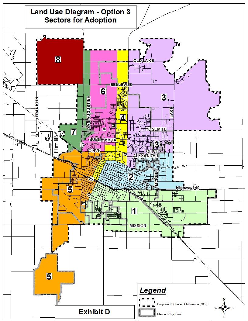
29 ADDITIONAL CHANGES TO GENERAL PLAN DRAFT BASED ON OPTION 3 (MODIFIED EIR ALTERNATIVE #2 REMOVAL OF MISSION LAKES ONLY) Executive Summary # Pg. Col Change Source 108 I-v -- R Figure entitled Specific Urban Development Plan and Sphere of Influence at top of right-hand column will be amended to reflect the adopted SUDP/SOI by City Council. 109 I-v 2 R 1 st sentence should read as follows: The Merced Vision 2030 General Plan proposes an expansion of the City s SUDP/SOI by approximately 10,400 12,900 acres to accommodate the City s projected growth over the next 20 years. 110 I-vii 2 R 2 nd sentence of paragraph under 4) Community Plans should read as follows: The City has six adopted Plans and six seven proposed plans. Chapter 2 Urban Expansion # Pg. Col Change Source L 4 th and 5 th sentences under #1 shall be deleted as follows: There is a proposal for a new Planned Community ( Mission Lakes ) south of the Airport. While the property is significantly impacted by airport land use policies, there may be sufficient land to accommodate some residential development, but specific land uses will need to be determined through the Community Plan process, which will follow the adoption of the General Plan L 2 nd and 3 rd sentences of the 1 st paragraph under Proposed SUDP/SOI 1 R Changes shall be amended as follows: The 1997 SUDP has been expanded to include some areas within the 1997 SOI (i.e., the Rural Residential Centers between Gardner and Lake, the UC Merced Campus, etc.), but also adding other areas outside the 1997 SOI (such as the University Community, and Castle Farms, and Mission Lakes) and deleting some areas that were inside the 1997 SOI (much of the Smith Trust lands north of the UC Merced Campus). However, the net change in absolute size is minimal (Figure 2.3) with the proposed SUDP/SOI being 31,076 33,463 acres while the SOI in 1997 was approximately 33,700 acres R Last sentence of the top paragraph continued from the previous column should be amended as follows: A corresponding increase is proposed for the northwest (Castle Farms) and southwest (Mission Lakes) for master planned communities. EXHIBIT B--Page 24 (Option 3)
30 Chapter 2 Urban Expansion (Cont.) # Pg. Col Change Source L 1 st sentence should be amended to read: An outline of the areas proposed for inclusion in the Draft SUDP/SOI, which is approximately 31,076 33,463 acres, can be found below R The first bullet should be deleted as follows: Area 8 (Mission Lakes) R Under the two columns entitled Short-Term Development and Long-Term Development, the following changes should be made (the rest will remain the same): Short-Term Development Area 8 (phased from north to south) Long-Term Development Area 8 (south portion) Figure 2.4.b City of Merced Area of Interest (AOI) shall be amended to show the AOI (including areas that might have been removed from the SUDP/SOI) as adopted by the City Council. Chapter 3 Land Use # Pg. Col Change Source Section Mission Lakes Community Plan will be deleted and other sections will be renumbered to accommodate that deletion L The 1 st and 2 nd sentences will be amended as follows: The Merced City Specific Urban Development Plan (SUDP)/ Sphere of Influence (SOI) area established by the Merced Vision 2030 General Plan encompasses approximately 31,000 33,500 acres (or square miles.) (Figure 3.2 illustrates the City s SUDP/SOI.) Figure 3.2 Proposed Sphere of Influence/Specific Urban Development Plan will be amended to reflect the boundary as adopted by the City Council Table 3.1 Merced Planned Land Use Summary will be amended as follows: The Column entitled 2030 GP SUDP/SOI Percent of Total will be updated to reflect the new numbers for each land use category based on the new SUDP/SOI size of 31,076. (Calculations to be done later.) Community Plan Areas under 2030 GP SUDP/SOI Acres will be changed from 8,115 to 5,615. Community Plan Areas under 2030 GP SUDP/SOI Percent of Total will be changed from to Total SUDP/SOI Area under 2030 GP SUDP/SOI Acres will be changed from 33,463 to 31,076. EXHIBIT B--Page 25 (Option 3)
31 Chapter 3 Land Use (Cont.) # Pg. Col Change Source L The last sentence under d shall be amended as follows: d) commercial sites within other Community Plans, such as Castle Farms and Mission Lakes Figure 3.5 Merced Regional Enterprise Zone will be amended to show the SUDP/SOI as adopted by the City Council Figure 3.6 Commercial and Industrial Corridors will be amended to show the SUDP/SOI as adopted by the City Council The 2 nd paragraph of the explanation under Implementing Action L- 3.6.a will be amended as follows: The Land Use Diagram proposes the establishment of six seven new Community Plan areas (Figure 3.9). These areas are as follows: 1) The University Community Plan (Section 3.7.3); 2) The Bellevue Corridor Community Plan (Section 3.7.4); 3) Castle Farms Community Plan (Section 3.7.5); 4) South Thornton (or Five Bridges ) Community Plan (Section 3.7.6); 5) Mission Lakes Community Plan (Section 3.7.7); 6) 5) South Mission Community Plan (Section ); 7) 6) Yosemite Lakes Community Plan (Section ) L The 3rd paragraph will be amended as follows: The Land Use Diagram proposes the establishment of six seven new Community Plan areas (Figure 3.9) as follows: 1) The University Community Plan (Section 3.7.3); 2) The Bellevue Corridor Community Plan (Section 3.7.4); 3) Castle Farms Community Plan (Section 3.7.5); 4) South Thornton (or Five Bridges ) Community Plan (Section 3.7.6); 5) Mission Lakes Community Plan (Section 3.7.7); 6) 5) South Mission Community Plan (Section ); 7) 6) Yosemite Lakes Community Plan (Section ) Figure 3.9 Proposed Community Plans shall be amended to remove to 3-76 the Mission Lakes Community Plan area Section Mission Lakes Community Plan in its entirety shall be deleted, and Section South Mission Community Plan and Section Yosemite Lakes Community Plan will be renumbered to Sections and respectively The Figure illustrating the conceptual Mission Lakes Community Plan shall be deleted. EXHIBIT B--Page 26 (Option 3)
32 Chapter 4 Transportation and Circulation # Pg. Col Change Source Figure 4.1 City of Merced Circulation Plan shall be amended to reflect the SUDP/SOI as adopted by City Council Figure 4.2 Major Regional Routes shall be amended to reflect the SUDP/SOI as adopted by City Council Figure 4.8 Railroads Through Merced shall be amended to reflect the SUDP/SOI as adopted by City Council. Chapter 5 Public Services and Facilities # Pg. Col Change Source Figure 5.1 Existing and Proposed Fire Station Locations shall be amended to reflect the SUDP/SOI as adopted by the City Council. Chapter 7 Open Space, Conservation & Recreation # Pg. Col Change Source Figure 7.1 Merced Parks and Open Space Master Plan shall be amended to reflect the SUDP/SOI as adopted by the City Council. Chapter 8 Sustainable Development # Pg. Col Change Source Figure 8.2 Planning Area Wetlands Inventory shall be amended to reflect the SUDP/SOI as adopted by the City Council Figure 8.4 Merced Area Soil Capability Groups shall be amended to reflect the SUDP/SOI as adopted by the City Council Figure 8.5 Merced Area Soil Association Map shall be amended to reflect the SUDP/SOI as adopted by the City Council Figure 8.6 Merced Area Important Farmland Map shall be amended to reflect the SUDP/SOI as adopted by the City Council. Chapter 11-- Safety # Pg. Col Change Source Figure 11.3 Dam Failure Inundation Areas shall be amended to reflect the SUDP/SOI as adopted by the City Council. EXHIBIT B--Page 27 (Option 3)
33 Chapter 11 Safety (Cont.) # Pg. Col Change Source Figure 11.5 Flood Prone Areas shall be amended to reflect the SUDP/SOI as adopted by the City Council Figure 11.6 Fire Station Service Areas shall be amended to reflect the SUDP/SOI as adopted by the City Council Figure 11.9 Merced Regional Airport & Castle Airport Land Use Compatibility Zones shall be amended to reflect the SUDP/SOI as adopted by the City Council Figure Police Districts shall be amended to reflect the SUDP/SOI as adopted by the City Council. Note: City staff reserves the right to correct any additional typographical errors found in the document after adoption as long as they don t change the substance of the text. If there are any conflicts between the additional changes required with Options 2 and 3 and the changes outlined in the earlier pages which correspond to Option 1, City staff will choose the change which best reflects final City Council action. EXHIBIT B--Page 28 (Option 3)

34 EXHIBIT 1 EXHIBIT B--Page 29 (Option 3)
35 Year EXHIBIT 2 (Note: This entire table is new and will be inserted after Table 2.1.a on page 2-7.) City of Merced Table 2.1.b City of Merced Population Projections ( ) UC Merced/ University Community Merced + UC Merced/Univ. Community County of Merced Percentage of County (Merced & UC) ,500 1,900 83, , % ,500 4,700 96, , % ,600 9, , , % ,800 15, , , % ,400 22, , , % ,100 31, , , % Source: Merced County Association of Governments, July 2010 EXHIBIT B--Page 30 (Option 3)
36 EXHIBIT 3 Table 3.1 Merced Planned Land Use Summary (2015 General Plan SUDP vs General Plan SUDP/SOI) 2015 GP SUDP 2030 GP SUDP/SOI Percent Percent Percent Land Use Classification Acres of Total Acres of Total Change RR (Rural Residential) ,301 2, AG (Agriculture) Total Agricultural Residential ,415 2, LD (Low-Density Residential) 8,497 7, ,771 8, LMD (Low-Medium Density) , ,177 1, Total Single-Family Residential 9,627 9, ,948 9, HMD (High-Medium Density) HD (High Density Residential) RMH (Residential Mobile Home) Total Multi-Family , P/G (Public/Government) CO (Commercial Office) Total Office 1,012 1, ,052 1, IND (Industrial) 2,877 2, ,877 2, IND-R (Industrial Reserve) , Total Industrial 3,027 2, ,100 3, BP (Business Park) BP-R (Business Park Reserve) Total Business Park , CG (General Commercial) CN (Neighborhood Commercial) CT (Thoroughfare Commercial) RC (Regional/Community) Total Commercial 1,769 1, ,966 1, OS-PK (Open Space/Park) ,107 1, Total Open Space ,107 1, Total School ,740 1, Total Other Lands* 1,404 2, ,244 2, Community Plan Areas ,115 7, N/A TOTAL SUDP/SOI AREA 20,598 33, ,711 33, Note: Open Space Inventory for the 2030 SUDP/SOI includes arterial street rights-of-way * Other Lands includes Village Residential, Residential Reserve, Commercial Reserve, Future School, "Future Park Source: Figure 3.1-Land Use Diagram as calculated by Quad Knopf, Inc., 2011 EXHIBIT B--Page 31 (Option 3)
37 EXHIBIT 4 Figure 4.27f Yosemite Avenue (East of Parsons/Gardner) Special Section EXHIBIT B--Page 32 (Option 3)
38 MERCED VISION 2030 GENERAL PLAN OPTION 3 Recommended Changes Since August 2010 Draft (Modified 9/23/11) Land Use Diagram # APN# Location Designation on Land Use Diagram (8/24/10) (UC 815 acres & Univ Comm North 833 acres) (40 acres) (58 acres) , -002, -003, - 8, -009, -010, -012, -013 (1.7 acres) (2.5 acres) (1 acre) (42 acres) Northeast and Southeast corners of Bellevue Rd & Lake Rd (UC Merced Campus & University Community) West of Highway 59, north of Santa Fe Drive Southwest corner of G and Farmland Northeast corner of Bancroft and Cardella Southeast corner of Hwy 59 & Buena Vista South of Yosemite, east of R Street Southwest corner of Gardner and Cardella School and Community Plan Business Park (BP) Low Density Residential (LD) Fire Station (PG) Business Park (BP) Low Density Residential (LD) Low Density Residential (LD)/Low Medium Density Residential (LMD) Corrected Designation Designations of School (SCH) and Community Plan (CP) remain but the boundaries change per Exhibit 1 Regional/ Community Commercial (RC) Source The UC Board of Regents adopted an EIR for the revised boundaries for the UC Merced Campus & University Community North on March 25, Property owner request to retain 1997 General Plan land use designation School (SCH) GPA # Res# Low Density Residential (LD) Neighborhood Commercial (CN) Business Park (BP) Commercial/ Professional Office (CO) & Low Medium Density Residential (LMD) GPA # Res # GPA # Res # GPA # Res # GPA # Res # EXHIBIT C Page 1 (Option 3)
39 # APN# Location Designation on Land Use Diagram (8/24/10) , & -008 (15,000 SF) , -005, -006 (11.5 acres) (14,000 SF) 11 Not Applicable , -006, & -007 (8.8 acres) , -021, -022, - 029, -035, - 036, -048, - 049, -052 thru -058, - 060, -062, & -063; , -004, -006, 008, -009, 012 thru -024 (Approx. 2,500 acres) Southwest corner of W 24 th and G Streets Northeast corner of Yosemite & G North of Donna/East of G Street (PD #26) Kibby Road (between Childs & Gerard Ave) Southwest corner of West Olive Ave & G Street Southwest corner of South Highway 59 & Mission Ave (Mission Lakes) High Medium Density Residential (HMD) High Medium Density Residential (HMD) Low Density Residential (LD) Collector Street shown from Childs to Gerard Neighborhood Commercial (CN) Community Plan (CP), within SUDP/SOI boundary Corrected Designation General Commercial (CG) Commercial/ Professional Office (CO) Commercial/ Professional Office (CO) Kibby Road has been vacated from Childs to Gerard Regional/ Community Commercial (RC) Area of Interest (AOI), outside of SUDP/SOI boundary Source GPA # Res # GPA # Res # GPA # Res # GPA #06-01/ Vacation # Res # / Res # GPA # Res # City Council Direction on EXHIBIT C Page 2 (Option 3)
40
Comprehensive Planning Grant. Comprehensive Plan Checklist
 Comprehensive Planning Grant Comprehensive Plan Checklist This form was updated April 2010 Comprehensive Planning Grant Program Department of Administration Division of Intergovernmental Relations 101
SOUTHWEST LRT (METRO GREEN LINE EXTENSION)
") 10 Joint Development This chapter describes potential long-term direct and indirect and short-term (construction) direct and indirect effects that would result from the Southwest Light Rail Transit (LRT)
10 Joint Development This chapter describes potential long-term direct and indirect and short-term (construction) direct and indirect effects that would result from the Southwest Light Rail Transit (LRT)
4 ESF 4 Firefighting
 4 ESF 4 Firefighting THIS PAGE LEFT BLANK INTENTIONALLY Table of Contents 1 Introduction... 1 1.1 Purpose and Scope... 1 1.2 Relationship to Other ESFs... 1 1.3 Policies and Agreements... 1 2 Situation
VILLAGE OF FOX CROSSING REQUEST FOR PROPOSAL FOR COMPREHENSIVE PLAN
 VILLAGE OF FOX CROSSING REQUEST FOR PROPOSAL FOR COMPREHENSIVE PLAN Issuing Department: Community Development Department Village of Fox Crossing 2000 Municipal Dr. Project Officer: George L. Dearborn Jr.,
CITY OF MERCED Planning & Permitting Division
 CITY OF MERCED Planning & Permitting Division STAFF REPORT: #11-09 AGENDA ITEM: 4.1 FROM: Kim Espinosa, PLANNING COMMISSION Planning Manager MEETING DATE: July 20, 2011 CITY COUNCIL (Tentative Date) MEETING
ANNEX R SEARCH & RESCUE
 ANNEX R SEARCH & RESCUE Hunt County, Texas Jurisdiction Ver. 2.0 APPROVAL & IMPLEMENTATION Annex R Search & Rescue NOTE: The signature(s) will be based upon local administrative practices. Typically, the
REQUEST FOR CITY COUNCIL ACTION
 REQUEST FOR CITY COUNCIL ACTION MEETING DATE: MARCH 14, 2017 TITLE: SCOPING SESSION FOR A GENERAL PLAN AMENDMENT REQUEST REPRESENTING AN EXCHANGE OF NON RESIDENTIAL BUILDING SQUARE FOOTAGE FOR NEW RESIDENTIAL
4.b. 6/22/2017. Local Agency Formation Commission. George J. Spiliotis, Executive Officer
 4.b. 6/22/2017 TO: FROM: SUBJECT: Local Agency Formation Commission George J. Spiliotis, Executive Officer LAFCO 2014-09-5 SPHERE OF INFLUENCE AMENDMENT TO THE CITY OF BEAUMONT (ADDITION) AND AMENDMENT
Order of Business. D. Approval of the Statement of Proceedings/Minutes for the meeting of January 24, 2018.
 COUNTY OF SAN DIEGO BOARD OF SUPERVISORS REGULAR MEETING MEETING AGENDA WEDNESDAY, FEBRUARY 14, 2018, 9:00 AM BOARD OF SUPERVISORS NORTH CHAMBER 1600 PACIFIC HIGHWAY, SAN DIEGO, CALIFORNIA Order of Business
Primary Agency. Support Agencies. I. Introduction. Pacific County Fire District # 1 (PCFD1)
") E S F 4 : F irefighting Primary Agency Pacific County Fire District # 1 (PCFD1) Support Agencies Pacific County Emergency Management Agency (PCEMA) Pacific County Fire Districts Municipal Fire Departments
E S F 4 : F irefighting Primary Agency Pacific County Fire District # 1 (PCFD1) Support Agencies Pacific County Emergency Management Agency (PCEMA) Pacific County Fire Districts Municipal Fire Departments
APPENDIX 1 BROWARD COUNTY PLANNING COUNCIL PLAN AMENDMENT REQUIREMENTS AND PROCEDURES
 APPENDIX 1 BROWARD COUNTY PLANNING COUNCIL PLAN AMENDMENT REQUIREMENTS AND PROCEDURES Broward County Land Use Plan Amendment Requirements Amendments which are not within the rules of flexibility or more
CONNECTED CITY FREQUENTLY ASKED QUESTIONS
 1) What is the Connected City project? CONNECTED CITY FREQUENTLY ASKED QUESTIONS The Connected City Corridor is a State-initiated pilot program that is unique to Pasco County, and will be the first planned
ESF 14 - Long-Term Community Recovery
 ESF 4 - Long-Term Community Recovery Coordinating Agency: Harvey County Emergency Management Primary Agency: Harvey County Board of County Commissioners Support Agencies: American Red Cross Federal Emergency
NC General Statutes - Chapter 136 Article 19 1
 Article 19. Congestion Relief and Intermodal 21 st Century Transportation Fund. 136-250. Congestion Relief and Intermodal Transportation 21 st Century Fund. There is established in the State treasury the
PINELLAS COUNTY DEO#12-1ESR
 Agenda Item #3.H.11 02/13/12 LOCAL GOVERNMENT COMPREHENSIVE PLAN PROPOSED AMENDMENT REPORT PINELLAS COUNTY DEO#12-1ESR 1 THIS PAGE INTENTIONALLY LEFT BLANK 2 PINELLAS COUNTY LPA 22-10-11 Expedited State
NOW THEREFORE, the parties enter into the following Agreement:
 Interlocal Agreement Between the Board of County Commissioners of St. Johns County, Florida, City of St. Augustine, City of St. Augustine Beach, Town of Hastings and the School Board of St. Johns County,
Beth Day Director, FTA Office of Project Planning RailVolution October 2011
 Beth Day Director, FTA Office of Project Planning RailVolution October 2011 What is a New or Small Start? New fixed guideways and extensions to existing systems Includes light rail, heavy rail, commuter
Comprehensive Plan 2009
 Comprehensive Plan 2009 2.14 PUBLIC SCHOOLS FACILITIES Goal: Coordinate and maintain a high quality education system. Collaborate and coordinate with the Okaloosa County School Board (School Board) to
UNIVERSITY OF CALIFORNIA, SANTA CRUZ
 UNIVERSITY OF CALIFORNIA, SANTA CRUZ BERKELEY DAVIS IRVINE LOS ANGELES MERCED RIVERSIDE SAN DIEGO SAN FRANCISCO SANTA BARBARA SANTA CRUZ PHYSICAL PLANNING, DEVELOPMENT & OPERATIONS UC SANTA CRUZ, CALIFORNIA
Transportation Alternatives Program Application For projects in the Tulsa Urbanized Area
 FFY 2015-2016 Transportation Alternatives Program Application For projects in the Tulsa Urbanized Area A Grant Program of Moving Ahead for Progress in the 21st Century (MAP-21) U.S. Department of Transportation
Yolo Operational Area Oil & Hazardous Materials Response Executive Summary
 This document outlines the planning and organizational responsibilities of the Oil and Hazardous Materials (ESF #10) coordinating agencies for the Yolo Operational Area Yolo Operational Area Oil & Hazardous
Department of Code Compliance
 Department of Code Compliance Code Compliance Operations AND 100-Day Plan Update Presented to the Quality of Life and Government Services Committee November 26, 2007 Purpose Overview/Background Typical
Planning Commission Public Hearing Exhibits. Powers Ready Mix Plant Oldcastle SW Group, Inc.
 Planning Commission Public Hearing Exhibits Powers Ready Mix Plant Oldcastle SW Group, Inc. Substantial Amendment to a Land Use Change Permit, Major Impact Review (File MPAA-02-16-8424) Applicant is CRC,
Senate Bill 379 Land use: general plan: safety element: climate adaptation Senator Hannah-Beth Jackson
 Senate Bill 379 Land use: general plan: safety element: climate adaptation Senator Hannah-Beth Jackson SUMMARY Under current law, every city and county must adopt a general plan with seven mandatory elements:
Mission Bay Master Plan File No M September 27, 1990
 SAN FRANCISCO CITY PLANNING COMMISSION RESOLUTION NO. 12040 WHEREAS, Mission Bay is generally bounded by Third Street, Berry Street, Fourth Street, the China Basin Channel, China Basin Street, Mariposa
MEMORANDUM AGENDA ITEM #6k
 South Florida Regional Planning Council MEMORANDUM AGENDA ITEM #6k DATE: SEPTEMBER 8, 2008 TO: FROM: SUBJECT: COUNCIL MEMBERS STAFF TOWN OF MEDLEY PROPOSED COMPREHENSIVE PLAN AMENDMENT Introduction On
Your Development Project and the Public Works Department Part
 Other useful publications available to help you through the development process: Title 8, Planning and Zoning, County Ordinance Code Title 9, Subdivisions, County Ordinance Code Your Development Project
Read the scenario below, and refer to it to answer questions 1 through 13.
 Instructions: This test will help you to determine topics in the course with which you are familiar and those that you must pay careful attention to as you complete this Independent Study. When you have
Emergency Support Function (ESF) 16 Law Enforcement
 16 Law Enforcement") Emergency Support Function (ESF) 16 Law Enforcement Primary Agency: Support Agencies: Escambia County Sheriff's Office City of Pensacola Police Department Escambia County Clerk of Circuit Court Administration
Emergency Support Function (ESF) 16 Law Enforcement Primary Agency: Support Agencies: Escambia County Sheriff's Office City of Pensacola Police Department Escambia County Clerk of Circuit Court Administration
EMERGENCY SUPPORT FUNCTION 1 TRANSPORTATION
 59 Iberville Parish Office of Homeland Security And Emergency Preparedness EMERGENCY SUPPORT FUNCTION 1 TRANSPORTATION I. PURPOSE: ESF 1 provides for the acquisition, provision and coordination of transportation
TILLAMOOK COUNTY, OREGON EMERGENCY OPERATIONS PLAN ANNEX R EARTHQUAKE & TSUNAMI
 TILLAMOOK COUNTY, OREGON EMERGENCY OPERATIONS PLAN ANNEX R EARTHQUAKE & TSUNAMI I. PURPOSE A. Tillamook coastal communities are at risk to both earthquakes and tsunamis. Tsunamis are sea waves produced
COMMUNITY MEETING NOTES UCSF Mission Bay Phase 2 Study. Meeting Date: June 17, 2010 Genentech Hall Mission Bay campus Subject: Community Meeting 1
 COMMUNITY MEETING NOTES UCSF Mission Bay Phase 2 Study Meeting Date: June 17, 2010 Location: Genentech Hall Mission Bay campus Subject: Community Meeting 1 Attendees: Neighbors UCSF staff San Francisco
Florida Job Growth Grant Fund Public Infrastructure Grant Proposal
 Florida Job Growth Grant Fund Public Infrastructure Grant Proposal Proposal Instructions: The Florida Job Growth Grant Fund Proposal (this document) must be completed by the governmental entity applying
FIRE DEPARTMENT. Administration. Fire Prevention. Disaster Preparedness. Suppression. Hazardous Materials. Ambulance
 FIRE DEPARTMENT Administration Disaster Preparedness Hazardous Materials Fire Prevention Suppression Ambulance OP-85 FIRE DEPARTMENT The Petaluma Fire Department is a full service Fire Protection and Emergency
Public Safety and Security
 Public Safety and Security ESF #13 GRAYSON COLLEGE EMERGENCY MANAGEMENT Table of Contents Table of contents..1 Approval and Implementation.3 Recorded of Change.4 Emergency Support Function 13- Public Safety..5
On February 28, 2003, President Bush issued Homeland Security Presidential Directive 5 (HSPD 5). HSPD 5 directed the Secretary of Homeland Security
. HSPD 5 directed the Secretary of Homeland Security") On February 28, 2003, President Bush issued Homeland Security Presidential Directive 5 (HSPD 5). HSPD 5 directed the Secretary of Homeland Security to develop and administer a National Incident Management
On February 28, 2003, President Bush issued Homeland Security Presidential Directive 5 (HSPD 5). HSPD 5 directed the Secretary of Homeland Security to develop and administer a National Incident Management
UCSF Long Range Development Plan (LRDP)
") UCSF Long Range Development Plan (LRDP) Further information: Lori Yamauchi Assistant Vice Chancellor Campus Planning Commission on Community Investment and Infrastructure August 20, 2013 UCSF Overview
UCSF Long Range Development Plan (LRDP) Further information: Lori Yamauchi Assistant Vice Chancellor Campus Planning Commission on Community Investment and Infrastructure August 20, 2013 UCSF Overview
2570. Short Title. This subchapter shall be known and may be cited as the Disaster Service Worker Volunteer Program (DSWVP) Regulations.
 Regulations.") TITLE 19. PUBLIC SAFETY DIVISION 2. OFFICE OF EMERGENCY SERVICES CHAPTER 2. EMERGENCIES AND MAJOR DISASTERS SUBCHAPTER 3. DISASTER SERVICE WORKER VOLUNTEER PROGRAM 2570. Short Title. This subchapter shall
TITLE 19. PUBLIC SAFETY DIVISION 2. OFFICE OF EMERGENCY SERVICES CHAPTER 2. EMERGENCIES AND MAJOR DISASTERS SUBCHAPTER 3. DISASTER SERVICE WORKER VOLUNTEER PROGRAM 2570. Short Title. This subchapter shall
City of Folsom FY Final Budget
 Mission Statement Budget Summary Program Information Accomplishments Work Plan Key Issues Position Information Major Contracts New and Replacement Vehicles IV-69 Mission Statement The Folsom City Department
REPORT. To the Honorable Mayor and City Council From the City Manager. May 9, 2016
 REPORT To the Honorable Mayor and City Council From the City Manager May 9, 2016 SUBJECT Study Session for Consideration of the Draft Inner Harbor Specific Plan, Draft Inner Harbor Specific Plan Environmental
MANDAN FIRE DEPARTMENT STANDARD OPERATION PROCEDURES
 GENERAL ORDER # 105.03 DATE: September 18, 1998 Incident Command System 1 of 22 OBJECTIVE: To establish a procedure that will provide for a uniform Incident Management System. SCOPE: The Incident Command
November 13, Planning and Land Development Regulation Commission (PLDRC) 1725 N. U.S. Highway 1, Ormond Beach. John H. Stockham, Planner III
 1725 N. U.S. Highway 1, Ormond Beach. John H. Stockham, Planner III") 1 of 19 GROWTH AND RESOURCE MANAGEMENT DEPARTMENT PLANNING AND DEVELOPMENT SERVICES DIVISION CURRENT PLANNING ACTIVITY 123 W. Indiana Avenue, DeLand, FL 32720 (386) 943-7059 PUBLIC HEARING: CASE NO: SUBJECT:
1 of 19 GROWTH AND RESOURCE MANAGEMENT DEPARTMENT PLANNING AND DEVELOPMENT SERVICES DIVISION CURRENT PLANNING ACTIVITY 123 W. Indiana Avenue, DeLand, FL 32720 (386) 943-7059 PUBLIC HEARING: CASE NO: SUBJECT:
CITY OF LA CENTER PUBLIC WORKS
 CITY OF LA CENTER PUBLIC WORKS TRAFFIC CALMING PROGRAM APPROVED PER RESOLUTION 08-304 ON DECEMBER 10, 2008 TABLE OF CONTENTS PAGE Summary... 1 Procedures... 2 Project Eligibility... 2 Project Funding &
Administrative Procedure
 Administrative Procedure Number: 408 Effective: Interim Supersedes: 07/28/1998 Page: 1 of 7 Subject: EMERGENCY ACTION PLAN 1.0. PURPOSE: To establish procedures for the evacuation of University buildings
INTERGOVERNMENTAL COORDINATION ELEMENT
 INTERGOVERNMENTAL COORDINATION ELEMENT I. PURPOSE The purpose of this Element is to identify and resolve incompatible goals, objectives, policies and development proposed by other governmental entities,
Transit-Oriented Development and Land Use Subarea Plan for Central Lake Forest Park
 CITY OF LAKE FOREST PARK REQUEST FOR PROPOSALS Transit-Oriented Development and Land Use Subarea Plan for Central Lake Forest Park PROJECT DESCRIPTION The City of Lake Forest Park is seeking qualified
THE STATE OF FLORIDA WILDFIRE OPERATIONS ANNEX
 FLORIDA COMPREHENSIVE EMERGENCY MANAGEMENT PLAN 2014 THE STATE OF FLORIDA WILDFIRE OPERATIONS ANNEX To The State of Florida Comprehensive Emergency Management Plan FLORIDA COMPREHENSIVE EMERGENCY MANAGEMENT
Transportation Alternatives (TA) Northeast Minnesota Workshop
 Northeast Minnesota Workshop") Transportation Alternatives (TA) Northeast Minnesota Workshop October 4 th, 2016 1 What are TA Projects? Federally funded community based projects o Expand travel choices o Integrate modes o Improve cultural,
Transportation Alternatives (TA) Northeast Minnesota Workshop October 4 th, 2016 1 What are TA Projects? Federally funded community based projects o Expand travel choices o Integrate modes o Improve cultural,
ADAMS COUNTY COMPREHENSIVE EMERGENCY MANAGEMENT PLAN HAZARDOUS MATERIALS
 ADAMS COUNTY COMPREHENSIVE EMERGENCY MANAGEMENT PLAN EMERGENCY SUPPORT FUNCTION 10A HAZARDOUS MATERIALS Primary Agencies: Support Agencies: Adams County Emergency Management Fire Departments and Districts
WESTERN SLOPE CIP AND TIM FEE UPDATE
 WESTERN SLOPE CIP AND TIM FEE UPDATE 12/6/16 BOARD OF SUPERVISORS STUDY SESSION B O A R D S T U D Y S E S S I O N # 8 2015 14-0245 Revised 22M 1 of 53 AGENDA 1. Background 2. Programmatic EIR 3. General
HELIBASE DEVELOPMENT PROJECT
 HELIBASE DEVELOPMENT PROJECT Scoping Report February, 2016 Project Number: 48670 Mark Twain National Forest Service Houston/Rolla/Cedar Creek Ranger District Phelps County, Missouri In accordance with
APPENDIX METROFUTURE OVERVIEW OVERVIEW
 APPENDIX B METROFUTURE OVERVIEW OVERVIEW Land use decisions and many economic development decisions in Massachusetts are controlled directly by local municipalities through zoning. This planning is guided
ESF 4 - Firefighting
 ESF Annexes ESF 4 - Firefighting Coordinating Agency: Cowley County Fire Chiefs Association Primary Agency: Arkansas City Fire/EMS Department (Fire District #5) Atlanta Fire Dept. (Fire District #) Burden
ESF 13 - Public Safety and Security
 ESF Annexes Coordinating Agency: Cowley County Sheriff's Department Primary Agency: Arkansas City Police Department Burden Police Department Dexter Police Department Udall Police Department Winfield Police
ADMINISTRATIVE CODE BOARD OF COUNTY COMMISSIONERS
 ADMINISTRATIVE CODE BOARD OF COUNTY COMMISSIONERS CATEGORY: DEVELOPMENT/PLANNING/ZONING TITLE: TRANSPORTATION PROPORTIONATE SHARE CALCULATIONS FOR NEW DEVELOPMENT PROJECTS CODE NUMBER: AC-13-16 ADOPTED:
ANNEX F. Firefighting. City of Jonestown. F-i. Ver 2.0 Rev 6/13 MP
 ANNEX F Firefighting City of Jonestown F-i RECORD OF CHANGES CHANGE # DATE OF CHANGE DESCRIPTION CHANGED BY F-ii APPROVAL & IMPLEMENTATION Annex F Firefighting Fire Chief Date EMC Date. F-iii ANNEX F FIREFIGHTING
Nassau County 2030 Comprehensive Plan. Public School Facilities Element (PSF) Goals, Objectives and Policies. Goal
 Goals, Objectives and Policies. Goal") (PSF) Goal Work closely with the School District of Nassau County to ensure a high quality, fiscally sound public school system which meet the needs of Nassau County s population by providing and maintaining
(PSF) Goal Work closely with the School District of Nassau County to ensure a high quality, fiscally sound public school system which meet the needs of Nassau County s population by providing and maintaining
THIS PAGE LEFT BLANK INTENTIONALLY
 ESF 4 Firefighting THIS PAGE LEFT BLANK INTENTIONALLY Table of Contents 1 Introduction... ESF 4-1 1.1 Purpose... ESF 4-1 1.2 Scope... ESF 4-1 2 Situation and Assumptions... ESF 4-1 2.1 Situation... ESF
Building our future, together. Steering Committee Presentation for the Comprehensive Plan Update November 12, 2013
 Building our future, together Steering Committee Presentation for the Comprehensive Plan Update November 12, 2013 Introduction Welcome: Mayor Barbara Bass Prayer Business and Economy Update Susan Guthrie,
MEMORANDUM. AGENDA ITEM #3D December 5, December 1, TO: County Council FROM:
 AGENDA ITEM #3D December 5, 2017 MEMORANDUM December 1, 201 7 TO: FROM: County Council Marlene Michaels~~1ior Legislative Analyst Glenn Orlin, Deputy Council Administrator &O SUBJECT: Grosvenor-Strathmore
4. IMPLEMENTATION. 4.1 Implementation Matrix
 4. IMPLEMENTATION 4.1 Implementation Matrix IMPLEMENTATION MATRIX The Implementation Matrix includes the implementation items, proposed time line, potential participating parties and potential funding
ANNEX 4 ESF-4 - FIREFIGHTING. SC Department of Labor, Licensing, and Regulation, Division of Fire and Life Safety (Structural Fires)
") ANNEX 4 ESF-4 - FIREFIGHTING PRIMARY: SC Department of Labor, Licensing, and Regulation, Division of Fire and Life Safety (Structural Fires) SC Forestry Commission (Wildland Fires) SUPPORT: SC Department
ANNEX 4 ESF-4 - FIREFIGHTING PRIMARY: SC Department of Labor, Licensing, and Regulation, Division of Fire and Life Safety (Structural Fires) SC Forestry Commission (Wildland Fires) SUPPORT: SC Department
Mississippi Emergency Support Function #10 Oil and Hazardous Materials
 Emergency Support Function #10 Oil and Hazardous Materials ESF #10 Coordinator Department of Environmental Quality Primary Agencies Department of Environmental Quality State Department of Health/Division
BRANDON UNIVERSITY DOWNTOWN PROJECT REQUEST FOR EXPRESSION OF INTEREST (REOI)
") BRANDON UNIVERSITY DOWNTOWN PROJECT REQUEST FOR EXPRESSION OF INTEREST (REOI) 1. Project Description Brandon University seeks expressions of interest from private parties who will partner with the University
BRANDON UNIVERSITY DOWNTOWN PROJECT REQUEST FOR EXPRESSION OF INTEREST (REOI) 1. Project Description Brandon University seeks expressions of interest from private parties who will partner with the University
Kanawha Putnam Emergency Management Plan Functional Annex. (completed by plan authors) Local / County Office of Emergency Management
 Local / County Office of Emergency Management") Kanawha Putnam Emergency Management Plan Functional Annex Chemical HazMat Response A16 Coordination: Primary Agency: (completed by plan authors) Local / County Office of Emergency Management Support Agencies:
Kanawha Putnam Emergency Management Plan Functional Annex Chemical HazMat Response A16 Coordination: Primary Agency: (completed by plan authors) Local / County Office of Emergency Management Support Agencies:
TRANSPORTATION FUNDING PROGRAMS
 APPENDIX A Note: Not yet edited by DCPD. TRANSPORTATION FUNDING PROGRAMS 6 Transportation Funding Programs The following provides a brief description of transportation related funding programs that are
Coolidge - Florence Regional Transportation Plan
 Coolidge - Florence Regional Transportation Plan A Partnership Among the City of Coolidge, Town of Florence, and ADOT FINAL REPORT Kimley-Horn Kimley Kimley-Horn and and Associates, Associates, Inc. Inc.
Managing CDBG. A Guidebook for Grantees on Subrecipient Oversight. U.S. Department of Housing and Urban Development
 U.S. Department of Housing and Urban Development Office of Community Planning and Development Community Development Block Grant Program Managing CDBG A Guidebook for Grantees on Subrecipient Oversight
ANNEX 4 ESF-4 - FIREFIGHTING. South Carolina Department of Labor, Licensing, and Regulation, Division of Fire and Life Safety (Structural Fires)
") ANNEX 4 ESF-4 - FIREFIGHTING COORDINATING: PRIMARY: SUPPORTING: South Carolina Department of Labor, Licensing, and Regulation, Division of Fire and Life Safety (Structural Fires) South Carolina Forestry
ANNEX 4 ESF-4 - FIREFIGHTING COORDINATING: PRIMARY: SUPPORTING: South Carolina Department of Labor, Licensing, and Regulation, Division of Fire and Life Safety (Structural Fires) South Carolina Forestry
MEMORANDUM. Governor John Hickenlooper & Members of the Colorado General Assembly
 690 Kipling Street, Suite 3000 Lakewood, CO 80215 MEMORANDUM TO: FROM: Governor John Hickenlooper & Members of the Colorado General Assembly Paul L. Cooke, Director DATE: April 28, 2015 RE: 2015 Wildfire
Multiple Patient Management Plan
 2018 [NAME OF PLAN] Multiple Patient Management Plan Marin County Health & Human Services Emergency Medical Services Agency Supports the Marin County Operational Area Emergency Operations Plan and Medical
NORTH CENTRAL TEXAS COUNCIL OF GOVERNMENTS METROPOLITAN PLANNING ORGANIZATION REQUEST FOR PROPOSALS
 NORTH CENTRAL TEXAS COUNCIL OF GOVERNMENTS METROPOLITAN PLANNING ORGANIZATION REQUEST FOR PROPOSALS CITY OF CEDAR HILL CITY CENTER TRANSIT-ORIENTED DEVELOPMENT PLAN August 19, 2011 REQUEST FOR PROPOSALS
Pensacola Fire Department. FY 2016 Budget Workshop
 Pensacola Fire Department FY 2016 Budget Workshop 1 Mission The primary mission of the Pensacola Fire Department is to provide a wide range of services and programs designed to protect lives and property
METHODOLOGY - Scope of Work
 The scope of work for the Truckee West River Site Redevelopment Feasibility Study will be undertaken through a series of sequential steps or tasks and will comprise four major tasks as follows. TASK 1:
ANNEX Q HAZARDOUS MATERIALS EMERGENCY RESPONSE
 ANNEX Q HAZARDOUS MATERIALS EMERGENCY RESPONSE PROMULGATION STATEMENT Annex Q: Hazardous Materials Emergency Response, and contents within, is a guide to how the University conducts a response specific
APPENDIX A PROGRAMMATIC AGREEMENT FOR MINOR TRANSPORTATION PROJECTS
 APPENDIX A PROGRAMMATIC AGREEMENT FOR MINOR TRANSPORTATION PROJECTS PROGRAMMATIC AGREEMENT AMONG THE FEDERAL HIGHWAY ADMINISTRATION THE PENNSYLVANIA DEPARTMENT OF TRANSPORTATION, THE PENNSYLVANIA STATE
EMERGENCY SUPPORT FUNCTION 1 TRANSPORTATION
 EMERGENCY SUPPORT FUNCTION 1 TRANSPORTATION Primary Agency County Fleet Operations Support Agencies Board of Education Area Transit County Engineering Dept. Emergency Management Agency Mosquito Control
Greater Cambridge Partnership Executive Board. Chris Tunstall Interim Transport Director. Western Orbital
 Report To: Lead Officer: Greater Cambridge Partnership Executive Board Chris Tunstall Interim Transport Director 20 September 2017 Purpose Western Orbital 1. This report updates the Greater Cambridge Partnership
2018 Regional Project Evaluation Criteria For PSRC s FHWA Funds
 2018 Regional Project Evaluation Criteria For PSRC s FHWA Funds INTRODUCTION As described in the adopted 2018 Policy Framework for PSRC s Federal Funds, the policy focus for the 2018 project selection
CITY COUNCIL File #
 19 82 STAFF REPORT CITY CLERK O`LIFOU CITY COUNCIL File # 420-30 DATE: June 2, 2015 TO: Honorable Mayor and City Councilmembers FROM: Christopher L. Foss, City Manager J SUBJECT: Amendments to the General
Mike Chard Paul Eller
 Why Should I have or be involved in an Emergency Management Program? Bruce Holloman Mike Chard Paul Eller www.dhsem.state.co.us Why As Political Subdivisions of Government and elected officials you have
NIMS and the Incident Command System (ICS)
") Introduction The way this nation prepares for and responds to domestic incidents is about to change. It won't be an abrupt change; best practices that have been developed over the years are part of this
Introduction The way this nation prepares for and responds to domestic incidents is about to change. It won't be an abrupt change; best practices that have been developed over the years are part of this
Economic Development. Implement three programs from the Economic Development Plan. friendly, efficient and timely delivery of services
 2017-19 STRATEGIC PLAN Value Statement Treat all persons, claims and transaction in a fair and equitable manner. Make responsible decisions by taking the long-range consequences into consideration. Base
Chapter 9: Economic Development
 Chapter 9: Economic Development 9.0 Accomplishments Since 2007 As the economic driver for the State, New Castle County continues to review development regulations and offer additional incentives and enhancements
2 Addendum - Response and Recovery Matrix
 2 Addendum - Response and Recovery Matrix This page left blank intentionally Response Matrix (P=Primary, S = Secondary) Individual County Departments Outside Agencies Local Plan Annex FUNCTION Administration
AUSTIN/MOWER COUNTY-WIDE
 PART A - RADIOLOGICAL PROTECTION The purpose of this standard operating guideline is to outline the actions and responsibilities of personnel designated to protect the citizens of Mower County from the
IRVINE UNIFIED SCHOOL DISTRICT RESPONSE TO COMMENTS FOR THE PLANNING AREA 6 NORTH ELEMENTARY SCHOOL
 IRVINE UNIFIED SCHOOL DISTRICT RESPONSE TO COMMENTS FOR THE PLANNING AREA 6 NORTH ELEMENTARY SCHOOL Prepared for: IRVINE UNIFIED SCHOOL DISTRICT Facilities Planning & Construction Services Departments
Downtown Shoulder Area Community Improvement Plan. Investing in our Community
 Downtown Shoulder Area Community Improvement Plan Investing in our Community The Downtown Shoulder Area Renaissance Community Improvement Plan consists of the following: PART A - The preamble which does
Mississippi Emergency Support Function #4 Firefighting Annex
 ESF #4 Coordinator Mississippi Fire Marshal s Office Primary Agency Mississippi Insurance Department Federal ESF Coordinator Department of Agriculture/U.S. Forest Federal Primary Agency Department of Agriculture/U.S.
Guidelines for Developers and Local Governments
 Nature-based Parks Guidelines for Developers and Local Governments This Guideline is to assist developers and operators with the preparation of a Management Plan that will underpin the licensing and regulation
City and County of San Francisco Emergency Support Function #5 Emergency Management Annex
 Contents FOREWORD Process Flowchart Anticipated Event... iii Process Flowchart Unanticipated Event... v SECTION 1: INTRODUCTION...1 1.1 Coordinating and Supporting Departments... 1 1.2 ESF Responsibilities...
CHAPTER House Bill No. 5013
 CHAPTER 2009-89 House Bill No. 5013 An act relating to transportation; amending s. 334.044, F.S.; revising the powers and duties of the Department of Transportation to provide for certain environmental
TITLE 7 FIRE PROTECTION AND FIREWORKS 1 CHAPTER 1 MISCELLANEOUS
 7-1 TITLE 7 FIRE PROTECTION AND FIREWORKS 1 CHAPTER 1. MISCELLANEOUS. 2. VOLUNTEER FIRE DEPARTMENT. 3. FIREWORKS. CHAPTER 1 MISCELLANEOUS SECTION 7-101. Fire department prohibited from connecting to restrictive
Emergency Support Function (ESF) #15: LAW ENFORCEMENT & SECURITY. ESF Activation Contact: Cornell Police Dispatch Center (607)
 #15: LAW ENFORCEMENT & SECURITY. ESF Activation Contact: Cornell Police Dispatch Center (607)") Emergency Support Function (ESF) #15: LAW ENFORCEMENT & SECURITY ESF Activation Contact: Cornell Police Dispatch Center (607)255-1111 Primary Department I. Purpose Cornell University Police PH: (607)255-1111
Emergency Support Function (ESF) #15: LAW ENFORCEMENT & SECURITY ESF Activation Contact: Cornell Police Dispatch Center (607)255-1111 Primary Department I. Purpose Cornell University Police PH: (607)255-1111
TRAFFIC IMPACT ANALYSIS IMPLEMENTATION. Richard L. Caywood, P.E. Robert W. Hofrichter
 TRAFFIC IMPACT ANALYSIS IMPLEMENTATION Richard L. Caywood, P.E. Robert W. Hofrichter Chapter 527: What is it? Passed by General Assembly in 2006 adding Section 15.2-2222.1 to Code of Virginia Directs localities
CITY OF COLUMBIA. Columbia Police Department. Proposed Police Emergency Vehicle Operation and Motor Vehicle Pursuit Policy
 CITY OF COLUMBIA Columbia Police Department February 28, 2013 To: Teresa Wilson, City Manager From: Randy Scott, Chief of Police Re: Proposed Policy The enclosed proposed Policy is submitted to update
Marin County EMS Agency
 Marin County EMS Agency Multiple Patient Management Plan Excellent Care Every Patient, Every Time July 2013 899 Northgate Drive #104, San Rafael, CA 94903 ph. 415-473-6871 fax 415-473-3747 www.marinems.org
INTRODUCTION. RTPO Model Program Guide February 27, 2007 Page 1
 TABLE OF CONTENTS INTRODUCTION... 1 HOW TO USE THIS GUIDE... 2 SECTION I: LAND USE AND TRANSPORTATION CONTEXT... 3 SECTION II: MINIMUM CRITERIA FOR GROWTH AND TRANSPORTATION EFFICIENCY CENTERS... 5 SECTION
EMERGENCY MANAGEMENT PLANNING CRITERIA FOR HOSPITALS
 EMERGENCY MANAGEMENT PLANNING CRITERIA FOR HOSPITALS The following minimum criteria are to be used when developing Comprehensive Emergency Management Plans (CEMP) for all hospitals. These criteria will
Chairman and Members of the Planning and Development Committee. Thomas S. Mokrzycki, Commissioner of Planning and Building
 CD.03.CIT City Plan DATE: TO: FROM: SUBJECT: Chairman and Members of the Planning and Development Committee Thomas S. Mokrzycki, Commissioner of Planning and Building Proposed City Plan, Draft Mississauga