DEPARTMENT OF THE NAVY HEADQUARTERS UNITED STATES MARINE CORPS 3000 MARINE CORPS PENTAGON WASHINGTON, DC
|
|
|
- Noreen Marilyn Haynes
- 5 years ago
- Views:
Transcription


1
2 DEPARTMENT OF THE NAVY HEADQUARTERS UNITED STATES MARINE CORPS 3000 MARINE CORPS PENTAGON WASHINGTON, DC NREPLYREF RTO LF From: Commandant of the Marine Corps (LF) To: Commanding General, Marine Corps Installations East, PSC Box 20005, Marine Corps Base, Camp Lejeune, NC Subj: MARINE CORPS AIR STATION NEW RIVER, AIR INSTALLAIONS COMPATIBLE USE ZONES (AICUZ) STUDY UPDATE Ref: (a) AICUZ Update, MCAS New River, June The Air Installation Compatible Use Zones (AICUZ) Study for Marine Corps Air Station New River, as presented by the reference, is approved for implementation. 2. This study is a result of extensive analysis of all known methods to ensure that development of surrounding lands will be compatible with the potential noise and safety hazards associated with military activities at MCAF Quantico. 3. It is envisioned that through wide public distribution of this document and a continuing dialogue between the Commander, MCAS New River and local government officials, these land use recommendations can be adopted. 4. My point of contact for this matter is Major Andrew Marcelis, Copy to: MCI-East MCAS New River A. M. Edmonds By direction

3 Air Installations Compatible Use Zones Study for Marine Corps Air Station New River, North Carolina June 2011 Prepared by: UNITED STATES DEPARTMENT OF THE NAVY Naval Facilities Engineering Command, Atlantic Norfolk, Virginia
4 This page intentionally left blank.
5 Table of Contents Section Page List of Tables...v List of Figures...vi Acronyms and Abbreviations...vii 1 Introduction AICUZ Program Purpose, Scope, and Authority Responsibility for Compatible Land Use Previous AICUZ and Noise Studies Need for an AICUZ Update Changes in Operations Level Changes in Aircraft Mix Changes in Flight Tracks and Procedures MCAS New River Location Mission History McCutcheon Field Local Economic Impacts Aircraft Operations Aircraft Types Rotary-wing Aircraft Tilt-rotor Aircraft Fixed-wing Aircraft Squadron Organization Operational Areas Airspace Low Work Areas Aircraft Operations Flight Operations Annual Aircraft Operations Runway and Flight Track Utilization Low Work and Maintenance Run-Up Operations Aircraft Noise What is Sound/Noise? Airfield Noise Sources Noise Complaints Noise Abatement Procedures at MCAS New River Noise Exposure Contours AICUZ Noise Exposure Contours iii
6 Table of Contents, continued Section Page Comparison of 2001 AICUZ and 2011 AICUZ Noise Exposure Contours Airfield Safety Accident Potential Zones Aircraft Mishaps Aircraft APZs AICUZ APZs Comparison of 2001 AICUZ and 2011 AICUZ APZs Flight Safety Imaginary Surfaces Bird Aircraft Strike Hazard (BASH) Electromagnetic Interference Lighting Smoke, Dust, and Steam Land Use Compatibility Analysis Planning Authority Existing Zoning and Land Use Zoning Existing Land Use Future Land Use and Proposed Development AICUZ Composite Map Land-Use Compatibility Guidelines and Classifications Compatibility Concerns at MCAS New River AICUZ Recommendations and Strategies AICUZ Recommendations and Implementation MCAS New River Local and State Governments Private Citizens/Real Estate Professionals/Lending Institutions/Developers Federal Tools and Programs to Prevent Encroachment References Appendix A Land-Use Compatibility Recommendations... A-1 Appendix B Discussion of Noise and Its Effect on the Environment... B-1 iv
7 List of Tables Table Page 1-1 Responsibility for Compatible Land Uses Comparison of Annual Operations at MCAS New River Aircraft Mix, MCAS New River McCutcheon Field Runways FY 2010 MCAS New River Economic Impact Projected Annual Flight Operations at MCAS New River Runway Utilization, MCAS New River Projected Low Work Operations at MCAS New River Subjective Response to Noise Comparison of Land Area within Noise Zones, MCAS New River Land Area within 2011 AICUZ APZs, MCAS New River Imaginary Surfaces Class A Fixed-wing Runways Military Support Policies Onslow County and the City of Jacksonville Proposed Residential Subdivisions Land Use Classifications and Compatibility Guidelines v
8 List of Figures Figure Page 2-1 Regional Location Map McCutcheon Field Airfield Map Airspace Low Work Areas Aircraft Mix, MCAS New River (2009) Arrival Flight Tracks Departure Flight Tracks Closed Pattern Flight Tracks AICUZ Noise Exposure Contours Comparison of 2001 and 2011 AICUZ Noise Exposure Contours Standard Accident Potential Zones Class A Fixed-wing Runway AICUZ Clear Zones and APZs Imaginary Surfaces and Transition Surfaces for Class A Fixed-Wing Runways Zoning Existing Land Uses Future Land Use and Proposed Development AICUZ Composite Map Compatibility Concerns vi
9 Acronyms and Abbreviations AGL AICUZ APZ ATC BASH CNO CP&LO CTOL dba DNL DoD ECP EMI FAA FEIS FICON FICUN FPOD FRS FY H&HS HUD IFR JLUS JSF MAG MALS MARSOC MATSS MAW MCAS MCB MCOLF above ground level Air Installations Compatible Use Zones Accident Potential Zones Air traffic control Bird Aircraft Strike Hazard Chief of Naval Operations Community Plans & Liaison Officer conventional takeoff/landing A-weighted decibel day-night average sound level Department of Defense Encroachment Control Plan electromagnetic interference Federal Aviation Administration Final Environmental Impact Statement Federal Interagency Committee on Aviation Noise Federal Interagency Committee on Urban Noise Flight Path Overlay District Fleet Replacement Squadron Fiscal Year Headquarters and Headquarters Squadron Housing and Urban Development Instrument Flight Rules Joint Land Use Study Joint Strike Fighter Marine Air Group Marine Aviation Logistics Squadron Marine Corps Forces - Special Operations Command Marine Aviation Training Systems Site Marine Aircraft Wing Marine Corps Air Station Marine Corps Base Marine Corps Outlying Landing Field vii
10 MOA Military Operations Area MSL mean sea level NM nautical mile OPNAVINST Office of the Chief of Naval Operations Instruction R- Restricted Area STOVL short takeoff vertical landing SUA Special Use Airspace UFC Unified Facilities Criteria USACE U.S. Army Corps of Engineers VFR Visual Flight Rules V/STOL vertical and/or short takeoff and landing viii
11 1 Introduction Encroachment Encroachment refers to factors that degrade or have the potential to degrade the mission capability of a Marine Corps installation, operational range, training area, associated special use airspace, sea space, radio frequency spectrum and other locations within the white-space where the Marine Corps conducts current and plans future military testing, training and general mission activities (U.S. Marine Corps 2010a). Historically, most military installations were located in rural areas, distant from populated and urbanized areas. Over time, however, many of the communities in the vicinity of these installations have grown in size in terms of population and urban development. As development occurs near and around military bases, more people are exposed to noise and other impacts associated with aircraft and other military operations, resulting in pressures to modify operations, relocate, or even close a military installation. This conflict between urban development and military aircraft and operations is called encroachment. The U.S. Marine Corps actively supports programs to minimize encroachment and noise impacts, including the requirement that each Marine Corps air installation implement and maintain an Air Installations Compatible Use Zones (AICUZ) Program. The AICUZ Program was instituted by the U.S. Department of Defense (DoD) in response to encroachment around military airfields across the country. The purpose of the AICUZ Program is to promote public health and safety and to protect the operational capability of the air installation through the local adoption of compatible land use controls and by seeking cooperative efforts to minimize noise and aircraft accident potential. The AICUZ Program recommends land uses that will be compatible with aircraft noise, accident potential, and obstruction clearance criteria associated with military airfield operations. The intent of the program is not to stop civilian land use development, but to promote compatible land use and development near military installations. The AICUZ Program is implemented at the local level through the development of an installation-specific AICUZ study. Each study is prepared as a planning resource for local planners, developers, governments, and other interested parties to help them anticipate, identify, and implement appropriate land use regulations and other 1-1
12 actions to prevent development that is incompatible with airfield operations. This AICUZ study has been prepared for Marine Corps Air Station (MCAS) New River, North Carolina. The air station is located in eastern North Carolina, approximately 3 miles south of downtown Jacksonville. MCAS New River is separate from but located within the larger Marine Corps Base (MCB) Camp Lejeune complex and is the premier Marine Corps helicopter operating facility on the U.S. East Coast. MCAS New River also has the distinction of being the first Marine Corps installation to house the new MV-22B Osprey, a tilt-rotor aircraft. This AICUZ study is an update of the installation s 2001 AICUZ study (U.S. Marine Corps 2001) and has been prepared to address the future changes in mission, aircraft, and projected operational levels that are expected to occur within the next 10- to 15-year planning period. Projections of aircraft (types and number) and aircraft operations are based upon currently available estimates of future mission requirements. Section 1 provides background information on the AICUZ Program, including the purpose, scope, and authority. Section 2 describes the air installation, its mission, and the economic impact it has on the surrounding community. Section 3 discusses current aircraft operations and airspace. Section 4 presents prospective aircraft noise exposure contours and changes that have occurred since the 2001 AICUZ study. Section 5 discusses aircraft safety issues, including changes in the Accident Potential Zones (APZs) and other land use issues that could affect pilot safety. Section 6 evaluates the compatibility of surrounding land uses and aircraft operations, and Section 7 provides recommendations for promoting land-use compatibility consistent with the goals of the AICUZ Program. Section 8 provides a list of references for materials used to prepare this report. 1.1 AICUZ Program The AICUZ Program was established in 1977 by the DoD in response to growing incompatible urban development (encroachment) around military airfields. The purpose of the AICUZ Program is to 1-2
13 promote compatible development between air installations and neighboring communities by: Protecting the health, safety, and welfare of those living and working near military air installations; Protecting the Navy and Marine Corps installation investment by safeguarding the installation s operational capabilities; Minimizing noise impacts caused by aircraft operations while meeting operational, training, and flight safety requirements on and in the vicinity of the air installation; and Informing the public about the AICUZ Program and seeking cooperative efforts to minimize noise and aircraft accident potential and promote land uses that are compatible with aircraft operations. 1.2 Purpose, Scope, and Authority The purpose of the ACIUZ Program is to achieve compatibility between air installations and neighboring communities. To implement the AICUZ Program at the local level, each Navy and Marine Corps air installation is required to prepare and maintain an AICUZ study. The study is a planning document that is intended to support local government land use planning programs and processes by providing technical information on military activities. following: The scope of the AICUZ study includes a detailed analysis of the Annual aircraft operations, Aircraft noise and accident potential, Land-use compatibility, Noise-reduction strategies, and Strategies or recommendations to address existing and potential incompatible development in the vicinity of the air installation. Successful implementation of the AICUZ recommendations requires the active involvement of the installation in the surrounding community and the cooperation of local, state, federal, and community 1-3
14 leaders to encourage compatible development adjacent to the military airfield. The authority for the establishment and implementation of the MCAS New River AICUZ Program is derived from the following: U.S. DoD Instruction , Air Installations Compatible Use Zones, dated November 8, 1977; Office of the Chief of Naval Operations Instruction (OPNAVINST) C and Marine Corps Order (MCO) , Air Installations Compatible Use Zones Program, dated October 9, 2008; Unified Facilities Criteria (UFC) , Airfield and Heliport Planning and Design, dated May 19, 2006; Naval Facilities Engineering Command P-80.3, Facilities Planning Factor Criteria for Navy and Marine Corps Shore Installations: Airfield Safety Clearances, dated January 1982; and United States Department of Transportation, FAA Regulations, Code of Federal Regulations, Title 14, Part 77, Objects Affecting Navigable Airspace. 1.3 Responsibility for Compatible Land Use Successful implementation of the AICUZ Program and preventing encroachment depends on a close working relationship between MCAS New River and community leaders. Military bases are often critical to state and local economies, generating thousands of jobs and millions of dollars in economic activity for the cities, counties, and states in which they are located. Despite these benefits, military installations are under increasing pressure to modify operations, relocate, or even close due to encroachment and perceived noise- and safety-related impacts. Preserving the operational mission and economic benefits of the installation, preventing encroachment, and implementing the AICUZ Program at the local level is the shared responsibility of many, including the U.S. Marine Corps and Navy, local governments, private citizens, real estate professionals, and land use developers. Military installations and local government agencies with planning and zoning authority, in particular, share the responsibility for preserving land-use compatibility near the military installation. However, cooperative action by all involved parties is essential to prevent land-use incompatibility, implement the AICUZ 1-4
15 study recommendations, protect public health and safety, and safeguard the military flying mission. Control of land use outside the air installation, which is critical to limiting the number of people exposed to excessive noise and the potential for accidents, is under the exclusive control of state and local governments. Local military or Marine Corps commands act only in an informational role for land use recommendations outside of the installations boundary and hold no jurisdiction over non-military property. Table 1-1 identifies some of the responsibilities of various community stakeholders. Marine Corps Local Government Private Citizens Real Estate Professionals Builders/Developers Table 1-1 Responsibility for Compatible Land Uses Examine air mission for operational changes that could reduce impacts Conduct noise and APZ studies Develop AICUZ maps Examine local land uses and growth trends Make land-use recommendations Release AICUZ study to public Work with local governments and private citizens Monitor operations and noise complaints Update AICUZ studies, as required Incorporate AICUZ study recommendations into comprehensive development plans and municipal zoning ordinances Regulate height and obstruction concerns through an airport ordinance Incorporate sound insulation requirements in new construction building codes Require fair disclosure in real estate for all buyers, renters, lessees, and developers Educate oneself on the importance of the installation s AICUZ Program Identify AICUZ considerations in all property transactions Understand AICUZ effects before buying, renting, leasing, or developing property Ensure potential buyers and lessees receive and understand AICUZ information on affected properties When working with builders/developers, ensure an understanding and evaluation of the installation s AICUZ Program Develop properties in a manner that appropriately protects the health, safety, and welfare of the civilian population by constructing land-use facilities that are compatible with aircraft operations (e.g., sound attenuation features, densities, and occupations) 1.4 Previous AICUZ and Noise Studies Previous efforts and related noise studies at MCAS New River, including McCutcheon Field and associated landing fields, are discussed below. Assessment of Aircraft Noise at MCAS New River (Naval Facilities Engineering Command 1978a) This assessment included an initial noise study and was undertaken in preparation for the 1978 AICUZ Study. 1-5
16 AICUZ Study (Naval Facilities Engineering Command 1978b) This was the first AICUZ study for MCAS New River. The study included an assessment of aircraft noise at Marine Corps Outlying Landing Field (MCOLF) Camp Davis and MCOLF Oak Grove. The study found that there were no existing or potential land use incompatibilities within the surrounding communities, and all AICUZ noise exposure contours and APZs were located within the MCB Camp Lejeune boundary. Final Environmental Impact Statement (FEIS) for the Introduction of the V-22 to the Second Marine Aircraft Wing, Eastern North Carolina (U.S. Marine Corps 1999) A noise study was completed as part of the FEIS for the Introduction of the V-22 to the Second Marine Aircraft Wing, Eastern North Carolina. The study analyzed the effects of noise at MCAS New River, including McCutcheon Field and associated landing fields. The study indicated that any noise impacts associated with basing the V-22 tilt-rotor aircraft at MCAS New River would be contained within the landing field and no off-base acreage or populations would be exposed to noise impacts greater than 65 decibels (A-weighted [dba]). AICUZ Study Update (U.S. Marine Corps 2001) This study updated and revised the 1978 MCAS New River AICUZ study based on operational changes and forecasts, including the introduction of the MV-22 tilt-rotor aircraft to MCAS New River. The study incorporated, as a baseline, the noise exposure contours, and information published in the 1999 FEIS for the Introduction of the V-22 to the Second Marine Aircraft Wing, Eastern North Carolina (U.S. Marine Corps 1999). The study concluded with an expansion of the shape of the 1978 AICUZ noise exposure contours and APZs at MCAS New River. The noise exposure contours and APZs were found to be primarily within the boundary of MCB Camp Lejeune, and no major land use incompatibilities were identified. 1-6
17 Onslow County Joint Land Use Study (JLUS) (Onslow County 2003a) The JLUS examined short- and long-term land use planning issues and conflicts between the military and civilian communities in the areas surrounding MCB Camp Lejeune and MCAS New River. The study concluded with a series of recommendations and implementation strategies to reduce future military and civilian land use conflicts. The study was conducted by a consortium of local government entities, the DoD, and the Marine Corps. 1.5 Need for an AICUZ Update AICUZ studies are updated when an air installation experiences, or is expected to experience, a significant change in aircraft operations (e.g., number of takeoffs and landings), a change in the type of aircraft stationed and operating at the installation, or changes in flight paths and procedures. This study updates the MCAS New River 2001 AICUZ study (U.S. Marine Corps 2001) and has been prepared to address the reasonably foreseeable changes in projected aircraft operational levels, aircraft mix, and flight tracks that can be expected to occur within the next 10- to 15-year planning period. This AICUZ study considers current and projected future changes to aircraft operations at MCAS New River, including: Four new rotary-wing squadrons associated with the U.S. Marine Corps initiative; Increased MV-22B Osprey training operations; Introduction of the Joint Strike Fighter (F-35B); and Establishment of the U.S. Marine Corps Forces Special Operations Command (MARSOC) at MCB Camp Lejeune Changes in Operations Level Since publication of the 2001 AICUZ study, the operational tempo at MCAS New River has fluctuated, with total annual flight operations dropping to 39,444 operations in 2003 and peaking at 60,741 operations in 2006 (see Table 1-2). In 2007, MCAS New River 1-7
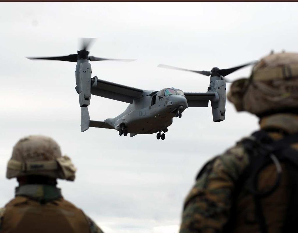
18 experienced 52,309 annual operations. However, annual flight operations are projected to increase at MCAS New River in the next 10- to 15-year planning period due to new mission programs associated with the U.S. Marine Corps initiative, including two new CH-53E Super Stallion squadrons and two new squadrons operating the AH-1W Super Cobra and UH-1N Huey rotary-wing aircraft. In addition, two new MV- 22B Osprey aircraft squadrons have replaced two CH-46E Sea Knight rotary-wing squadrons. MCAS New River is also projected to increase its operational levels due to planned increases in MV-22B training operations and the establishment of MARSOC at MCB Camp Lejeune. Section 3 presents more details on projected changes in operational levels at MCAS New River. Table 1-2 Comparison of Annual Operations at MCAS New River Calendar Year Marine Corps Other Military Civil General Aviation TOTAL , ,007 52, , ,609 60, , ,980 54, , ,069 43, , , , ,391 52, , ,209 53,394 Source: Wyle Changes in Aircraft Mix MCAS New River is utilized for a variety of military training and testing purposes. Activities involve the use of rotary-wing, tilt-rotor, and fixed-wing aircraft. The air station is the U.S. Marine Corps premier rotary-wing aircraft facility on the East Coast and is home to the Marine Corps MV-22B Osprey tilt-rotor aircraft. As mentioned in Section 1.5.1, the number of aircraft squadrons and the tempo of air operations are projected to increase at MCAS New River. Since 2001, a large portion of the aircraft utilizing MCAS New River has included the CH-53E Super Stallion rotary-wing and MV-22B Osprey tilt-rotor aircraft. In the next 10- to 15-year planning period, two new CH-53E Super Stallion squadrons and two new squadrons operating the AH-1W Super Cobra and UH-1N Huey rotary-wing aircraft will be added to MCAS New River. In addition, two new MV-22B Osprey aircraft squadrons have replaced two CH-46E Sea Knight rotary-wing 1-8
19 squadrons. The CH-46E rotary-wing aircraft no longer utilize MCAS New River. For the purposes of the noise analysis prepared for this AICUZ Study however, the final two squadrons of CH-46E were modeled. Although the CH-46E no longer operates at MCAS New River the noise profiles for the CH-46E are similar to the MV-22; thus, the CH- 46E serves as a surrogate for these final two squadrons that transitioned to the MV-22. All other MV-22 squadrons were modeled using MV-22 noise profile data and the full impact of the noise generation from the MV-22 has been captured in this analysis. Even with the addition of the new squadrons, the aircraft mix utilizing the air station will not be significantly different from the existing mix and will still be dominated by the CH-53E rotary-wing and MV-22B tilt-rotor aircraft. In addition, future transient operations can be expected to include the F-35B Lightning II, a short takeoff vertical landing (STOVL) version of the Joint Strike Fighter (JSF) as it comes online in the future. The F-35B will replace the AV-8B Harrier, which has conducted transient operations at MCAS New River in the past. Table 1-3 provides a comparison of MCAS New River s 2001 and 2011 aircraft mix. Table 1-3 Aircraft Mix, MCAS New River Number of Squadrons Aircraft Type Current 2001 AICUZ a 2011 AICUZ CH-53E UH-1N/AH-1W b CH-46E 2 0 c 2 c MV-22B Total Source: U.S. Marine Corps 2001; Wyle 2008 Note: a 2001 AICUZ projection for year 2015 squadron mix. b c Squadron includes both the UH-1N and AH-1W rotary-wing aircraft. The CH-46E was projected to be phased out at the end of the 2001 AICUZ study planning period (2015). The two squadrons were replaced by the MV-22 during the development of this AICUZ Study. This change has a negligible impact on the noise analysis Changes in Flight Tracks and Procedures Changes have occurred with regard to MCAS New River s arrival, departure, and touch-and-go flight tracks and procedures in recent years. The most significant changes have been the addition of six 1-9
20 new departure flight tracks with a combined 2,888 annual flight operations, and four new touch-and-go pattern tracks with a combined 76 annual flight operations. See Section 3.4 for specific flight tracks flown at MCAS New River. Flight tracks are provided for all fixed-wing, tilt-rotor, and rotary-wing aircraft. 1-10
21 2 MCAS New River 2.1 Location MCAS New River is located on the south bank of the New River, in eastern North Carolina, approximately 3 miles south of downtown Jacksonville, the county seat of Onslow County. The air station is comprised of approximately 3,728 acres within the northwestern portion of the larger 129,899-acre MCB Camp Lejeune complex. Figure 2-1 indicates the regional location of the air station. 2.2 Mission The mission of MCAS New River is to maintain and operate facilities and provide services and material to support ground combat forces located at MCB Camp Lejeune and perform such other air operations as requested. The station is the premier Marine Corps helicopter operating facility on the East Coast. Several major tenants of the air station conduct predominantly rotary-wing and tilt-rotor operations, including units of the 2 nd Marine Aircraft Wing (MAW), Marine Air Group (MAG) 26 and MAG 29, and their subordinate aircraft squadrons. Both MAGs provide direct aircraft support to U.S. Marine Corps Forces Command in the form of troop transport, observation, heavy lift capability, command and control, and light attack. Other major commands include Marine Corps Air Station Headquarters and Headquarters Squadron (H&HS), Marine Wing Support Squadron 272, Marine Air Control Squadron 2, the U.S. Air Force s 360 th Training Squadron Operating Location B, Marine Aviation Training Systems Site (MATSS) New River, and Marine Aviation Logistics Squadron (MALS) 26 and MALS History The history of MCAS New River began in 1941 when farmland was purchased by the U.S. government to build a military airfield. The airfield was placed under the command of MCB Camp Lejeune and 2-1


22 Ecology & Environment, Inc. GIS Department Project # NU04.02 \L:\Buffalo\New_River\Maps\MXD\Draft_AICUZ\January_2009\Figure 2-1 Regional Location Map.mxd Johnston County Newton Grove 13 Wayne County 70 Lenoir County Greene County Kinston Craven County Beaufort County Lowland 421 Sampson County Duplin County 258 Jones County Trenton MCOLF Oak Grove 55 Pamlico County Figure 2-1 Regional Location Map MCAS New River, NC 117 Rose Hill 24 MCAS New River Onslow County Jacksonville 17 MCB Camp Lejeune Havelock 70 Carteret County MCAS New River MCB Camp Lejeune MCOLF Oak Grove 701 Water Bodies County Boundaries 421 Bladen County Currie Pender County 17 Lake Waccamaw 74 Columbus County New Hanover County Wilmington T e n n e s s e e N o r t h C a r o li n a So u t h C ar o l in a A T L A N T I C O C E A N A l ab am a G e o r g i a Brunswick County GULF OF MEXICO F l o r i d a ATLANTIC OCEAN Source: ESRI, 2005 Southport Miles
23 received its first squadron, Marine Bombing Squadron-612, in In 1944, the airfield was officially commissioned as Peterfield Point, delineating the airfield from MCB Camp Lejeune. The airfield was briefly closed after World War II, but it was reopened in 1951 as Marine Corps Air Facility Peterfield Point, Camp Lejeune. In 1952, the facility was renamed Marine Corps Air Facility New River. MAG 26 was transferred to the air facility from MCAS Cherry Point in In 1968, the facility was designated Marine Corps Air Station (Helicopter) New River and became a major operational Marine Corps facility. A major Marine Corps reorganization occurred in 1972, and the station s airfield was named McCutcheon Field in honor of Brigadier General Keith B. McCutcheon. Since that time, MCAS New River has operated as a major Marine Corps rotary- and tilt-rotor operational facility. MCAS New River also has the distinction of being the only Marine Corps installation to house the new MV-22B Osprey, a tilt-rotor aircraft. Class A Runways Class A fixed-wing runways are used primarily by light aircraft and are not used intensively by heavy or high-performance aircraft. Typically, less than 10% of all operations involve heavy (e.g., C-130) or highperformance (e.g., F/A-18) aircraft. 2.4 McCutcheon Field MCAS New River s airfield, McCutcheon Field, is 26 feet above mean sea level (MSL). The airfield consists of two asphalt runways, 05/23 and 01/19. Runway 23 is the primary calm wind runway. MCAS New River s runways are designated as Class A fixed-wing runways, and they are also used by rotary-wing and tilt-rotor aircraft. In addition, there are six taxiways and seven mats (1 through 7). Mat 1 is the parking area for the air station s UC-12B Huron fixed-wing and transient aircraft. Runway arresting gear is not currently available at the air station (U.S. Marine Corps 2007). Table 2-1 provides the dimensions of the two runways, and Figure 2-2 illustrates their layout. Table 2-1 McCutcheon Field Runways Runway Length (feet) Width (feet) Runway 05/23 5, Runway 01/19 4, Source: U.S. Marine Corps


24 Ecology & Environment, Inc. GIS Department Project # NU04.02 \L:\Buffalo\New_River\Maps\MXD\Draft_AICUZ\January_2009\Figure 2-2 Airfield Map.mxd ST SCHMIDT WHITE STREET BANCROFT STREET DAVIS STREET CAMPBELL STREET MCAVOY STREET CURTIS ROAD FLOUNDER ROAD DEMARCOST DOUGLASS ROAD CANAL ST Mat 5 Mat 6 Mat 4 Mat 3 Mat N e w R i v e r Figure 2-2 McCutcheon Field Airfield Map MCAS New River, NC Water Bodies Mat 1 MCAS New River MCB Camp Lejeune Airfield Surface Area Mat 7 Runways 05 NORDELL S T R E ET OLD RAILROAD TRACK ROAD MCAS New River PERIMETER STREET 01 LONGSTAFF STREET PATRICK ST Source: ESRI, 2005 MCB Camp Lejeune ,000 2,000 Feet
25 2.5 Local Economic Impacts MCB Camp Lejeune and MCAS New River play a significant economic role at the state and local levels. The installations contribute directly to the economic development of the surrounding community through employment, capital investments, and defense contracting, and indirectly through increased demand for local goods and services and increased household spending by service members and military retirees. The installations are critical to the state and local economies, accounting for thousands of jobs and generating millions of dollars in economic activity and tax revenue. The total MCAS New River workforce for 2010 included 7,605 military and civilian employees. In addition, 1,986 retired military and 8,920 dependant family members reside in the area surrounding MCAS New River. In 2010, MCAS New River had a direct economic impact of nearly $483 million (U.S. Marine Corps 2010b). This included the salaries of active and retired military members and civilian employees, procurement, and construction activities. The jobs specifically associated with MCAS New River and the spending associated with both the workers and the facility ripple through the entire economy of eastern North Carolina. As a result, the military creates a stable and consistent source of employment and tax revenue for the local economy. Table 2-2 provides a summary of the total economic impact of MCAS New River. Table 2-2 FY 2010 MCAS New River Economic Impact Military Salaries Active $245,990,265 Retired $37,619,400 Civilian Salaries $36,348,223 Procurement $35,714,217 Construction $107,000,000 Other including Education and Contributions $20,286,055 Total $482,958,160 Source: U.S. Marine Corps 2010b 2-5
26 This page intentionally left blank. 2-6

27 3 Aircraft Operations Aircraft operations are the main source of noise at MCAS New River. Aircraft noise consists of two major sound sources: flight operations and ground engine maintenance run-ups, which are associated with pre-flight and maintenance checks. The level of noise exposure is related to a number of variables, including aircraft type, engine power settings, altitudes at which aircraft fly, direction of aircraft during run-ups, duration of run-ups, flight tracks, temperature, relative humidity, and frequency and time of operations. Generally, these factors fluctuate from year to year. Small fluctuations in the annual number of operations of like aircraft will not have a significant effect on community noise exposure. This section presents a brief overview of the types of aircraft that utilize MCAS New River, the organization of air station squadrons, aircraft operational areas, and a description of air operations, including the number of operations and flight tracks used to conduct the operations. 3.1 Aircraft Types MCAS New River is utilized primarily by rotary-wing and tiltrotor aircraft. Below is a representation of some of the aircraft that are proposed to operate at MCAS New River Rotary-wing Aircraft CH-53E Super Stallion. The Super Stallion is the largest helicopter in the U.S. military inventory. It is used by the Marine Corps to transport personnel and equipment and heavy-lift external loads. With its maximum lift capability of 16 tons, the CH-53E is the only helicopter capable of lifting some of the Marine Corps new weapon systems, including the M-198 Howitzer and the variants of the Light Armored 3-1

28 Vehicle. The CH-53E will be replaced by the CH-53K Super Stallion Heavy Lift Replacement beginning in FY2017, which will provide even greater lift capacity than the CH-53E variant. AH-1W Super Cobra. The Super Cobra is a day/night marginal weather Marine Corps attack helicopter that provides en route escort for assault helicopters and their embarked forces. It has an air-toair and precision guided munitions capabilities. The primary mission of the AH-1W aircraft is as an armed tactical helicopter capable of close air support, low-altitude and high-speed flight, target search and acquisition, reconnaissance by fire, multiple weapons fire support, troop helicopter support, and point target attack of threatening armor. The AH-1W provides fire support and fire support coordination to landing forces during amphibious assaults and subsequent operations ashore. The AH- 1W will be upgraded to the AH-1Z beginning in 2015, which will provide the aircraft with a four-blade rotor, improved avionics, up-rated transmission and a new targeting system. UH-1N Huey. The UH-1Ns are widely used in transport, airborne battlefield command and control, troop insertion/extraction, fire support coordination, medical evacuation, search and rescue, armed escort/visual reconnaissance, and utility roles throughout the Navy and Marine Corps. The Huey provides utility combat helicopter support to the landing force commander during ship-to-shore movement and in subsequent operations ashore. Like the AH-1W, the UH-1N is undergoing modernization. It will be replaced by the UH-1Y beginning in 2011, with a four-blade rotor system. The Y model includes an upgraded rotor system, engine, and transmission for increased payload capabilities, greater range, and a higher maximum cruise speed than the UH-1N. 3-2

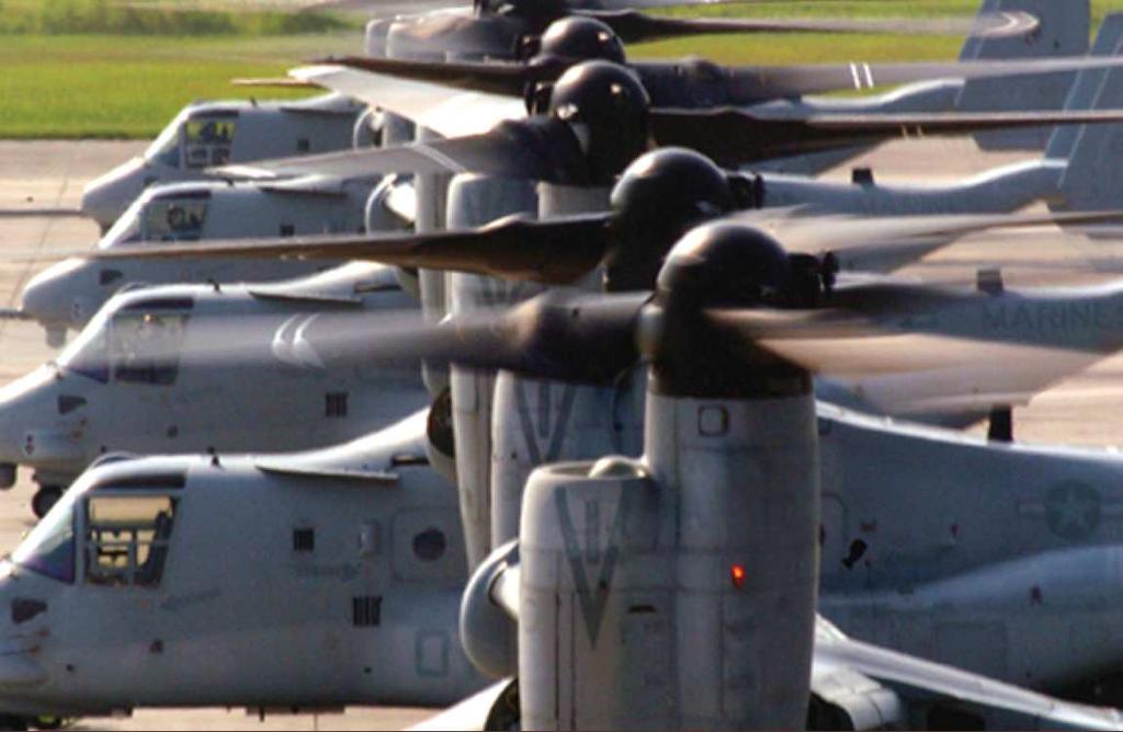
29 3.1.2 Tilt-rotor Aircraft MV-22B Osprey. The Osprey is a joint-service, multi-mission, tilt-rotor aircraft with vertical take-off and landing capability. It performs vertical take-off and landings as effectively as a conventional helicopter and has the long-range cruise abilities of a twin-turboprop aircraft. It is an assault transport for troops, equipment, and supplies and is capable of operating from ships or from expeditionary airfields ashore. The Osprey replaced the CH-46E at MCAS New River and has a greater range, speed, ceiling, and payload than its predecessor Fixed-wing Aircraft AV-8B Harrier II. The AV-8B is a vertical and/or short takeoff and landing (V/STOL) strike aircraft. The aircraft is a single-seat, light attack aircraft that provides offensive air support to Marine Corps ground forces. The V/STOL capability is unique and allows the AV-8B to operate from a variety of ships, expeditionary airfields, forward site or damaged airfields. The AV-8B is being replaced with the F-35B Lightning II aircraft at MCAS New River beginning in approximately No AV-8B aircraft are homebased at MCAS New River. They are transient to the airfield with limited operations. F-35B Lightning II (Joint Strike Fighter). The F-35B is the Marine Corps variant of the JSF. The aircraft is a highly advanced, single-engine, single-seat, stealth, supersonic, multi-role strike-fighter aircraft that can take off from conventional runways, amphibious ships, and unimproved surfaces. Its unique short takeoff vertical landing (STOVL) technology enables the F-35B to take off and land vertically and operate as a fixed-wing jet aircraft once airborne. No F-35B aircraft will be homebased at MCAS New River. They will be transient to the airfield with limited operations. 3-3


30 UC-12B Huron. The UC-12B is the U.S. Navy/Marine Corps version of the King Air A200C, a twin-turboprop, fixed-wing aircraft. The basic mission of the UC-12B aircraft is to provide on-call 24-hour, 7-day-a-week transportation of passengers and/or light cargo. The UC- 12B will be upgraded to the UC-12W at MCAS New River beginning in C-130 Hercules. The Hercules is a four-turboprop aircraft whose multi-role, multi-mission includes tactical tanker/transport, aerial refueling, aerial delivery of troops and cargo, emergency resupply, emergency medical evacuation, tactical insertion of combat troops and equipment, and evacuation missions. No C-130 aircraft are homebased at MCAS New River. They are transient to the airfield with limited operations. 3.2 Squadron Organization MCAS New River is home to Marine Air Group (MAG) 26 and MAG 29 and their subordinate aircraft squadrons, including: Two CH-53E heavy-lift fleet squadrons (HMH-461 and HMH-264); One CH-53E Fleet Replacement Squadron (FRS) (HMT- 302); Two UH-1N/AH-1W light/attack fleet squadrons (HML/A- 167 and HML/A-269); Seven MV-22B squadrons (VMX-22, VMM-162, VMM- 261, VMM-263, VMM-264, VMM-266, and VMM-365); and One MV-22B FRS (VMMT-204). New mission programs associated with the U.S. Marine Corps initiative are also scheduled to come online at MCAS New River in the next 10- to 15-year planning period. These new mission programs include the following: Two new CH-53E squadrons (HMH-366 and a currently unnamed squadron); and 3-4
31 Two additional UH-1N/AH-1W light/attack fleet squadrons (HML/A-467 and HML/A-567). 3.3 Operational Areas MCAS New River aircraft presently conduct training operations in the areas to the north and west of the air station. The local flying area for rotary-wing aircraft is an area extending 100 nautical miles (NM) in radius from MCAS New River (but not extending beyond the coast of the Atlantic Ocean). The local flying area for fixed-wing and tilt-rotor aircraft is an area extending 350 NM in radius from MCAS New River (but not extending beyond the coast of the Atlantic Ocean). Airspace is the threedimensional space above the earth s surface. Airspace is a finite resource and is managed by the FAA for the benefit and use of all aviation sectors needing access to it commercial, general, and military. Controlled Airspace Controlled airspace is divided into six classes, A through E and G. These six classes identify airspaces that support airport operations and designated airways, affording en route transit from place to place. In addition, these classes also dictate pilot qualification requirements, rules of flight that must be followed, and the type of equipment necessary to operate within an airspace class. Special Use Airspace The SUA designation alerts nonparticipating aircraft (civil or military) to the possible presence of military activity or unusual flight conditions. Restricted Areas Restricted areas define airspace where the flight of aircraft, while not wholly prohibited, is subject to restrictions. Restricted areas denote the existence of unusual, often invisible, hazards to aircraft such as artillery firing, aerial gunnery or guided missiles Airspace The use of airspace over MCAS New River is dictated by the Federal Aviation Administration (FAA) National Airspace System. This system is designed to ensure the safe, orderly, and efficient flow of commercial, private, and military aircraft. MCAS New River is located in airspace assigned to Washington Center by the FAA. Washington Center has delegated control of local airspace to Cherry Point Approach Control. Cherry Point has, in turn, delegated control of local airspace to the New River Radar Facility by Letter of Agreement. MCAS New River aircraft utilize the airspace around MCAS New River, which includes Class D and E airspace and four special use airspace (SUA) areas. The areas are graphically depicted on Figure 3-1 and are described below: MCAS New River Class D Surface Area the airspace extending upward from the surface to and including 2,500 feet MSL within a 5-mile radius of MCAS New River. Class E Airspace Extension the airspace extending upward from the surface within 3.2 miles each side of New River TACAN 239 radial, extending from the 5-mile radius of MCAS New River to 7 miles southwest of the TACAN. MCAS New River/Albert J. Ellis Airport/Onslow Memorial Hospital Class E Airspace the airspace extending upward from 700 feet or more above the surface within a 6.4-mile radius of the Albert J. Ellis Airport, and within a 6-mile radius of the point in space serving Onslow Memorial Hospital. 3-5
32 Restricted Area (R-) 5303A/B/C Surface up to 17,999 feet. R-5304A/B/C Surface up to 17,999 feet. R-5306D/E Surface up to 17,999 feet. Military Operations Areas MOAs consist of airspace of defined vertical and lateral limits established for the purpose of separating certain military training activities (such as air combat maneuvers, intercepts, acrobatics, etc.) from instrument flight rules (IFR) air traffic. Nonmilitary aircraft are not prohibited from operating within the boundaries of an MOA. Military Operations Area (MOA) Hatteras F 3,000 feet to 13,000 feet. Additional information regarding MCAS New River airspace is outlined in ASO P3710.7T, Marine Corps Air Station New River Air Operations Manual (U.S. Marine Corps 2009) Low Work Areas Low work operations consist of rotary-wing aircraft hover work and other low-altitude training operations. They are conducted in designated areas within the boundary of MCAS New River at altitudes less than 50 feet above ground level (AGL). At MCAS New River, there are two different areas of the airfield for low work operations the Midfield Hover Area and the Northeast Grass Area. The Midfield Hover Area comprises three separate sites: Midfield Hover Area West (MDW), Midfield Hover Area North (MDN), and Midfield Hover Area East (MDE). The Northeast Grass Area comprises two sites: Northeast Grass Area North (NGN) and Northeast Grass Area South (NES). Figure 3-2 identifies the locations of these five low work areas. 3.4 Aircraft Operations The main noise sources at MCAS New River are aircraft operations, including flight arrivals, departures, pattern work, and low-level activities (i.e., hovers). Engine maintenance operations, or run-ups, also contribute to noise at MCAS New River. 3-6


33 Ecology & Environment, Inc. GIS Department Project # NU04.02 \L:\Buffalo\New_River\Maps\MXD\Draft_AICUZ\January_2009\Figure 3-1 Airspace.mxd Craven Duplin 258 Onslow Jones Havelock Albert J. Ellis Airport MCAS New River Jacksonville Onslow Memorial Hospitol MCB Camp Lejeune Carteret 70 Figure 3-1 Airspace MCAS New River, NC Civilian Airport Airspace Class Class D R-5303A/B/C Class E R-5304A/B/C R-5306E R-5306D Special Use Airspace MOA Restricted Area Water Bodies County Boundary Pender Hatteras F MOA 117 A T L A N T I C O C E A N 17 Source: ESRI, 2005 New Hanover Miles


34 A STREET Ecology & Environment, Inc. GIS Department Project # NU04.02 \L:\Buffalo\New_River\Maps\MXD\Draft_AICUZ\January_2009\Figure 3-2 Low Work Areas.mxd MCB Camp Lejeune JONES ST REE T MCB Camp Lejeune ROAD HICKS RUN CURTIS ROAD DOUGLASS ROAD SCHMIDT ST PERIMETER STREET CAMPBELL STREET DEMARCO ST CANAL ST WHITE STREET Mat 7 BANCROFT STREET Mat 5 Mat 6 MCAVOY STREET SUMNER STREET AGAN STREET Mat 4 Mat 2 Mat 3 NEN NES MDN FLOUNDER ROAD LONGSTA F STREET Mat 1 N e w R i v e r Figure 3-2 Low Work Areas MCAS New River, NC Prospective Engine Maintenance Test Cell Low Work Area Water Bodies MCB Camp Lejeune MCAS New River Airfield Surface Area MDW CURTIS Runways MCB Camp Lejeune OLD RAILROAD TRACK ROAD 05 MDE PERIMETER STREET MCAS New River 01 ROAD NORDELL ST R E ET Source: ESRI, 2005 PERIMETER ROAD MCB Camp Lejeune RAGGED POINT ROAD Miles
35 3.4.1 Flight Operations A flight operation refers to anytime an aircraft crosses over the runway threshold of an airfield. Rotary-wing, tilt-rotor, and fixed-wing flight operations at MCAS New River include the following: Departure. An aircraft taking off to a local training area, a non-local training area, or as part of a training maneuver. Arrival (straight-in/full-stop). An aircraft lines up on the runway centerline, descends gradually, lands, comes to a full stop, and then taxis off the runway. Overhead Arrival. An expeditious arrival using visual flight rules. An aircraft approaches the runway 500 feet above the altitude of the landing pattern. Approximately halfway down the runway, the aircraft performs a 180- degree turn to enter the landing pattern. Once established in the pattern, the aircraft lowers landing gear and flaps and performs a 180-degree descending turn to land on the runway. Ground Control Approach (GCA). A radar or talk down approach directed from the ground by air traffic control (ATC) personnel. ATC personnel provide pilots with verbal course and glide slope information, allowing them to make an instrument approach during inclement weather. Touch-and-Go Operation. An aircraft lands and takes off on a runway without coming to a full stop. After touching down, the pilot immediately goes to full power and takes off again. The touch-and-go is counted as two operations the landing is counted as one operation, and the takeoff is counted as another Annual Aircraft Operations Projections of aircraft operations are based upon currently available estimates of future mission requirements within the next 10- to 15-year planning period. The projected average number of future operations at MCAS New River, including arrivals, departures, overhead arrivals, and pattern operations, is 92,711 per year (Wyle 2008). An operation consists of any time an aircraft crosses over the runway threshold. Consequently, while a takeoff or a landing are each counted as a single operation, a pattern counts as two. The majority of projected air operations at MCAS New River involve rotary-wing and tilt-rotor aircraft, 74% and 24%, respectively. Approximately 2% of all 3-9
36 operations involve fixed-wing aircraft. The principal aircraft operating at MCAS New River are the CH-53E Super Stallion helicopter (35%) and the MV-22B Osprey (24%). Other airframes that contribute to the airfield s operations include the UH-1N Huey (15%) and the AH-1W Super Cobra (15%). Most fixed-wing operations at MCAS New River involve transient aircraft. The only fixed-wing aircraft homebased at MCAS New River is the UC-12B Huron. Future fixed-wing aircraft that may utilize the airfield include the C-130 Hercules and the F-35B Lightning II JSF (which is replacing the AV-8B). Figure 3-3 identifies the mix of aircraft projected to utilize MCAS New River. Projected annual flight operations per aircraft are shown in Table 3-1. The projections of future operations are conservative forecasts, are higher than operational levels in recent years, and are used solely for future planning purposes. Fixed-Wing, 2% CH-46E, 9% MV-22B, 24% CH-53E, 35% UH-1N, 15% AH-1W, 15% Source: Wyle 2008 Note: At the time of the noise study (2008), two squadrons of CH-46E aircraft were still stationed at MCAS New River. They have since been replaced by MV-22B aircraft. Figure 3-3 Aircraft Mix, MCAS New River (2009) 3-10
37 Table 3-1 Projected Annual Flight Operations at MCAS New River Departure Arrival Overhead Arrival GCA 1 Touch and Go 1 TOTAL Aircraft Type Total Total Total Total Total Total MCAS New River Aircraft CH-46E 2 3, ,306 2, , , ,816 CH-53E 12, ,990 11,965 1,025 12, , ,000 30,685 2,110 32,795 AH-1W 4, ,840 3,840 1,000 4, , ,532 12,020 1,644 13,664 UH-1N 4, ,084 4,084 1,000 5, , ,532 12,516 1,644 14,160 MV-22B 8, ,936 7, , , ,088 3, ,528 20,864 1,624 22,488 UC-12B , ,294 Transient Aircraft F-35B C Other Transient Jet Aircraft 3 Total 33,860 2,080 35,940 30,753 3,997 34,750 1, ,192 2, ,259 16,410 1,220 17,630 84,953 7,818 92,771 1 Counted as two operations, a takeoff, and a landing. 2 The CH-46 aircraft previously stationed at MCAS New River during development of the noise study have since been replaced by MV-22 aircraft. This change would have a negligible impact on the overall noise contour presented in this AICUZ Study. 3 The C-500 (Cessna Citation) was used to represent other transient jet aircraft operating at MCAS New River (Wyle 2008). Source: Wyle
38 Flight tracks are represented as single lines, but the actual flight path varies depending on aircraft performance, pilot technique, and weather conditions Runway and Flight Track Utilization Runway utilization by tilt-rotor and rotary- and fixed-wing aircraft at MCAS New River is shown in Table 3-2. Rotary-wing and tilt-rotor aircraft also utilize the low work areas identified in Section Aircraft approaching or departing from the air station are assigned specific routes or flight tracks. The designated runways for the airfield are identified in Section 2.4. Flight tracks are represented as single lines, but actual flight paths vary due to aircraft performance, pilot technique, and weather conditions, such that the actual flight track is a band, often one-half to several miles wide. The flight tracks presented in this AICUZ study are idealized representations. Figures 3-4 through 3-6 illustrate the major departures, arrivals, and pattern flight tracks for tiltrotor and rotary- and fixed-wing aircraft operating at MCAS New River. Table 3-2 Runway Utilization, MCAS New River Runway 1 6% 5 17% 19 16% 23 61% Source: Wyle 2008 Utilization Low Work and Maintenance Run-Up Operations Table 3-3 presents the annual low work operations by location and aircraft type. Approximately 4,854 low work operations are projected to occur per year, with 86% occurring at the Midfield Hover Area. The average duration of a low work operation is between three and five minutes. 3-12


39 US ROUTE 17 Ecology & Environment, Inc. GIS Department Project # NU04.02 \L:\Buffalo\New_River\Maps\MXD\Draft_AICUZ\January_2009\Figure 3-4 Arrival Flight Tracks.mxd LEJEUNE EDWARDS BRUCE IVES BURGAW ONSLOW MURRILL HILL HUMPHREY PICKETT VANDERGRIFT MAPLEHURST PINES 01A4 05A4 EDITH 23A4 OLD LINDSEY MELODY 19A4 JONATHAN FURIA MAPLEHURST BAILEY BAILEY RIGGS WILMINGTON HICKS RUN R OA D BLUE CREEK SCHOOL CANADY US 17 ROUTE CURTIS ROAD MCAS New River DOUGLASS ROAD CHURCH STREE T SCHMIDT ST ST CANAL ST DEMARCO WHITE STREET Mat 7 Mat 4 Mat 2 Mat 5 Mat 3 Mat 6 AGAN STREET 19A CU RTIS ROAD Jacksonville Bypass 19A1 Mat 1 19A2 23A5 MCB Camp Lejeune WILSON CO.ST REET B ROAD FRASER ROAD 23A1 05A1 CAM P KNOX ROAD Figure 3-4 Arival Flight Tracks MCAS New River, NC Arrival Flight Tracks Runways MCAS New River MCB Camp Lejeune Water Bodies RIDGE OLD RAILROAD TRACK ROAD 05 PERIMETE R STREET 01 23A2 01A2 N e w R i v e r DAWSON CABIN KANTON HENDERSON WILMINGTON HI C KS RUN ROAD 05A2 HIGH HILL SEWELL MALLARD STELLER MANDARIN SOUTH CREEK EIDER US ROUTE 17 05A5 05A3 MET TROAD 05A1 PERIMETER ROA D VERONA LOOP ROAD 01A3 23A3 19A3 MCB Camp Lejeune RAGGED POINT ROA D 19A2 Source: Wyle, Miles


40 19D5 01D5 Ecology & Environment, Inc. GIS Department Project # NU04.02 \L:\Buffalo\New_River\Maps\MXD\Draft_AICUZ\January_2009\Figure 3-5 Departure Flight Tracks.mxd JOES BURGAW CO UN TRY TEE BRUCE IVES WOOD ONSLOW MAPLE HUR ST MURRILL HILL HUMPHREY PICKETT VANDERGRIFT PINES EDITH OLD LINDSEY MELODY 01D4 05D4 JONATHAN FURIA MAPLEHURST B AILEY BAILEY RIGGS 19D7 WILMINGTON HICKS RUN R OA D 23D4 BLUE CREEK SCHOOL 19D4 CANADY US 01D6 MCAS New River 19D6 ROUTE 17 CURTIS ROAD DOUGLASS ROAD CHURCH STRE ET SCHMIDT ST 05D6 ST CANAL ST DEMARCO WHITE STREET Mat 7 BAXTER ERASTUS GRIER MORTHS MCAVOY Mat 4 Mat 2 Mat 5 Mat 3 Mat 6 AGAN STREET LOYOLA FLOUNDER RO A D CU RTIS ROAD Jacksonville Bypass LONGSTAFF Mat 1 WAR DOLA B A Y SHORE 01D3 01D1 05D5 MCB Camp Lejeune MONTFORD LANDING WILSON CO.ST REET B ROAD FRASER ROAD 05D1 23D1 19D1 01D1 LEJEUNE CAMP KNOX Figure 3-5 Departure Flight Tracks MCAS New River, NC Departure Flight Tracks Runways MCAS New River MCB Camp Lejeune Water Bodies RIDGE 23D7 23D6 OLD RAILROAD TRACK ROAD 05 PERIMETE R STREET 01 TA F F L O N G S N e w R i v e r KANTON MILLS HIGH HILL STRAW BERRY MORRIS DAWSON CABIN HENDER SON WILMINGTON M WIG EON PEK IN STEL LER HI C KS RUN AL LARD MANDA RIN CREEK EIDER ROAD US ROUTE 17 23D5 23D3 MET T ROAD PERIMETER ROA D 19D3 23D1 05D3 01D3 23D2 RAGGED POINT ROA D MCB Camp Lejeune 05D2 01D2 05D2 Source: Wyle, SEWELL SOUTH VERONA LOOP Miles


41 WILMINGTON 01G1 01T1 Ecology & Environment, Inc. GIS Department Project # NU04.02 \L:\Buffalo\New_River\Maps\MXD\Draft_AICUZ\January_2009\Figure 3-6 Closed Pattern Flight Tracks.mxd JOES BURGAW CO UN TRY TEE WOOD VANDERGRIFT MAPLE HURST EDITH OLD LINDSEY MELODY FURIA MAPLEHURST BLUE CREEK SCHOOL CANADY US ROUTE 17 ERASTUS MORTHS LOYOLA WAR DOLA B A Y SHORE CO.STREET B LEJEUNE BRUCE IVES ONSLOW PINES JONATHAN RIGGS BAILEY WILMINGTON CURTIS ROAD CHURCH STREE T BAXTER 05G1 GRIER MCAVOY AGAN STREET 19G1 FLOUNDER RO AD Jacksonville Bypass 23G1 MONTFORD LANDING WILSON ROAD FRASER ROAD 01G1 CAMP KNOX Figure 3-6 Closed Pattern Flight Tracks MCAS New River, NC RIDGE MURRILL HILL HUMPHREY PICKETT US ROUTE 17 23G1 HICKS RUN ROAD DOUGLASS ROAD OLD RAILROAD TRACK ROAD SCHMIDT ST ST CANAL ST DEMARCO WHITE STREET Mat 7 05T1 Mat 4 Mat 5 Mat 6 05 Mat 3 PERIMETE R STREET Mat CU RTIS ROAD LONGSTAFF Mat 1 05T1 23T1 N e w R i v e r Closed Pattern Flight Tracks Runways MCAS New River MCB Camp Lejeune Water Bodies KANTON STRAW BERRY DAWSON CABIN HENDERSON 19G1 MILLS MORRIS M ALLARD M ANDA RIN US ROUTE 17 05G1 MET TROAD PERIMETER ROA D RAGGED POINT ROA D Source: Wyle, WIG EON PEK IN STELL ER CREEK EIDER HIGH HILL SEWELL SOUTH VERONA LOOP Miles
42 Location Midfield Hover Area Northeast Grass Area Source: Wyle 2008 Table 3-3 Projected Low Work Operations at MCAS New River East North West North South Aircraft Type 1 Annual Number of Low Work Operations CH-46E CH-53E AH-1W UH-1N MV-22B CH-46E CH-53E AH-1W UH-1N Average Time (min) per Activity MV-22B CH-46E CH-53E AH-1W UH-1N MV-22B MV-22B CH-46E MV-22B CH-46E Total 5, The CH-46 aircraft previously stationed at MCAS New River during development of the noise study have since been replaced by MV-22 aircraft. This change would have a negligible impact on the overall noise contour presented in this AICUZ Study. Maintenance run-ups associated with maintenance operations are projected to take place in a new maintenance test cell facility located to the west of Runway 05/23. Construction of the new facility will enable all engine maintenance operations to be completed indoors. Run-ups are projected to last from 90 to 105 minutes, and it is expected that 944 engine maintenance operations will occur per year. Approximately 897 maintenance run-ups are expected to occur between the hours of 7:00 A.M. and 10:00 P.M., and approximately 47 run-ups are expected to occur between 10:00 P.M. and 7:00 A.M. 3-16
43 4 Aircraft Noise The identification of areas impacted by aircraft noise is a critical factor when planning land uses in the vicinity of air facilities. Because the noise from aircraft operations can significantly impact areas surrounding an installation, MCAS New River has prepared noise exposure contours that define land areas adjacent to the airfield that may experience noise impacts. This section discusses these noise contours and compares them to the contours identified in the 2001 AICUZ study. This section also describes how the contours were developed, how noise complaints are handled, and specific flight procedures MCAS New River has enacted to reduce noise impacts. A-weighted Decibel Places a greater emphasis on frequencies that are detected by people with a normal auditory range by de-emphasizing the very low and very high frequency components of sound. 4.1 What is Sound/Noise? All sounds come from a sound source. It takes energy to produce this sound, and this energy is transmitted through the air in sound waves. These sound waves impinge upon our ears, creating the sound we hear. Unwanted sound is defined as noise. Examples of potential sources of noise include roadway traffic, construction activities, railway activities, and aircraft operations. Whether sound becomes noise depends on the listener, but sound can become noise when it interferes with normal activities. In this study, all sound or noise levels are measured in A-weighted decibels (dba), which are units of sound pressure adjusted to the range of human hearing. Normal speech has a noise level of approximately 60 dba. Generally, sound levels above 120 dba will begin to provide discomfort to the human auditory system with the threshold of pain at about 140 dba (Berglund and Lindvall 1995). The noise exposure from aircraft at MCAS New River, as with other military installations, is measured using the day-night average sound level noise metric (DNL). The DNL metric, established in
44 by the Federal Interagency Committee on Urban Noise (FICUN), presents a reliable measure of community sensitivity to aircraft noise and has become the standard metric used in the United States (except California, which uses a similar metric, the Community Noise Equivalent Level). The DNL, expressed in decibels, represents the average sound exposure during a 24-hour period and does not represent the sound level for a specific noise event. The DNL also incorporates an additional 10 decibels to events occurring between 10:00 P.M. and 7:00 A.M. This 10- decibel penalty represents the added intrusiveness of sounds occurring during normal sleeping hours, both because of the increased sensitivity to noise during those hours and because ambient sound levels at night are typically lower. The DNL provides a single measure of overall noise impact by combining factors most noticeable about noise annoyance, including maximum noise levels and number of events over a 24-hour period. Scientific studies and social surveys conducted to evaluate community annoyance from many types of environmental noise have found the DNL to be the best measure of that annoyance (Federal Interagency Committee on Urban Noise 1980; U.S. Environmental Protection Agency 1982; American National Standards Institute 1990; Federal Interagency Committee on Noise 1992). Although DNL provides a single measure of overall noise impact, it does not provide specific information on the number of noise events or the individual sound levels that occur during the day. For example, a DNL of 65 dba could result from a very few noisy events or a large number of quieter events. 4.2 Airfield Noise Sources The main sources of noise at airfields are flight and maintenance run-up operations. Computer models are used to develop noise exposure contours based on information about these operations, including: Type of operation (arrival, departure, and pattern); Number of operations per day; Time of operation; 4-2
45 Flight track; Aircraft power settings, speeds, and altitudes; Number and duration of maintenance run-ups; Terrain; Surface type (e.g., land or water); and Environmental data (temperature and humidity). 4.3 Noise Complaints Aircraft noise has the potential to impact the quality of life of those experiencing it and can become a major compatibility issue for an air station and the surrounding community. Individual response to noise levels varies and is influenced by many factors, including: Activity the individual is engaged in at the time of the noise event; General sensitivity to noise; Time of day; Length of time an individual is exposed to noise; Predictability of noise; and Weather conditions. A small change in dba will not generally be noticeable. As the change in dba increases, the individual perception is greater, as shown in Table 4-1. Table 4-1 Subjective Response to Noise Change Change in Perceived Loudness +1 dba Requires close attention to notice +3 dba Barely noticeable +5 dba Quite noticeable +10 dba Dramatic twofold change +20 dba Striking fourfold change To mitigate adverse noise conditions, MCAS New River continually reviews its airfield operating activities with the aim of minimizing potential noise impacts on the surrounding community. If a 4-3
46 noise concern arises, members of the public may call the MCB Camp Lejeune 24-hour Noise Complaint Hotline ( ) or MCAS New River Operations ( ) to report a concern. MCAS New River Operations personnel are responsible for collecting, documenting, and researching noise complaints. All noise complaints are investigated by the MCAS New River Operations personnel, and corrective actions are taken, as appropriate. Noise complaint procedures for MCAS New River are established in ASO P3710.7T, Marine Corps Air Station New River Air Operations Manual. 4.4 Noise Abatement Procedures at MCAS New River In recognition of community response to aircraft noise, MCAS New River actively employs operational measures to reduce noise to the extent practicable, commensurate with safety and operational training requirements. Noise abatement procedures are contained in ASO P3710.7T, Marine Corps Air Station New River Air Operations Manual (U.S. Marine Corps 2009). The manual establishes the rules and regulations that apply to aircraft operating in the airspace under the control and cognizance of MCAS New River and vehicle operations on the airfield movement areas (e.g., runway, taxiways). The following are operational noise abatement procedures that have been adopted at MCAS New River: Pilots operating from MCAS New River shall be sensitive to the effects of noise on the surrounding communities and take all steps necessary to reduce aircraft noise and minimize annoyance experience by persons on the ground. It is not enough that the pilot is satisfied that persons/property are not endangered. Pilots shall make a definite effort to fly in a manner such that individuals on the ground do not believe they or their property is endangered. Pilots shall avoid overflight of populated areas to the maximum extent practicable. When overflying populated areas, pilots shall maintain a minimum altitude of 1,000 feet AGL unless the local course rules specify a lower altitude. ATC shall not authorize close-in downwind patterns after sunset. 4-4
47 ATC shall not authorize use of the local traffic pattern after 11 P.M. 4.5 Noise Exposure Contours In support of this AICUZ study, a noise study was conducted to define noise exposure contours at MCAS New River. The noise exposure contours were prepared using NOISEMAP, a widely accepted computer model that projects noise impacts around military airfields. Using NOISEMAP, the Marine Corps models noise exposure contours based on prospective aircraft activity at the installation and site-specific operational data such as flight tracks, type and mix of aircraft, aircraft profiles (airspeed, altitude, power settings), and frequency and times of operations. The noise exposure contours graphically illustrate where aircraft noise occurs in and around an airfield and at what sound level. The contours generally follow the flight paths of aircraft. The noise contours are depicted in 5-dBA increments (60, 65, 70, 75, 80, and 85 DNL). The DNL is depicted visually as a noise exposure contour that connects points of equal value. For land use planning purposes, the contours are divided into the following three noise zones: Noise Zone 1 (64 DNL and below) 1 Generally considered an area of low or no noise impact; Noise Zone 2 (65 to 74 DNL) An area of moderate impact requiring some land use controls; and Noise Zone 3 (75 DNL and above) The most severely impacted area and requiring the greatest degree of land use control. Land use compatibility information and recommendations for MCAS New River are presented in Sections 6 and 7, respectively AICUZ Noise Exposure Contours The 2011 AICUZ noise exposure contours for MCAS New River are shown on Figure 4-1. The contours are located primarily within the 1 For purposes of analysis in the AICUZ study, Noise Zone 1 is analyzed between the 60 to 64 DNL noise contours. 4-5
48 Ecology & Environment, Inc. GIS Department Project # NU04.02 \Path: L:\Buffalo\New_River\Maps\MXD\Draft_AICUZ\January_2009\Figure Noise Contours Rev02 Feb2011.mxd Onslow County City of Jacks onvi ll e Figure AICUZ Noise Exposure Contours MCAS New River, NC MCAS New River MCB Camp Lejeune Church Noise Zone Public School 2011 AICUZ Noise Contour Water Bodies Zone Zone 2 Zone 3 MCB Camp Lejeune 60 N e w R i v e r MCAS New River MCB Camp Lejeune 60 Source: ESRI, 2005; MCAS New River, 2008; USMC GEOFidelis Miles
49 boundaries of MCAS New River and MCB Camp Lejeune or overlie the New River, a natural water body. Three arms of the 2011 AICUZ noise exposure contours, encompassing approximately 2,594 acres, extend outside of the MCAS New River and MCB Camp Lejeune property line. The majority of the noise exposure contours located off-base, encompassing approximately 2,572 acres, are within the 60 to 64 DNL noise zone (Noise Zone 1). A smaller portion, encompassing approximately 22 acres, is within the 65 to 70 DNL noise zone contour (a portion of Noise Zone 2). No noise contour greater than 70 DNL has been identified outside of the MCAS New River and MCB Camp Lejeune property line. The arm extending over the western boundary of MCAS New River is a result of the projected fixed-wing departures, most notably the transient F-35B aircraft operations (Wyle 2008). The arms extending over the northeastern and southern boundaries of MCB Camp Lejeune are a result of rotary-wing aircraft departures and arrivals. Rotary-wing aircraft depart MCAS New River airspace by climbing to 1,000 feet AGL and, once outside of the MCAS New River airspace, descending to 500 feet AGL to continue on their flight route. The land parcels underlying these noise zones are zoned for residential, business, and agricultural land uses. Land use compatibility information and recommendations for MCAS New River are presented in Sections 6 and 7, respectively Comparison of 2001 AICUZ and 2011 AICUZ Noise Exposure Contours This section compares the 2011 AICUZ noise exposure contours to the previous contours published in the 2001 AICUZ study. The comparison helps identify changes to noise exposure based on prospective changes in aircraft operations and allows the targeting of land use recommendations to mitigate noise impacts. A comparison of 2001 AICUZ and 2011 AICUZ noise contours at MCAS New River indicates a reduction in overall noise exposure outside of the installation boundary (see Figure 4-2). Compared to the 2001 AICUZ noise contours, the 2011 AICUZ noise exposure contours move away from the northern and western borders of MCAS New River and are focused mostly over the airfield and the New River. Overall, the 4-7
50 Ecology & Environment, Inc. GIS Department Project # NU04.02 \L:\Buffalo\New_River\Maps\MXD\Draft_AICUZ\January_2009\Figure Noise Contours Rev01.mxd 04/15/2009 Onslow County Cit y of Ja ckso nville MCB Camp Lejeune 60 Figure 4-2 Comparison of 2001 and 2011 AICUZ Noise Exposure Contours MCAS New River, NC Church Public School 2001 AICUZ Noise Contour 2011 AICUZ Noise Contour Water Bodies 60 ZONE MCB Camp Lejeune N e w R i v e r Zone 1 Zone 2 Zone 3 MCAS New River MCB Camp Lejeune 60 Source: ESRI, 2005; MCAS New River, 2008; USMC GEOFidelis Miles
51 area covered by the noise zones decreased by approximately 100 acres between 2001 and 2011, as shown in Table 4-2. Table 4-2 Comparison of Land Area within Noise Zones, MCAS New River 1 TOTAL LAND AREA Noise Zone (DNL) 2001 AICUZ (acres) 2011 AICUZ (acres) Noise Zone 1 (64 DNL and below) 2 12,923 11,542 Noise Zone 2 (65 to 74 DNL) 1,689 3,089 Noise Zone 3 (75 DNL and above) Total 14,823 14,723 Source: Wyle Includes land areas both on- and off-station For purposes of analysis in the AICUZ study, Noise Zone 1 is analyzed between the 60 to 64 DNL noise contours. 4-9
52 This page intentionally left blank. 4-10
53 5 Airfield Safety This section describes airfield-specific Accident Potential Zones (APZs) and airfield safety issues such as imaginary surface areas, the Bird Aircraft Strike Hazard (BASH) Program, and measures to avoid other hazards within the airfield vicinity that can obstruct or interfere with aircraft operations, pilot vision, communications, or aircraft electronics. 5.1 Accident Potential Zones In the 1970s, the DoD conducted a tri-service study of historic aircraft accident data to identify accident potential in the areas surrounding military airfields. The study found that more aircraft mishaps occur on or near the runway or along the centerline of the runway, diminishing in likelihood with distance. Based on the study, the DoD established APZs. An APZ is a ground area where an aircraft accident is more likely to occur (if one were to occur). The APZs do not predict the probability of an accident, but define areas where land use activities should be restricted or limited to protect the public from potential aircraft mishaps. Restricting or limiting land use development in these areas does not provide complete protection from aircraft mishaps but does limit the potential consequences of such an event. An APZ is comprised of three distinct components: a Clear Zone, APZ I, and APZ II. The size and application of APZs are determined by installation-specific operational considerations, including the following: Runway classification, Type and volume of flight operations, Aircraft traffic patterns (flight tracks), and Local command considerations. 5-1
54 While the likelihood of an aircraft mishap is very small, the Marine Corps has identified APZs around MCAS New River s airfield to assist in land-use planning. Based on this information, the Marine Corps recommends that land uses that concentrate large numbers of people (e.g., apartments, churches, schools) be located outside of identified APZs. Descriptions of standard APZs are included in Section Designated APZs for MCAS New River are discussed in Section and Aircraft Mishaps There are three severity classes for aircraft mishaps. The most severe, a Class A mishap, is an accident in which the total cost of damage to property or aircraft exceeds $1 million, an aircraft is destroyed or missing, or a fatality or permanent total disability results from the direct involvement of naval aircraft. (Department of Defense 2005). According to the Naval Safety Center, there have been two Class A mishaps at or in the vicinity of MCAS New River in the past 10 years (Hobbs 2008) Aircraft APZs Based on the runway classification, operational tempo, existing APZs, and local command considerations, Class A fixed-wing Runway APZs have been applied to MCAS New River s runways. Figure 5-1 illustrates the configuration of a standard Class A fixed-wing Runway APZ, which includes the following: Clear Zone. Runway clear zones are areas on the ground located at the ends of each runway. The clear zone is the area with the greatest potential for the occurrence of an aircraft mishap. For this reason, and to protect aircraft operations, a clear zone should remain undeveloped. For U.S. Navy and Marine Corps installations, a standard Class A clear zone is 3,000 feet long and 1,000 feet wide. The clear zone is required for all active runway ends. APZ I. APZ I is an area on the ground located beyond the clear zone of the runway. The area has a potential for accidents, and development in these areas should be restricted. A Class A APZ I is 2,500 feet long and 1,000 feet 5-2
 that has a measurable potential for aircraft accidents relative to APZ I or the clear zone.")
55 wide and may be either rectangular or curved to conform to the shape of the predominant flight track. APZ II. APZ II is an area on the ground located beyond APZ I (or the clear zone if APZ I is not used) that has a measurable potential for aircraft accidents relative to APZ I or the clear zone. APZ II is always provided where APZ I is required. A Class A APZ II is 2,500 feet long and 1,000 feet wide and may be either rectangular or curved to conform to the shape of the predominant flight track. Figure 5-1 Standard Accident Potential Zones Class A Fixed-wing Runway AICUZ APZs The designated APZs for MCAS New River are illustrated on Figure 5-2 and are provided for general land-use planning purposes. The APZs comprise a total of 1,205 acres. MCAS New River s APZs, including clear zones, are mostly located within the boundaries of MCAS New River and MCB Camp Lejeune. The only exception is a 2.9-acre area located at the northern tip of Runway 19 APZ II. However, this small area is located over the New River, which is a water body and thus a compatible use for APZ II. Table 5-1 provides the total acreage of land within the clear zone, APZ I, and APZ II at MCAS New River and MCB Camp Lejeune. Specific land use recommendations for MCAS New River s clear zones and APZs are presented in Section

56 HICKS Ecology & Environment, Inc. GIS Department Project # NU04.02 \L:\Buffalo\New_River\Maps\MXD\Draft_AICUZ\January_2009\Figure 5-2 APZs.mxd CO UN TRY WOOD TEE GOULD BURGAW VANDERGRIFT MAPLE HURST EDITH LINDSEY SPRINGDALE OLD MAPLEHURST MELODY FURIA SURREY PRESTON US ROUTE 17 CANADY US ROUTE 17 ERASTUS MORTHS COURT WARLIC K JE AN PARK BAYSHORE MONTFORD LANDING CO. S TREET B NC ROUTE 24 LEJEUNE NC ROUTE 24 CAMP KNOX TEXIE BRUCE IVES HUMPHREY PICKETT ONSLOW PINES JONATHAN B AILEY RIGGS BAILEY WILMINGTON HICKS RUN RO AD RUN ROAD HICKS DOUGLASS CURTIS ROAD ROAD CHURCH STREE T SCHMIDT ST ST CANAL ST DEMARCO WHITE STREET WHITE STRE ET BAXTER GRIER MCAVOY AGAN STREET Jacksonville Bypass FLOUNDER RO AD LONGSTAFF WILSON ROAD FRASER ROAD BREWSTER BOULEVARD Figure AICUZ Clear Zones and APZs MCAS New River, NC Airfield Surface Area Water Bodies Runways MCAS New River MCB Camp Lejeune US ROUTE 17 CURTIS R OAD N e w R i v e r 2011 APZ Clear Zone OLD RAILROAD TRACK ROAD 05 PERIME TER STREET 01 TA F F L O N G S APZ-I APZ-II DAWSON CABIN WILMINGTON HENDERSON M ALLARD RUN R OAD PEK IN W IG EON STELLER SOUTH US ROUTE 17 MET TROAD PERIMETER RO A D RAGGED POINT ROAD Source: Wyle, CREEK VERONA LOOP Miles
57 Table 5-1 Land Area within 2011 AICUZ APZs, MCAS New River 1 Location Acres Clear Zone 489 APZ I 227 APZ II 489 Total 1,205 1 Includes land area both on- and off-station Comparison of 2001 AICUZ and 2011 AICUZ APZs The 2011 APZs for MCAS New River remain unchanged from those identified in the 2001 AICUZ study. 5.2 Flight Safety Imaginary Surfaces In addition to the APZs, the FAA and the military have defined flight safety zones (imaginary surfaces) below aircraft arrival and departure flight tracks and areas surrounding the airfield. Imaginary planes and transition surfaces define the required airspace that must remain free of obstructions to ensure safe flight approaches, departures, and patterns. Obstructions may include natural terrain and man-made features (e.g., planted vegetation, buildings, towers, poles) and other vertical obstructions to airspace navigation. The flight safety zones are designed to minimize the potential harm if a mishap were to occur. The dimensions of the imaginary surface area for Class A fixed-wing runways are provided in Table 5-2. Figure 5-3 shows the composite imaginary and transitional surfaces at MCAS New River. Planes and Surfaces Class A Primary Surface Clear Zone Approach Surface Horizontal Conical Surface Table 5-2 Imaginary Surfaces Class A Fixed-wing Runways Geographical Dimensions Aligned longitudinally with each runway. Extends 200 feet beyond the end of the runway and is 1,000 feet wide. Extends 3,000 feet beyond the end of the runway and is 1,000 feet wide. Also see Section Longitudinally centered with the runway and extending beyond the primary surface. Horizontal plane 150 feet above the established airport elevation. Constructed by swinging arcs around the end of the primary surface. 20:1 slope surface extending beyond the horizontal surface. 5-5


58 Planes and Surfaces Transitional Surface Table 5-2 Imaginary Surfaces Class A Fixed-wing Runways Geographical Dimensions An inclined plane that connects the primary surface and the approach-departure clearance surface to the inner horizontal surface, conical surface, and outer horizontal surface. These surfaces extend outward and upward at right angles to the runway centerline, extended at a slope of 7:1 from the sides of the primary surface and from the sides of the approach surfaces. Source: U.S. Department of Transportation, Federal Aviation Administration 2006; U.S. Department of the Navy Figure 5-3 Imaginary Surfaces and Transition Surfaces for Class A Fixed-Wing Runways Bird Aircraft Strike Hazard (BASH) Wildlife can represent a significant hazard to flight operations. Birds, in particular, are drawn to the open, grassy areas and warm pavement of an airfield. Although most bird and animal strikes do not result in crashes, they can cause structural and mechanical damage to aircraft. Most collisions occur when the aircraft is at an elevation of less than 1,000 feet. Due to the speed of the aircraft, collisions with wildlife can happen with considerable force. To reduce BASH, the FAA and the military recommend that land uses that attract birds be located at least 10,000 feet from the airfield. These land uses include the following: 5-6
59 Waste disposal operations, Wastewater treatment facilities, Landfills, Golf courses, Wetlands; Dredge disposal sites, Seafood processing plants, and Storm water ponds. Design modifications also can be used to reduce the attractiveness of these types of land uses to birds and other wildlife. The MCAS New River Environmental Affairs Department manages the air station s BASH Program and actively monitors bird and other wildlife activity Electromagnetic Interference New generations of military aircraft are highly dependent on complex electronic systems for navigation and critical flight and mission-related functions. Consequently, care should be taken when siting any activities that create electromagnetic interference (EMI). EMI is defined by the American National Standards Institute as any electromagnetic disturbance that interrupts, obstructs, or otherwise degrades or limits the effective performance of electronics/electrical equipment. It can be induced intentionally, as in forms of electronic warfare, or unintentionally, as a result of spurious emissions and responses (e.g., leakage from high-tension lines). In addition, EMI may be caused by atmospheric phenomena (e.g., lightning and precipitation static) and by non-telecommunication equipment (e.g., vehicles and industry machinery) Lighting Bright lights, either direct or reflected, in the airfield vicinity can impair a pilot s vision, especially at night. A sudden flash from a bright light causes a spot or halo to remain at the center of the visual field for 5-7
60 a few seconds or more, rendering a person virtually blind to all other visual input. This is particularly dangerous at night when the flash can diminish the eye s adaptation to darkness. Partial recovery of this adaptation is usually achieved in minutes, but full adaptation typically requires 40 to 45 minutes Smoke, Dust, and Steam Industrial or agricultural sources of smoke, dust, and steam in the airfield vicinity can obstruct the pilot s vision during takeoff, landing, or other periods of low-altitude flight. 5-8
61 6 Land Use Compatibility Analysis This section addresses land-use compatibility within aircraft noise exposure zones and APZs by examining existing and planned land uses near MCAS New River and then identifying any land use compatibility concerns. Management of land use outside the installation, which is critical to limiting the number of people exposed to excessive noise and the potential for accidents, is under the exclusive control of state and local governments. 6.1 Planning Authority While MCAS New River actively maintains an AICUZ Program and provides recommendations to encourage compatible land development and prevent encroachment, it has no regulatory authority to control the development of lands outside of the installation. Local commands act only in an informational role for land use recommendations outside of the installation s boundary and hold no jurisdiction over non-military property. The Marine Corps recognizes that local governments are responsible for land use planning, zoning, and regulation of land surrounding MCAS New River. These local planning authorities are the governments of the City of Jacksonville and Onslow County. The City of Jacksonville maintains jurisdiction over land use within its municipal boundaries, and the County regulates land use for all areas within the county but outside of the city. 6.2 Existing Zoning and Land Use Zoning Zoning, which is the public regulation of land and building use, is used to regulate future land use, building height, building density, and minimum and maximum lot sizes. Generally contained within a municipality s zoning ordinance or law, zoning defines the specific land uses (e.g., residential, commercial, open space) that are allowed for a 6-1
62 specific piece of property. In this AICUZ study, zoning is used as a predictor of future land uses surrounding the installation. Figure 6-1 identifies the zoning and special zoning districts in the areas surrounding MCAS New River. These areas are within the City of Jacksonville and the County of Onslow and include property zoned for a mix of multi-family residential, office/light industrial, business, commercial, and agricultural uses to the north and west of the installation. Traveling south along the western boundary of the installation, along Route 17 and within Onslow County, most of the land is zoned for agricultural and light residential uses. Directly to the east of the air station is the New River, a natural waterway. Further east and directly south of the air station are MCB Camp Lejeune military lands. Onslow County has developed and adopted as part of its zoning ordinance a Flight Path Overlay District (FPOD) for some lands neighboring the air station. The FPOD prohibits or restricts land use, development, or activities on lands under designated fixed-wing flight paths and rotary-wing landing areas in an effort to ensure compatibility between air operations and civilian development (Onslow County 2007). The FPOD applies only to designated lands within the jurisdiction of the county. The FPOD is illustrated on Figure 6-1. With respect to the municipal zoning ordinance, the City of Jacksonville designates the air station property as a military reservation zone but has not incorporated any special zoning districts to prevent encroachment along the installation property line or under any of the flight operational areas. While no other special military land use districts exist, both the County and the City identify the need to protect the installation from encroachment and understand the need for planning partnerships with the military within their comprehensive land use plans (see Table 6-1). 6-2
63 OLD OCI Ecology & Environment, Inc. GIS Department Project # NU04.02 \L:\Buffalo\New_River\Maps\MXD\Draft_AICUZ\January_2009\Figure Noise Contours Rev01.mxd NINE MILE DAVIS BEN WILLIAMS Onslow County BURGAW FIRE TOWER WALNUT BLUE CREEK GRAYTOWN DENISE GOULD DIANE ED ITH FU RICHLANDS BLUE CREEK SCHOOL RIA OLD BRIDGE JOHNSON GUM BRANCH MARINE CITY OF JACKSONVILLE HARGETT BELL FORK WHITE COUNTRY CLUB WESTERN LEJEUNE TOWER CREEDMOOR WHITE OAK HEMLOCK B AYTREE TONI PUEBLO SHEFFIELD GRANTS CREEK OLD 30 ROCKY RUN SMITH RIGGS HOLLY SHELTER KING SCOTT JENKINS MURRILL HILL RIGGS MCAS New River Jacksonville Bypass FREEDOM LAKE DALY PARK FREEDOM WILLIAM GURGANUS NC 50 JIM BLAKE FOY LOCKAMY PONY FARM JUS TI CE 258 RIDGE YOPP CANADY HENDERSON HAL LTOWN BALSAM WATERS PINEY GREEN LAKE COLE RIGGS Figure 6-1 Zoning MCAS New River, NC ONSLOW PICKETT PINES HUNTERS WALTON KELLUMTOWN MEADOW HUBERT æ å Church Public School City Limits County Boundary Water Bodies MCAS New River NELSON HARRIS HAWS CREEK RUN IMBER T DAWSON CABIN R I D GE 17 N e w R i v e r NC 172 MCB Camp Lejeune Runways Flight Path Overlay District Zone Code Military Use Business Zone HIGH HILL SEWELL VERONA LOY WILMINGTON MCB Camp Lejeune Residential Office Conservation Industrial Water Recreation PADGETT Commercial Office and Institutional Mixed Use NC 172 Low-Density Residential Medium-Density Residential High-Density Residential MCB Camp Lejeune Rural Agricultural NC 172 Source: Onslow County, NC 50 DIXON NC 210 NC 172 NC Miles
64 This page intentionally left blank.
65 Table 6-1 Military Support Policies Onslow County and the City of Jacksonville Onslow County, Citizens Comprehensive Plan (approved April 30, 2003) Policy 1.2: Onslow County shall encourage a pattern of development and community growth which respects the training and operational missions of area military installations, while also allowing for reasonable, appropriate uses of properties near such installations. Policy 19.1: Coordinate intergovernmental and military-community planning for land use and development, transportation, utilities, environmental management, law enforcement and public safety, education, recreation, tourism and economic development shall be encouraged. Policy 19.2: Special committees, advisory panels, educational forums, workshops, leadership seminars, community meetings, and media contacts shall be encouraged to enhance the level of community involvement and awareness of military-community issues. Policy 19.3: The County shall work proactively with the Marine Corps Base Camp Lejeune and the New River Air Station to determine those policies and actions that will strengthen the operational viability of the military while also enhancing the community at large. City of Jacksonville, Growth Management Element Plan (July 11, 2007) Policy 23.1: Support the long-term viability of Camp Lejeune and the New River Marine Corps Air Station ( military facilities ) operations by supporting a framework for military-community partnerships and planning efforts which involve joint land use planning, facility and resource sharing and public/private economic ventures. Policy 23.2: Encourage development of an intergovernmental agreement between the City and military facilities to define land use compatibility issues and agreeing to resolve land use disputes through mutually acceptable techniques. Policy 23.3: Coordinate with the military facilities to identify off-base properties within the City under federal control that are available exclusively for military operations, housing, personnel, recreation, and similar ancillary military facilities or environmental habitat preservation. Policy 23.4: Establish long-range compatibility standards and land use regulations that preserve the military missions of Camp Lejeune and the New River Marine Corps Air Station while accommodating the growth of Jacksonville. Policy 23.5: Consider impacts on current and future military facility activities as a component of the development review process. Policy 23.6: Encourage development of an intergovernmental agreement between the City and military facilities to establish opportunities to plan for and provide public facilities and services. Source: Onslow County 2003b; City of Jacksonville 2007 Population Growth Onslow County The county s population is projected to increase by approximately 15% in the next 10-year planning period. Year Population , , , , ,164 Source: North Carolina Office of State Budget and Management Existing Land Use As zoning is used as a predictor of future land use, existing land use is used to identify the current use of property. Land use surrounding MCAS New River features a wide range of uses, including residential subdivisions, hotels, restaurants, professional offices, light industrial and technology parks, and retail establishments. Figure 6-2 identifies land uses around MCAS New River. The density of development on the properties surrounding the installation s boundary ranges from low to medium. Downtown Jacksonville is located to the north of the air station and includes low- to medium- 6-5
66 density residential and commercial buildings. To the northwest of the air station, land use is mostly comprised of light industrial buildings, surface parking lots, commercial businesses, low-density residential areas, and mobile home parks. Along the western boundary of the air station, along Route 17 and up to Bonnyman Street, the properties immediately adjacent to the installation boundary are comprised of commercial buildings. Behind these properties, further west, land use comprises lowdensity residential areas. Further south, along Route 17, the land is mostly undeveloped except for a few low-density residential subdivisions Future Land Use and Proposed Development Figure 6-3 identifies growth areas and the locations of proposed future development in the areas surrounding MCAS New River. The City of Jacksonville s Growth Management Element Plan identifies much of the land immediately to the north and west of the installation as areas of potential future growth. The city s downtown area is considered to be fully built out. However, the area immediately west of the downtown area is targeted for planned growth, and the area on the western boundary of the air station has been targeted as an area of future growth. In addition to targeted growth areas, numerous residential subdivisions are being developed or planned along the western boundary of MCAS New River. Table 6-2 identifies some of the proposed subdivisions within the vicinity of the air station. Figure 6-3 also identifies the location of these developments. Table 6-2 Proposed Residential Subdivisions Figure 6-3 Identifier Year Proposed Subdivision Name Kanton Hills Section I Dawson Place Sections I and III Liberty Hills Section Magnolia Grove Sewell Fields (located in FPOD) Fieldstone at Haws Run Thompson Farms Grizzly Acres 14 Source: Sizemore 2007 Proposed Number of Residential Units 6-6
67 OLD OCI NC 172 HUNTERS Ecology & Environment, Inc. GIS Department Project # NU04.02 \L:\Buffalo\New_River\Maps\MXD\Draft_AICUZ\January_2009\Figure Noise Contours Rev01.mxd NINE MILE DAVIS BEN WILLIAMS Onslow County BURGAW FIRE TO W ER JIM BLAKE WALNUT BLUE CREEK FOY LOCKAMY GRAYTOWN PONY FARM DENISE GOULD DIANE 258 OLD FU RIDGE RICHLANDS RIA MAPLEHURST BLUE CREEK SCHOOL YOPP CANADY OLD BRIDGE HENDERSON JOHNSON CITY OF JACKSONVILLE MARINE GUM BRANCH HARGETT 17 BELL FORK WHITE COUNTRY CLUB WESTERN LEJEUNE TOWER CREEDMOOR HAL LTOWN BALSAM WHITE OAK HEMLOCK B AYTREE TONI PUEBLO WATERS GREEN PINEY SHEFFIELD LAKE COLE RO CKY RUN GRANTS CREEK OLD 30 SMITH RIGGS RIGGS Figure 6-2 Existing Land Uses MCAS New River, NC WOOD PARK NELSON HARRIS KING CREEK SCOTT JENKINS MURRILL HILL R I D GE ONSLOW PINES PICKETT RIGGS MCAS New River FREEDOM LAKE DALY WALTON FREEDOM KELLUMTOWN MEADOW HUBERT Church Public School City Limits County Boundary Runways MCB Camp Lejeune MCAS New River Water Bodies WILLIAM GURGANUS Developed, Open Space HAWS RUN IMBER T DAWSON CABIN NC 172 Developed, Low Intensity Developed, Medium Intensity HIGH MCB Camp Lejeune Developed, High Intensity Forest PADGETT HILL SEWELL VERONA LOY 17 WILMINGTON N e w R i v e r Shrub/Scrub; Grassland/Herbaceous Pasture/Hay; Cultivated Crops Wetland Areas NC 50 MCB Camp Lejeune Source: National Land Cover Dataset, USGS NC 50 DIXON NC Miles
68 This page intentionally left blank.
69 OLD OCI Ecology & Environment, Inc. GIS Department Project # NU04.02 \L:\Buffalo\New_River\Maps\MXD\Draft_AICUZ\January_2009\Figure Noise Contours Rev01.mxd NINE MILE DAVIS BEN WILLIAMS KING Onslow County BURGAW SCOTT FIRE TO W ER JENKINS JIM BLAKE WALNUT BLUE CREEK FOY LOCKAMY GRAYTOWN PONY FARM DENISE MURRILL GOULD HILL DIANE ONSLOW PINES PICKETT 258 OLD FU RICHLANDS RIA MAPLEHURST RIGGS RIDGE BLUE CREEK SCHOOL YOPP CANADY OLD MCAS New River BRIDGE HENDERSON JOHNSON CITY OF JACKSONVILLE MARINE HARGETT BELL FORK WHITE COUNTRY CLUB WESTERN LEJEUNE TOWER CREEDMOOR HAL LTOWN BALSAM WHITE OAK HEMLOCK B AYTREE TONI PUEBLO FREEDOM WATERS HUNTERS GREEN PINEY SHEFFIELD LAKE COLE LAKE DALY RO CKY RUN WOOD WALTON GRANTS CREEK OLD 30 KELLUMTOWN MEADOW SMITH HUBERT RIGGS RIGGS Figure 6-3 Future Landuse and Proposed Development MCAS New River, NC!( æ å Proposed Residential Subdivision Church Public School City Limits Runways WILLIAM GURGANUS PARK NELSON HARRIS HAWS CREEK RUN IMBER T DAWSON CABIN R I D GE ««8 ««7 «4 «2 1 3 «6 17 N e w R i v e r FREEDOM NC 172 Zone Code County Boundary Water Bodies MCAS New River MCB Camp Lejeune Military Use Business Zone HIGH HILL «5 SEWELL VERONA LOY WILMINGTON MCB Camp Lejeune Residential Office Conservation Industrial Recreation Commercial PADGETT Office and Institutional Mixed Use Low-Density Residential Medium-Density Residential High-Density Residential Rural Agricultural NC 50 MCB Camp Lejeune City of Jacksonville Proposed Growth Areas Future Urban Planned Source: Onslow County, NC 50 DIXON NC 210 NC Miles
70 This page intentionally left blank.
71 6.3 AICUZ Composite Map The 2011 AICUZ composite map (and information derived from the map) is the fundamental tool necessary for implementing the AICUZ Program. The AICUZ composite map is defined as the area contained within the noise zones and APZs. The AICUZ composite map identifies the recommended minimum acceptable area within which land-use controls are needed to protect the health, safety, and welfare of those living near a military airfield and to preserve the defense flying mission. In order to provide long-term protection from encroachment, local governments are encouraged to provide additional land use controls for properties outside the AICUZ composite based on local economic and social concerns. The 2011 AICUZ composite map is provided on Figure Land-Use Compatibility Guidelines and Classifications The U.S. Marine Corps has developed land-use compatibility guidelines for noise zones and APZs. These recommendations, which are found in OPNAVINST C/MCO , Air Installations Compatible Use Zones Program, are intended to serve as guidelines for placement of noise zones and APZs and for development of land uses around military air installations (U.S. Navy 2008). The guidelines assume noise-sensitive land uses (e.g., houses, churches, schools) will be placed outside high-noise zones, and people-intensive uses (e.g., apartments, theaters) will not be placed in APZs. Certain land uses are considered incompatible with high-noise zones and APZs, while other land uses may be considered compatible. The land-use compatibility analysis conducted for MCAS New River was based on the Marine Corps land-use compatibility recommendations, which are presented in Appendix A. In addition, Table 6-3 shows existing generalized land-use classifications and the associated land-use compatibility with each land use designation for noise zones and APZs. 6-11
72 Table 6-3 Land Use Classifications and Compatibility Guidelines Land Use Compatibility with Noise Zone (DNL) Land Use Compatibility with APZs Noise Zone 1 Noise Zone 2 Noise Zone 3 < >80 Clear Zone APZ I APZ II Single-unit, detached (residential) (1) Apartment, walk-up (residential) Public Assembly Educational Services (2) (2) Business Services (2) (2) (3) Parks (4) (4) Source: Adapted from OPNAVINST C Notes: This generalized land use table provides an overview of recommended land use. To determine specific land use compatibility, see Appendix A. (1) = Maximum density of1-2 dwellings per acre. (2) = Land use and related structures generally compatible however, measures to achieve NLR 25 or 30 must be incorporated into design and construction of the structures. (3) = Maximum Floor Area Ratio of 0.22 in APZ II (4) = Facilities must be low intensity. Key: Compatible Incompatible 6.5 Compatibility Concerns at MCAS New River The AICUZ Program provides a means to promote land use compatibility around MCAS New River. Based on this AICUZ study and an analysis of the noise exposure contours and APZs, zoning and land use areas of potential concern can be identified and recommendations can be made to protect the health and safety of the public and the military s flying mission. The 2011 AICUZ composite map is almost entirely located within the boundaries of MCAS New River and MCB Camp Lejeune. No major compatibility concerns have been identified through this analysis. However, three arms of the 60 to 64 DNL (2,572 acres) and 65 to 69 DNL (22 acres) noise contours extend over the western, northeastern, and southern property lines of MCAS New River and MCB Camp Lejeune. The three arms are illustrated on Figure 6-5 and are identified as: 6-12
73 P A U G R A OLD US N N I MBER G U S R HAW DAW SON CABIN I ZI T 17 RO NA E I SH CRE HI BA TE H EM O LO CK W GREE N EY PIN ITE WH TO N O M E AD OW D Figure AICUZ Composite Map MCAS New River, NC Y 65 FR E E ME CZ EE L DA Church DOM Public School 2011 AICUZ Noise Contour Accident Potential Zone 60 Runways City Limits County Boundary Water Bodies MCAS New River ZONE 60 MCB Camp Lejeune Zone 1 Zone 2 Zone 3 PAD G ETT WI LM VE LOY IN GT ON GH IL L SEWELL HI H ZI FR LAK APZI APZII GS RI G GE AM P A CZ MY LOCKA Y FO ID 65 R 65 APZII APZI JI PAR K N N EL S O K CZ P A 65 I Z N CR EE 80 OD WO W UMTO RR IS 75 LA KE LO KELL G N N N KI HA 70 U LTO S 85 T 75 CZ R WA IN ET P A Y LE CO ILL JE PI CK EB PU I ZI 65 T RS TE MCAS New River NE S LL AY RO CK HU N ES 60 LEJE U FF IELD E RE PI N Ci t y o f J a c k s o n v i ll e B RR MU HI N K W E RN RK SL O AR H T ET G EE T O N E FO R IN LL P HU N SO A RI N R H C JO LE E OLD BRIDG E PP O LD M A FU LU R S YO B GOULD A BE R ICHLA ND BU RG AW SC OT T M Y D NA CA OL HO SC K Onslow County TOWN AY GR N SO FARM Ecology & Environment, Inc. GIS Department Project # NU04.02 \Path: L:\Buffalo\New_River\Maps\MXD\Draft_AICUZ\January_2009\Figure AICUZ Composite Rev02 Feb 2011.mxd E DG WE S T R NY PO T S BLUE CREEK RI MCB Camp Lejeune Source: Onslow County, ESRI, 2005; MCAS New River, 2008; USMC GEOFidelis ON 60 IX C D NC NC 50 N New River MCB Camp Lejeune NC 172 Miles 2
74 This page intentionally left blank.


 should be notified of the presence of military aircraft operations.")
 be notified of the presence of military aircraft")


75 New River Ecology & Environment, Inc. GIS Department Project # NU04.02 \Path: L:\Buffalo\New_River\Maps\MXD\Draft_AICUZ\January_2009\Figure 6-5 Compatibility Concerns Rev03 Feb 2011.mxd I CE ST CZ K E 30 LD TO NI O S H A K LO C O TE EM H HI W DA Proposed Residential Subdivision LY BAR B ARA FRE E 60 Church DO Public School Accident Potential Zone M 2011 AICUZ Noise Contour Areas of Concern 65 Runways Z C APZII City Limits MCB Camp Lejeune ZONE A TO N N RO VE 60 MCAS New River MCB Camp Lejeune 60 Zone Code Military Use Business Zone New River 60 C Residential Office Conservation Industrial TO B Water TO L LO A TH EA ER EM O K VI NI TO HI RN LD A PR IN C R A N TS R EE Recreation K Commercial Office and Institutional Mixed Use Low-Density Residential E SH EFFIEL Medium-Density Residential D High-Density Residential ETON GR EEN MIN G R U Rural Agricultural PI NE Y Y ROC K N NE CRE E K PU EB LO C NC 17 2 It is65 recommended that prospective owners or renters of property within the 60 to 65 DNL noise exposure contour (Noise Zone 1) should be notified of the presence of military aircraft operations. NC S TO E LE NC 210 UN CO KE LA 60 NTE RS HU E LE JE Source: Onslow County, 2004 ESRI, 2005; MCAS New River, 2008; USMC GEOFidelis BAYT RE TO N 5 W IL CO N CT H HI TE C TO G C OLD 30 LL W W N ORIA CA K PE 60 It is recommended that prospective owners or renters of property within the 60 to 65 DNL noise exposure contour (Noise Zone 1) be notified of the presence of military aircraft operations. 60 S IN G RG CR E ED M OOR R E EK TE U 2 17 AL A B 17 C W NC H EC R H LY DI XO N E N STO N 210 NC WN W R NC ZONE 1 ZONE 3 60 LL County Boundary ZONE 2 60 LOY WI LM IN G MBER G ET T S 60 MCB Camp Lejeune PA D Figure 6-5 Compatibility Concerns MCAS New River, NC WOOD CZ GE ID L 65 APZI JE LO Y RU N S W HA I APZII APZI RIG GS Y FO LOCKA M Y R L LE S O UTH CR E HA R NK I DG E RI P ARK N SO EL N GH SEWE K 5 HI H IL B ON N RI DA AN M WI G E AM A N N LT WA G LI O US I ZI U LE N KI IL TI GU RG AN P A R Y E C OL LI N K CO T 3 N TO ES W OLD DAW SON CABIN 4 KA N ER N 7 P A ZI DLEB R ES IS 65 R 80 N EE M JA R 6 75 GR ON R Z 75 C P A 65 C O Y G A H Onslow County 85 T T AY CL N KI Single family residential is not recommended within the 65 to 70 DNL noise exposure contour (Noise Zone 2). In addition, prospective owners or renters of property in the 60 to 65 DNL noise exposure contour (Noise Zone 1) should be notified of the presence of military CR EE aircraft operations. K ET P A LA K RS TE PI CK LO EB HU N 60 A YT NE PU I ZI ZI ETO N R ss B y pa D NE MCAS New River nvil le FF I EL PI so Jac k C 60 E RE RO K I PR IN B N S N VE NA RN WESTE SCOT T TE ES BELL F O RK LL N N SO PI N SE W E NS LO W H 5 R S JO EK N G HI LEJEU T R IF RG D TH I JE TE O AR T Y IL L HH LY S HE L GA W DE H ET D G HI H OL N VA D LO OP E T REEK SS C I R 70 IL L LH W I G EO N Z A RI FU MURR I L MA L LAR P A S TU TI JU E O LD BRIDG E E BU R GOULD 65 IN MA R NA G IN 17 RICHLANDS Cit y of Jacks onvi ll e CA 65 II ZI TOWN AY GR W PP YO WILM INGT O N N TO K 1 P A PONY FAR M S N T 2 3 Onslow County Z E C DG RI 75 OO YN O M IA KA ERN E S BLUE CREEK R RA ILL NW BE A Miles 2
76 This page intentionally left blank.
77 Point A - includes segments of the 60 to 64 DNL (Noise Zone 1) and 65 to 69 DNL (Noise Zone 2) noise contours that extend over the western edge of the air station property line, above Dawson Cabin Road, in an area that is zoned for residential and business land uses. The area is also heavily targeted for future residential development (Fieldstone at Haws Run). Residential development within the 60 to 64 DNL noise contour (Noise Zone 1) is compatible with the AICUZ Program. However, residential land uses are not recommended or compatible within the 65 to 69 DNL noise zone (a portion of Noise Zone 2). Business land uses are compatible within both Noise Zone 1 and 2. Under the AICUZ Program, it is recommended that owners or renters of property within the 60 to 64 DNL noise zone (Noise Zone 1) be notified of the presence of military aircraft operations. Point B includes segments of the 60 to 64 DNL (Noise Zone 1) noise zone that extends over the northeastern boundary of MCB Camp Lejeune, over Piney Green Road, south of Race Track Road in an area zoned for residential, business, and agricultural land uses. Residential development within the 60 to 64 DNL noise zone (Noise Zone 1) is compatible with the AICUZ Program. Business and agricultural land uses are also compatible within Noise Zone 1. Under the AICUZ Program, it is recommended that owners or renters of property within the 60 to 64 DNL noise zone (Noise Zone 1) be notified of the presence of military aircraft operations. Point C includes segments of the 60 to 64 DNL (Noise Zone 1) noise zone that extends over the southern boundary of MCB Camp Lejeune, in the vicinity of Dixon School Road. The area is zoned for residential, business, and agricultural land uses. Two public schools (Dixon Middle School and Dixon High School) are also located within this area. Residential, business, and agricultural land uses within the 60 to 64 DNL noise zone (Noise Zone 1) are compatible with the AICUZ Program. In addition, educational services (schools) are also compatible land uses within Noise Zone 1. Under the AICUZ Program, it is recommended that owners or renters of property within the 60 to 64 DNL noise exposure zone (Noise Zone 1) be notified of the presence of military aircraft operations. MCAS New River s APZs, including clear zones, are also mostly located within the boundaries of MCAS New River and MCB Camp Lejeune. The only exception is a 2.9-acre area located at the northern tip of Runway 19 s APZ II. This small area is located over the New River, which is a naturally occurring water body and thus a compatible use for APZ II. 6-17
78 This page intentionally left blank. 6-18
79 7 AICUZ Recommendations and Strategies The goal of the AICUZ Program is to prevent land-use incompatibility, implement the AICUZ study recommendations, protect public health and safety, and safeguard the military s flying mission. Implementing the AICUZ Program at the local level and preventing incompatible land development is the responsibility of many, including the U.S. Marine Corps and Navy, local governments, private citizens, real estate professionals, and land use developers. MCAS New River and local government agencies with planning and zoning authority share the responsibility for preserving land-use compatibility near the air station. However, cooperative action by all involved parties is essential to prevent land-use incompatibility, implement the AICUZ study recommendations, protect public health and safety, and safeguard the military flying mission. This section provides a series of recommendations and strategies that can be used by the installation, local government officials, planners, community members, and others to implement the AICUZ Program. The goal is to encourage local, state, and federal governments to coordinate their encroachment prevention efforts and to implement appropriate land use regulations and other actions to prevent incompatible development around military airfields and to mitigate noise impacts. 7.1 AICUZ Recommendations and Implementation The following recommendations have been made to facilitate implementation of MCAS New River s AICUZ Program, minimize the impact of aircraft operations on the community, and prevent encroachment. 7-1
80 7.1.1 MCAS New River Release AICUZ Study to the Public This AICUZ study will be released to local and state governments and provided to community groups. The AICUZ Program is the installation s defining statement regarding the impact of missions on the surrounding community. In addition, information about the AICUZ Program will be posted on MCAS New River s public Web site ( Operational Alternatives Operations will be continually reviewed to identify new operational changes in an effort to reduce noise impacts from aircraft operations and enhance public safety. Off-station developments that can affect operational integrity include: Capital improvement projects Building code changes Comprehensive plan and zoning changes Community facility construction Approvals for subdivisions and site plans Transportation and infrastructure improvement projects Cooperate in the Land Use Planning Process MCAS New River will continue to work with and encourage cooperative land use planning between the installation, the City of Jacksonville, and Onslow County so that future community growth and development are compatible with military air operations. In addition, the installation will encourage local governments to incorporate the AICUZ recommendations identified in Section MCAS New River will also continue to monitor proposed development beyond the AICUZ noise contours, APZs, and the installation property, and, if needed, present any concerns on proposed development in the appropriate local forums. Although the emphasis of the AICUZ Program is on the areas within the AICUZ composite map, MCAS New River will, when appropriate, comment on land use issues outside of the air stations boundary that might impact operations. Development that occurs up to the air station s boundary could prevent mission changes or expansion in the future. Records of important discussions with and before local officials will be maintained. Community Plans & Liaison Officer MCAS New River will continue to maintain a Community Plans & Liaison Officer (CP&LO) to assist in the implementation of the AICUZ Program and act as spokesperson for the Command in AICUZ 7-2
81 matters that involve the community. The CP&LO s responsibilities include working with and ensuring accurate and consistent responses to the public regarding the AICUZ Program. Community Outreach Successful implementation of the AICUZ Program depends on a close working relationship between the installation and community leaders. Efforts will be made to implement the AICUZ Program at the local level, including coordinating with federal, state, and local officials to maintain public awareness of the AICUZ Program and encourage land use that is compatible with aircraft operations. In addition, opportunities to build partnerships with the surrounding community to protect land around MCAS New River will be encouraged. Outreach activities should continually inform local governments, realtors, developers, citizen groups, and the general public on the following: The AICUZ Program, The requirements of military aviation, Air installation operations, The efforts underway and planned to reduce noise and ensure compatible development, and The local Command s position on specific land use issues. MCAS New River representatives will continue to take every opportunity to work with and share information with the community on the AICUZ Program, including meeting with and making presentations to local governments, particularly the planning and zoning agencies. AICUZ Education Programs A local AICUZ education program will be developed to educate community decision makers, including local planning commissions, city councils, county legislatures, government councils, and other interested parties. Materials for the program may include videos, poster boards, an electronic or slide presentation, and fact sheets. The program would provide an opportunity to inform individuals or groups who make land 7-3
82 use decisions (e.g., regarding infrastructure siting, schools, and zoning changes) on AICUZ issues, the installation s contribution to the local economy, and the need for responsible land use planning. In addition, installation personnel are encouraged to attend Chief of Naval Operations (CNO) -sponsored AICUZ seminars to increase their awareness of current trends and techniques for AICUZ Program development and implementation. Continue to Maintain Noise Complaint Hotline MCAS New River will continue to collect, document, and research noise complaints. All noise complaints are investigated by the MCAS New River Operations staff, and corrective actions are taken, as appropriate. Noise complaint procedures for MCAS New River are established in the installation s Air Operations Manual. All complaints will be collected in a standard format for plotting locations in a spatial database for future planning use. Recording these complaints can help to: Provide land use planning information for local governments, Determine which operational flight tracks may be responsible for the noise complaint and at what time most complaints occur, and Provide valuable information for real estate transactions. On-Station Implementation Development strategies and capital improvement projects at MCAS New River will be consistent with the recommendations/guidelines contained within this AICUZ study Local and State Governments Communication While it is MCAS New River s responsibility to inform and educate community decision makers about the AICUZ Program, community decision makers should continue to actively inform and seek input from MCAS New River regarding land use decisions that 7-4
83 potentially could affect the operational integrity of the installation. Local governments should share information regarding proposed major developments within their jurisdiction and of developments in the vicinity of the installation. To communicate with the public, local government Web sites should provide a link to the MCAS New River Web site ( for information on aircraft operations and the MCAS New River AICUZ Program. Adopt AICUZ Study Recommendations Local governments are encouraged to adopt and implement all or parts of the AICUZ study, including amending their comprehensive plan and zoning ordinances to be consistent with the AICUZ composite map and recommended compatible land uses. The study is the installation s defining statement regarding the impact of the installation on the surrounding community. The AICUZ Program is intended to support local government land use planning programs and processes by providing scientifically based technical information on military activities. Land use plans should consider: Accident potential zones (APZs) Noise zones Military training routes Transportation needs Open space conservation Population growth Regulate Land Uses within Identified Noise Zones and APZs Encroachment is mostly a conflict between military and civilian land uses. To minimize these impacts, local planning tools can be used to encourage compatible development and discourage incompatible development around the installation s fence line or under any of the flight operational areas. A comprehensive zoning map amendment designed to prevent encroachment can be one of the strongest tools available to local governments to synchronize the plan s land use recommendations with the zoning code and official zoning map. 7-5
84 Sound Insulation Exterior noise can have a significant impact on human activity, health, and safety. Noise may be isolated and reduced in homes and working environments through the application of standard construction techniques that selectively increase the insulating quality of the exterior of occupied structures. Local Development Review Local governments should invite a representative of the installation to participate on the local development review staff team as a way to integrate the military s missions with the local government s planning and development review processes. The military is a major stakeholder in the community, and its input is needed if decision makers are to consider the full impact of a development proposal on all stakeholders. The review process presents an opportunity for a military representative to work with a local government s development review team to identify issues and opportunities associated with the development application. Capital Improvement Capital improvements projects, such as potable water lines, sewage transmission lines, road paving and/or improvements, new rightof-way acquisition, and schools can be used to direct growth and types of growth toward areas compatible with the AICUZ Program. It is recommended all capital improvement projects in proximity to the installation be evaluated and reviewed for potential direct and indirect impacts with installation operations. Building Codes Local building codes should be reviewed and/or modified to incorporate sound insulation requirements in building codes for new construction and renovation projects located within high noise zones. Although this tool will not prevent incompatible development, building codes can ensure compatibility to the greatest extent practicable. Recommended sound insulation techniques can be found in the Department of the Navy s Guidelines for Sound Insulation of Residences Exposed to Aircraft Operations, April These guidelines are available online at nceonoise.html. 7-6
85 Real Estate Disclosure Local governments should consider requiring that an AICUZspecific disclosure be completed for all real estate transactions. Real estate disclosures allow prospective buyers, lessees, or renters of property in the vicinity of military operation areas to make informed decisions regarding the purchase or lease of property. The purpose is to protect the seller, real estate agent, buyer, local jurisdiction, and military. Disclosure of the 2011 AICUZ composite map is a very important tool in informing the community about expected impacts of aviation noise and location of airfield safety zones, subsequently reducing frustration and anti-airport criticism by those who were not adequately informed prior to purchase of properties within impact areas. Where a local jurisdiction may not have the authority to require real estate disclosure, State legislation may be required. Public Land Acquisition and Purchase/Transfer of Development Rights Programs Land acquisition programs and purchase/transfer of property development rights programs should be reviewed to determine whether they can be used in support of the AICUZ Program Private Citizens/Real Estate Professionals/Lending Institutions/Developers Private Citizens Private citizens can help meet the goals of the AICUZ Program by becoming informed about the AICUZ Program at MCAS New River and learn about the program s goals and objectives; its value in protecting the health, safety, and welfare of the population; the limits of the program; and the positive community aspects of a successful AICUZ Program. Real Estate Professionals should: To help implement the AICUZ Program, real estate professionals 7-7
86 To the greatest extent possible, make prospective purchasers, renters, or lessees aware of the potential magnitude of noise exposures they may experience; Provide written disclosure to prospective purchasers, renters, or lessees when a property is located within an APZ or noise zone; and Provide an AICUZ brochure or other AICUZ information to prospective purchasers, renters, or lessees. Lending Institutions Lending institutions can limit financing for real estate purchases or construction incompatible with the AICUZ Program by restricting or prohibiting mortgage and/or other types of loans. Lending institutions should consider whether to limit financing for real estate purchases or construction incompatible with the AICUZ Program. This strategy encourages review of noise and accident potential as part of a lender s investigation of potential loans to private interests for real estate acquisition and development. Diligent lending practices would promote compatible development of the area surrounding MCAS New River and protect lenders and developers alike. Local lending institutions should be encouraged to incorporate a Due Diligence Review of all loan applications, including determination of possible noise or APZ impacts on the mortgaged property. The Marine Corps can play a role in this strategy by providing AICUZ seminars to lenders throughout the region. Builders and Developers Properties should be developed in a manner that appropriately protects building occupants (e.g., by construction of structures that are compatible with aircraft operations). 7.2 Federal Tools and Programs to Prevent Encroachment In addition to the specific recommendations mentioned above, the following planning tools are available to help prevent encroachment. 7-8
87 Environmental Review Environmental review deals with assessment of projects that may have some potential impact on land use and the public s interest. For example, the National Environmental Policy Act mandates full disclosure of the environmental effects resulting from proposed federal actions, approvals, or funding. Impacts of the action are generally documented in an Environmental Impact Statement (EIS) or an Environmental Assessment, which is more limited in scope than an EIS. The environmental review process represents a procedure for incorporating the elements of the AICUZ into the planning review process. Executive Order 12372, Intergovernmental Review of Federal Programs (July 1982) As a result of the Intergovernmental Cooperation Act of 1968, the U.S. Office of Management and Budget (formally the Bureau of the Budget) requires all Federal Aid Development Projects to be coordinated with and reinforce state, regional, and local planning. Executive Order allows state governments to set up review periods and processes for federal projects. U.S. General Services Administration (GSA) Federal Management Circular 75-2 This circular allows the base to extend its land use recommendations to federally funded projects in the vicinity. Specifically, it requires agencies sponsoring federally funded projects to ensure they are compatible with land use plans of the base. Housing and Urban Development (HUD) Circular Approvals of mortgage loans from the Federal Housing Administration are subject to requirements of this HUD circular. The circular sets forth a discretionary policy to withhold funds for housing projects when noise exposure exceeds prescribed levels. Residential construction may be permitted within the 65 DNL noise contour, provided sound attenuation is accomplished. However, the added construction expense of noise attenuation may make siting in these noise 7-9
88 exposure areas financially less attractive. Because the HUD policy is discretionary, variances may also be permitted, depending on regional interpretation and local conditions. HUD also has a policy that prohibits funding for projects in clear zones and APZs unless the project is compatible with the AICUZ land use guidelines. DoN Encroachment Partnering Program Title 10, U.S.C. 2684a authorizes the Secretary of Defense or the Secretary of a military department to enter into agreements with an eligible entity or entities to address the use or development of real property in the vicinity of, or ecologically related to, a military installation or military airspace, to limit encroachment or other constraints on military training, testing, and operations. Eligible entities include a State, a political subdivision of a State, and a private entity that has, as its principal organizational purpose or goal, the conservation, restoration, or preservation of land and natural resources, or a similar purpose or goal. Encroachment Partnering Agreements provide for an eligible entity to acquire fee title, or a lesser interest, in land for the purpose of limiting encroachment on the mission of a military installation and/or to preserve habitat off the installation to relieve current or anticipated environmental restrictions that might interfere with military operations or training on the installation. DoN can share the real estate acquisition costs for projects that support the fee simple, or acquisition of a conservation or other restrictive easement for such property. The eligible entity negotiates and acquires the real estate interest from a voluntary seller. The eligible entity must transfer the agreed upon restrictive easement interest to the United States of America upon request of the Secretary. Encroachment Control Program In addition to the Joint Land Use Study and the AICUZ Study, an installation can develop an Encroachment Control Program (ECP). The ECP is implemented at the installation level with the purpose of identifying and managing encroachment issues. An ECP includes the following activities: Assignment of personnel to monitor encroachment issues. 7-10
89 Maintain an open dialogue with local officials concerning on- and off-station activities. Maintain a dialogue among on-station staff to identify potential encroachment threats. Maintain a directory of key agencies and individuals that have responsibilities for planning, reviewing, and approving land use and development. Provide representation, as appropriate, at meetings or hearings and provide input on topics of Marine Corps interest. Maintain files of all relevant on-station and community planning documents (e.g., tax maps, zoning plans, master plans, etc.). Provide appropriate advance notice to surrounding communities of Marine Corps operations which are anticipated to draw complaints. Provide information on the installations encroachment concerns and prevention measures to tenant organizations. More information about the ECP can be found in Marine Corps Order B, Encroachment Control (U.S. Marine Corps 2010a). 7-11
90 This page intentionally left blank. 7-12
91 8 References American National Standards Institute (ANSI) Sound Level Descriptors for Determination of Compatible Land Use. ANSI S and ASA Berglund, B., and T. Lindvall Community Noise. Institute of Environmental Medicine. City of Jacksonville Planning Division. Comprehensive Plan Update, Growth Management Element. May Federal Aviation Administration (FAA) Code of Federal Regulations (CFR), Title 14, Part 77, Objects Affecting Navigable Airspace. Federal Interagency Committee on Noise (FICON) Federal Agency Review of Selected Airport Noise Analysis Issues. August Federal Interagency Committee on Urban Noise (FICUN) Guidelines for Considering Noise in Land-Use Planning and Control. August Hobbs, Edward T Personal communication ( conversation). Edward T. Hobbs, U.S. Navy Safety Center, with Matt Butwin, Ecology and Environment, Inc., June 25, Naval Facilities Engineering Command. 1978a. An Assessment of Aircraft Noise at Marine Corps Air Station (Helicopter) New River, North Carolina. March Naval Facilities Engineering Command. 1978b. Air Installation Compatible Use Zone Study, MCAS(H) New River, North Carolina. July North Carolina, Office of State Budget and Management Population Overview: Accessed May 4, nomic_data/population_estimates.shtm Onslow County. 2003a. Department of Planning and Development. Citizens Comprehensive Plan for Onslow County. 8-1
92 Onslow County, North Carolina. 2003b. Department of Planning and Development. Joint Land Use Study. February Sizemore, Steve Personal communication. Steve Sizemore, Director, Onslow County Planning and Development Department, with Ron Bochenek, Ecology and Environment, Inc. December U.S. Department of Defense Instruction , Air Installations Compatible Use Zones. November 8, U.S. Army Corps of Engineers (USACE) Unified Facilities Criteria , Airfield and Heliport Planning and Design, May 19, U.S. Department of the Navy Office of the Chief of Naval Operations Instruction, C Air Installation Compatible Use Zone Program, Washington, DC. October 9, U.S. Marine Corps Final Environmental Impact Statement, Introduction of the V-22 to the Second Marine Aircraft Wing, Eastern North Carolina. October U.S. Marine Corps AICUZ Study Update, Marine Corps Air Station New River, North Carolina. February 28, U.S. Marine Corps ASO P3710.7S - Marine Corps Air Station New River, McCutcheon Field, Airfield Operations Manual. July U.S. Marine Corps. 2010a. Marine Corps Order B, Encroachment Control. July 27, U.S. Marine Corps. 2010b. MCAS New River 2010 Economic Impact Summary. U.S. Environmental Protection Agency (EPA) Guidelines for Noise Impact Analysis. Report 550/ and PB April Wyle Aircraft Noise Study for Marine Corps Air Station New River, North Carolina. November
93 Appendix A Land-Use Compatibility Recommendations A-1
94 This page intentionally left blank. A-2
95 A-3 Table A-1 Land-Use Compatibility Recommendations Noise Zones Suggested Land Use Compatibility Noise Zone 1 Noise Zone 2 Noise Zone 3 SLUCM (DNL) (DNL) (DNL) No. Land Use < Residential 11 Household units Y Y 1 N 1 N 1 N N N Single units, detached Y Y 1 N 1 N 1 N N N Single units, semi-detached Y Y 1 N 1 N 1 N N N Single units, attached row Y Y 1 N 1 N 1 N N N Two units, side by side Y Y 1 N 1 N 1 N N N Two units, one above the other Y Y 1 N 1 N 1 N N N Apartments, walk up Y Y 1 N 1 N 1 N N N Apartments, elevator Y Y 1 N 1 N 1 N N N 12 Group quarters Y Y 1 N 1 N 1 N N N 13 Residential hotels Y Y 1 N 1 N 1 N N N 14 Mobile home parks or courts Y Y 1 N N N N N 15 Transient lodgings Y Y 1 N 1 N 1 N 1 N N 16 Other residential Y Y 1 N 1 N 1 N N N 20 Manufacturing 3 21 Food and kindred products; manufacturing Y Y Y Y 2 Y 3 Y 4 N 22 Textile mill products; manufacturing Y Y Y Y 2 Y 3 Y 4 N 23 Apparel and other finished products made from fabrics, leather, and similar materials; Y Y Y Y 2 Y 3 Y 4 N manufacturing 24 Lumber and wood products (except furniture); manufacturing Y Y Y Y 2 Y 3 Y 4 N 25 Furniture and fixtures; manufacturing Y Y Y Y 2 Y 3 Y 4 N 26 Paper and allied products; manufacturing Y Y Y Y 2 Y 3 Y 4 N 27 Printing, publishing, and allied industries Y Y Y Y 2 Y 3 Y 4 N 28 Chemicals and allied products; manufacturing Y Y Y Y 2 Y 3 Y 4 N 29 Petroleum refining and related industries Y Y Y Y 2 Y 3 Y 4 N 31 Rubber and misc. plastic products; manufacturing Y Y Y Y 2 Y 3 Y 4 N 32 Stone, clay, and glass products; manufacturing Y Y Y Y 2 Y 3 Y 4 N 33 Primary metal products; manufacturing Y Y Y Y 2 Y 3 Y 4 N 34 Fabricated metal products; manufacturing Y Y Y Y 2 Y 3 Y 4 N 35 Professional, scientific, and controlling instruments; photographic and optical goods; Y Y Y N N watches and clocks 39 Miscellaneous manufacturing Y Y Y Y 2 Y 3 Y 4 N 40 Transportation, Communication, and Utilities 3,6 41 Railroad, rapid rail transit, and street railway transportation Y Y Y Y 2 Y 3 Y 4 N 42 Motor vehicle transportation Y Y Y Y 2 Y 3 Y 4 N 43 Aircraft transportation Y Y Y Y 2 Y 3 Y 4 N 44 Marine craft transportation Y Y Y Y 2 Y 3 Y 4 N
96 A-4 Table A-1 Land-Use Compatibility Recommendations Noise Zones Suggested Land Use Compatibility Noise Zone 1 Noise Zone 2 Noise Zone 3 SLUCM (DNL) (DNL) (DNL) No. Land Use < Highway and street right-of-way Y Y Y Y 2 Y 3 Y 4 N 46 Automobile parking Y Y Y Y 2 Y 3 Y 4 N 47 Communication Y Y Y N N 48 Utilities Y Y Y Y 2 Y 3 Y 4 N 48.5 Solid waste disposal (landfills, incineration, etc.) 49 Other transportation, communication, and utilities Y Y Y N N 50 Trade 51 Wholesale trade Y Y Y Y 2 Y 3 Y 4 N 52 Retail trade building materials, hardware, and farm equipment Y Y Y Y 2 Y 3 Y 4 N 53 Retail trade shopping centers Y Y Y N N 54 Retail trade food Y Y Y N N 55 Retail trade automotive, marine craft, aircraft, and accessories Y Y Y N N 56 Retail trade apparel and accessories Y Y Y N N 57 Retail trade furniture, home furnishings, and equipment Y Y Y N N 58 Retail trade eating and drinking establishments Y Y Y N N 59 Other retail trade Y Y Y N N 60 Services 61 Finance, insurance, and real estate services Y Y Y N N 62 Personal services Y Y Y N N 62.4 Cemeteries Y Y Y Y 2 Y 3 Y 4,11 Y 6,11 63 Business services Y Y Y N N 63.7 Warehousing and storage services Y Y Y Y 2 Y 3 Y 4 N 64 Repair services Y Y Y Y 2 Y 3 Y 4 N 65 Professional services Y Y Y N N 65.1 Hospitals, other medical facilities Y Y N N N Nursing homes Y Y N 1 N 1 N N N 66 Contract construction services Y Y Y N N 67 Governmental services Y Y 1 Y N N 68 Educational services Y Y N N N 69 Miscellaneous services Y Y Y N N 70 Cultural, Entertainment, and Recreational 71 Cultural activities (including churches) Y Y N N N 71.2 Nature exhibits Y Y 1 Y 1 N N N N 72 Public assembly Y Y 1 Y N N N N 72.1 Auditoriums, concert halls Y Y N N N Outdoor music shells, amphitheaters Y Y 1 N N N N N 72.2 Outdoor sports arenas, spectator sports Y Y Y 7 Y 7 N N N 73 Amusements Y Y Y Y N N N 74 Recreational activities (including golf courses, riding stables, water recreation) Y Y 1 Y N N
97 Table A-1 Land-Use Compatibility Recommendations Noise Zones Suggested Land Use Compatibility Noise Zone 1 Noise Zone 2 Noise Zone 3 SLUCM (DNL) (DNL) (DNL) No. Land Use < Resorts and group camps Y Y 1 Y 1 Y 1 N N N 76 Parks Y Y 1 Y 1 Y 1 N N N 79 Other cultural, entertainment, and recreational Y Y 1 Y 1 Y 1 N N N 80 Resource Production and Extraction 81 Agriculture (except livestock) Y Y Y 8 Y 9 Y 10 Y 10,11 Y 10, Livestock farming Y Y Y 8 Y 9 N N N 81.7 Animal breeding Y Y Y 8 Y 9 N N N 82 Agricultural-related activities Y Y Y 8 Y 9 Y 10 Y 10,11 Y 10,11 83 Forestry activities Y Y Y 8 Y 9 Y 10 Y 10,11 Y 10,11 84 Fishing activities Y Y Y Y Y Y Y 85 Mining activities Y Y Y Y Y Y Y 89 Other resource production and extraction Y Y Y Y Y Y Y Source: Department of the Navy 2008 A-5 Key: 25, 30, or 35 = The numbers refer to NLR levels. Land Use and related structures generally compatible however, measures to achieve NLR or 25, 30, or 35 must be incorporated into design and construction of structures. However, measures to achieve an overall noise reduction do not necessarily solve noise difficulties outside the structure and additional evaluation is warranted. Also, see notes indicated by superscripts where they appear with one of these numbers. CNEL = Community Noise Equivalent Level (normally within a very small decibel difference of DNL). DNL = Day Night Average Sound Level. Ldn = Mathematical symbol for DNL. N (No) = Land Use and related structures are not compatible and should be prohibited. NLR (Noise Reduction Level) = NLR (outdoor to indoor) to be achieved through incorporation of noise attenuation into the design and construction of the structure. N x (No with exceptions) = The land use and related structures are generally incompatible. However, see note(s) indicated by superscript. SLUCM = Standard Land Use Coding Manual, U.S. Department of Transportation. Y (Yes) = Land Use and related structures compatible without restrictions. Y x (Yes with restrictions) = The land use and related structures are generally compatible. However, see note(s) indicated by superscript. Notes: 1 General a. Although local conditions regarding the need for housing may require residential use in these zones, residential use is discouraged in DNL 65 to 69 and strongly discouraged in DNL 70 to 74. The absence of viable alternative development options should be determined and an evaluation should be conducted locally prior to local approvals indicating that a demonstrated community need for the residential use would not be met if development were prohibited in these zones. b. Where the community determines that these uses must be allowed measures to achieve and outdoor to indoor NLR of at least 25 Decibels (db) in DNL 65 to 69 and NLR of 30 db in DNL 70 to 74 should be incorporated into building codes and be in individual approvals; for transient housing a NLR of at least 35 db should be incorporated in DNL 75 to 79. c. Normal permanent construction can be expected to provide a NLR of 20 db, thus the reduction requirements are often stated as 5, 10 or 15 db over standard construction and normally assume mechanical ventilation, upgraded sound transmission class ratings in windows and doors and closed windows year round. Additional consideration should be given to modifying NLR levels based on peak noise levels or vibrations. d. NLR criteria will not eliminate outdoor noise problems. However, building location and site planning, design and use of berms and barriers can help mitigate outdoor noise exposure NLR particularly from ground level sources. Measures that reduce noise at a site should be used wherever practical in preference to measures that only protect interior spaces. 2 Measures to achieve NLR of 2-5 must be incorporated into the design and construction of portions of these buildings where the public is received, office areas, noise sensitive areas or
98 Table A-1 Land-Use Compatibility Recommendations Noise Zones Suggested Land Use Compatibility SLUCM Noise Zone 1 (DNL) Noise Zone 2 (DNL) Noise Zone 3 (DNL) No. Land Use < where the normal noise level is low. Measures to achieve NLR of 30 must be incorporated into the design and construction of portions of these buildings where the public is received, office areas, noise sensitive areas or where the normal noise level is low. Measures to achieve NLR of 35 must be incorporated into the design and construction of portions of these buildings where the public is received, office areas, noise sensitive areas or where the normal noise level is low. If project or proposed development is noise sensitive, use indicated NLR; if not, land use is compatible without NLR. No buildings. Land use compatible provided special sound reinforcement systems are installed. Residential buildings require a NLR of 25 Residential buildings require a NLR of 30. Residential buildings not permitted. Land use not recommended, but if community decides use is necessary, hearing protection devices should be worn. A-6
99 A-7 Table A-2 Land-Use Compatibility Recommendations - APZs SLUCM Suggested Land Use Compatibility 1 No. Land Use Clear Zone APZ I APZ II Density 10 Residential 11 Household units Single units, detached N N Y 2 Max. density of 1-2 Du/Ac Single units, semi-detached N N N Single units, attached row N N N Two units, side by side N N N Two units, one above the other N N N Apartments, walk up N N N Apartments, elevator N N N 12 Group quarters N N N 13 Residential hotels N N N 14 Mobile home parks or courts N N N 15 Transient lodgings N N N 16 Other residential N N N 20 Manufacturing 3 21 Food and kindred products; manufacturing N N Y Max. FAR of 0.56 in APZ II 22 Textile mill products; manufacturing N N Y Max. FAR of 0.56 in APZ II 23 Apparel and other finished products made from fabrics, N N N leather, and similar materials; manufacturing 24 Lumber and wood products (except furniture); N Y Y Max. FAR of 0.28 in APZ I and 0.56 in APZ II manufacturing 25 Furniture and fixtures; manufacturing N Y Y Max. FAR of 0.28 in APZ I and 0.56 in APZ II 26 Paper and allied products; manufacturing N Y Y Max. FAR of 0.28 in APZ I and 0.56 in APZ II 27 Printing, publishing, and allied industries N Y Y Max. FAR of 0.28 in APZ I and 0.56 in APZ II 28 Chemicals and allied products; manufacturing N N N 29 Petroleum refining and related industries N N N 31 Rubber and misc. plastic products; manufacturing N N N 32 Stone, clay, and glass products; manufacturing N N Y Max. FAR of 0.56 in APZ II 33 Primary metal products; manufacturing N N Y Max. FAR of 0.56 in APZ II 34 Fabricated metal products; manufacturing N N Y Max. FAR of 0.56 in APZ II 35 Professional, scientific, and controlling instruments; N N N photographic and optical goods; watches and clocks 39 Miscellaneous manufacturing N Y Y Max. FAR of 0.28 in APZ I and 0.56 in APZ II 40 Transportation, Communication, and Utilities 4,5 41 Railroad, rapid rail transit, and street railway transportation N Y 5 Y Max. FAR of 0.28 in APZ I and 0.56 in APZ II 42 Motor vehicle transportation N Y 5 Y Max. FAR of 0.28 in APZ I and 0.56 in APZ II 43 Aircraft transportation N Y 5 Y Max. FAR of 0.28 in APZ I and 0.56 in APZ II 44 Marine craft transportation N Y 5 Y Max. FAR of 0.28 in APZ I and 0.56 in APZ II 45 Highway and street right-of-way N Y 5 Y Max. FAR of 0.28 in APZ I and 0.56 in APZ II 46 Automobile parking N Y 5 Y Max. FAR of 0.28 in APZ I and 0.56 in APZ II
100 A-8 Table A-2 Land-Use Compatibility Recommendations - APZs SLUCM Suggested Land Use Compatibility 1 No. Land Use Clear Zone APZ I APZ II Density 47 Communication N Y 5 Y Max. FAR of 0.28 in APZ I and 0.56 in APZ II 48 Utilities N Y 5 Y Max. FAR of 0.28 in APZ I and 0.56 in APZ II 48.5 Solid waste disposal (landfills, incineration, etc.) N N N 49 Other transportation, communication, and utilities N Y 5 Y See Note 5 below. 50 Trade 51 Wholesale trade N Y Y Max. FAR of 0.28 in APZ I and 0.56 in APZ II 52 Retail trade building materials, hardware, and farm N Y Y See Note 6 below. equipment 53 Retail trade 7 shopping centers, home improvement stores, N N Y Max. FAR of 0.16 in APZ II discount clubs, electronic superstores 54 Retail trade food N N Y Max. FAR of 0.24 in APZ II 55 Retail trade automotive, marine craft, aircraft, and N Y Y Max. FAR of 0.14 in APZ I and 0.28 in APZ II accessories 56 Retail trade apparel and accessories N N Y Max. FAR of 0.28 in APZ II 57 Retail trade furniture, home furnishings, and equipment N N Y Max. FAR of 0.28 in APZ II 58 Retail trade eating and drinking establishments N N N 59 Other retail trade N N Y Max. FAR of 0.16 in APZ II 60 Services 61 Finance, insurance, and real estate services N N Y Max. FAR of 0.22 for General Office/Office Park in APZ II 62 Personal services N N Y Office uses only. Max. FAR of 0.22 in APZ II 62.4 Cemeteries N Y 9 Y 9 63 Business services N Y Y Max. FAR of 0.22 in APZ II 63.7 Warehousing and storage services N Y Y Max. FAR of 1.0 in APZ I and 2.0 in APZ II 64 Repair services N N Y Max. FAR of 0.11 in APZ I and 0.22 in APZ II 65 Professional services N N Y Max. FAR of 0.22 in APZ II 65.1 Hospitals, other medical facilities N N N Nursing homes N N N 66 Contract construction services N Y Y Max. FAR of 0.11 in APZ I and 0.22 in APZ II 67 Governmental services N N Y Max. FAR of 0.24 in APZ II 68 Educational services N N N 69 Miscellaneous services N N Y Max. FAR of 0.22 in APZ II 70 Cultural, Entertainment, and Recreational 71 Cultural activities (including churches) N N N 71.2 Nature exhibits N Y 10 Y Public assembly N N N 72.1 Auditoriums, concert halls N N N Outdoor music shells, amphitheaters N N N 72.2 Outdoor sports arenas, spectator sports N N N 73 Amusements (fairgrounds, miniature golf, driving ranges, amusement parks, etc.) N N Y
101 A-9 Table A-2 Land-Use Compatibility Recommendations - APZs SLUCM Suggested Land Use Compatibility 1 No. Land Use Clear Zone APZ I APZ II Density 74 Recreational activities (including golf courses, riding stables, N Y 10 Y 10 Max. FAR of 0.11 in APZ I and 0.22 in APZ II water recreation) 75 Resorts and group camps N N N 76 Parks N Y 10 Y 10 Max. FAR of 0.11 in APZ I and 0.22 in APZ II 79 Other cultural, entertainment, and recreational N Y 9 Y 9 Max. FAR of 0.11 in APZ I and 0.22 in APZ II 80 Resource Production and Extraction 81 Agriculture (except livestock) Y 4 Y 11 Y Livestock farming N Y 11,12 Y 11, Animal breeding N Y 11,12 Y 11,12 82 Agricultural-related activities N Y 11 Y 11 Max. FAR of 0.28 in APZ I and 0.56 in APZ II - no activity which produces smoke, glare, or involves explosives 83 Forestry activities 13 N Y Y Max. FAR of 0.28 in APZ I and 0.56 in APZ II - no activity which produces smoke, glare, or involves explosives 84 Fishing activities 14 N 14 Y Y Max. FAR of 0.28 in APZ I and 0.56 in APZ II - no activity which produces smoke, glare, or involves explosives 85 Mining activities N Y Y Max. FAR of 0.28 in APZ I and 0.56 in APZ II - no activity which produces smoke, glare, or involves explosives 89 Other resource production and extraction N Y Y Max. FAR of 0.28 APZ I and 0.56 in APZ II - no activity which produces smoke, glare, or involves explosives 90 Other 91 Undeveloped Land Y Y Y 93 Water Areas N 15 N 15 N 15 Source: Adapted from Department of the Navy 2008 Key: Du/Ac (Dwelling Units per Acre) = This metric is customarily used to measure residential densities. FAR (Floor Area Ratio) = A floor area ratio is the ratio between the square feet of the floor area of the building and the site area. It is customarily used to measure non-residential intensities. N (No) = Land use and related structures are not compatible and should be prohibited. N x (No with exceptions) = The land use and related structures are generally incompatible. However, see note(s) indicated by superscript(s). SLUCM = Standard Land Use Coding Manual, U.S. Department of Transportation. Y (Yes) = Land Use and related structures compatible without restrictions. Y x (Yes with restrictions) = The land use and related structures are generally compatible. However, see note(s) indicated by superscript(s). Notes: 1 A "Yes" or a "No" designation for compatible land use is to be used only for general comparison. Within each, uses exist where further evaluation may be needed in each category as to whether it is clearly compatible, normally compatible, or not compatible due to the variation of densities of people and structures. In order to assist installations and local governments, general suggestions as to FARs are provided as a guide to density in some categories. In general, land use restrictions which limit commercial, services, or.industria1 buildings or structure occupants to 25 per acre in APZ I, and 50 per acre in APZ I1 are the range of occupancy levels, including employees, considered to be low density. Outside events should normally be
102 A-10 Table A-2 Land-Use Compatibility Recommendations - APZs SLUCM Suggested Land Use Compatibility 1 No. Land Use Clear Zone APZ I APZ II Density limited to assemblies of not more that 25 people per acre in APZ I, and Maximum (Max.) assemblies of 50 people per acre in APZ 11. The suggested Max. density for detached single-family housing is one to two Du/Ac. In a Planned Unit Development (PUD) of single family detached units where clustered housing development results in large open areas, this density could possibly be increased provided the amount of surface area covered by structures does not exceed 20 percent of the PUD total area. PUD encourages clustered development that leaves large open areas. Other factors to be considered: labor intensity, structural coverage, explosive characteristics, air-pollution, electronic interference with aircraft, height of structures, and potential glare to pilots. No structures (except airfield lighting), buildings or aboveground utility/communications lines should normally be located in clear zone areas on or off the installation. The clear zone is subject to severe restrictions. See UFC , Airfield and Heliport Planning and Design" dated 10 November 2001 for specific design details. No passenger terminals and no major above ground transmission lines in APZ I. Within SLUCM Code 52, Max. FARs for lumber yards (SLUCM Code 521) are 0.20 in APZ-I and 0.40 in APZ-11. For hardware/paint and farm equipment stores, SLUCM Code 525, the Max. FARs are 0.12 in APZ-I and 0.24 in APZ-11. A shopping center is an integrated group of commercial establishments that is planned, developed, owned, or managed as a unit. Shopping center types include strip, neighborhood, community, regional, and super regional facilities anchored by small businesses, supermarket or drug store, discount retailer, department store, or several department stores, respectively. Included in this category are such uses as big box discount clubs, home improvement superstores, office supply superstores, and electronics superstores. The Max. recommended FAR for SLUCM 53 should be applied to the gross leasable area of the shopping center rather than attempting to use other recommended FARs listed in Table 2 under "Retail" or "Trade." Low-intensity off ice uses only. Accessory uses such meeting places, auditoriums, etc., are not recommended. No chapels are allowed within APZ I or APZ 11. Facilities must be low intensity, and provide no tot lots, etc. Facilities such as clubhouses, meeting places, auditoriums, large classes, etc. are not recommended. Includes livestock grazing, but excludes feedlots and intensive animal husbandry. Activities that attract concentrations of birds creating a hazard to aircraft operations should be excluded. Includes feedlots and intensive animal husbandry. Lumber and timber products removed due to establishment, expansion, or maintenance of clear zones will be disposed of in accordance with appropriate DoD Natural Resources instructions. Controlled hunting and fishing may be permitted for the purpose of wildlife management. Naturally occurring water features (e.g., rivers, lakes, streams, wetlands) are compatible.
103 Appendix B Discussion of Noise and Its Effect on the Environment 02: NU17_03-B2816:002215_NU17_03-B2816 B-1 R_New River AICUZ Final_June2011.doc-6/16/2011
104 This page intentionally left blank. 02: NU17_03-B2816:002215_NU17_03-B2816 B-2 R_New River AICUZ Final_June2011.doc-6/16/2011
105 B.1 Basics of Sound Noise is unwanted sound. Sound is all around us; sound becomes noise when it interferes with normal activities, such as sleep or conversation. Sound is a physical phenomenon consisting of minute vibrations that travel through a medium, such as air, and are sensed by the human ear. Whether that sound is interpreted as pleasant (e.g., music) or unpleasant (e.g., jackhammers) depends largely on the listener s current activity, past experience, and attitude toward the source of that sound. The measurement and human perception of sound involves three basic physical characteristics: intensity, frequency, and duration. First, intensity is a measure of the acoustic energy of the sound vibrations and is expressed in terms of sound pressure. The greater the sound pressure, the more energy carried by the sound and the louder the perception of that sound. The second important physical characteristic of sound is frequency, which is the number of times per second the air vibrates or oscillates. Lowfrequency sounds are characterized as rumbles or roars, while high-frequency sounds are typified by sirens or screeches. The third important characteristic of sound is duration or the length of time the sound can be detected. The loudest sounds that can be detected comfortably by the human ear have intensities that are a trillion times higher than those of sounds that can barely be detected. Because of this vast range, using a linear scale to represent the intensity of sound becomes very unwieldy. As a result, a logarithmic unit known as the decibel (abbreviated db) is used to represent the intensity of a sound. Such a representation is called a sound level. A sound level of 0 db is approximately the threshold of human hearing and is barely audible under extremely quiet listening conditions. Normal speech has a sound level of approximately 60 db; sound levels above 120 db begin to be felt inside the human ear as discomfort. Sound levels between 130 to 140 db are felt as pain (Berglund and Lindvall 1995). Because of the logarithmic nature of the decibel unit, sound levels cannot be arithmetically added or subtracted and are somewhat cumbersome to handle mathematically. However, some simple rules are useful in dealing with sound levels. First, if a sound s intensity is doubled, the sound level increases by 3 db, regardless of the initial sound level. For example: 60 db + 60 db = 63 db, and 80 db + 80 db = 83 db. Second, the total sound level produced by two sounds of different levels is usually only slightly more than the higher of the two. For example: 60.0 db db = 70.4 db. Because the addition of sound levels is different than that of ordinary numbers, such addition is often referred to as decibel addition or energy addition. The latter term 02: NU17_03-B2816:002215_NU17_03-B2816 B-3 R_New River AICUZ Final_June2011.doc-6/16/2011
106 arises from the fact that what we are really doing when we add decibel values is first converting each decibel value to its corresponding acoustic energy, then adding the energies using the normal rules of addition, and finally converting the total energy back to its decibel equivalent. The minimum change in the sound level of individual events that an average human ear can detect is about 3 db. On average, a person perceives a change in sound level of about 10 db as a doubling (or halving) of the sound s loudness, and this relation holds true for loud and quiet sounds. A decrease in sound level of 10 db actually represents a 90% decrease in sound intensity but only a 50% decrease in perceived loudness because of the nonlinear response of the human ear (similar to most human senses). Sound frequency is measured in terms of cycles per second (cps), or hertz (Hz), which is the standard unit for cps. The normal human ear can detect sounds that range in frequency from about 20 Hz to about 15,000 Hz. All sounds in this wide range of frequencies, however, are not heard equally by the human ear, which is most sensitive to frequencies in the 1,000 to 4,000 Hz range. Weighting curves have been developed to correspond to the sensitivity and perception of different types of sound. A- weighting and C-weighting are the two most common weightings. A-weighting accounts for frequency dependence by adjusting the very high and very low frequencies (below approximately 500 Hz and above approximately 10,000 Hz) to approximate the human ear s lower sensitivities to those frequencies. C-weighting is nearly flat throughout the range of audible frequencies, hardly de- emphasizing the low frequency sound while approximating the human ear s sensitivity to higher intensity sounds. The two curves shown in Figure B-1 are also the most adequate to quantify environmental noises. Source: ANSI S Specification of Sound Level Meters Figure B-1. Frequency Response Characteristics of A and C Weighting Networks 02: NU17_03-B2816:002215_NU17_03-B2816 B-4 R_New River AICUZ Final_June2011.doc-6/16/2011
107 B.1.2 A-weighted Sound Level Sound levels that are measured using A-weighting, called A-weighted sound levels, are often denoted by the unit dba or db(a) rather than db. When the use of A-weighting is understood, the adjective A-weighted is often omitted and the measurements are expressed as db. In this report (as in most environmental impact documents), db units refer to A-weighted sound levels. Noise potentially becomes an issue when its intensity exceeds the ambient or background sound pressures. Ambient background noise in metropolitan, urbanized areas typically varies from 60 to 70 db and can be as high as 80 db or greater; quiet suburban neighborhoods experience ambient noise levels of approximately db (U.S. Environmental Protection Agency 1978). Figure B-2 is a chart of A-weighted sound levels from typical sounds. Some noise sources (air conditioner, vacuum cleaner) are continuous sounds which levels are constant for some time. Some (automobile, heavy truck) are the maximum sound during a vehicle pass-by. Some (urban daytime, urban nighttime) are averages over extended periods. A variety of noise metrics have been developed to describe noise over different time periods, as discussed below. Aircraft noise consists of two major types of sound events: aircraft takeoffs and landings, and engine maintenance operations. The former can be described as intermittent sounds and the latter as continuous. Noise levels from flight operations exceeding background noise typically occur beneath main approach and departure corridors, in local air traffic patterns around the airfield, and in areas immediately adjacent to parking ramps and aircraft staging areas. As aircraft in flight gain altitude, their noise contribution drops to lower levels, often becoming indistinguishable from the background. C-weighted Sound Level Sound levels measured using a C-weighting are most appropriately called C-weighted sound levels (and denoted dbc). C-weighting is nearly flat throughout the audible frequency range, hardly de- emphasizing the low frequency. This weighting scale is generally used to describe impulsive sounds. Sounds that are characterized as impulsive generally contain low frequencies. Impulsive sounds may induce secondary effects, such as shaking of a structure, rattling of windows, inducing vibrations. These secondary effects can cause additional annoyance and complaints. The following definitions in the American National Standard Institute (ANSI) Report S12.9, Part 4 provide general concepts helpful in understanding impulsive sounds (American National Standards Institute 1996). Impulsive Sound: Sound characterized by brief excursions of sound pressure (acoustic impulses) that significantly exceeds the ambient environmental sound pressure. The duration of a single impulsive sound is usually less than one second (American National Standards Institute 1996). B-5
108 Highly Impulsive Sound: Sound from one of the following enumerated categories of sound sources: small-arms gunfire, metal hammering, wood hammering, drop hammering, pile driving, drop forging, pneumatic hammering, pavement breaking, metal impacts during rail-yard shunting operation, and riveting. Figure B-2. Typical A-weighted Sound Levels of Common Sounds High-energy Impulsive Sound: Sound from one of the following enumerated categories of sound sources: quarry and mining explosions, sonic booms, demolition and industrial processes that use high explosives, military ordnance (e.g., armor, artillery and mortar fire, and bombs), explosive ignition of rockets and missiles, explosive industrial circuit breakers, and any other explosive source where the equivalent mass of dynamite exceeds 25 grams. B-6
109 B.2 Noise Metrics As used in environmental noise analyses, a metric refers to the unit or quantity that quantitatively measures the effect of noise on the environment. To quantify these effects, the Department of Defense and the Federal Aviation Administration use three noisemeasuring techniques, or metrics: first, a measure of the highest sound level occurring during an individual aircraft overflight (single event); second, a combination of the maximum level of that single event with its duration; and third, a description of the noise environment based on the cumulative flight and engine maintenance activity. Single noise events can be described with Sound Exposure Level or Maximum Sound Level. Another measure of instantaneous level is the Peak Sound Pressure Level. The cumulative energy noise metric used is the Day/Night Average Sound Level. Metrics related to DNL include the Onset-Rate Adjusted Day/Night Average Sound Level, and the Equivalent Sound Level. In the state of California, it is mandated that average noise be described in terms of Community Noise Equivalent Level (State of California 1990). CNEL represents the Day/Evening/Night average noise exposure, calculated over a 24-hour period. Metrics and their uses are described below. B.2.1 Maximum Sound Level (Lmax) The highest A-weighted integrated sound level measured during a single event in which the sound level changes value with time (e.g., an aircraft overflight) is called the maximum A-weighted sound level or maximum sound level. During an aircraft overflight, the noise level starts at the ambient or background noise level, rises to the maximum level as the aircraft flies closest to the observer, and returns to the background level as the aircraft recedes into the distance. The maximum sound level indicates the maximum sound level occurring for a fraction of a second. For aircraft noise, the fraction of a second over which the maximum level is defined is generally 1/8 second, and is denoted as fast response (American National Standards Institute 1988). Slowly varying or steady sounds are generally measured over a period of one second, denoted slow response. The maximum sound level is important in judging the interference caused by a noise event with conversation, TV or radio listening, sleep, or other common activities. Although it provides some measure of the intrusiveness of the event, it does not completely describe the total event, because it does not include the period of time that the sound is heard. B.2.2 Peak Sound Pressure Level (Lpk) The peak sound pressure level, is the highest instantaneous level obtained by a sound level measurement device. The peak sound pressure level is typically measured using a 20 microseconds or faster sampling rate, and is typically based on unweighted or linear response of the meter. B.2.3 Sound Exposure Level (SEL) Sound exposure level is a composite metric that represents both the intensity of a sound and its duration. Individual time-varying noise events (e.g., aircraft overflights) have two main characteristics: a sound level that changes throughout the event and a period B-7
110 of time during which the event is heard. SEL provides a measure of the net impact of the entire acoustic event, but it does not directly represent the sound level heard at any given time. During an aircraft flyover, SEL would include both the maximum noise level and the lower noise levels produced during onset and recess periods of the overflight. SEL is a logarithmic measure of the total acoustic energy transmitted to the listener during the event. Mathematically, it represents the sound level of a constant sound that would, in one second, generate the same acoustic energy as the actual time-varying noise event. For sound from aircraft overflights, which typically lasts more than one second, the SEL is usually greater than the Lmax because an individual overflight takes seconds and the maximum sound level (Lmax) occurs instantaneously. SEL represents the best metric to compare noise levels from overflights. B.2.4 Day-Night Average Sound Level (DNL) and Community Noise Equivalent Level (CNEL) Day-Night Average Sound Level and Community Noise Equivalent Level are composite metrics that account for SEL of all noise events in a 24-hour period. In order to account for increased human sensitivity to noise at night, a 10 db penalty is applied to nighttime events (10:00 p.m. to 7:00 a.m. time period). A variant of the DNL, the CNEL level includes a 5- decibel penalty on noise during the 7:00 p.m. to 10:00 p.m. time period, and a 10-decibel penalty on noise during the 10:00 p.m. to 7:00 a.m. time period. The above-described metrics are average quantities, mathematically representing the continuous A- weighted or C-weighted sound level that would be present if all of the variations in sound level that occur over a 24-hour period were smoothed out so as to contain the same total sound energy. These composite metrics account for the maximum noise levels, the duration of the events (sorties or operations), and the number of events that occur over a 24-hour period. Like SEL, neither DNL nor CNEL represent the sound level heard at any particular time, but quantifies the total sound energy received. While it is normalized as an average, it represents all of the sound energy, and is therefore a cumulative measure. The penalties added to both the DNL and CNEL metrics account for the added intrusiveness of sounds that occur during normal sleeping hours, both because of the increased sensitivity to noise during those hours and because ambient sound levels during nighttime are typically about 10 db lower than during daytime hours. The inclusion of daytime and nighttime periods in the computation of the DNL and CNEL reflects their basic 24-hour definition. It can, however, be applied over periods of multiple days. For application to civil airports, where operations are consistent from day to day, DNL and CNEL are usually applied as an annual average. For some military airbases, where operations are not necessarily consistent from day to day, a common practice is to compute a 24-hour DNL or CNEL based on an average busy day, so that the calculated noise is not diluted by periods of low activity. Although DNL and CNEL provide a single measure of overall noise impact, they do not provide specific information on the number of noise events or the individual sound levels B-8
, and particularly aircraft noise effects.")
111 that occur during the 24-hour day. For example, a daily average sound level of 65 db could result from a very few noisy events or a large number of quieter events. Daily average sound levels are typically used for the evaluation of community noise effects (i.e., longterm annoyance), and particularly aircraft noise effects. In general, scientific studies and social surveys have found a high correlation between the percentages of groups of people highly annoyed and the level of average noise exposure measured in DNL (U.S. Environmental Protection Agency 1978 and Schultz 1978). The correlation from Schultz's original 1978 study is shown in Figure B-3. It represents the results of a large number of social surveys relating community responses to various types of noises, measured in day-night average sound level. Figure B-3. Community Surveys of Noise Annoyance A more recent study has reaffirmed this relationship (Fidell, et al. 1991). Figure B-4 (Federal Interagency Committee On Noise 1992) shows an updated form of the curve fit (Finegold, et al. 1994) in comparison with the original. The updated fit, which does not differ substantially from the original, is the current preferred form. In general, correlation coefficients of 0.85 to 0.95 are found between the percentages of groups of people highly annoyed and the level of average noise exposure. The correlation coefficients for the annoyance of individuals are relatively low, however, on the order of 0.5 or less. This is not surprising, considering the varying personal factors that influence the manner in which individuals react to noise. However, for the evaluation of community noise impacts, the scientific community has endorsed the use of DNL (American National Standards Institute 1980; American National Standards Institute 1988; U.S. Environmental Protection B-9
NAVAL BASE VENTURA COUNTY POINT MUGU AICUZ STUDY
 NAVAL BASE VENTURA COUNTY POINT MUGU AICUZ STUDY Welcome and Overview Welcoming Remarks Overview Naval Base Ventura County (NBVC) Point Mugu Air Installations Compatible Use Zones (AICUZ) Program NBVC
SECTION 2.0 INSTALLATION DESCRIPTION
 SECTION 2.0 INSTALLATION DESCRIPTION This page intentionally left blank. SECTION 2. INSTALLATION DESCRIPTION Dyess Air Force Base (AFB) is located in Taylor County in north-central Texas. The installation
NAS North Island WELCOME. Open House Public Meeting
 NAS North Island WELCOME Open House Public Meeting for the Transition from C-2A to CMV-22B Aircraft at Naval Air Station North Island, CA and Naval Station Norfolk, VA January 18, 2018 4:00 PM to 6:00
Air Installations Compatible Use Zones Study. Eielson Air Force Base, Alaska
 Air Installations Compatible Use Zones Study Eielson Air Force Base, Alaska 2018 Air Installations Compatible Use Zones Program The Department of Defense s (DoD s) Air Installations Compatible Use Zones
ABBREVIATIONS AND ACRONYMS
 ABBREVIATIONS AND ACRONYMS 18 AF 18th Air Force 19 AW 19th Airlift Wing 29 WS 29th Weapons Squadron 34 CTS 34th Combat Training Squadron 314 AW 314th Airlift Wing 189 AW 189th Airlift Wing ACC AETC AFB
Compatible Development Surrounding Joint Base McGuire/Dix/Lakehurst
 Naval Air Engineering Station Lakehurst Compatible Development Surrounding Joint Base McGuire/Dix/Lakehurst Ocean County Planning Board Annual Dinner Captain JC Harding, U.S. Navy Executive Officer, NAES
JOINT BASE ANDREWS, MARYLAND
 JOINT BASE ANDREWS, MARYLAND AIR INSTALLATIONS COMPATIBLE USE ZONES (AICUZ) STUDY FINAL 2017 Prepared for: Air Force Civil Engineer Center 2261 Hughes Ave, Suite 155 Joint Base San Antonio Lackland, TX
TOWNSEND BOMBING RANGE MODERNIZATION
 Frequently Asked Questions August 2011 BACKGROUND... 3 Who owns, operates, and uses Townsend Bombing Range?... 3 What is the primary purpose of TBR?... 3 Where is TBR located?... 3 When did TBR begin its
Air Installation Compatible Land Use Zone. Beale Air Force Base California Citizen s Brochure
 Air Installation Compatible Land Use Zone Beale Air Force Base California Citizen s Brochure CITIZEN S BROCHURE 1 What is AICUZ? Air Installation Compatible Use Zone (AICUZ) is a program concerning people,
Own the fight forward, build Airmen in a lethal and relevant force, and foster a thriving Air Commando family
 U.S. Air Force Fact Sheet 27TH SPECIAL OPERATIONS WING Cannon Air Force Base, home of the 27th Special Operations Wing, lies in the high plains of eastern New Mexico, near the Texas Panhandle. The base
Growler Aircraft Operations at NAS Whidbey Island and OLF Coupeville
 Growler Aircraft Operations at NAS Whidbey Island and OLF Coupeville Naval Air Station Whidbey Island Complex OLF Coupeville and Field Carrier Landing Practice The Navy's Proposed Action Assessing Noise
Compatibility Planning Near Military Bases (S562) Sponsored by Zoning Practice. APA National Planning Conference Monday, April 16, 2012
 Sponsored by Zoning Practice. APA National Planning Conference Monday, April 16, 2012") Compatibility Planning Near Military Bases (S562) Sponsored by Zoning Practice APA National Planning Conference Monday, April 16, 2012 Meet Our Panel Cyrena Eitler, AICP Department of Defense, Office
Compatibility Planning Near Military Bases (S562) Sponsored by Zoning Practice APA National Planning Conference Monday, April 16, 2012 Meet Our Panel Cyrena Eitler, AICP Department of Defense, Office
Sustaining the Readiness of North Carolina s Military September 10, 2013
 Sustaining the Readiness of North Carolina s Military September 10, 2013 Mark Sutherland Vice President NC s Eastern Region sutherland@nceast.org Topics Encroachment, readiness and the military value of
MCIWEST-MCB CAMPEN INSTALLATIONS HIGHER
 WRP Military Readiness, Homeland Security, Disaster Preparedness and Aviation Committee: Marine Corps Air Ground Combat Center (MCAGCC) Twentynine Palms Major Brian Welsh, Regional Airspace Coordinator,
2 Description of the Proposed Action and Alternatives
 2 Description of the Proposed Action and Alternatives 2.1 Proposed Action The DON proposes to transition the Expeditionary VAQ squadrons at NAS Whidbey Island from the EA-6B Prowler to the EA-18G Growler
MCAS BEAUFORT SUSTAINABLE RANGES BRIEF MCAS BEAUFORT COMMUNITY PLANS AND LIAISON OFFICE (CP&L)
") MCAS BEAUFORT SUSTAINABLE RANGES BRIEF MCAS BEAUFORT COMMUNITY PLANS AND LIAISON OFFICE (CP&L) LtCol. Don Noonan (843)-228-7119 Mr. Bruce Jackson (843)-228-7558 Report Documentation Page Form Approved
MCAS BEAUFORT SUSTAINABLE RANGES BRIEF MCAS BEAUFORT COMMUNITY PLANS AND LIAISON OFFICE (CP&L) LtCol. Don Noonan (843)-228-7119 Mr. Bruce Jackson (843)-228-7558 Report Documentation Page Form Approved
Partners for a Compatible Future NAF El Centro
 Partners for a Compatible Future NAF El Centro WHO WE ARE Naval Air Facility (NAF) El Centro is a 2,800-acre fleet training complex with oversight of 54,000 acres of training ranges. The primary function
MV-22 Osprey: More than Marine Air s Medium-lift replacement. Captain D. W. Pope
 MV-22 Osprey: More than Marine Air s Medium-lift replacement. Captain D. W. Pope Major A. B. Irvin, CG 7 20 Feb 2009 Report Documentation Page Form Approved OMB No. 0704-0188 Public reporting burden for
Welcome Scoping Meeting U.S. Navy Environmental Impact Statement for the EA-18G Growler Airfield Operations at Naval Air Station (NAS) Whidbey Island
 Whidbey Island") Welcome Scoping Meeting U.S. Navy Environmental Impact Statement for the EA-18G Growler Airfield Operations at Naval Air Station (NAS) Whidbey Island Open House Public Scoping Meetings 4:00 pm to 8:00
Welcome Scoping Meeting U.S. Navy Environmental Impact Statement for the EA-18G Growler Airfield Operations at Naval Air Station (NAS) Whidbey Island Open House Public Scoping Meetings 4:00 pm to 8:00
BEGINNING A NEW CENTURY
 BEGINNING A NEW CENTURY In 2002 the following commands, support elements, and activities were located at MCB Camp Lejeune. II Marine Expeditionary Forces The Marine Expeditionary Forces (MEF) are the largest
OPNAVINST L N96 30 Mar Subj: REQUIREMENTS FOR AIR CAPABLE AND AMPHIBIOUS ASSAULT SHIPS TO OPERATE AIRCRAFT
 DEPARTMENT OF THE NAVY OFFICE OF THE CHIEF OF NAVAL OPERATIONS 2000 NAVY PENTAGON WASHINGTON DC 20350-2000 OPNAVINST 3120.35L N96 OPNAV INSTRUCTION 3120.35L From: Chief of Naval Operations Subj: REQUIREMENTS
Message from the Commanding General. Marine Corps Installations East Marine Corps Base, Camp Lejeune
 Message from the Commanding General As our nation s longest sustained period of combat comes to an end, Marine Corps Installations East (MCIEAST) continues to enable Expeditionary Forces to respond to
MAGTF 101. The Marine Air Ground Task Force (MAGTF) is the Marine Corps principle organization for. Marine Air Ground Task Force.
 is the Marine Corps principle organization for. Marine Air Ground Task Force.") III MARINE EXPEDITIONARY FORCE A FORCE IN READINESS MAGTF 101 Marine Air Ground Task Force The Marine Air Ground Task Force (MAGTF) is the Marine Corps principle organization for conducting missions across
III MARINE EXPEDITIONARY FORCE A FORCE IN READINESS MAGTF 101 Marine Air Ground Task Force The Marine Air Ground Task Force (MAGTF) is the Marine Corps principle organization for conducting missions across
Hampton Roads Region Joint Land Use Study Norfolk / Virginia Beach
 NAVFAC Mid-Atlantic Hampton Roads Region Joint Land Use Study Norfolk / Virginia Beach CAPT DEAN VANDERLEY COMMANDING OFFICER, NAVFAC MID-ATLANTIC DIRECTOR, FACILITIES & ENVIRONMENTAL NAVY REGION MID-ATLANTIC
ORGANIZATION AND FUNDAMENTALS
 Chapter 1 ORGANIZATION AND FUNDAMENTALS The nature of modern warfare demands that we fight as a team... Effectively integrated joint forces expose no weak points or seams to enemy action, while they rapidly
PROPOSED ACTION AND ALTERNATIVES... I
 April 2015 Draft Table of Contents CHAPTER 2 PROPOSED ACTION AND ALTERNATIVES Table of Contents CHAPTER 2 PROPOSED ACTION AND ALTERNATIVES... I ACRONYMS AND ABBREVIATIONS... IV 2.1 OVERVIEW OF THE PROPOSED
1.0 PURPOSE AND NEED FOR THE PROPOSED ACTION
 1.0 PURPOSE AND NEED FOR THE PROPOSED ACTION 1.1 INTRODUCTION The 27 th Fighter Wing (27 FW) at Cannon Air Force Base (AFB) is an integral part of the United States Aerospace Expeditionary Force (AEF).
4.6 NOISE Impact Methodology Factors Considered for Impact Analysis. 4.6 Noise
 4.6 NOISE 4.6.1 Impact Methodology Noise impacts associated with project alternatives have been evaluated using available noise data for various weapons types, available monitoring data for actual live
UNMANNED AIRCRAFT SYSTEMS CORRIDOR STUDY
 Scope of Work The Joint Land Use Study Implementation (JLUS) will be a series of projects that will address the recommendations in the Fort Riley Joint Land Use Study. The corridor between Fort Riley Army
This publication is available digitally on the AFDPO WWW site at:
 BY ORDER OF THE SECRETARY OF THE AIR FORCE AIR FORCE INSTRUCTION 11-246 VOLUME 6 20 APRIL 2004 Flying Operations AIR FORCE AIRCRAFT DEMONSTRATIONS (C-17, C-130, C-141, C/KC/NKC-135, UH-1) COMPLIANCE WITH
NAVAIR Overview. 30 November 2016 NAVAIR. PRESENTED TO: Radford University. PRESENTED BY: David DeMauro / John Ross
 NAVAIR Overview PRESENTED TO: Radford University 30 November 2016 PRESENTED BY: David DeMauro / John Ross NAVAIR NOV 2016 Mission NAVAIR's mission is to provide full life-cycle support of naval aviation
Installations of Impact
 ~- Installations of Impact Support Facility Blount Island Jacksonville, Florida Logistics Base Albany, Georgia Message from the Commanding General Installations East - Base Camp Lejeune As we transition
THE MILITARY'S IMPACT ON COASTAL DEVELOPMENT: THE NEED FOR REGIONAL COLLABORATION
 THE MILITARY'S IMPACT ON COASTAL DEVELOPMENT: THE NEED FOR REGIONAL COLLABORATION James "Jamie" Norment Ward and Smith, P.A. April 20, 2016 NCBIWA Local Governments Meeting Ward and Smith, P.A. New Bern,
Navy & Marine Corps Vertical Lift: Past and Future
 Navy & Marine Corps Vertical Lift: Past and Future 22 Oct 2015 Cleared for public release NAVAIR-PEOA-055-2014 1 Presented to: Center for Strategic and International Studies Presented by: Michael Fallon
Goals and Objectives. What is a Joint Land Use Study? The California JLUS Program. R-2508 Complex-Overview
 E X E C U T I V E S U M M A R Y May 2008 What is a Joint Land Use Study? A Joint Land Use Study ( JLUS) is a collaborative planning effort between active military installations, surrounding counties and
4.17 PUBLIC HEALTH AND SAFETY
 4.17 PUBLIC HEALTH AND SAFETY Section 4.17 describes the potential impacts to public health and safety as a result of the proposed action. The region of influence for construction activities includes the
ENCROACHMENT STUDY COMMITTEE. Key Findings & Recommendations
 ENCROACHMENT STUDY COMMITTEE Key Findings & Recommendations February 2007 Executive Summary Southern Maryland Navy Alliance Encroachment Study Committee The overriding objective of the Encroachment Study
EXECUTIVE SUMMARY. Florida; (3) Elmendorf AFB, Alaska; (4) Mountain Home AFB, Idaho; (5) Tyndall AFB, Florida; and (6) Nellis AFB, Nevada.
 Elmendorf AFB, Alaska; (4) Mountain Home AFB, Idaho; (5) Tyndall AFB, Florida; and (6) Nellis AFB, Nevada.") EXECUTIVE SUMMARY This Draft Environmental Impact Statement (EIS) analyzes the Air Force proposal to locate or beddown 72 operational F-22 aircraft at an existing Air Force base. The United States Congress
EXECUTIVE SUMMARY This Draft Environmental Impact Statement (EIS) analyzes the Air Force proposal to locate or beddown 72 operational F-22 aircraft at an existing Air Force base. The United States Congress
EGLIN AIR FORCE BASE JOINT LAND USE STUDY DRAFT NOT FINAL
 SECTION 13 - WALTON COUNTY (UNINCORPORATED AREAS) Section Contents Section No. Title Page No. 13.1 Introduction 13-2 13.2 Issues 13-2 13.2.1 Development at Eglin Perimeter Boundary 13-2 13.2.2 Impulse
COMPLIANCE WITH THIS PUBLICATION IS MANDATORY
 BY ORDER OF THE SECRETARY OF THE AIR FORCE AIR FORCE POLICY DIRECTIVE 90-20 12 APRIL 2012 Certified Current 16 September 2016 Special Management ENCROACHMENT MANAGEMENT PROGRAM COMPLIANCE WITH THIS PUBLICATION
LESSON 2 INTELLIGENCE PREPARATION OF THE BATTLEFIELD OVERVIEW
 LESSON DESCRIPTION: LESSON 2 INTELLIGENCE PREPARATION OF THE BATTLEFIELD OVERVIEW In this lesson you will learn the requirements and procedures surrounding intelligence preparation of the battlefield (IPB).
Summary: FY 2019 Defense Appropriations Bill Conference Report (H.R. 6157)
") Top Line 1 Summary: FY 2019 Defense Appropriations Bill Conference Report (H.R. 6157) September 24, 2018 A. Total Appropriations: House: Total discretionary funding: $667.5 billion (an increase of $20.1
Top Line 1 Summary: FY 2019 Defense Appropriations Bill Conference Report (H.R. 6157) September 24, 2018 A. Total Appropriations: House: Total discretionary funding: $667.5 billion (an increase of $20.1
NAVAL AVIATION MAINTENANCE PROFESSIONAL SYMPOSIUM VADM DAVID ARCHITZEL. 29 June 2011 COMMANDER, NAVAL AIR SYSTEMS COMMAND. Presented to: Presented by:
 NAVAL AVIATION: NOW AND IN THE FUTURE Presented to: Presented by: 29 June 2011 NAVAL AVIATION MAINTENANCE PROFESSIONAL SYMPOSIUM VADM DAVID ARCHITZEL COMMANDER, NAVAL AIR SYSTEMS COMMAND NAVAIR Public
Organization of Marine Corps Forces
 MCRP 5-12D Organization of Marine Corps Forces U.S. Marine Corps PCN 144 000050 00 DEPARTMENT OF THE NAVY Headquarters United States Marine Corps Washington, D.C. 20380-1775 FOREWORD 113 October 1998 1.
Joint Base San Antonio: Randolph AFB
 WELCOME! June 8 th, 2017 One Team, One Mission: Your Success! Joint Base San Antonio: Randolph AFB Ray Garza C.M. JLUS Project Manager Joint Base San Antonio: The Premier Joint Base in the Department of
Subj: DECK LANDING OPERATIONS BY CIVILIAN HELICOPTERS WITH CIVILIAN PILOTS ON U.S. NAVY VESSELS
 DEPARTMENT OF THE NAVY OFFICE OF THE CHIEF OF NAVAL OPERATIONS 2000 NAVY PENTAGON WASHINGTON, DC 20350-2000 OPNAVINST 3100.8B N98 OPNAV INSTRUCTION 3100.8B From: Chief of Naval Operations Subj: DECK LANDING
OPNAVINST DNS-3/NAVAIR 24 Apr Subj: MISSIONS, FUNCTIONS, AND TASKS OF THE COMMANDER, NAVAL AIR SYSTEMS COMMAND
 DEPARTMENT OF THE NAVY OFFICE OF THE CHIEF OF NAVAL OPERATIONS 2000 NAVY PENTAGON WASHINGTON, DC 20350-2000 OPNAVINST 5450.350 DNS-3/NAVAIR OPNAV INSTRUCTION 5450.350 From: Chief of Naval Operations Subj:
DANGER WARNING CAUTION
 Training and Evaluation Outline Report Task Number: 01-6-0447 Task Title: Coordinate Intra-Theater Lift Supporting Reference(s): Step Number Reference ID Reference Name Required Primary ATTP 4-0.1 Army
MAGTF Aviation Planning Documents
 MCRP 5-11.1A MAGTF Aviation Planning Documents U.S. Marine Corps PCN 144 000131 00 MCCDC (C 42) 27 Nov 2002 E R R A T U M to MCRP 5-11.1A MAGTF AVIATION PLANNING DOCUMENTS 1. For administrative purposes,
GENERAL ASSEMBLY OF NORTH CAROLINA SESSION 2013 SESSION LAW HOUSE BILL 484
 GENERAL ASSEMBLY OF NORTH CAROLINA SESSION 2013 SESSION LAW 2013-51 HOUSE BILL 484 AN ACT TO ESTABLISH A PERMITTING PROGRAM FOR THE SITING AND OPERATION OF WIND ENERGY FACILITIES. The General Assembly
Six ele ents are critical to accomplishing the mission at Luke AFB. Each of the six elements is
 LUKE AIR FORCE BASE As the premier training base in the Air Force, Luke Air Force Base (Base) has ideal climatic conditions and access to the airspace and training areas that provide for highly realistic
REPORT ON THE IMPACT OF THE SUNZIA SOUTHWEST TRANSMISSION PROJECT ON CURRENT AND FUTURE CAPABILITIES OF WHITE SANDS MISSILE RANGE, NEW MEXICO
 REPORT ON THE IMPACT OF THE SUNZIA SOUTHWEST TRANSMISSION PROJECT ON CURRENT AND FUTURE CAPABILITIES OF WHITE SANDS MISSILE RANGE, NEW MEXICO Pursuant to pages 327-330 of the Joint Explanatory Statement
Marine Corps Installations East Marine Corps Base, Camp Lejeune
 Message from the Commanding General The mission of Installations East (MCIEAST) is to continue to prepare and support Expeditionary Forces to rapidly deploy and respond to conflicts, contingencies, and
UNITED STATES MARINE CORPS FIELD MEDICAL TRAINING BATTALION Camp Lejeune, NC
 UNITED STATES MARINE CORPS FIELD MEDICAL TRAINING BATTALION Camp Lejeune, NC 28542-0042 FMST 103 USMC Organizational Structure and Chain of Command TERMINAL LEARNING OBJECTIVES (1) Without the aid of references,
Chapter I SUBMUNITION UNEXPLODED ORDNANCE (UXO) HAZARDS
 HAZARDS") Chapter I SUBMUNITION UNEXPLODED ORDNANCE (UXO) HAZARDS 1. Background a. Saturation of unexploded submunitions has become a characteristic of the modern battlefield. The potential for fratricide from UXO
Chapter I SUBMUNITION UNEXPLODED ORDNANCE (UXO) HAZARDS 1. Background a. Saturation of unexploded submunitions has become a characteristic of the modern battlefield. The potential for fratricide from UXO
UN:ITED SllTES MARINE CORPS MARINE CORPS INSTALLATIONS EAST-MARINE CORPS BASE PSC BOX CAMP LEJEUNE NC OCT 2015
 UN:ITED SllTES MARINE CORPS MARINE CORPS INSTALLATIONS EAST-MARINE CORPS BASE PSC BOX 20005 CAMP LEJEUNE NC 28542-0005 MCIEAST-MCB CAMLEJO 3722.3A W/ Ch l G-3-5/ATC T&R 1 4 OCT 2015 MARINE CORPS INSTALLATIONS
1 PURPOSE OF AND NEED FOR THE PROPOSED ACTION
 1 PURPOSE OF AND NEED FOR THE PROPOSED ACTION 1.1 INTRODUCTION The United States (U.S.) Department of the Navy (Navy) proposes to provide facilities and functions to support the replacement of the C-2A
Organization of Marine Corps Forces
 Donloaded from http://.everyspec.com MCRP 5-12D Organization of Marine Corps Forces U.S. Marine Corps 13 October 1998 Donloaded from http://.everyspec.com DEPARTMENT OF THE NAVY Headquarters United States
SIX FUNCTIONS OF MARINE AVIATION B2C0333XQ-DM STUDENT HANDOUT
 UNITED STATES MARINE CORPS THE BASIC SCHOOL MARINE CORPS TRAINING COMMAND CAMP BARRETT, VIRGINIA 22134-5019 SIX FUNCTIONS OF MARINE AVIATION B2C0333XQ-DM STUDENT HANDOUT Basic Officer Course Introduction
Military Radar Applications
 Military Radar Applications The Concept of the Operational Military Radar The need arises during the times of the hostilities on the tactical, operational and strategic levels. General importance defensive
City of San Diego Master Plans for the Montgomery-Gibbs Executive and Brown Field Airports Public Involvement Plan
 City of San Diego Master Plans for the Montgomery-Gibbs Executive and Brown Field Airports Public Involvement Plan April 13, 2017 Prepared by: Katz & Associates on behalf of the City of San Diego Airports
NAVAL POSTGRADUATE SCHOOL Monterey, California THESIS
 NAVAL POSTGRADUATE SCHOOL Monterey, California THESIS FORECASTING MV-22 AERIAL REFUELING TRAINING MISSIONS FOR 2D MARINE AIRCRAFT WING by Robert J. Stevenson December 1999 Principal Advisor: Associate
Proposal for Land Acquisition and Airspace Establishment in Support of Large-Scale MAGTF Live Fire and Maneuver Training
 Proposal for Land Acquisition and Airspace Establishment in Support of Large-Scale MAGTF Live Fire and Maneuver Training Public Information Brief February 14, 2013 Marine Air Ground Task Force Training
CHAPTER 9 MARSHALLING AND MOVEMENT ORGANIZATIONS AND RESPONSIBILITIES
 CHAPTER 9 MARSHALLING AND MOVEMENT ORGANIZATIONS AND RESPONSIBILITIES 9001. General Marshalling is that phase in which units complete final preparations for movement, including preparation of personnel,
SECTION 2 INSTALLATION DESCRIPTION
 SECTION 2 INSTALLATION DESCRIPTION 2.1 DESCRIPTION OF ANDREWS AIR FORCE BASE Andrews AFB is located in the Maryland portion of the Washington D.C. Metropolitan Area. The Base is situated in northwestern
The Verification for Mission Planning System
 2016 International Conference on Artificial Intelligence: Techniques and Applications (AITA 2016) ISBN: 978-1-60595-389-2 The Verification for Mission Planning System Lin ZHANG *, Wei-Ming CHENG and Hua-yun
The Sikorsky fleet has provided safe and. July 2009 Visit us at Sikorskyarchives.com Contact us at
 VH-34 VH-3 Sikorsky Aircraft has provided helicopters for the Presidential Fleet for over half a century. VH-3 and VH-53D VH-60 The Sikorsky fleet has provided safe and secure transportation for all the
The Western UAS Symposium
 The Western UAS Symposium http://www.ttcus/com @Techtrain Linkedin/Groups: Technology Training Corporation MARINE AVIATION USMC Future UAS Programs and Weapons LtCol James Tuck Compton HQMC Aviation, Deputy
Proposal for Land Acquisition and Airspace Establishment in Support of Large-Scale MAGTF Live Fire and Maneuver Training
 Proposal for Land Acquisition and Airspace Establishment in Support of Large-Scale MAGTF Live Fire and Maneuver Training Public Information Brief June, 2015 Marine Air Ground Task Force Training Command/
Subj: REQUIRED OPERATIONAL CAPABILITY AND PROJECTED OPERATIONAL ENVIRONMENT STATEMENTS FOR FLEET AIR RECONNAISSANCE SQUADRON SEVEN (VQ-7)
") DEPARTMENT OF THE NAVY OFFICE OF THE CHIEF OF NAVAL OPERATIONS 2000 NAVY PENTAGON WASHINGTON, DC 20350-2000 OPNAV INSTRUCTION 3501.338B From: Chief of Naval Operations OPNAVINST 3501.338B N2/N6 Subj: REQUIRED
DEPARTMENT OF THE NAVY OFFICE OF THE CHIEF OF NAVAL OPERATIONS 2000 NAVY PENTAGON WASHINGTON, DC 20350-2000 OPNAV INSTRUCTION 3501.338B From: Chief of Naval Operations OPNAVINST 3501.338B N2/N6 Subj: REQUIRED
Navy-Marine Corps Strike-Fighter Shortfall: Background and Options for Congress
 Order Code RS22875 May 12, 2008 Navy-Marine Corps Strike-Fighter Shortfall: Background and Options for Congress Summary Ronald O Rourke Specialist in Naval Affairs Foreign Affairs, Defense, and Trade Division
NAVAL STATION MAYPORT February 2017
 NAVAL STATION MAYPORT February 2017 Naval Station History Commissioned in 1942 to establish a Southeastern Naval Air Base -Designed to support two aircraft carriers and eight squadrons Decommissioned in
ASO P OPS 11 Apr 03. From: Commanding General, Marine Corps Air Station, Cherry Point To: Distribution List
 UNITED STATES MARINE CORPS MARINE CORPS AIR STATION POSTAL SERVICE CENTER BOX 8003 CHERRY POINT, NORTH CAROLINA 28533-0003 ASO P3750.1 OPS 11 Apr 03 AIR STATION ORDER P3750.1 From: Commanding General,
(111) VerDate Sep :55 Jun 27, 2017 Jkt PO Frm Fmt 6601 Sfmt 6601 E:\HR\OC\A910.XXX A910
 VerDate Sep :55 Jun 27, 2017 Jkt PO Frm Fmt 6601 Sfmt 6601 E:\HR\OC\A910.XXX A910") TITLE III PROCUREMENT The fiscal year 2018 Department of Defense procurement budget request totals $113,906,877,000. The Committee recommendation provides $132,501,445,000 for the procurement accounts.
TITLE III PROCUREMENT The fiscal year 2018 Department of Defense procurement budget request totals $113,906,877,000. The Committee recommendation provides $132,501,445,000 for the procurement accounts.
Subj: CERTIFICATION OF THE AVIATION CAPABILITY OF SHIPS OPERATING AIRCRAFT
 DEPARTMENT OF THE NAVY OFFICE OF THE CHIEF OF NAVAL OPERATIONS 2000 NAVY PENTAGON WASHINGTON DC 20350-2000 OPNAVINST 3120.28D N96 OPNAV INSTRUCTION 3120.28D From: Chief of Naval Operations Subj: CERTIFICATION
Establish a regional entity charged with enhancing the relationship between the military and civilian communities
 MILITARY INSTALLATIONS JLUS PARTNERSHIP Action 1: LAND USE Participate in the JLUS hip at the Central Midlands Council of Governments. Promote land use compatibility on land near critical training and
UNIT 2: ICS FUNDAMENTALS REVIEW
 UNIT 2: ICS FUNDAMENTALS REVIEW This page intentionally left blank. Visuals October 2013 Student Manual Page 2.1 Activity: Defining ICS Incident Command System (ICS) ICS Review Materials: ICS History and
Ninety percent of U.S. Marines train in pre-deployment events at
 MCAGCC TWENTYNINE PALMS : CALIFORNIA Ninety percent of U.S. Marines train in pre-deployment events at Marine Corps Air-Ground Combat Center (MCAGCC) 29 Palms, the Marine Corps largest installation. Located
Office of the Under Secretary of Defense for Acquisition, Technology, and Logistics
 REPORT ON THE DETERMINATION OF UNACCEPTABLE RISK TO NATIONAL SECURITY FROM A PROPOSED COMMERCIAL WIND TURBINE PROJECT IN THE VICINITY OF NAVAL AIR STATION PATUXENT RIVER AND THE ATLANTIC TEST RANGE Pursuant
Northwest Phoenix Valley Communities Quality of Life and the F-35
 Northwest Phoenix Valley Communities Quality of Life and the F-35 The City of El Mirage is exploring the urban impacts of the F-35 Joint Strike Fighter related to quality of life for all residents in the
FORT RUCKER / WIREGRASS AREA JOINT LAND USE STUDY October 2009
 FORT RUCKER / WIREGRASS AREA JOINT LAND USE STUDY October 2009 TABLE OF CONTENTS Acknowledgements 6 Introduction 7 Study Background 9 Fort Rucker Background 9 Current Mission 10 JLUS Process 11 Wiregrass
CHAPTER 3 ENVIRONMENTAL EFFECTS ON OPERATIONS
 CHAPTER 3 ENVIRONMENTAL EFFECTS ON OPERATIONS Weather information is critical to aviation planning. Aviation commanders and staffs must have current weather forecasts and observations throughout the entire
A Ready, Modern Force!
 A Ready, Modern Force! READY FOR TODAY, PREPARED FOR TOMORROW! Jerry Hendrix, Paul Scharre, and Elbridge Colby! The Center for a New American Security does not! take institutional positions on policy issues.!!
REQUEST FOR PROPOSALS. Former Fire Station 47 Site - 24,400 square feet
 REQUEST FOR PROPOSALS City of SeaTac Former Fire Station 47 Site - 24,400 square feet 3215 South 152 nd Street, SeaTac, WA 98188 ISSUE DATE: May 4, 2018 PROPOSALS DUE: June 15, 2018 1. OVERVIEW The City
Balanced tactical helicopter force
 What does a Balanced tactical force look like An International Comparison By Thierry Gongora and Slawomir Wesolkowski The Canadian Forces (CF) has operated a single fleet of CH146 Griffon s as its dedicated
Unmanned Aerial Vehicle Operations
 MCWP 3-42.1 Unmanned Aerial Vehicle Operations U.S. Marine Corps DISTRIBUTION STATEMENT A: Approved for public release; distribution is unlimited PCN 143 000141 00 DEPARTMENT OF THE NAVY Headquarters United
NAVY BIRD/ANIMAL AIRCRAFT STRIKE HAZARD PROGRAM IMPLEMENTING GUIDANCE
 DEPARTMENT OF THE NAVY COMMANDER, NAVY INSTALLATIONS COMMAND 716 SICARD STREET, SE, SUITE 1000 WASHINGTON NAVY YARD, DC 20374-5140 CNIC INSTRUCTION 3700 From: COMMANDER, NAVY INSTALLATIONS COMMAND CNICINST
Fleet Readiness Centers
 Fleet Readiness Centers Recommendation: Realign Naval Air Station Oceana, VA, by disestablishing the Aircraft Intermediate Maintenance Department Oceana, the Naval Air Depot Cherry Point Detachment, and
JAGIC 101 An Army Leader s Guide
 by MAJ James P. Kane Jr. JAGIC 101 An Army Leader s Guide The emphasis placed on readying the Army for a decisive-action (DA) combat scenario has been felt throughout the force in recent years. The Chief
Request for Proposal Close Air Support Aircraft (A-10 Replacement)
") Request for Proposal Close Air Support Aircraft (A-10 Replacement) Background The A-10 Close Air Support (CAS) aircraft is now over 45 years old. While still a very effective CAS aircraft, the A-10 airframes
Request for Proposal Close Air Support Aircraft (A-10 Replacement) Background The A-10 Close Air Support (CAS) aircraft is now over 45 years old. While still a very effective CAS aircraft, the A-10 airframes
AIRFIELD MARKING WAIVER PROCEDURES
 TRI-SERVICE PAVEMENTS WORKING GROUP (TSPWG) MANUAL AIRFIELD MARKING WAIVER PROCEDURES APPROVED FOR PUBLIC RELEASE; DISTRIBUTION UNLIMITED TRI-SERVICE PAVEMENTS WORKING GROUP MANUAL (TSPWG M) AIRFIELD MARKING
MCAS Futenma: Located in the Center of the City
 MCAS Futenma: Located in the Center of the City Marine Corps Air Station Futenma has been present in its current location, the center of Ginowan City, since the end of the war 70 years ago. The air station,
SOP FOR OPERATION AND MAINTENANCE OF MCALF BOGUE 1. Puroose. To provide guidance for the operation and maintenance of MCALF Bogue.
 I UNITED STATES MARINE CORPS MARINE CORPS AIR STATION PSC BOX 8003 CHERRY POINT, NORTH CAROLINA 28533-0003 AirStaO 11014.SC wlc.h I LCO AIR STATION ORDER 11014, 5C W'll en \ From: Commanding General To:
UNCLASSIFIED. R-1 ITEM NOMENCLATURE PE N: Air Control
 Exhibit R-2, RDT&E Budget Item Justification: PB 212 Navy DATE: February 211 COST ($ in Millions) FY 21 FY 211 PE 6454N: Air Control FY 213 FY 214 FY 215 FY 216 To Complete Program Element 6.373 5.665
ADVERSARY TACTICS EXPERTS
 VMFT-401: ADVERSARY TACTICS EXPERTS Story and Photos by Rick Llinares Therefore I say, know the enemy and know yourself; in a hundred battles you will never be in peril. Sun Tzu, The Art of War O n any
STATEMENT OF. MICHAEL J. McCABE, REAR ADMIRAL, U.S. NAVY DIRECTOR, AIR WARFARE DIVISION BEFORE THE SEAPOWER SUBCOMMITTEE OF THE
 NOT FOR PUBLICATION UNTIL RELEASED BY THE SENATE ARMED SERVICES COMMITTEE STATEMENT OF MICHAEL J. McCABE, REAR ADMIRAL, U.S. NAVY DIRECTOR, AIR WARFARE DIVISION BEFORE THE SEAPOWER SUBCOMMITTEE OF THE
AUSA BACKGROUND BRIEF
 ... - AUSA BACKGROUND BRIEF No. 57 May 1993 Army Issue: STRATEGIC MOBILITY, SUSTAINMENT AND ARMY MISSIONS EXECUTIVE SUMMARY The Army has developed a strategy to meet its mobility challenges for the 1990s
Florida Defense Factbook
 Florida Defense Factbook January 2013 Contents Executive Summary...2 Florida s Military Advantages...4 Statewide Defense Economic Impacts...6 Northwest Florida Region...8 Bay County...10 Escambia County...11
Littoral OpTech West Workshop
 UNCLASSIFIED Littoral OpTech West Workshop 23-24 Sep 2014 D. Marcus Tepaske, D. Eng. Office of Naval Research Science Advisor II Marine Expeditionary Force Camp Lejeune, NC derrick.tepaske@usmc.mil 910-451-5628
OPNAVINST DNS 25 Apr Subj: MISSION, FUNCTIONS AND TASKS OF COMMANDER, NAVAL SUPPLY SYSTEMS COMMAND
 DEPARTMENT OF THE NAVY OFFICE OF THE CHIEF OF NAVAL OPERATIONS 2000 NAVY PENTAGON WASHINGTON, DC 20350-2000 OPNAVINST 5450.349 DNS OPNAV INSTRUCTION 5450.349 From: Chief of Naval Operations Subj: MISSION,