SHOTS ABLE, BAKER, CHARLIE, AND DOG. TUMBLER-SNAPPER Series 1 APRIL - 1 MAY 1952
|
|
|
- Marybeth Norman
- 6 years ago
- Views:
Transcription
1 DNA 6020F SHOTS ABLE, BAKER, CHARLIE, AND DOG The First Tests of the TUMBLER-SNAPPER Series 1 APRIL - 1 MAY 1952 United States Atmospheric Nuclear Weapons Testa Nuclear Test Personnel Review Prepared by the Defense Nuclear Agency as Executive Agency for the Department of Defense
2 Destroy this report when it is no longer needed. Do not return to sender. PLEASE NOTIFY THE DEFENSE NUCLEAR AGENCY, ATTN: STTI, WASHINGTON, D.C , IF YOUR ADDRESS IS INCORRECT, IF YOU WISH TO BE DELETED FROM THE DISTRIBUTION LIST, OR IF THE ADDRESSEE IS NO LONGER EMPLOYED BY YOUR ORGANIZATION.
3 ;ECURlTY CLASSIFICATION OF THIS PAGE (When Date Entered) REPORTDOCUMENTATIONPAGE READ INSTRUCTIONS BEFORE COMPLETING FORM 1. REP ORT NUMBER 2. GOVT ACCESSION NO. 3. RECIPIENT S CATALOG NUMBER DNA 6020F b. TITLE (and Subtftle) 5. TYPE OF REPORT 6 PERIOD COVERED SHOTS ABLE, BARER, CHARLIE, AND DOG (technical Report The First Tests of the TUMBLER-SNAPPER Series 1 April - 1 May PERFORMING ORG. REPORT NUMBER JRB AUTHOR(a) 6. CONTRACT OR GRANT NUMBER(a) Jean Ponton Carl Maag DNA C PERFORMING ORGANIZATION NAME AND ADDRESS 10. PROGRAM ELEMENT, PROJECT, TASK AREA h WORK UNIT NUMBERS JRB Associates 8400 Westpark Drive Subtask U99QAXMK506w08 McLean, Virginia CONTROLLING OFFICE NAME AND ADDRESS Director Defense Nuclear Agency Washington, D.C * 12. REPORT DATE 15 June NUMBER OF PAGES MONITORING AGENCY NAME h ADDRESS(If dfffermt from Controlling Offtee) 15. SECURITY CLASS. (of thfa repor?) 16. DISTRIBUTION STATEMENT (of Lie Raport) Approved for public release; distribution unlimited. 3NCLASSIFIED 16~. DECLASSIFICATION/DOWNGRADlNG SCHEDULE.!!/A since UNCLASSIFIED 7. DlSTRlBUTlON STATEMENT (of the #battact entered In Block 20, if dffferat trom Repoti) 16. SUPPLEMENTARY NOTES This work was sponsored by the Defense Nuclear Agency under RDTdE RMSS Code B U99QAXMK50608 H2590D. For sale by the National Technical Information Service, Springfield, Virginia KEY WORDS (Cmtfnuo on I~P~~~~ idm If neceamty md fdentffy by block numb4 Operation TUMBLER-SNAPPER Exercise Desert Rock IV AFSWP Nevada Proving Ground AFSWC Atmospheric Nuclear Weapons Tests Radiation Exposure Ihis report describes the activities of DOD personnel, both civilian and nilitary, in Shots ABLE, BARER, CHARLIE, and DOG, the first Operation IUMBLER-SNAPPER shots, conducted from 1 April to 1 May These tests involved participants from Exercise Desert Rock IV, AFSWP, AFSWC, and an AEC nuclear weapons development laboratory. Radiological safety activities at each shot are also described. 00 I:,, 1473 ED)TlOY OF * WOV 65 IS 08SOLETE UNCLASSIFIED SECURlTY CLASSIFICATION OF THIS PAGE (- Data Entered)
4 8. SUPPLEMENTARY NOTES (Continued) The Defense Nuclear Agency Action Officer, Lt. Col. H. L. Reese, USAF, under whom this work was done, wishes to acknowledge the research and editing contribution of numerous reviewers in the military services and other organizations, in addition to those writers listed in block 7. UNCLASSIFIED SECURITY CLASSIFICATION OF THIS PAGEIWhon Data Entoted)
5 PREFACE Between 1945 and 1962, the U.S. Government, through the Manhattan Engineer District and its successor agency, the Atomic Energy Commission (AEC), conducted 235 atmospheric nuclear weapons tests at sites in the United States and in the Atlantic and Pacific Oceans. In all, an estimated 220,000 Department of Defense (DOD) participants, both military and civilian, were present at the tests. Of these, approximately 90,000 participated in the atmospheric nuclear weapons tests conducted at the Nevada Proving Ground (NPG),* northwest of Las Vegas, Nevada. In 1977, 15 years after the last above-ground weapons test, the Center for Disease Control+ noted a possible leukemia cluster among a small group of soldiers at Shot SMOKY, one test of Operation PLUMBBOB, the series of atmospheric nuclear weapons tests conducted in Since that initial report by the Center for Disease Control, the Veterans Administration has received a number of claims for medical benefits from former military personnel who believe their health may have been affected by their participation in the weapons testing program. In late 1977, the DOD began a study to provide data to both the Center for Disease Control and the Veterans Administration on potential exposures to ionizing radiation among the military and civilian participants in atmospheric nuclear weapons testing. The DOD organized an effort to: Identify DOD personnel who had taken part in the atmospheric nuclear weapons tests *Renamed the Nevada Test Site in The Center for Disease Control is an agency of the U.S. Department of Health and Human Services (formerly the U.S. Department of Health, Education, and Welfare). 1
6 0 Determine the extent of the participants' exposure to ionizing radiation 0 Provide public disclosure of information concerning participation by DOD personnel in the atmospheric nuclear weapons tests. METHODS AND SOURCES USED TO PREPARE THIS VOLUME This report on the first four nuclear tests of Operation TUMBLER-SNAPPER is based on the military and technical documents associated with these atmospheric nuclear weapons tests. Many of the documents pertaining specifically to DOD involvement in these events were found in the Defense Nuclear Agency Technical Library, the Office of Air Force History, and the Modern Military Branch of the National Archives. In most cases, the surviving historical documentation addresses test specifications and technical information rather than the personnel data critical to the study undertaken by the Department of Defense. Moreover, these documents sometimes reveal inconsistencies in vital facts. Efforts have been made to resolve these inconsistencies where possible or to bring them to the attention of the reader. In addition to these inconsistencies, documents from the Armed Forces Special Weapons Project (AFSWP) do not always refer to project titles and agencies in the same way. To make this information as uniform as possible, this report uses weapons test report titles for each project. Information concerning the dates and yields of the detonations is taken from the Department of Energy, Announced United States Nuclear Tests, July 1945 through 1979 (NVO-209). Oth'er facts, such as meteorological conditions and dimensions of the clouds formed by the detonations, are taken from DNA , Compilation of Local Fallout Data from Test Detonations , Volume 1, unless more specific information is available elsewhere.
7 For several of the Exercise Desert Rock and test organization projects discussed in this volume, the only documents available are the Sixth Army Desert Rock operation orders and the Test Director's schedule of events from "Operation Order l-52." These sources detail the plans developed by DOD and AEC personnel during Operation TUMBLER-SNAPPER, but it is not known if all the projects addressed in the planning documents were conducted exactly as planned. Although some of the after-action documents summarize the projects performed during Operation TUMBLER- SNAPPER, they do not always supply shot-specific information. In the absence of shot-specific after-action reports, this volume describes projects according to the plans. The references indicate whether the description of activities is based on the schedule of events, operation orders, or after-action reports. ORGANIZATION AND CONTENT OF OPERATION TUMBLER-SNAPPER REPORTS This volume details participation by DOD personnel in the first four events of Operation TUMBLER-SNAPPER. Two other publi- cations address DOD activities during this test series: 0 Series volume: Operation TUMBLER-SNAPPER, Multi-shot volume: Shots EASY, FOX, GEORGE, and HOW, the Final Tests of the TUMBLER-SNAPPER Series. The Operation TUMBLER-SNAPPER volumes are designed for use with one another. The series volume provides general information on topics such as the historical context of the TUMBLER-SNAPPER test program, its overall objectives, and the layout of the Nevada Proving Ground. In addition, the series volume contains a bibliography of works consulted in the preparation of all three Operation TUMBLER-SNAPPER reports. The multi-shot volumes, on the other hand, describe several nuclear events and list only the sources referenced in the text. Descriptions of activities concerning any particular shot in the series may be supplemented by the general organizational and radiological safety information in the Operation TUMBLER-SNAPPER volume. 3
8 The first chapter of this volume describes the physical setting and general characteristics of Shots ABLE, BAKER, CHARLIE, and DOG and briefly introduces the Desert Rock exercises and the scientific activities in which DOD personnel participated. The remaining four chapters address each of the four shots in turn. Each of these chapters describes the setting and characteristics of one detonation and details DOD participation in the scientific projects conducted by the test groups. The chapters describing CHARLIE and DOG also discuss the training activities associated with Exercise Desert Rock IV. The chapters conclude by discussing the radiological protection procedures used to minimize the potential for exposures to ionizing radiation. Details of the overall radiological protection program at Operation TUMBLER-SNAPPER are provided in the series volume. The information in this report is supplemented by the Reference Manual: Background Materials for the CONUS Volumes, which summarizes information on radiation physics, radiation health concepts, exposure criteria, and measurement techniques. It also lists acronyms and provides a glossary of terms used in the DOD reports addressing test events in the continental United States. 4
9 TABLE OF CONTENTS CHAPTER PREFACE... LIST OF ILLUSTRATIONS LIST OF TABLES LIST OF ABBREVIATIONS AND ACRONYMS INTRODUCTION Department of Defense Participation at the First Four TUMBLER-SNAPPER Events Department of Defense Involvement in Joint AEC-DOD Organization Activities at the First Four TUMBLER-SNAPPER Events Exercise Desert Rock IV Activities at the First Four TUMBLER-SNAPPER Events Shot ABLE Synopsis SHOTABLE Exercise Desert Rock IV Operations at Shot ABLE Department of Defense Participation in Scientific and Support Activities at Shot ABLE Military Effects Test Group Projects Weapons Development Test Group Activities Air Force Special Weapons Center Activities Radiation Protection at Shot ABLE Shot BAKER Synopsis SHOTBAKER Exercise Desert Rock IV Operations at Shot BAKER Department of Defense Participation in Scientific and Support Activities at Shot BAKER PAGE
10 TABLE OF CONTENTS (Continued) CHAPTER PAGE Military Effects Test Group Projects Weapons Development Test Group Activities Air Force Special Weapons Center Activities Radiation Protection at Shot BAKER Shot CHARLIE Synopsis SHOT 4.1 CHARLIE... Exercise Desert Rock IV Operations at Shot CHARLIE Participation of Camp Desert Rock Support Troops Observer Activities Tactical Troop Maneuver Department of Defense Participation in Scientific and Support Activities at Shot CHARLIE Military Effects Test Group Projects Weapons Development Test Group Activities Air Force Special Weapons Center Activities Radiation Protection at Shot CHARLIE Desert Rock Radiation Protection Activities Joint AEC-DOD Radiation Protection Activities Shot DOG Synopsis SHOTDOG Exercise Desert Rock IV Operations at Shot DOG Participation of Camp Desert Rock Support Troops Troop Observer Activities Tactical Troop Maneuver Department of Defense Participation in Scientific and Support Activities at Shot DOG
11 TABLE OF CONTENTS (Continued) CHAPTER PAGE Military Effects Test Group Projects Weapons Development Test Group Activities Air Force Special Weapons Center Activities Radiation Protection at Shot DOG Desert Rock Radiation Protection Activities Joint AEC-DOD Radiation Protection Activities REFERENCE LIST LIST OF ILLUSTRATIONS FIGURE PAGE l-l 2-l l 3-2 Location of Shots ABLE, BAKER, CHARLIE, and DOG at the Nevada Proving Ground in Relation to Other Shots in the TUMBLER-SNAPPER Series Project 1.7 Personnel Install Accelerometers along the Blast Line Cameramen from the Air Force Lookout Mountain Laboratory Photograph the Development of the Cloud from a C Flight Pattern for B-50 Drop Aircraft, Shot ABLE Crew of the Disaster Aircraft Plots the Position of the Bombing Aircraft Enroute to the Shot Area Radiation Isointensity Map for Shot ABLE, 1 April 1952, 1400to1500Hours Subsequent Radiation Isointensity Maps for Shot ABLE Area 7 Ground Zero Target, Shots BAKER, CHARLIE, DOG...* 51 View of the BAKER Burst from the Control Point at YuccaPass... 52
12 LIST OF ILLUSTRATIONS (Continued) FIGURE PAGE Ground Zero and AFSWP Instrument Layouts for Shots BAKER, CHARLIE, and DOG Project 8.6 Personnel Prepare Acoustic Velocity Equipment l Initial Radiation Isointensity Map for Shot BAKER, 15 April 1952, 1011 to 1040 Hours Subsequent Radiation Isointensity Maps for Shot BAKER Operation SCRIBE Activities at News Nob Observer Trenches, Display and Parking Areas, and Routes of Advance for Service Observers and Maneuver Troops at Shot CHARLIE Service Observers in Trenches for Rehearsal of Shot CHARLIE Official DOD and Government Observers at News Nob Rehearsing for Shot CHARLIE Air Force Personnel of the 140th Fighter-Bomber Group (Provisional) Marching to the Equipment Display Areas... Troops of the 82nd Airborne Division Putting on Their Parachutes Paratroopers of the 82nd Airborne Division Await the Signal to Jump Paratroopers of the 82nd Airborne Division Descending over the Nevada Proving Ground Participant in Project 3.1 Adjusting Instruments... Initial Radiation Isointensity Map for Shot CHARLIE, 22 April 1952, 1015 to 1040 Hours Subsequent Radiation Isointensity Maps for Shot CHARLIE Observer Trenches, Display and Parking Areas, and Routes of Advance for Exercise Desert Rock IV Activities at Shot DOG
13 LIST OF ILLUSTRATIONS (Continued) FIGURE PAGE Members of the Marine Corps Provisional Atomic Exercise Unit Assembling in the Trench Area before the DOG Detonation Marines Observe the Shot DOG Cloud Marine Corps Photographer at Shot DOG Equipment Display Marine Monitors Participant in Maneuver at Shot DOG A Member of the Radiological Safety Group Checks for Contamination with One of the Radiometers Used in Project Project 9.1 Participant from Lookout Mountain Laboratory Photographing the DOG Fireball Initial Radiation Isointensity Map for Shot DOG, 1 May 1952, 0905 to 1005 Hours Subsequent Radiation Isointensity Maps forshotdog LIST OF TABLES TABLE l-l 2-l 3-l 4-l l PAGE Summary of the First Four Operation TUMBLER-SNAPPER Events, Test Group Activities with Department of Defense Participation, Shot ABLE Test Group Activities with Department of Defense Participation, Shot BAKER Exercise Desert Rock IV Activities at Shot CHARLIE.. 87 Test Group Activities with Department of Defense Participation, Shot CHARLIE Test Group Activities with Department of Defense Participation, Shot DOG
14 LIST OF ABBREVIATIONS AND ACRONYMS The following abbreviations and acronyms are used in this volume: AEC AFB AFSWC AFSWP BJY DOD EGBG HumRRO IBDA LASL NPG OR0 R/h SAC UCLA UTM Atomic Energy Commission Air Force Base Air Force Special Weapons Center Armed Forces Special Weapons Project BUSTER-JANGLE Y Department of Defense Edgerton, Germeshausen, and Grier, Inc. Human Resources Research Office Indirect Bomb Damage Assessment Los Alamos Scientific Laboratory Nevada Proving Ground Operations Research Office Roentgens per hour Strategic Air Command University of California at Los Angeles Universal Transverse Mercator 10
15 CHAPTER 1 INTRODUCTION Shots ABLE, BAKER, CHARLIE, and DOG were tests of nuclear devices conducted from 1 April to 1 May 1952 at the Nevada Proving Ground, the continental test site northwest of Las Vegas. The shots were the first four detonations of Operation TUMBLER- SNAPPER, the atmospheric nuclear weapons series conducted from 1 April to 5 June Shots ABLE, BAKER, CHARLIE, and DOG were airdrops. Shot ABLE detonated over Frenchman Flat in Area 5. BAKER, CHARLIE, and DOG detonated over Area 7 of Yucca Flat with nearly the same ground zero. The Los Alamos Scientific Laboratory (LASL), an Atomic Energy Commission nuclear weapons development laboratory, designed and built these four nuclear devices. ABLE and BAKER, part of the TUMBLER phase of Operation TUMBLER-SNAPPER, were weapons effects tests. They were detonated to study the blast pressures produced by an airdropped device. The peak blast overpressures for the airdrops of Operation BUSTER-JANGLE, the series preceding TUMBLER-SNAPPER, were significantly lower than had been predicted. TUMBLER was designed to investigate the reasons for the differences between predicted and actual measurements. To study the effect of surface on blast overpressure, Shot ABLE was detonated over Frenchman Flat and BAKER over Yucca Flat (10; 98; 105).* *All sources cited in the text are listed alphabetically and numbered in the Reference List, at the end of this volume. The number given in the citation in the text is the number of the source document in the Reference List. 11
16 Because CHARLIE and DOG were weapons effects and weapons development studies, they were part of both the TUMBLER and SNAPPER phases of Operation TUMBLER-SNAPPER. As weapons develop- ment shots, CHARLIE and DOG tested weapons for the nuclear stock- pile and techniques to be used in the Pacific during Operation IVY, scheduled for the fall of 1952 (94; 98; 105). Table l-l summarizes information on the first four TUMBLER- SNAPPER events, including such information as the UTM* coordinates for the points of detonation and the heights of burst. Figure l-l displays a 1952 map of the positions of each TUMBLER- SNAPPER test within the Nevada Proving Ground (62). 1.1 DEPARTMENT OF DEFENSE PARTICIPATION AT THE FIRST FOUR TUMBLER-SNAPPER EVENTS The joint AEC-DOD organization was established to plan, coordinate, and conduct atmospheric nuclear weapons tests during Operation TUMBLER-SNAPPER. Composed of personnel from the Atomic Energy Commission and the Department of Defense, the joint AEC-DOD organization also included representatives of various weapons development laboratories, AFSWP Test Command, and the Air Force Special Weapons Center (AFSWC). The many scientific and military projects conducted at the first four TUMBLER-SNAPPER events were fielded by two test groups and coordinated by the joint AEC-DOD organization. Other activities were conducted as part of the military training programs associated with Exercise Desert Rock IV. These activities, planned and conducted by the armed services, were reviewed and approved by the Test Manager to ensure coordination with the AEC and the test groups. *Universal Transverse Mercator (UTM) coordinates are used in this report. The first three digits refer to a point on an east-west axis, and the second three refer to a point on a north-south axis. The point so designated is the southwest corner of an area 100 meters square. 12
17 Table l-l: SUMMARY OF THE FIRST FOUR OPERATION TUMBLER-SNAPPER EVENTS, 1952 Shot UJ Y % $ s 3 Sponsor Planned Date Actual Date Time+ NPG Location UTM Coordinates Type of Detonation Height of Burst (Feet above Terrain) Yield (kilotons) DOD-L4SL DOD-LASL DOD-LASL DOD-LASL 1 April 15 April 22 April 29 April 1 April 15 April 22 April 1 May Area 5 Area 7 Area 7 Area 7 Frenchman Flat Airdrop Airdrop Airdrop Airdrop 793 1,109 3,447 1, Pacific Standard Time 13
18 HOW YUCCA FLAT ABLE Camp Mercury 0 d Kilometers Camp Desert Rock Figure l-l: LOCATION OF SHOTS ABLE, BAKER, CHARLIE, AND DOG AT THE NEVADA PROVING GROUND IN RELATION TO OTHER SHOTS IN THE TUMBLER-SNAPPER SERIES 14
19 Department of Defense participation at Shots ABLE through DOG was of four types: 0 Administrative and support services for the joint AEC-DOD organization 0 Test group scientific and diagnostic activities, especially those of AFSWP Exercise Desert Rock IV military maneuvers and support 0 Air support. Although the AEC was responsible for planning, coordinating, and executing the programs and activities associated with Operation TUMBLER-SNAPPER, DOD personnel assisted the AEC Test Manager in these duties. The DOD personnel attached to the joint AEC-DOD organization were responsible for overseeing DOD's technical and military planning objectives. DOD personnel also participated in the scientific and diagnostic projects of two test groups: the Military Effects Test Group, directed by Test Command, AFSWP, and the Weapons Development Test Group with scientists from LASL, from Edgerton, Germeshausen, and Grier, Inc. (EG&G), from the Naval Research Laboratory, and from the Sandia Corporation. The Military Effects Test Group involved more DOD participants than the other test group. Drawn from various DOD civilian and military laboratories, these participants conducted experiments to study weapons effects. Although activities of the AEC Weapons Development Test Group were conducted primarily by scientists from the Los Alamos Scientific Laboratory, some DOD personnel were assigned to LASL and participated in its projects. Participants in test group projects generally placed instruments and experimental material around the intended ground zero in the days and weeks before the scheduled detonation. After the detonation, when the Test Manager had determined that 15
20 the radiological environment in the shot area would permit access, they returned to recover the equipment. During a detonation, project personnel were generally positioned at designated observer locations or were operating equipment or aircraft at substantial distances from ground zero. Military training manuevers involving DOD personnel were conducted through the Exercise Desert Rock IV programs at Shots CHARLIE and DOG. The Desert Rock IV programs usually involved more DOD participants than did the test group projects. Desert Rock activities generally included orientation and indoctrination programs, highlighted by the observation of a nuclear burst. At Shots CHARLIE and DOG, Exercise Desert Rock IV also included tactical troop maneuvers after the detonations. Approximately 1,500 soldiers from various Army units provided support for the Exercise Desert Rock programs. They maintained and operated Camp Desert Rock, an installation of the Sixth Army. These soldiers provided essential support services, such as food and housing. In addition, some of the Desert Rock support troops worked in the forward areas of the NPG to perform radiological safety monitoring, construct observer trenches, lay communication lines, provide transportation, and assist with other preparations for Desert Rock IV activities. Many of the Camp Desert Rock support personnel observed at least one detonation during the TUMBLER-SNAPPER series, and some were called upon to perform support or staff duties in the test areas during nuclear detonations. Finally, DOD personnel of the Air Force Special Weapons Center provided air support for the Test Manager and the test groups. AFSWC conducted cloud sampling, sample courier missions, cloud tracking, aerial surveys of the terrain, and other air support as requested. AFSWC consisted of two units from Kirtland AFB: the 4925th Test Group (Atomic) and the 4901st Support Wing 16
21 (Atomic). These units used Indian Springs AFB, 30 kilometers* east of Camp Mercury, as a staging area during Operation TUMBLER-SNAPPER. 1.2 DEPARTMENT OF DEFENSE INVOLVEMENT IN ORGANIZATION ACTIVITIES AT THE FIRST SNAPPER EVENTS JOINT AEC-DOD FOUR TUMBLER- The Military Effects Test Group and the Weapons Development Test Group conducted scientific and diagnostic projects at Shots ABLE, BAKER, CHARLIE, and DOG. Information on the numbers of participants in the test group projects and the times of their activities has been obtained from the Test Director's "Operation Order l-52" (95). This document gives plans developed by DOD and AEC personnel before each TUMBLER-SNAPPER shot, but it does not describe the projects as actually conducted. In many instances, little or no documentation has been found to confirm whether the recovery times and numbers of personnel mentioned in project Plans were the times and numbers used in the actual tests. The description of test group activities in the following chapters assumes that projects were performed to specifications given in "Operation Order l-52." Department of Defense participants followed radiation protection procedures established by the joint AEC-DOD organization. These procedures, described in the TUMBLER-SNAPPER Series volume, were designed to minimize exposure to ionizing radiation. Documents differ as to the exposure limit for test group participants. The radiological safety report indicates that 3.9 roentgens was the limit (65), but other planning and after-action reports give the limit as 3.0 roentgens. AFSWC sampling pilots, however, were authorized to receive up to 3.9 roentgens during the series (57). To implement these criteria, *Throughout this report, surface distances are given in metric units. The metric conversion factors include: 1 meter = 3.28 feet; 1 meter = 1.09 yards; 1 kilometer = 0.62 miles. 17
22 the AFSWP Radiological Safety Group controlled access to radioactive areas, and radiological safety monitors accompanied project personnel recovering test instruments from radioactive areas. The monitors, who continuously checked radiation intensities in the recovery area, kept the participants informed of the radiological environment. To monitor cumulative exposures, project personnel were issued film badges. These film badges were collected, developed, and evaluated at regular intervals, and any individual whose cumulative exposure approached or exceeded the established limits was barred from further participation in project activities in the forward area. Personnel decontamination procedures were implemented, and emergency evacuation plans were prepared for all test events. Complete decontamination, including showers and issues of clean clothing, was required of Air Force sampling personnel following each project mission, regardless of the exposure received on the flight. Other aircrew members underwent decontamination as necessary. Aircraft were either decontaminated by washing or were isolated until radiation intensities decayed to permissible levels. 1.3 EXERCISE DESERT ROCK IV ACTIVITIES AT THE FIRST FOUR TUMBLER-SNAPPER EVENTS Exercise Desert Rock IV was part of the Armed Forces' continuing program to train personnel in the use and effects of nuclear weapons and to test battlefield doctrine and tactics during the continental nuclear weapons tests. There were no official Desert Rock activities at Shots ABLE and BAKER. During Shots CHARLIE and DOG, however, approximately 4,510 DOD personnel took part in two Desert Rock IV programs: 0 The troop observer program, in which troops witnessed a nuclear detonation, involved an estimated 885 DOD personnel. The tactical troop maneuvers, which engaged troops after they had observed the detonations, involved an estimated 3,625 DOD participants. 18
23 In addition, about 1,500 Camp Desert Rock support troops provided communications, transportation, traffic control, and radiological safety monitoring for Desert Rock activities at Shots CHARLIE and DOG. Chemical, Biological, and Radiological monitors from units throughout the Sixth Army and additional monitors from participating Desert Rock units provided radiological safety monitoring for Exercise Desert Rock IV participants in the test area following the CHARLIE and DOG detonations. The AFSWP Radiological Safety Group provided technical advice to Desert Rock monitors, loaned radiac instruments and dosimeters, furnished and processed film badges for Desert Rock participants, and accompanied Desert Rock monitors on their initial surveys after Shots CHARLIE and DOG. This group was composed of soldiers from the 216th Chemical Service Company, the 17th Chemical Technical Intelligence Detachment, and officers and enlisted men from AFSWP, the Air Force, and the Navy (65; 75). Camp Desert Rock personnel and exercise participants were limited to 3.0 roentgens of exposure during Exercise Desert Rock IV. The radiation protection procedures of Exercise Desert Rock IV included provisions for: a Maintaining minimum safe distances from nuclear detonations 0 Controlling access to radiation areas 0 Issuing film badges to Desert Rock personnel 0 Monitoring individuals working in radiation areas 0 Monitoring the cumulative doses of personnel Decontaminating personnel and equipment 0 Establishing emergency evacuation plans similar to those formulated by the test groups and AFSWC. These procedures were intended to minimize exposure while allowing Desert Rock personnel to accomplish their missions (8; 75). 19
24 SHOT ABLE SYNOPSIS AEC TEST SERIES: TUMBLER-SNAPPER DOD EXERCISE: None DATE/TIME: 1 April 1952, 0900 hours YIELD: 1 kiloton HEIGHT OF BURST: 793 feet (airdrop) AEC Objectives: Weather: Radiation Data: Participants: 1) To determine the effects of terrain on airblast pressure 2) To check the validity of air blast gauges used at Operation BUSTER-JANGLE. At shot-time, the surface winds were from the northeast at six knots. Winds were ten knots from the south-southwest at 10,000 feet and 37 knots from the west at 20,000 feet. The temperature was 14OC, the relative humidity was 28 percent, and the pressure was 914 millibars. Onsite radioactivity was characterized by a small area of radiation around ground zero. About six hours after the shot, the 0.01 R/h radiation intensity line was at a radius of about 600 meters from ground zero. Los Alamos Scientific Laboratory; Armed Forces Special Weapons Project; Atomic Energy Commission; Air Force Special Weapons Center; contractors. 20
25 CHAPTER 2 SHOT ABLE Shot ABLE, primarily a weapons effects test, was conducted as scheduled at 0900 hours Pacific Standard Time on 1 April Developed by the Los Alamos Scientific Laboratory, the nuclear device was dropped from a B-50 aircraft flying over Frenchman Flat,* UTM coordinates , at an altitude of 22,135 feet. The ABLE device, which was fired at a height of 793 feet, had a yield of one kiloton. The top of the Shot ABLE cloud reached an altitude of 16,200 feet, where the winds were from the west at about 20 knots, and moved east from the point of detonation (3; 39; 52; 57; 62). Before the test, AEC and DOD personnel conducted two practice missions at the NPG. The first rehearsal, staged by the Air Force on 28 March, did not include an airdrop of any explosive device. The second rehearsal, conducted by the AEC and the Air Force Special Weapons Center on 30 March, involved the airdrop of a conventional high-explosive charge (3; 52; 57). 2.1 EXERCISE DESERT ROCK IV OPERATIONS AT SHOT ABLE Shot ABLE was originally intended to be an indoctrination shot for many Desert Rock staff and camp personnel. However, the Test Director reduced the observer group to 15 members of the Desert Rock Exercise Director's staff (23). *Frenchman Flat is approximately 3,000 feet above mean sea level. In this report., altitudes are usually measured in feet above mean sea level, and heights in feet above ground level. 21
26 2.2 DEPARTMENT OF DEFENSE PARTICIPATION IN SCIENTIFIC AND SUPPORT ACTIVITIES AT SHOT ABLE Department of Defense personnel took part in scientific and diagnostic projects of the Military Effects Test Group and the Weapons Development Test Group. Table 2-l lists the test group projects and identifies the participating agencies. In addition to participating in test group experiments, AFSWC provided air support to the test groups and to the Test Manager Military Effects Test Group Projects Because Shot ABLE was detonated primarily to document blast pressures produced by an airdropped nuclear device, many of the Military Effects Test Group projects conducted at the shot were part of Program 1, Blast Measurements, To document the blast overpressure produced, project personnel spent several weeks before the detonation placing and calibrating pressure gauges (10; 13-15; 105). These activities were completed the day before the detonation. The following project descriptions often discuss recovery operations as occurring after the announcement of recovery hour. The actual time of recovery hour is not known, although it probably was declared about an hour after the shot. Project 1.2, Air Pressure versus Time, was conducted by the Stanford Research Institute to collect data on the airblast produced by an airdropped nuclear device. Before the detonation, project personnel placed blast gauges at 11 stations located between ground zero and 920 meters west of ground zero. One hour after the area was opened for recovery operations, a party of three collected data from blast gauges as close as 460 meters from ground zero. Ten project personnel, accompanied by monitors, recovered the more distant gauges for use at Shot BAKER. At 0930 hours on the day after the detonation, about ten 22
27 Table 2-1: TEST GROUP ACTIVITIES WITH DEPARTMENT OF DEFENSE PARTICIPATION, SHOT ABLE Projectl Program Title Participants Military Effects Test Group 1.2 Air Pressure versus Time Stanford Research institute 1.3 and 1.5 Free-air and Ground-level Pressure Measurements Naval Ordnance Laboratory 1.4 Air Blast Measurements 1.6 Ground Acceleration Measurements 1.7 Earth Acceleration versus Time 1.9 Pre-shock Dust 2.1 Total Gamma Exposure versus Distance 3.1 Vulnerability of Parked Aircraft to Atomic Bombs Ballistic Research Laboratories Ballistic Research Laboratories Stanford Research Institute Army Chemical Center Signal Corps Engineering Laboratories Wright Air Development Center; Los Alamos Scientific Laboratory; Naval Radiological Defense Laboratory 6.1 Evaluation of Military Radiac Equipment Bureau of Ships; Signal Corps Engineering Laboratories Operational Tests of Radar and Photographic Techniques for IBDA Detection of Airborne Low-frequency Sound from Atomic Explosions Wright Air Development Center; Strategic Air Command Headquarters, Air Force; Signal Corps Engineering Laboratories; National Bureau of Standards 7.3 Radiochemical and Physical Analysis of Atomic Bomb Debris 8.2 Air Temperatures in the Vicinity of a Nuclear Detonation Headquarters, Air Force Naval Radiological Defense Laboratory 8.3 Thermal Radiation from a Nuclear Detonation Naval Radiological Defense Laboratory 8.6 Sound Velocity Changes near the Ground in the Vicinity of an Atomic Explosion Naval Electronics Laboratory 9.1 Technical and Training Photography Naval Medical Research Institute; Air Force Lookout Mountain Laboratory; Wright Air Development Center; 4925th Test Group (Atomic); SAC 5th and 28th Reconnaissance Technical Squadrons; Signal Corps Engineering Laboratories; Army Pictorial Service Division 23
28 Table 2-1: TEST GROUP ACTIVITIES WITH DEPARTMENT OF DEFENSE PARTICIPATION, SHOT ABLE (Continued) Project/ Program Title Participants Military Effects Test Group (Continued) 9.2 Air Weather Service Participation 9.4 Effects of Atomic Explosions on the ionosphere Weapons Development Air Weather Service Signal Corps Engineering Laboratories; 9471st Technical Service Unit Test Group lc Technical Photography Bhangmeter Mod II Radiochemistry Sampling Program integral Neutron Measurements EG&G EG&G 4925th Test Group (Atomic) Los Aiamos Scientific Laboratory 18.1 Total Thermal Radiation and Atmospheric Transmission Naval Research Laboratory 18.4 High-resolution Spectroscopy Naval Research Laboratory 19.la Air Shock Pressure - Time versus Distance Sandia Corporation; Los Alamos Scientific Laboratory; Armed Forces Special Weapons Project; Stanford Rmrch institute; Naval Ordnance Laboratory; Ballistic Research Laboratories 19.lc-d Shock-gauge Evaluations Tests Sandia Laboratory; Los Alamos Scientific Laboratory 19.2a-b Blast-wave Material Velocity Measurements Los Alamos Scientific Laboratory; EG&G 19.2d interferometergauge Pressure-time Measurements Los Alamos Scientific Laboratory 19.2f Measurement of Preshock Sound Velocity Los Alamos Scientific Laboratory 24
29 project personnel in three vehicles collected the remaining blast gauges up to the ground zero location (95; 102). Projects 1.3 and 1.5, Free-air and Ground-level Pressure Measurements, were conducted as one project by the Naval Ordnance Laboratory. The objective was to measure pressures produced by a nuclear detonation at ground level and in free air (20). Project 1.3 personnel installed gauges flush with the surface around ground zero to measure air pressure at ground level. The results were transmitted to a recording trailer located 1,530 meters from ground zero. At the announcement of recovery hour, two Project 1.3 personnel began retrieving pressure records from the trailer. They spent about 30 minutes in the shot area. Three hours after the declaration of recovery hour, two project personnel were scheduled to inspect and retrieve the gauges. Their closest approach to ground zero was to be either 460 meters or the 0.1 R/h line, whichever they reached first. At 0930 hours on the day after the detonation, two project personnel and a radiological safety monitor collected blast gauges from all other locations up to ground zero (20; 95). Project 1.5 participants measured pressures in free air by photographing smoke rocket trails. At 1630 hours on the day before the detonation, six Project 1.5 personnel prepared rocket launchers 150 to 920 meters north of ground zero. Seconds before the shot, the smoke rockets were launched remotely, and immediately after the detonation their trails were photographed. At 0900 hours on the day following the detonation, six participants checked the rocket launchers (20; 95). Project 1.4, Air Blast Measurements, was conducted by the Ballistic Research Laboratories. The objective was to determine the shape of the pressure pulse and peak pressure of the shock wave generated near the ground from a nuclear device detonated 25
30 high in the air. Before the detonation, personnel installed instruments on lo- and 50-foot towers, located 20, 150, and 920 meters from ground zero, and then left the area. Three hours after recovery hour, three project personnel began retrieving data from the stations for laboratory analysis. They spent about 20 minutes in recovery operations (21; 95). Project 1.6, Ground Acceleration Measurements, was conducted by the Ballistic Research Laboratories. Project personnel measured ground shock with accelerometers positioned before the detonation at stations 60, 180, 330, 480, 630, and 940 meters from ground zero. At 1630 hours on the day before the shot, three project participants went to the stations to make a lastminute check of the instruments. Three hours after recovery hour, four project participants drove by truck into the shot area and spent two hours and 30 minutes retrieving the more distant accelerometers. At 0930 hours on the day after the detonation, four project personnel began recovering the accelerometers from the stations closest to ground zero (60; 95). Project 1.7, Earth Acceleration versus Time, was conducted by the Stanford Research Institute to measure the proportion of blast energy absorbed from the air by the earth. Before the shot, project personnel instrumented 11 stations with accelerometers. The stations were at the same locations as those used for Project 1.2 and were positioned up to 920 meters west of ground zero (103). Figure 2-l shows project personnel installing accelerometers. One hour after the area was opened for recovery operations, a party of three collected the data. Meanwhile, ten project personnel, accompanied by monitors and assisted by Project 1.2 personnel, retrieved some of the accelerometers for use at BAKER. At 0930 hours on the day after the detonation, about ten project personnel in three vehicles collected the remaining accelerometers up to ground zero (95; 103). 26
31
32 Project 1.9, Pre-shock Dust, was conducted by the Chemical and Radiological Laboratories of the Army Chemical Center. The objective was to determine the concentration and the size distribution of the dust generated before the arrival of the shock wave by thermal radiation resulting from a nuclear detonation. Before the detonation, project personnel installed instruments for collecting dust particles at four stations: two were 180 meters and two were 330 meters from ground zero. The instruments, which included cascade impactors and filter samplers, collected pre-shock dust particles generated during the brief interval between the detonation and the arrival of the shock wave at each of the stations (27). After the announcement of recovery hour, three project per-.sonnel, accompanied by a radiological safety monitor, reentered the shot area and removed instruments from the sampling stations. This activity was scheduled to take one hour. Participants then took the equipment and dust particle samples to the Yucca Flat airstrip where, within four hours, each sample was packaged and placed aboard a courier aircraft for transport to the Army Chemical Center for analysis. Section 2.2.3, on AFSWC activities during ABLE, discusses the courier flights (27; 95). Project 2.1, Total Gamma Exposure versus Distance, was conducted by the Signal Corps Engineering Laboratories to measure gamma radiation exposure as a function of distance. Shortly before the detonation, project personnel placed film packets at go-meter intervals along a radial line extending up to 1,000 meters from the point of detonation. When the area was opened for recovery operations, two project personnel and a monitor drove into the shot area to retrieve the film packets. Film readings were shared with Projects 3.1 and 6.1 and the Office, Chief of Army Field Forces (81; 95). 28
33 Project 3.1, Vulnerability of Parked Aircraft to Atomic Bombs, was performed by the Wright Air Development Center and by project personnel from LASL and the Naval Radiological Defense Laboratory. The objective at Shot ABLE was to test photographic equipment to be used for this project at Shots BAKER, CHARLIE, and DOG. Project personnel placed 12 cameras 670 meters from the intended ground zero in an emplacement shielded by lead bricks and sandbags. They positioned an oil drum 18 meters from and in view of the cameras. They then set the cameras to photograph automatically the effects of the blast on the oil drum for about 30 seconds. One hour after recovery hour, three project personnel and a radiological safety monitor retrieved film from the cameras for processing at the base camp (95; 104). Project 6.1, Evaluation of Military Radiac Equipment, was conducted by the Bureau of Ships and the Signal Corps Engineering Laboratories to evaluate radiac survey equipment. Before the shot, personnel placed dosimeters 920 to 2,740 meters from ground zero. Starting two hours after recovery hour, six personnel and a monitor in a vehicle spent three hours recovering the dosimeters. In addition, Project 6.1 personnel furnished standard and experimental radiation survey meters to other projects in order to evaluate the meters (95; 107). Project 6.4, Operational Tests of Radar and Photographic Techniques for IBDA, was conducted by the Wright Air Development Center, with support from the Strategic Air Command. The objective was to evaluate the Indirect Bomb Damage Assessment (IBDA) system under development at the Wright Air Development Center. The 509th Bombardment Group of SAC staged three B-50D aircraft from Kirtland AFB to make a postshot test of the IBDA system. Aircraft 1 and 2, simulating drop aircraft flying at 22,135, feet, flew 1,800 feet and 1,300 feet, respectively, above the 29
34 drop aircraft. Two seconds before shot-time, aircraft 1 made a 40-degree turn to the right, and aircraft 2 made a 30-degree turn to the left. The headings were held until eight seconds after the detonation. Aircraft 3, simulating an escort aircraft, was 800 feet above and seven nautical miles behind the drop aircraft. Aircraft 3 held the same heading for approximately 45 seconds after shot-time and then turned to leave the area. The following listing presents additional information on the aircraft, which began and ended their missions at Kirtland AFB (26; 57): AIRCRAFT DEPARTURE LANDING TYPE TIME TIME B B B Project 7.2, Detection of Airborne Low-frequency Sound from Atomic Explosions, was conducted by Headquarters, Air Force, with assistance from the Signal Corps Engineering Laboratories and the National Bureau of Standards. The objective was to determine the accuracy of long-range acoustic detection methods. The Signal Corps Engineering Laboratories operated stations in Alaska, Hawaii, Kentucky, New Jersey, Texas, and Washington. The National Bureau of Standards operated a station in Washington, D.C. (97). Project 7.3, Radiochemical and Physical Analysis of Atomic Bomb Debris, was conducted by Headquarters, Air Force. The project, which involved analysis of particulate and gaseous samples from the Shot ABLE cloud, was conducted in conjunction with Program 13, Radiochemistry Sampling. Cloud sampling, performed by the 4925th Test Group (Atomic) of Kirtland AFB, is discussed in section 2.2.3, on AFSWC participation at ABLE (106). 30
35 Project 8.2, Air Temperatures in the Vicinity of a Nuclear Detonation, was conducted by the Naval Radiological Defense Laboratory to determine the air temperature at various elevations and distances from ground zero. Before the shot, participants installed thermocouples at ground level and on steel towers of various heights. The towers were located at ground zero and at distances up to 910 meters from ground zero. When the shot area was opened for recovery operations, two crews, each made up of three project personnel and a monitor, entered instrumented stations 150 and 610 meters from ground zero to retrieve temperature records and, if necessary, repair the equipment. This activity was scheduled to take six hours (28). Six hours after recovery hour, two four-man crews with monitors began inspecting thermocouples 910 to 460 meters from ground zero, or up to the 0.1 R/h line. The estimated working time was three hours. At 0930 hours on the day after the detonation, two four-man crews with monitors completed the recovery of thermocouples up to ground zero (28; 95). Project 8.3, Thermal Radiation from a Nuclear Detonation, was conducted by Project 8.2 and 8.3 personnel from the Naval Radiological Defense Laboratory. The objective was to measure the total thermal radiation and the intensity-time relationship of the radiation as a function of distance from ground zero. Project participants placed several types of instruments in six tower stations located at 150-meter intervals out to 920 meters from ground zero. These instruments included calorimeters and radiometers. Other personnel at Kirtland AFB installed three disk calorimeters in the B-50 drop aircraft (29). After the declaration of recovery hour, two teams, each with three project personnel and a monitor, drove by truck into the test area. They spent six hours retrieving instruments 150 to 610 meters from ground zero. Six hours after recovery hour, eight project personnel, accompanied by two monitors and two 31
36 photographers, photographed equipment and recovered instruments from stations 460 to 920 meters from ground zero, spending about three hours in the test area. By about 0930 hours on the day following the shot, eight project personnel accompanied by two monitors had completed recovery operations. Project 8.2 and 8.3 personnel at Kirtland AFB removed the calorimeters from the B-50 drop aircraft (29; 95). Project 8.6, Sound Velocity Changes near the Ground in the Vicinity of an Atomic Explosion, was conducted by the Naval Electronics Laboratory. The objective was to determine the velocity of sound at heights of 1.5, 10, and 54 feet above ground, at various distances from ground zero, in the interval between detonation and blast wave arrival. Project personnel installed instruments for detecting sound velocity changes near the ground at ground zero and at distances of 150, 320, 460, and 610 meters from ground zero. Six hours before shot-time, four participants entered the shot area to make a final check of the equipment. They left the area approximately one hour later. After the announcement of recovery hour, four project personnel spent two hours retrieving the instruments (91; 95). Project 9.1, Technical and Training Photography, was conducted by personnel from the following agencies: 0 Air Force Lookout Mountain Laboratory 0 Army Pictorial Service Division 0 Naval Medical Research Institute Signal Corps Engineering Laboratories 0 SAC 5th Reconnaissance Technical Squadron 0 SAC 28th Reconnaissance Technical Squadron a Wright Air Development Center th Test Group (Atomic). Photographs of the shot were taken by remote-controlled cameras on steel towers positioned at unknown distances from 32
37 ground zero. Film was probably retrieved from these cameras within two days after the shot. Lookout Mountain Laboratory personnel in an AFSWC C-47 aircraft also photographed the detonation. The C-47, which left Indian Springs AFB at about 0800 hours and entered the area over the NPG at 0812 hours, was at an altitude of io,ooo feet approximately 11 kilometers south of ground zero at shot-time. Participants photographed the detonation and the resulting cloud formation until about 0903 hours, when they left the area for Indian Springs AFB, arriving there about 0910 hours. Figure 2-2 shows Lookout Mountain Laboratory photographers in the C-47 recording the development of the cloud (57; 95). Project 9.1 personnel also took still photographs and motion pictures of various Military Effects Test Group projects. Project 9.2, Air Weather Service Participation, involved Air Force personnel who compiled data from various weather stations at the NPG and offsite, prepared weather maps, and briefed NPG officials on current and predicted weather conditions. Project participants were from the 6th Weather Squadron (Mobile) of the 2059th Air Weather Wing, Tinker AFB, Oklahoma. These personnel were deployed as follows (78; 95): 0 Eight forecasters, 13 weather observers, and two equipment operators at the Control Point Weather Station near Yucca Pass 0 Twelve airmen from the Rawinsonde Weather Observation Section at the Control Point and 11 airmen at a station in Tonopah, Nevada 0 Three airmen from the Pibal Weather Observation Section at Beatty, Caliente, Crystal Springs, Currant, and Warm Springs, Nevada, and St. George, Utah. Before Shot ABLE, participants installed wind and humidity measuring instruments at two stations along the blast line 150 and 600 meters from ground zero. From eight to three hours before the detonation, two participants checked the instruments 33
38
39 hourly. Four other participants from the Air Weather Service completed their weather observations in the shot area about five hours before the detonation and left immediately for the Control Point (78; 95). Project 9.4, Effects of Atomic Explosions on the Ionosphere, was conducted by the Signal Corps Engineering Laboratories, with assistance from personnel of the 9471st Technical Service Unit. The objective was to obtain data on the effects of a nuclear detonation on the ionosphere and on ionospheric radiowave propagation. Personnel worked at transmitter and receiver stations. The only onsite station was a transmitter located about one kilometer north of the Control Point. Two other transmitters were at Mather AFB, Sacramento, California. The radio receiver stations were at Navaho Ordnance Depot in Flagstaff, Arizona; White Sands Proving Ground, New Mexico; and Fort Sill, Oklahoma. In the days before the shot, personnel practiced operating the transmitters and receivers. On shot-day, they operated instruments from one hour before to one hour after the detonation. Information obtained at the project stations was sent for analysis to the Signal Corps Engineering Laboratories (49) Weapons Development Test Group Activities The Weapons Development Test Group conducted experiments at Shot ABLE that had a few DOD participants. These individuals were assigned either to LASL or to the Weapons Development Test Group to assist in the projects listed in table 2-l. Project 12.1, Technical Photography, was conducted by personnel from EGbG, with assistance from Navy personnel. They provided technical photography support-, including dust studies, preshock turbulence studies, light absorption and mirage studies, fireball growth measurement, thermal effects studies, and other coverage required by the Weapons Development Test Group. 35
40 Two days before the shot, personnel prepared the film at the Control Point Building. The afternoon before Shot ABLE, personnel loaded film into remote-controlled cameras located at various stations in the ground zero area. After the detonation, EGIG personnel recovered the exposed film and processed some of it in the mobile unit set up in the Control Point area. The remaining film was flown to laboratories of Consolidated Film Industries in Hollywood, California, and in the city of Fort Lee, New Jersey, for processing (64). Project 12.lc, Bhangmeter Mod II, was conducted by EG&G to evaluate and test a new bhangmeter. Project personnel installed these instruments for measuring the yield of a detonation at the Control Point and in the drop aircraft. Bhangmeter readings recorded at shot-time were analyzed after the shot (63). Program 13, Radiochemistry Sampling, involved cloudsampling missions conducted by personnel from the 4925th Test Group (Atomic) (57). The sampling missions are discussed in section 2.2.3, on AFSWC activities at Shot ABLE. Project 18.1, Total Thermal Radiation and Atmospheric Transmission, was conducted by the Naval Research Laboratory to study the transmission of light and thermal radiation emitted by nuclear detonations of various yields. To measure the trans- mission of light, personnel placed one photoelectric brightness meter at the Control Point and another in the Frenchman Flat area of the NPG. In addition, they installed a transmissometer near the BUSTER-JANGLE Y (BJY) and a receiver at the Control Point. Participants manually operated the instruments at the Control Point during the shot. To obtain data on thermal radiation emissions, personnel also installed four thermopile recorder systems and operated them from the Control Point during the shot. They shut down equipment after the detonation to analyze recorded data (84). 36
41 Project 18.4, High-resolution Spectroscopy, was conducted by the Naval Research Laboratory to supplement information obtained from spectroscopy measurements taken during previous nuclear weapons test series, such as Operations GREENHOUSE and BUSTER- JANGLE. Project personnel installed a spectrograph at the Control Point, 19 kilometers from ground zero (24). Project 19.la, Air Shock Pressure --Time versus Distance, was conducted by the Sandia Corporation. Representatives of LASL, AFSWP, the Stanford Research Institute, the Naval Ordnance Laboratory, and the Ballistic Research Laboratories helped to plan this project. The objective was to obtain pressure measurements to use in determining the relationship between air shock pressure and height of burst. Personnel installed pressure gauges along the ground from 75 to 1,220 meters from ground zero. They also placed gauges on towers of various heights located from 150 to 460 meters from ground zero. At the instant of burst, information from the gauges was telemetered to a recording station and monitored by project personnel (93). Projects 19.lc and 19.ld, Shock-gauge Evaluations Tests, were conducted by Sandia Laboratory. Personnel from LASL and contractors assisted in calibrating and installing instruments. The project was intended to develop and test new instruments for measuring dynamic and static pressures, wind directions, sound and wind speeds, and temperature rises resulting from a shock wave. Project personnel installed instruments at two stations located 330 meters and 630 meters from ground zero. Cables connected the instruments to equipment that recorded the information (47). Projects 19.2a and 19.2b, Blast-wave Material Velocity Measurements, were conducted by LASL. EGLG provided photography services. The objective was to photograph peak overpressure phenomena associated with a nuclear burst. The smoke canisters 37
42 were fired into the air by mortars immediately before the burst so that air disturbances would be visible. Project personnel entered the shot area before the detonation to load the smoke canisters into mortars located along a blast line extending roughly 150 to 915 meters west of ground zero. An electronic timing device triggered the firing of the mortars. EG%G personnel retrieved film from automatically operated camera stations after the detonation (99). Project 19.2d, Interferometer-gauge Pressure-time Measurements, was conducted by LASL (99). Project 19.2f, Measurement of Preshock Sound Velocity, was conducted by LASL with Air Force participation. The objective was to measure the velocity of sound in the air near the ground before shock wave arrival. Project personnel installed oscillators and recording equipment at several stations near ground zero. After the detonation, personnel recovered the records from the instrument stations (99) Air Force Special Weapons Center Activities The Air Force Special Weapons Center provided personnel to staff the Air Operations Center, located at the Control Point. Besides airdropping the ABLE device, AFSWC personnel conducted cloud-sampling missions and sample courier missions for the test groups and cloud-tracking missions and aerial radiological surveys of the terrain for the Test Manager. In addition to the AFSWC personnel, SAC personnel witnessed the detonation. Although the SAC observers were not part of AFSWC, they were under the operational control of AFSWC while over the NPG and are therefore discussed in this section (3-5; 57; 100). 38
43 The following listing indicates the types and numbers of aircraft and the estimated numbers of personnel involved in air missions at Shot ABLE (57; 58): TITLE TYPE OF AIRCRAFT NUMBER OF 'AIRCRAFT ESTIMATED NUMBER OF PERSONNEL Airdrop Mission B Disaster Mission c Sampling Sampler Control Sampler Sampler B B T Sample Courier Service B-25 c-45 c Cloud Tracking B-29 B-25 Aerial Surveys of Terrain c Observer Activities B Airdrop and Disaster Missions The B-50 drop aircraft, with a crew from the 4925th Test Group (Atomic), left Kirtland AFB, New Mexico, at 0430 hours, four hours and 30 minutes before shot-time. The aircraft climbed to an altitude of 22,135 feet and entered a clockwise orbiting pattern over Frenchman Flat. Figure 2-3 depicts the flight pattern of the B-50. At 0900 hours, the aircraft, which was then flying on a straight and level path, released the ABLE device. The bomb missed the target by 43 meters. The aircraft left the shot area at 0905 hours, returning to Kirtland AFB at 1110 hours (3; 4; 57; 76). 39
44 040 BOMB DROP AIRCRAFT Not to scale. Figure 2-3: FLIGHT PATTERN FOR B-50 DROP AIRCRAFT, SHOT ABLE 40
45 The C-47 disaster aircraft, with a crew from the 4901st Support Wing (Atomic), left Kirtland AFB at about 0330 hours and circled over Las Vegas while the B-50 completed its bomb drop mission over the NPG. If the bomb-carrying aircraft crashed or accidentally released its weapon, the la-man disaster team was to protect the weapon and monitor radiation contamination. The disaster team plotted the position of the B-50 drop aircraft during its mission, as shown in figure 2-4 (4). At 0903 hours, the disaster aircraft began its return to Kirtland AFB, where it arrived at 1200 hours (3; 4; 57; 58; 76). Cloud Sampling One B-29 and four T-33s collected particulate and gaseous samples of the Shot ABLE cloud for Project 7.3, Radiochemical and Physical Analysis of Atomic Bomb Debris, and for Program 13, Radiochemistry Sampling. A B-29 sampler control aircraft, with an AFSWC aircrew and a LASL scientific advisor on board, directed the operations of the sampler aircraft. Each sampler penetrated the cloud twice except for a T-33 sampler (tail number 048), which made three penetrations of the cloud. The samplers flew at altitudes of 14,000 to 15,000 feet. The following listing details the activities of each sampler aircraft (3; 4; 57; 58; 76): TOTAL TOTAL TIME DOSJMETER AIRCRAFT TYPE AND TAKEOFF IN CLOUD READING LANDING TAIL NUMBER TIME (seconds) (roentgens) TIME Sampler Control B-29 (386) B-29 (285) 0910 NR* T-33 (920) T-33 (951) T-33 (048) T-33 (913) NR *NR indicates not reported. 41
46
47 After completing their missions, the samplers returned to Indian Springs AFB and parked in the northeast corner of the parking area. Pilots then shut down the engines. The crews of the B-29s left the aircraft through the rear door between the stabilizer and the wing. The crews of the T-33s opened their canopies and disembarked by stepping onto a removable ladder attached to the side of the aircraft. The sample removing team and radiological safety monitors used long-handled tools to take samples from the aircraft and place them in shielded containers. They also removed the bottles containing the gaseous samples. They then loaded the sample containers onto courier aircraft for delivery to laboratories for analysis (3; 4; 57; 58; 76). Courier Missions After the samples had been removed, four aircraft of the 4901st Support Wing (Atomic) transported them to various airbases for analysis by nuclear weapons development and other laboratories. At 1200 hours, a B-25 flew from Indian Springs AFB to McClellan AFB with Project 7.3 samples. Soon after, a C-47 flew from Indian Springs AFB to LASL with Program 13 samples. At 1300 hours, a B-25 left Yucca Lake airstrip for the Army Chemical Center, and a C-45 took off from Yucca Lake for LASL (3; 4; 57; 58; 76). Cloud Tracking Immediately after the detonation, one B-25 and two B-29s from Indian Springs AFB flew cloud-tracking missions over and beyond the Nevada Proving Ground. The B-25 (tail number 099) spent five hours tracking the cloud at heights of 10,000 to 12,000 feet above the terrain, returning at 1425 hours. The first B-29 (tail number 774) left at 0915 hours but returned after five minutes because of engine failure. The second B-29 (tail number 826) took off at 0935 hours, tracked the cloud for about six hours, and landed at 1615 hours (3; 4; 57; 58; 76). 43
48 Aerial Surveys of Terrain After the detonation, two C-47s, each probably carrying a crew of four, conducted onsite and offsite radiological surveys of the terrain. One C-47 (tail number 386) left Indian Springs AFB at 1130 hours, flew at heights of 2,000 to 7,500 feet, and returned to Indian Springs at 1540 hours. The other C-47 (tail number 308) left Indian Springs AFB at 1220 hours, conducted its survey at 10,000 feet above the terrain, and returned at 1530 hours (3; 4; 57; 76). Observer Activities Thirteen B-50 aircraft with observers from the Strategic Air Command participated in an orientation and indoctrination exercise in nuclear weapons effects. On shot-day, the first of these B-50s left Travis AFB and arrived over the NPG at 0830 hours. The other 12 aircraft left Castle AFB and entered NPG airspace at 0852 hours. All the aircraft remained in a holding pattern through shot-time. The SAC observers witnessed the detonation and subsequent cloud development from an unspecified distance. At 0903 hours, the B-50s left the test area for their bases (3-5; 11; 57; 76; 100). 2.3 RADIATION PROTECTION AT SHOT ABLE The primary purpose of the radiation protection procedures developed by the test groups and AFSWC for Shot ABLE was to keep individual exposures to ionizing radiation to a minimum, while still allowing participants to accomplish their missions. Logistics and Materiel During the period of 1 April to 14 April 1952, which covers the 1 April detonation of Shot ABLE, the Logistics and Materiel Department of the AFSW? Radiological Safety Group issued 691 film 44
49 badges to AEC and DOD participants in 14 programs and 53 proj- ects. In addition, the department issued 603 sets of protective clothing and 248 radiological survey instruments (65). Monitoring In order to identify where measurements were taken during radiation surveys of the ground zero area, original plans called for the use of eight radial lines of numbered stakes. These stakes were to be spaced about 90 meters apart, centered on ground zero, and oriented toward the eight principal points of the compass. However, the stakes did not arrive in time to be used at Shot ABLE, so the only way to determine distance from ground zero was by reference to the test data collecting stations located along the blast line parallel to the main access road. About 30 minutes after the detonation, the initial ground survey team began taking readings along the main blast line. The team approached as close as 60 meters to ground zero, where it noted radiation intensities as high as 1.2 R/h. Recovery parties provided information on radiation intensities at other locations. The area was resurveyed on 2, 3, and 4 April. From eight to 13 two-man mobile teams participated in offsite monitoring. About six hours before the detonation, the teams left the NPG for assigned offsite locations. The highest radiation intensity they encountered was R/h in an area 32 kilometers north of Alamo, Nevada (located about 95 kilometers northeast of the Control Point), almost five hours after the detonation. Two C-47 aircraft conducted radiological surveys of the terrain after the detonation. The highest radiation intensity encountered by either aircraft was R/h (65). 45
50 Plotting and Briefing Although the initial radiological safety monitoring team completed its survey along the blast line an hour after the detonation, sufficient data for an isointensity plot of the entire shot area were not obtained until almost six hours after the shot. Monitors working in the field with recovery parties provided the additional survey data needed for the isointensity plots (65). Plotting and Briefing personnel consolidated the data to make the first isointensity plot, as shown in figure 2-5. Copies of the isointensity maps generated from resurveys conducted on 2 and 3 April are shown in figure 2-6 (65). Dosimetry Data Film badge records indicate that none of the participants received exposures in excess of 3.0 roentgens (65). 46
51 , / I \ \ \ / / /- \ \ \ 8. / \ \ I / * R/h R/h Figure 2-5: RADIATION ISOINTENSITY MAP FOR SHOT ABLE, 1 APRIL 1952,140O TO 1500 HOURS 47
52 ,.. * *.** _ P N... * * * Meters 2 APRIL 1952,073O HOURS * GZ 0.09RIh. *. \@..-* _-. 0 L-LY Meters 3 APRIL 1952,073O HOURS 0.01 R/h 0.1 R/h Figure 2-6: SUBSEQUENT RADIATION ISDINTENSITY MAPS FOR SHOT ABLE 48
53 SHOT BAKER SYNOPSIS AEC TEST SERIES: TUMBLER-SNAPPER DOD EXERCISE: None DATE/TIME: 15 April 1952, 0930 hours YIELD: 1 kiloton HEIGHT OF BURST: 1,109 feet (airdrop) AEC Objectives: Weather: Radiation Data: Participants: 1) To obtain experimental data on blast pressure from a higher burst than used during previous test series 2) To determine optimum burst height and to obtain maximum blast effects. At shot-time, the surface winds were six knots from the northeast. Winds were nine knots from the north at 10,000 feet and 25 knots from the northwest at 20,000 feet. The temperature was 12"C, the relative humidity was 30 percent, and the pressure was 878 millibars. Onsite radioactivity was characterized by a small area of radiation around ground zero. The initial radiological survey team found a radiation intensity of 0.01 R/h extending as far as 750 meters to the south of ground zero about one hour after the shot. Los Alamos Scientific Laboratory; Armed Forces Special Weapons Project; Atomic Energy Commission; Air Force Special Weapons Center; contractors. 49
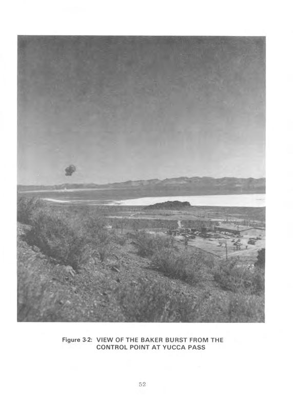
54 CHAPTER 3 SHOT BAKER Shot BAKER, the second detonation of Operation TUMBLER- SNAPPER, was conducted as scheduled at 0930 hours Pacific Standard Time on 15 April Developed by the Los Alamos Scientific Laboratory and the Department of Defense, the BAKER device was dropped from a B-50 aircraft flying over Area 7 of Yucca Flat,* UTM coordinates , at an altitude of 22,600 feet. Primarily a weapons effects test, BAKER was detonated at a height of 1,109 feet and had a yield of one kiloton (3; 4; 52; 57; 62). Figure 3-1 shows the ground zero target for BAKER; this target was also used for Shots CHARLIE and DOG. Figure 3-2 shows the BAKER detonation as seen from the Control Point at Yucca Pass. The top of the Shot BAKER cloud reached an altitude of 15,700 feet, where the winds were from the northwest at about 16 knots, and moved southeast from the point of detonation (62). The data obtained from BAKER were compared with the height of burst and blast pressure data obtained from Shot ABLE and from the BAKER burst of Operation BUSTER-JANGLE (105). 3.1 EXERCISE DESERT ROCK IV OPERATIONS AT SHOT BAKER The Desert Rock Exercise Director asked that 300 Camp Desert Rock personnel be allowed to observe Shot BAKER. However, the Test Director refused this request, and only ten individuals from the Exercise Director's immediate staff witnessed the shot, probably from near the Control Point (23). *Yucca Flat is approximately 4,000 feet above mean sea level. 50
55
56
57 3.2 DEPARTMENT OF DEFENSE PARTICIPATION IN SCIENTIFIC AND SUPPORT ACTIVITIES AT SHOT BAKER Department of Defense personnel took part in scientific and diagnostic experiments conducted by the Military Effects Test Group and the Weapons Development Test Group. Table 3-l lists the test group projects and participating agencies. In addition to the test group experiments, DOD personnel were involved in AFSWC air support activities Military Effects Test Group Projects Because Shot BAKER was detonated primarily to measure blast overpressures produced by an airdropped nuclear device, many of the Military Effects Test Group projects conducted at the shot were part of Program 1, Blast Measurements. To document the blast overpressures produced, project personnel spent several weeks before the detonation placing and calibrating pressure gauges. They completed these activities several days before the detonation. Figure 3-3 shows the instrument layouts for the Military Effects Test Group activities (10; 13-16; 98; 105). The following project descriptions often discuss recovery operations as occurring after recovery hour. The actual time of recovery hour is not known, although it probably was declared shortly after the completion of the initial radiological survey, about an hour after the shot. Project 1.2, Air Pressure versus Time, was conducted by the Stanford Research Institute to collect data on the airblast produced by an airdropped nuclear device. At 2130 hours on the night before the detonation, four personnel spent up to eight hours checking.blast gauges placed along the blast line from ground zero to 2,750 meters from ground zero. One hour after the area was opened for recovery operations, four personnel began collecting data from blast gauges positioned 2,290 and 1,140 53
58 Table 3-1: TEST GROUP ACTIVITIES WITH DEPARTMENT OF DEFENSE PARTICIPATION, SHOT BAKER Project/ rogram Title Participants Military Effects Test Group and 1.5 Air Pressure versus Time Free-air and Ground-level Pressure Measurements Stanford Research Institute Naval Ordnance Laboratory 1.4 Air Blast Measurements 1.6 Ground Acceleration Measurements 1.7 Earth Acceleration versus Time 1.9 Pm-shock Dust 1.13 Measurement of Air Blast Pressure versus Time 2.1 Total Gamma Exposure versus Distance 3.1 Vulnerability of Parked Aircraft to Atomic Bombs 3.3 Blast Damage to Trees - Isolated Conifers 3.4 Minefield Clearance Ballistic Research Laboratories Ballistic Research Laboratories Stanford Research Institute Army Chemical Center David Taylor Model Basin Signal Corps Engineering Laboratories Wright Air Development Center; Los Alamos Scientific Laboratory; Naval Radiological Defense Laboratory Forest Service, Department of Agriculture Engineer Research and Development Laboratories 6.1 Evaluation of Military Radiic Equipment Bureau of Ships; Signal Corps Engineering Laboratories 6.4 Operational Tests of Radar and Photographic Techniques for IBDA Wright Air Development Center; Strategic Air Command 7.lb Long Range Light Measurements Detection of Airborne Low-frequency Sound from Atomic Explosions Radiochemical and Physical Analysis of Atomic Bomb Debris Seismic Waves from A-Bombs Detonated over a Desert Valley Air Temperatures in the Vicinity of a Nuclear Detonation EGBG; Headquarters, Air Force Headquarters, Air Force; Signal Corps Engineering Laboratories; National Bureau of Standards Headquarters, Air Force Air Force 1699th Special Weapons Squadron; Coast and Geodetic Survey Naval Radiological Defense Laboratory 8.3 Thermal Radiation from a Nuclear Detonation Naval Radiological Defense Laboratory 54
59 Table 3-1: TEST GROUP ACTIVITIES WITH DEPARTMENT OF DEFENSE PARTICIPATION, SHOT BAKER (Continued) Project/ Program Title Participants Military Effects Test Group (Continuedj 8.4 Atmospheric Transmission and Weather Measurements Naval Material Laboratory 8.6 Sound Velocity Changes near the Ground in the Vicinity of an Atomic Explosion Naval Electronics Laboratory 9.1 Technical and Training Photography Naval Medical Research Institute; Air Force Lookout Mountain Laboratory; Wright Air Development Center; 4925th Test Group (Atomic); SAC 5th and 28th Reconnaissance Technical Squadrons; Signal Corps Engineering Laboratories; Army Pictorial Service Division 9.2 Air Weather Service Participation Air Weather Service 9.4 Effects of Atomic Explosions on the Ionosphere Signal Corps Engineering Laboratories; 8471 st Technical Service Unit 9.5 Electromagnetic Radiation over the Radio Spectrum Signal Corps Engineering Laboratories; from Nuclear Detonations 8467th Technical Service Unit.H Weapons Development Test Group 10.1 Measurement of Alpha Naval Research Laboratory 11.1 Measurement of Transit Time Naval Research Laboratory 12.1 Technical Photography EGBG 12.lc Ehangmeter Mod II EG&G 12.2a-d High-speed Photography EGbG; Los Alamos Scientific Laboratory 13 Radiochemistry Sampling Program 4925th Test Group (Atomic) 15.2 Gamma Radiation Exposure as a Function of Distance Los Alamos Scientific Laboratory 18.1 Total Thermal Radiation and Atmospheric Naval Research Laboratory Transmission 18.3 Color Temperatures Naval Research Laboratory 18.4 High-resolution Spectroscopy Naval Research Laboratory ls.la Air Shock Pressure - Time versus Distance Sandia Corporation: Los Alamos Scientific Laboratory; Armed Forces Special Weapons Project; Stanford Research Institute; Naval Ordnance Laboratory; Ballistic Research Laboratories 19.lc-d Shock-gauge Evaluations Tests Sandia Laboratory; Los Alamos Scientific Laboratory ls.le Air Shock Pressures as Affected by Hills and Dales Sandia Corporation 19.2a-b Blast-wave Material Velocity Measurements Los Alamos Scientific Laboratory; EGBG 19.2c Beta-densitometer Feasibility Test Los Alamos Scientific Laboratory 19.2d Interferometer-gauge Pressure-time Measurements Los Alamos Scientific Laboratory 19.2f Measurement of Preshock Sound Velocity Los Alamos Scientific Laboratory 55
60 Program 3 Aircraft Areas I I I I I I- Biomedical Line I Program 8 I- Blast and Thermal Line Program 3 Forest Service Line 0 I,: Kilometer 3 Figure 3-3: GROUND ZERO AND AFSWP INSTRUMENT FOR SHOTS BAKER, CHARLIE, AND DOG LAYOUTS
61 meters from ground zero. This operation took two hours. Beginning at 0900 hours on the day after the detonation, about ten project participants retrieved the remaining gauges up to the 0.1 R/h line. They spent approximately six hours in the shot area (95; 102). Projects 1.3 and 1.5, Free-air and Ground-level Pressure Measurements, were conducted as one project by the Naval Ordnance Laboratory. The objective was to measure pressures produced by a nuclear detonation at ground level and in free air (20). Five hours before the detonation, four Project 1.3 personnel spent about one hour preparing pressure gauges located between ground zero and a point 3,660 meters from ground zero. Data from the gauges were telemetered to a recording trailer about 3,660 meters from ground zero. At recovery hour, two participants began retrieving pressure data from the trailer. Their estimated working time was 30 minutes. Three hours after recovery hour, two personnel started retrieving blast gauges 3,660 meters from ground zero and continued to the 0.1 R/h line. They spent about two hours in this procedure. Beginning at 0900 hours on the day after the shot, two personnel began to inspect the blast gauges, an operation that took two hours (20; 95). Project 1.5 measured pressures in free air by photographing smoke rocket trails. At 1630 hours on the day before the shot, six personnel spent about two hours loading rocket launchers 180 to 1,070 meters north of ground zero. Seconds before the shot, the smoke rockets were launched remotely, and, immediately after the detonation, their trails were photographed. Twenty minutes after the shot, two personnel accompanied by a radiological survey team inspected and unloaded unfired rockets 920 and 1,070 meters from ground zero. Three hours after recovery operations began, six participants replaced damaged rocket launchers 180 to 920 meters from ground zero (20; 95). 57
62 Project 1.4, Air Blast Measurements, was conducted by the Ballistic Research Laboratories. The objective was to determine the shape of the pressure pulse and the peak pressure of the shock wave generated near the ground by a nuclear device detonated high in the air. Before the detonation, personnel installed instruments on lo- and 50-foot towers located about 110 and 230 meters from ground zero and then left the area. Three hours after recovery hour was declared, three project personnel began retrieving data from the stations for laboratory analysis. They spent 20 minutes in recovery operations (21; 95). Project 1.6, Ground Acceleration Measurements, was conducted by the Ballistic Research Laboratories to obtain ground acceleration measurements from an airburst nuclear detonation. Personnel measured ground shock with accelerometers positioned,before the detonation at stations 40, 190, 420, 880, and 1,330 meters from ground zero (60). At 1530 hours on the day before the shot, three project participants went to the stations to make a final instrument check. At 0900 hours on the day after the detonation, four personnel began recovering the accelerometers. Recovery took about two hours and 30 minutes (60; 95). Project 1.7, Earth Acceleration versus Time, was conducted by the Stanford Research Institute to measure the proportion of blast energy absorbed from the air by the earth. At 2130 hours on the night before the detonation, four personnel spent about eight hours checking accelerometers along the instrument line from ground zero to 2,750 meters from ground zero. One hour after the area was opened for recovery operations, four personnel began collecting data from accelerometers 2,290 and 1,140 meters from ground zero. This operation took up to two hours. Beginning at 0900 hours on the day after the detonation, about ten participants retrieved the remaining accelerometers up to the 0.1 R/h area, spending about six hours in the shot area (95; 103). 58
63 Project 1.9, Pre-shock Dust, was conducted by the Chemical and Radiological Laboratories of the Army Chemical Center. The objective was to determine the concentration and the size distribution of the dust generated before the arrival of the shock wave by thermal radiation resulting from a nuclear detonation. The day before the detonation, project personnel inspected instruments for collecting dust particles at six stations: two were located 190 meters, two others 420 meters, and two additional stations 880 meters from ground zero. The instruments, which included cascade impactors and filter samplers, collected pre-shock dust particles generated during the brief interval between the detonation and the arrival of the shock wave at each of the stations (27). After recovery hour, two project personnel and a monitor spent one hour retrieving instruments from the stations. Project personnel then took dust particle samples to the Yucca Flat airstrip where each sample was packaged, placed aboard a courier aircraft, and transported for analysis to the Army Chemical Center. Section 3.2.3, which describes AFSWC activities, discusses the courier flights (27; 95). Project 1.13, Measurement of Air Blast Pressure versus Time, was conducted by the David Taylor Model Basin. The project was designed to provide blast pressure data for Program 3 agencies, particularly those participating in Project 3.1, discussed later in this section. Before the shot, personnel calibrated and installed gauges at 16 Project 3.1 stations located 880, 1,190, and 2,400 meters from ground zero. Beginning at 2130 hours the night before the shot, four men made a final check of the gauges and left the shot area about six hours before shot-time (46). After recovery hour was announced, seven participants accompanied by a monitor spent up to two hours and 30 minutes retrieving the gauges. Five other project participants and a 59
64 radiological safety monitor spent about two hours collecting film from cameras positioned in the shot area (46; 95). Project 2.1, Total' Gamma Exposure versus Distance, was conducted by the Signal Corps Engineering Laboratories to measure gamma radiation exposure as a function of distance. Within 24 hours before the detonation, personnel placed film packets at go-meter intervals along a radial line extending up to 1,000 meters from the point of detonation. When the area was opened for recovery operations, two personnel accompanied by a monitor drove by truck into the shot area and spent about one hour retrieving the film packets. Film readings were shared with Projects 1.13, 3.1, and 6.1; the Office, Chief of Army Field Forces; and the Marine Corps (81; 95). Project 3.1, Vulnerability of Parked Aircraft to Atomic Bombs, was performed by the Wright Air Development Center and by project personnel from LASL and the Naval Radiological Defense Laboratory. The experiment was coordinated with Project 1.13, which provided airblast pressure data. The objective was to determine the effects of an airburst nuclear detonation on parked aircraft (104). Before the shot, project personnel placed aircraft at the following locations: 0 Four aircraft 720 meters north-northwest of ground zero One aircraft 1,320 meters southeast of ground zero 0 12 aircraft 2,430 meters southwest of ground zero Eight aircraft 3,190 meters southwest of ground zero. To compare the protection afforded by various defense structures, some of the aircraft were placed in revetments and behind walls, while others were positioned in the open. Personnel instrumented the aircraft with devices to measure blast, thermal, and radiation effects. 60
65 At about 0930 hours on the day before the detonation, two project personnel in a van began photographing the aircraft in the shot area and loading and aligning remote-controlled cameras. They left the area by 1430 hours. At that time, four project participants in a van began inspecting the aircraft, an activity that took about six hours (95; 104). At 1730 hours on the night before the shot, two project personnel began checking instruments in the field, a process that took about two hours. On shot-day, two individuals in a jeep made a final check of the instruments and then left the area four hours before shot-time (95; 104). When recovery hour was declared, three project personnel and a monitor began retrieving film 720 meters from ground zero, a procedure that took about three hours. Another five participants with a radiological safety monitor spent four hours recovering film 1,320 and 2,430 meters from ground zero. Three other project participants and a monitor spent about four hours collecting film 3,190 meters from ground zero (95; 104). One hour after the announcement of recovery hour, two five- man parties began inspecting the aircraft, a process that took about four hours. At 0800 hours on the day after the shot, three two-man parties began examining instruments at the aircraft stations. They spent approximately eight hours performing this task (95; 104). Project 3.3, Blast Damage to Trees--Isolated Conifers, was conducted by the Forest Service, Department of Agriculture. The experiment was designed to measure motion and strain on isolated coniferous trees subjected to a nuclear detonation. Before the shot, personnel placed four conifers, along with instruments to measure strain on the trees, at each of four stations on the Forest Service Line in Area 7. The stations were 1,520, 1,830, 61
66 2,130, and 2,440 meters from ground zero. The trees, approximately 50 feet high, were anchored in concrete. At 2130 hours on the night before the detonation, personnel entered the shot area to begin checking instruments at the stations, a procedure that took about one hour (30; 95). At the declaration of recovery hour, five project personnel entered the shot area in a weapons carrier and spent about 30 minutes inspecting the trees and recovering the instruments from the station 1,520 meters from ground zero. One hour after recovery operations began, two Project 9.1 photographers from Lookout Mountain Laboratory traveled to the Forest Service line to photograph the stations 1,520 and 1,830 meters from ground zero. They also extinguished any fires in the area. Seven hours after the announcement of recovery hour, four project personnel entered the shot area in a weapons carrier and spent about two hours inspecting the trees (30; 95). Project 3.4, Minefield Clearance, was performed by the Engineer Research and Development Laboratories. The objective was to study the detonation of land mines by a nuclear blast. Before Shot BAKER, personnel placed mines in an area 15 meters wide, which extended approximately 90 to 1,830 meters from ground zero (101). At 0800 hours on the day after the detonation, four personnel in a weapons carrier recovered mines along the blast line up to the 0.1 R/h area and determined which mines had been detonated. At the same time, they laid other mines to be used in this experiment at Shot CHARLIE. These operations took about eight hours. A representative of the Director, Military Effects Group, and three photographers took pictures of these activities (95; 101). 62
67 Project 6.1, Evaluation of Military Radiac Equipment, was conducted by the Bureau of Ships and the Signal Corps Engineering Laboratories to evaluate radiac survey equipment. Project 6.1 participants furnished standard and experimental radiation survey meters to other projects in order to evaluate the meters (107). Project 6.4, Operational Tests of Radar and Photographic Techniques for IBDA, was conducted by the Wright Air Development Center, assisted by the Strategic Air Command. The objective was to evaluate the Indirect Bomb Damage Assessment system under development at the Wright Air Development Center. The 509th Bombardment Group of SAC provided three B-50D aircraft to make a postshot test of the IBDA system. The aircraft staged from Kirtland AFB (26). Aircraft 1 and 2, simulating drop aircraft flying at an altitude of 22,600 feet, flew 1,800 and 1,300 feet, respectively, above the drop aircraft. Two seconds before release of the weapon, aircraft 1 made a 40-degree turn to the right, and air- craft 2 made a 30-degree turn to the left. The headings were held until eight seconds after shot-time. Aircraft 3, simulating an escort aircraft, was 800 feet above and five nautical miles behind the drop aircraft. Aircraft 3 held the same heading for approximately 45 seconds after shot-time and then turned to leave the area (26; 57). Project 7.lb, Long Range Light Measurements, was conducted entirely offsite by Edgerton, Germeshausen, and Grier, Inc., and Headquarters, Air Force. The objective was to gain information on the long-range detection of light produced by a nuclear detonation. EG&G and the Air Force established light-detecting stations in Arizona, Idaho, Texas, and Washington. An estimated two EG8G employees and ten Air Force personnel from the Sacramento Air Materiel Area, McClellan AFB, operated each station from about six hours before to one hour after the detonation (55). 63
68 Project 7.2, Detection of Airborne Low-frequency Sound from Atomic Explosions, was conducted by Headquarters, Air Force, with assistance from the Signal Corps Engineering Laboratories and the National Bureau of Standards. The objective was to determine the accuracy of long-range acoustic detection methods. The Signal Corps Engineering Laboratories operated stations in Alaska, Hawaii, Kentucky, New Jersey, Texas, and Washington, while the National Bureau of Standards operated its station in Washington, D.C. (97). Project 7.3, Radiochemical and Physical Analysis of Atomic Bomb Debris, was conducted by Headquarters, Air Force. The project, which involved analysis of particulate and gaseous samples from the Shot BAKER cloud, was conducted in conjunction with Program 13, Radiochemistry Sampling. Cloud sampling, performed by the 4925th Test Group (Atomic) of Kirtland AFB, is discussed in section 3.2.3, on AFSWC participation at BAKER (57; 106). Project 7.4, Seismic Waves from A-Bombs Detonated over a Desert Valley, was conducted by the Air Force 1009th Special Weapons Squadron and the Coast and Geodetic Survey. The objective was to determine the seismic properties of the geological structure of the test area. One unmanned station was located onsite, almost ten kilometers north-northwest of ground zero. No recovery operations were necessary to obtain the seismic records. The data were probably recorded at the Control Point (105). Project 8.2, Air Temperatures in the Vicinity of a Nuclear Detonation, was conducted by the Naval Radiological Defense Laboratory to determine the air temperature at various elevations and distances from ground zero. Before the shot, participants installed thermocouples at ground level and on steel towers of various heights. The towers were located at ground zero and at distances up to 1,260 meters from ground zero. At 1730 hours on 64
69 the day before the detonation, two participants checked thermocouples used to measure temperatures in the shot area. At 2130 hours on the night before the shot, six personnel spent abut two hours making final adjustments to the thermal instruments (28). When the shot area was opened for recovery operations, two crews, each consisting of three project personnel and a monitor, traveled to the instrument shelters to inspect and repair damage. They spent approximately six hours in this activity. Their forward limit was either 1,830 meters from ground zero or the 0.1 R/h line. At 0900 hours the next day, four personnel, accompanied by a Project 9.1 photographer, finished recovering the thermal detectors up to the 0.1 R/h line. They stayed in the area about four hours (28; 95). Project 8.3, Thermal Radiation from a Nuclear Detonation, was conducted by Project 8.2 and 8.3 personnel from the Naval Radiological Defense Laboratory. The objective was to measure the total thermal radiation and the intensity-time relationship of the radiation as a function of distance from ground zero. Before the shot, participants placed several types of instruments in five tower stations located at various intervals up to 1,370 meters from ground zero. These instruments included calorimeters and radiometers. Other personnel at Kirtland AFB installed three disk calorimeters in the B-50 drop aircraft. At 1730 hours on the day before the detonation, two personnel entered the shot area to check the instruments. At 2130 hours that evening, six participants proceeded into the area in a weapons carrier to adjust instruments at two of the stations. These personnel left the area within two hours (29). After the declaration of recovery hour, two teams, each of three project personnel and a monitor, drove by truck into the test area and spent a maximum of six hours retrieving instruments up to the 0.1 R/h line. An AFSWP representative accompanied 65
70 three Lookout Mountain Laboratory photographers into the shot area to photograph recovery operations. At 0800 hours on the day after the shot, the Lookout Mountain Laboratory personnel reentered the shot area to take more photographs. At about 0900 on the same day, four project personnel and a photographer recovered instruments remaining in the shot area up to the 0.1 R/h line. Project 8.2 and 8.3 personnel at Kirtland AFB removed the calorimeters from the B-50 drop aircraft (29; 95). Project 8.4, Atmospheric Transmission and Weather Measurements, was conducted by the Naval Material Laboratory. The project was designed to provide data on meteorological conditions for use in thermal radiation projects and to supplement informa- tion supplied by Project 9.2, Air Weather Service Participation. On the morning of shot-day, project personnel measured barometric pressure, temperature, humidity, and rainfall several times. They worked from a station at the BJY, where they received transmissions from two self-operating stations five kilometers northwest of the BJY. They returned to the Control Point before the shot. At the declaration of recovery hour, three project personnel went to the receiver station and spent about one hour collecting data (53; 95). Project 8.6, Sound Velocity Changes near the Ground in the Vicinity of an Atomic Explosion, was conducted by 18 Naval Electronics Laboratory personnel. The objective was to determine the velocity of sound at heights of 1.5, 10, and 54 feet above the ground at various distances from ground zero, in the interval between detonation and blast wave arrival. Participants installed instruments for detecting changes in the velocity of sound at ground zero and at stations 150, 310, 460,.and 610 meters from ground zero. Figure 3-4 shows participants installing the instruments. Six hours before shot-time, four participants entered the shot area to make a final check of the equipment, leaving the area about one hour later. After the 66
71
72 announcement of recovery hour, project personnel retrieved equipment 3,660 meters south of ground zero, a process that took about two hours. They recovered the remaining instruments on the following day (91; 95). Project 9.1, Technical and Training Photography, was conducted by personnel from the following agencies (57; 95): 0 Air Force Lookout Mountain Laboratory Army Pictorial Service Division Naval Medical Research Institute Signal Corps Engineering Laboratories SAC 5th Reconnaissance Technical Squadron SAC 28th Reconnaissance Technical Squadron Wright Air Development Center 4925th Test Group (Atomic). Project personnel from Lookout Mountain Laboratory photographed the detonation from five stations: two near the Control Point and three about 15 kilometers from ground zero near the Yucca Lake landing strip. Lookout Mountain Laboratory personnel also photographed Shot BAKER from a C-47 aircraft. The aircraft, which left Indian Springs AFB at about 0830 hours, was at an altitude of 10,000 feet approximately 11 kilometers south of ground zero at shot-time. Participants photographed the detonation and the resulting cloud formation until 0939 hours, when they began the return to Indian Springs AFB. They landed at about 0955 hours (57; 95). Project 9.1 personnel also took still photographs and motion pictures of various Military Effects Test Group projects, including Projects 1.3, 3.3, 8.2, and 8.3. For one unspecified project at Shot BAKER, five Lookout Mountain Laboratory photographers and a monitor began photographing a blast line at recovery hour, a procedure that took about one hour (95). 68
73 For Project 9.2, Air Weather Service Participation, Air Force personnel compiled data from various weather stations at the NPG and offsite, prepared weather maps, and briefed NPG officials on current and predicted weather conditions. Participants were from the 6th Weather Squadron (Mobile) of the 2059th Air Weather Wing, Tinker AFB, Oklahoma. These personnel were deployed as follows (78): Eight forecasters, 13 weather observers, and two equipment operators at the Control Point Weather Station near Yucca Pass Twelve airmen from the Rawinsonde Weather Observation Section at the Control Point and 11 airmen at a station in Tonopah, Nevada 0 Three airmen from the Pibal Weather Observation Section at Beatty, Caliente, Crystal Springs, Currant, and Warm Springs, Nevada, and St. George, Utah. Before SHOT BAKER, participants installed wind and humidity measuring instruments at two stations along the blast line 920 and 1,830 meters from ground zero. Two men began checking instruments at these stations at about 2130 hours on the night before the shot and checked the instruments hourly from eight to three hours before the detonation. About three hours after recovery hour, two participants began retrieving records from the two stations, a procedure that took two hours. At 0900 hours on the day after the shot, two personnel and a radiological monitor reentered the shot area and recovered instruments along the blast line, an activity that took approximately two hours (78; 95). Project 9.4, Effects of Atomic Explosions on the Ionosphere, was conducted by the Signal Corps Engineering Laboratories, with assistance from personnel of the 9471st Technical Service Unit. The objective was to obtain data on the effects of a nuclear detonation on the ionosphere and on subsequent ionospheric radiowave propagation. 69
74 Project personnel worked at transmitter and receiver stations. The only onsite station was a transmitter located 910 meters north of the Control Point. Two other transmitters were at Mather AFB, Sacramento, California. The radio receiver stations were at Navaho Ordnance Depot, Flagstaff, Arizona; White Sands Proving Ground, New Mexico; and Fort Sill, Oklahoma. In the days before the shot, project personnel rehearsed procedures for operating the transmitters and receivers. On shot-day, they operated instruments from one hour before to one hour after the detonation. Information collected at the project stations was sent for analysis to the Signal Corps Engineering Laboratories (49). Project 9.5, Electromagnetic Radiation over the Radio Spectrum from Nuclear Detonations, was conducted by the Signal Corps Engineering Laboratories, with assistance from the 9467th Technical Service Unit, Electronic Warfare Center. The objective was to determine the wave shape and the amplitude of radio frequency energy emanating from a nuclear detonation. During the shot, personnel operated two stations 16 to 24 kilometers from ground zero. In addition, participants manned one station at White Sands Proving Grounds, New Mexico, and another at the Evans Signal Laboratory in Belmar, New Jersey (31) Weapons Development Test Group Activities During Shot BAKER, the Weapons Development Test Group conducted experiments that involved a few DOD participants. These individuals were assigned either to LASL or to the Weapons Development Test Group to assist in the projects. Project 10.1, Measurement of Alpha, was conducted by the Naval Research Laboratory. At the announcement of recovery hour, four participants, accompanied by a radiological safety monitor, 70
75 entered the target area and recovered film from a station about 460 meters from ground zero. Their estimated working time was one hour. An hour later, a party of five and a monitor entered the same station to work on instruments for the remainder of the day (80; 95). Project 11.1, Measurement of Transit Time, was conducted by the Naval Research Laboratory. Project participants were not required to conduct recovery operations (80). Project 12.1, Technical Photography, was conducted by personnel from EGLG, with assistance from Navy personnel. They provided technical photography support, including dust studies, preshock turbulence studies, light absorption and mirage studies, fireball growth measurement, thermal effects studies, and other coverage required by the Weapons Development Test Group. Two days before the shot, project personnel prepared the film at the Control Point Building. The afternoon before Shot BAKER, project personnel loaded film into remote-controlled cameras located at various stations in the ground zero area. After the detonation, EG&G personnel recovered the exposed film and processed some of it in the mobile unit set up in the Control Point area. The remaining film was flown to laboratories of Consolidated Film Industries in Hollywood, California, and in the city of Fort Lee, New Jersey, for processing (64). Project 12.lc, Bhangmeter Mod II, was conducted by EGBG to evaluate and test a new bhangmeter. Project personnel installed these instruments for measuring the yield of a detonation at the Control Point and in the drop aircraft. Bhangmeter readings recorded at shot-time were analyzed after the shot (63). Project 12.2a-d, High-speed Photography, was conducted by LASL and EGIG. The objectives were to study early fireball 71
76 growth and to correlate shock arrival time with the appearance of the fireball. Project personnel mounted special cameras in a trailer at the BJY about four kilometers from ground zero and retrieved the film for analysis after the detonation (59). Program 13, Radiochemistry Sampling, involved cloud-sampling missions conducted by personnel from the 4925th Test Group (Atomic) (57). The sampling missions are discussed in section 3.2.3, which describes AFSWC activities at BAKER. Project 15.2, Gamma Radiation Exposure as a Function of Distance, was conducted by personnel from LASL. The objective was to measure gamma radiation exposure at various distances from the detonation. Project personnel placed gamma-detecting instruments in the ground at distances of 540 to 2,810 meters from ground zero. At recovery hour, four men accompanied by two monitors entered the shot area to recover the instruments (109). Project 18.1, Total Thermal Radiation and Atmospheric Transmission, was conducted by the Naval Research Laboratory to study the transmission of light and thermal radiation emitted by nuclear detonations of various yields. To measure the transmission of light, personnel placed one photoelectric brightness meter at the Control Point and another in Area 2 of the NPG. In addition, they installed a transmissometer near the BJY and a receiver at the Control Point. To obtain data on thermal radiation emissions, personnel also installed four thermopile recorder systems. Instruments were operated manually from the Control Point during the shot. Personnel shut down equipment after the detonation to analyze recorded data (84). Project 18.3, Color Temperatures, was conducted by the Naval Research Laboratory to measure the spectral characteristics of a nuclear fireball as a function of time. Measurements were taken with a high-speed spectrograph (61). 72
77 Project 18.4, High-resolution Spectroscopy, was conducted by the Naval Research Laboratory to supplement information obtained from spectroscopy measurements taken during previous nuclear weapons testing series, such as Operations GREENHOUSE and BUSTER-JANGLE. Project personnel installed a spectrograph at the Control Point, 17 kilometers from ground zero (24). Project 19.la, Air Shock Pressure--Time versus Distance, was conducted by the Sandia Corporation. Representatives of LASL, AFSWP, the Stanford Research Institute, the Naval Ordnance Laboratory, and the Ballistic Research Laboratories helped to plan this project. The objective was to obtain pressure measurements to use in determining the relationship between air shock pressure and height of burst. Personnel installed pressure gauges along the ground between 230 and 3,500 meters from ground zero. They also placed gauges on towers of various heights located 430 to 1,370 meters from ground zero. At the instant of burst, information from the gauges was telemetered to a recording station where it was monitored by project personnel (93). Projects 19.lc and 19.ld, Shock-gauge Evaluations Tests, were conducted by Sandia Laboratory. Personnel from LASL and contractors assisted in calibrating and installing instruments. The project was intended to develop and test new instruments for measuring dynamic and static pressures, wind directions, sound and wind speeds, and temperature rises resulting from a shock wave. Project personnel installed instruments at two stations, located 875 meters and 1,790 meters from ground zero. Cables connected the instruments to equipment that recorded the information (47). Project 19.le, Air Shock Pressures as Affected by Hills and Dales, was conducted by personnel from Sandia Corporation and AEC contractors. The objective was to collect more information about the influence of hills and valleys on the shock waves from 73
78 airbursts and to study the shielding effects of hills. Project personnel installed gauges to record air shock pressure in a line running up the front slope and down the back slope of a hill at six locations ranging from 4,940 to 5,840 meters from ground zero. Cables connected the gauges to recording equipment in a nearby mobile van. Sometime after the detonation, project participants recovered the records from the van (92). Projects 19.2a and 19.2b, Blast-wave Material Velocity Measurements, were conducted by LASL. An officer and six men from the Antiaircraft Artillery and Guided Missile Center, Fort Bliss, Texas, installed and maintained the 90-millimeter battery. The objective was to photograph peak overpressure phenomena associated with a nuclear burst. Smoke canisters were fired into the air from mortars and guns immediately before the burst so that air disturbances would be visible and could be photographed. Before the shot, project personnel entered the shot area to emplace the mortar units, set up two 90-millimeter gun stations 5,190 meters southwest of ground zero, and load the smoke canisters into the mortars and guns. Other personnel entered the shot area to load the cameras with film. An electronic timing device triggered the mortars and guns seconds before the shot. After the detonation, personnel reentered the area to retrieve film and to reload the guns and mortars for Shot CHARLIE (99). Project 19.2c, Beta-densitometer Feasibility Test, was conducted by personnel from LASL, assisted by Army personnel. The objective was to test two types of densitometers and to measure air density as a function of time after a shock wave. The densitometers, connected to recording equipment, were installed in the ground near the BAKER target area. They were set to start functioning upon receipt of an electronic timing signal. After the burst, project personnel entered the area to recover instruments and records (99). 74
79 Project 19.2d, Interferometer-gauge Pressure-time Measure- ment, was conducted by LASL (99). Project 19.2f, Measurement of Preshock Sound Velocity, was conducted by LASL with Air Force participation. The objective was to measure the velocity of sound in the air near the ground before the shock wave from the detonation arrived. Personnel installed oscillators and recording equipment at several stations near ground zero. After the detonation, personnel recovered the records from the instrument stations (99) Air Force Special Weapons Center Activities The Air Force Special Weapons Center provided personnel to staff the Air Operations Center, located at the Control Point. Besides airdropping the BAKER device, AFSWC conducted cloud sampling and sample courier missions for the test groups and cloud tracking and aerial radiological surveys of the terrain for the Test Manager. In addition to the AFSWC personnel, Strategic Air Command personnel witnessed the detonation. Although the SAC observers were not part of AFSWC, they were under the operational control of AFSWC while over the NPG, and are therefore discussed in this section (3-5; 57; 100). The following listing indicates the types and numbers of aircraft and the estimated numbers of personnel involved in air missions at Shot BAKER (57; 58): 75
80 TITLE TYPE OF AIRCRAFT NUMBER OF AIRCRAFT ESTIMATED NUMBER OF PERSONNEL Airdrop Mission B-50 Disaster Mission c Sampling Sampler Control Sampler B-29 T Sample Courier Service B-25 c-45 c Cloud Tracking B-25 B Aerial Surveys of Terrain c-47 L Observer Activities B Airdrop and Disaster Missions The B-50 drop aircraft left Kirtland AFB, New Mexico, at 0500 hours, which was four hours and 30 minutes before shot-time. The aircraft climbed to an altitude of 22,600 feet and entered a clockwise orbit over Yucca Flat at 0735 hours. Just before 0930 hours, the B-50, which was then flying on a straight and level course, released the BAKER device. The bomb was off-target by 50 meters. The aircraft left the shot area at 0935 hours, returning to Kirtland AFB at 1133 hours. The crew for this mission, from the 4925th Test Group (Atomic), had also dropped the ABLE device. The C-47 disaster aircraft, with a crew from the 4901st Support Wing (Atomic), left Kirtland AFB at about 0400 hours and orbited over Las Vegas while the B-50 completed its bomb drop mission. At 0935 hours, the aircraft began its return to 76
81 Kirtland AFB, arriving there at about 1230 hours (3; 4; 57; 58; 76). Cloud Sampling One B-29 and four T-33s collected particulate and gaseous samples of the Shot BAKER cloud for Project 7.3, Radiochemical and Physical Analysis of Atomic Bomb Debris, and for Program 13, Radiochemistry Sampling. An additional B-29 was scheduled for cloud sampling but aborted its mission because of a fuel leak. The B-29 sampler control aircraft conducted the sampling in place of the other B-29. The control aircraft, with an AFSWC aircrew and a LASL scientific advisor onboard, directed the operations of the other sampler aircraft. The control aircraft and two samplers (tail numbers 920 and 048) each penetrated the cloud four times. Each of the other two samplers made three penetrations of the cloud. The aircraft flew at altitudes of 11,500 to 15,000 feet. The following listing details the activities of each sampler aircraft (3; 4; 57; 58; 76): AIRCRAFT TYPE AND TAIL NUMBER TAKEOFF TIME TOTAL DOSIMETER READINGS (roentgens) LANDING TIME Sampler Control B-29 (386) T-33 (920) T-33 (951) T-33 (048) T-33 (913) Upon completion of their missions, the samplers returned to Indian Springs AFB and parked in the northeast corner of the parking area. Pilots then shut down the engines. The crew of 77
82 the B-29 left the aircraft through the rear door between the stabilizer and the wing. The crews of the T-33s opened their canopies and disembarked by stepping onto a boarding ladder attached to the side of the aircraft. The sample-removing team and radiological safety monitors used long-handled tools to take samples from the aircraft and place them in shielded containers. They also removed the bottles containing the gaseous samples. They then loaded the sample containers onto courier aircraft for delivery to laboratories for analysis (3; 4; 57; 58; 76). Courier Missions After the sampling missions had been completed, four aircraft of the 4901st Support Wing (Atomic) transported the cloud samples to various airbases for laboratory analysis. At 1230 hours, a B-25 flew from Indian Springs AFB to McClellan AFB with Project 7.3 samples. A C-47 flew from Indian Springs AFB to LASL at 1330 hours with Program 13 samples. Also at 1330 hours, a C-45 left Yucca Lake airstrip on a courier mission to LASL. At 1430 hours, a B-25 with Project 1.9 samples flew from Yucca Lake airstrip to the Army Chemical Center (3; 4; 57; 58; 76). Cloud Tracking Immediately after the detonation, one B-25 and one B-29 from Indian Springs AFB flew cloud-tracking missions over and beyond the NPG. The B-25 (tail number 099) took off at 0948 hours, tracked the cloud at heights ranging from 6,000 to 12,000 feet, and landed at 1518 hours. The B-29 (tail number 826) took off at 0945 hours, tracked the cloud at heights of 12,000 to 17,000 feet, and landed at 1430 hours (3; 4; 57; 58; 76). Aerial Surveys of Terrain After the detonation, two C-47 and one L-20 aircraft, all based at Indian Springs AFB, conducted radiological surveys of the terrain onsite and offsite. The following listing provides information on their activities (3; 4; 57; 76): 78
83 AIRCRAFT TYPE AND TAIL NUMBER DEPARTURE HEIGHT LANDING TIME (feet above TIME terrain) c-47 (308) , C-47 (386) , L-20 (464) , Observer Activities At Shot BAKER, 14 B-50 aircraft from the Strategic Air Command participated in an orientation and indoctrination exer- cise in nuclear weapons effects. On shot-day, 12 of the aircraft with SAC observers left Barksdale AFB-, Louisiana, and arrived over the NPG at 0829 hours. The other two B-50s took off from Travis AFB and arrived at the NPG at 0835 hours. The aircraft remained in a holding pattern through shot-time, so that observers could witness the detonation and subsequent cloud development. At 0935 hours, all aircraft left the test area for their bases (3-5; 11; 57; 76; 100). 3.3 RADIATION PROTECTION AT SHOT BAKER The primary purpose of the radiation protection procedures developed by the test groups and AFSWC for Shot BAKER was to keep individual exposures to ionizing radiation to a minimum, while still allowing participants to accomplish their missions. Logistics and Materiel From 15 April to 22 April 1952, which covers the 15 April detonation of Shot BAKER, the Logistics and Materiel Department of the AFSWP Radiological Safety Group issued 247 film badges to AEC and DOD participants in 17 programs and 66 projects. The 79
84 department also issued 392 sets of protective clothing and 90 radiological survey instruments (65). Monitoring Beginning with BAKER, eight radial lines of numbered wooden stakes were placed at go-meter intervals in the target area. These radial lines were centered on ground zero and were generally oriented toward the eight principal points of the compass. The ground survey teams measured radiation intensities at these locations. The initial ground survey teams reported data from about 30 to 75 minutes after the detonation. Toward the end of the survey, the team reported a maximum radiation intensity of 1.2 R/h at ground zero (65). Offsite ground monitoring teams and personnel who were to operate fixed sampling stations left for their assigned locations the day before the shot. The highest radiation intensity detected by these offsite monitors was to R/h on Nevada Route 52, approximately 25 kilometers south of Indian Springs, seven hours and 30 minutes after the detonation (65). Two C-47 and one L-20 aircraft conducted offsite aerial surveys of the terrain. None of the aircraft encountered significant radiation intensities (65). Plotting and Briefing The ground radiation monitoring teams provided survey data for the radiation isointensity plots. Plotting and Briefing personnel used these data to make the initial isointensity plot, a copy of which is shown in figure 3-5. Resurveys were conducted three hours later on shot-day and on 16, 17, and 18 April. Copies of the isointensity maps generated from these resurveys are shown in figure 3-6 (65). The labels of the maps in the source document do not always reflect the range of survey times given in the tables of intensity readings that accompany the maps. 80
85 t GZ 1.2Rih~.. \/ I I Meters w... Stake Lines.... : R/h O.lR/tl I Figure 3-5: INITIAL RADIATION ISOINTENSITY MAP FOR SHOT BAKER, 15 APRIL 1952,lOll TO 1040 HOURS 81
86 GZ 0.15 R/h,Meters I Meters 15 APRIL 1952,130O TO 1400 HOURS 16 APRIL 1952,070O HOURS. GZ R/h% / / * / \ Meters.... f.. P N 17 APRIL 1952,063O HOURS 18 APRIL 1952,060O TO 0632 HOURS Stake Lines R/h R/h Figure 3-6: SUBSEQUENT RADIATION ISOINTENSITY MAPS FOR SHOT BAKER 82
87 Dosimetry Data The AFSWP Radiological Safety Report indicates that the highest accumulated exposure for any AFSWP participant who was issued a film badge during the period 15 to 21 April 1952 was 0.14 roentgens, well below the established limit (65). 83
88 SHOT CHARLIE SYNOPSIS AEC TEST SERIES: TUMBLER-SNAPPER DOD EXERCISE: Exercise Desert Rock IV DATE/TIME: 22 April 1952, 0930 hours YIELD: 31 kilotons HEIGHT OF BURST: 3,447 feet (airdrop) DOD Objectives: Weather: Radiation Data: Participants: 1) To indoctrinate troops in the effects of a nuclear detonation on military equipment 2) To determine the psychological reactions of troops observing a detonation 3) To train troops in the tactical use of nuclear weapons and in radiological protection measures. At shot-time, the surface winds were six knots from the southwest. Winds were five knots from the west-northwest at 10,000 feet, 15 knots from the north-northwest at 20,000 feet, 29 knots from the northwest at 30,000 feet, and 22 knots from the west at 40,000 feet. The temperature was 19'C, the relative humidity was 30 percent, and the pressure was 873 millibars. About one hour after the shot, radiation intensities of 0.01 R/h were found at a radius of about one kilometer from ground zero. Exercise Desert Rock IV participants; Armed Forces Special Weapons Project; Air Force Special Weapons Center; Los Alamos Scientific Laboratory; Atomic Energy Commission; contractors. 84
89 CHAPTER 4 SHOT CHARLIE Shot CHARLIE, an airdropped nuclear device, detonated with a yield of 31 kilotons at 0930 hours on 22 April CHARLIE, the third nuclear test of Operation TUMBLER-SNAPPER, was developed by the Los Alamos Scientific Laboratory. The nuclear device was dropped from an AFSWC B-50 aircraft flying over Area 7 of Yucca Flat, UTM coordinates , at an altitude of 32,640 feet. Shot CHARLIE had the same ground zero as Shot BAKER, shown in figure 3-l. The cloud formed by the detonation reached from 31,000 to 42,000 feet, where the winds were from the westnorthwest at 15 to 30 knots. The cloud drifted southeast into Arizona (3; 4; 39; 52; 57; 62). CHARLIE was a weapons development and effects test. Thus, it was part of both the TUMBLER and SNAPPER phases of the operation. One of the objectives was to compare blast overpressure data from Shots CHARLIE, DOG, and EASY of Operation BUSTER-JANGLE with data from a blast detonated over the same terrain but at a different height of burst and with a larger yield. The over- Pressure data were also compared with the results of Shots ABLE and BAKER of Operation TUMBLER-SNAPPER (3; 4; 98; 105). Shot CHARLIE was the first nuclear event of Operation TUMBLER-SNAPPER opened on a limited scale to the news media. Through a program called Operation SCRIBE, representatives of the press participated in preshot activities, including tours of Indian Springs AFB, Camp Mercury, Camp Desert Rock, and the AEC Control Point at Yucca Pass. They witnessed the detonation from News Nob, a rocky hill located near the Control Point and more than 15 kilometers south of ground zero (3; 16). Figure 4-l shows some of the news media preparing to photograph the detonation from News Nob (4). 85
90
91 4.1 EXERCISE DESERT ROCK IV OPERATIONS AT SHOT CHARLIE At Shot CHARLIE, approximately 2,210 exercise troops and observers participated in Exercise Desert Rock IV programs. An additional 1,500 Camp Desert Rock troops provided radiological safety, transportation, communications, and control functions for the exercises in the forward areas. A total of 535 Army and Air Force personnel took part in the troop observer program. The tactical troop maneuvers engaged about 1,675 Army and Air Force personnel, the largest number of participants in any Exercise Desert Rock activity at Operation TUMBLER-SNAPPER (37; 50). Table 4-l summarizes information on the Desert Rock IV programs at Shot CHARLIE. Table 4-1: EXERCISE DESERT ROCK IV ACTIVITIES SHOT CHARLIE AT Program Participating Service Estimated DOD Personnel Observers Army 300 Air Force 235 Tactical Troop Maneuver Army Air Force 1, Participation of Camp Desert Rock Support Troops Camp Desert Rock troops provided logistical, operational, and administrative support to the exercise troops. In performing these duties, the support troops sometimes entered the forward area. 87
92 Two special staff sections of Exercise Desert Rock IV particularly involved in shot-day operations were the Radiological Safety Group and the Instructor Group. The Desert Rock Radiological Safety Group surveyed radiological conditions in the Desert Rock maneuver area after the CHARLIE detonation. AFSWP monitors supervised the Desert Rock group in this survey. In addition, a Desert Rock radiological safety team accompanied each platoon into the forward area. The Instructor Group consisted of five officers, an operations sergeant, one stenographer, and a classroom assistant. Instructors led the maneuver units through the display area to view the damage caused by the detonation and noted differences between the predicted and actual effects of the burst (75). Several other Desert Rock support elements engaged in activities at CHARLIE. Before the shot, personnel from the 369th Engineer Amphibious Support Regiment spent several days in the equipment display area placing military vehicles and ordnance at various distances from ground zero. Exercise troops inspected these displays as part of their orientation before and after the detonation (75). The 23rd and 31st Transportation Truck Companies transported military personnel to and from the forward area during rehearsals and on shot-day. At shot-time, these vehicles were parked south of the trench area, shown in figure 4-2 (69; 75). The Camp Desert Rock Signal Detachment, composed of personnel from the 314th Signal Construction Battalion and the 504th Signal Base Maintenance Company, established wire and radio communications within the forward area, as well as at Camp Desert Rock. It was planned that, after the shot, signal personnel would operate the two mobile public address systems in the display area to assist the Instructor Group in its presentations.
93 GROUND ZERO (UTM ) Note: This figure does not show the route taken by the official observer Pam/. Route of Advance - e Foot route t TROOP TRENCH AREA W Truck route OU Kilometers t 4 PARKING AREAS Figure 4-2: OBSERVER TRENCHES, DISPLAY AND PARKING AREAS, AND ROUTES OF ADVANCE FOR SERVICE OBSERVERS AND MANEUVER TROOPS AT SHOT CHARLIE 89
94 A medical detachment from the 369th Engineer Amphibious Support Regiment, augmented by Sixth Army medical personnel, provided support in the forward area and at Camp Desert Rock. A medical officer and aidmen accompanied the Control Group to the forward area and established an aid station south of the trenches in the parking area (75). Company A, 505th Military Police Battalion, provided traffic control in Camp Desert Rock and along the convoy route during rehearsals and on shot-day as part of the observer exercise (37; 75) Observer Activities Two groups of observers viewed the detonation. The service observers, approximately 300 Army and 235 Air Force personnel from various continental Army and Air Force commands and military service schools, observed Shot CHARLIE from trenches about 6,400 meters from ground zero. The other group of observers consisted of DOD officials, along with representatives of the news media and some local, state, and Federal Government officials. Their vantage point was News Nob, more than 15 kilometers south of ground zero (3; 4; 16; 37; 40; 75). Service Observers Both the Army and the Air Force observers participated in the same orientation and indoctrination activities for the event. Most observers reported for duty between 18 April and 21 April. On 19 April, the observers rehearsed their shot-day activities, proceeding into the trenches, shown in figure 4-3, and inspecting the equipment display area. From 19 April to 21 April, the Instructor Group used films and lectures to familiarize the observers with the characteristics of a nuclear detonation and the procedures to follow during a nuclear test (16; 42; 75). 90
95
96 At 0454 hours on 22 April, the observers left Camp Desert Rock by truck convoy for the trench area. They wore fatigue uniforms and boots and carried protective masks and helmets. The Army and Air Force personnel who were to participate in troop maneuvers were also in this convoy. Observers and exercise troops reached the trenches by about 0815 hours (69). From 75 minutes before to about 15 minutes after the detonation, a Desert Rock instructor briefed and instructed the observers. Ten minutes before shot-time, he directed them to enter their foxholes and trenches. Two minutes before shottime, the observers knelt in their trenches, covering their faces with their hands and leaning against the forward trench wall. They remained below ground level until after the detonation. Three seconds after the flash of light from the detonation, clearance was given for participants to stand upright to view the fireball and Shot CHARLIE cloud. Approximately 15 seconds after the flash, the blast wave reached the trench area 'and temporarily obscured vision. Observers remained in the trench area while Desert Rock monitors, supported by AFSWP radiological safety monitors, performed the initial radiological survey of the area. After this survey was completed, the Test Manager opened the shot area for personnel activities. The observers accompanied maneuver troops on their inspection of the equipment display area, discussed in section of this chapter (16; 37; 75). Official Observers The official observers were briefed before the shot concerning the scheduled events and radiological safety procedures. Some of the observers were given high-density goggles to wear while viewing the burst. Others were told to face away and to shield their eyes during the detonation. Figure 4-4 shows this group of observers rehearsing for Shot CHARLIE. These observers witnessed the shot from News Nob, more than 15 kilometers south of ground zero (3; 9; 16; 75). 92
97
98 One observer at News Nob described CHARLIE, shortly after detonation, as follows: It was possible to discern the outline of the fireball, the rocket trails and the antiaircraft smoke puffs, although the light was near blinding. It appeared the sky behind the bomb was a deep red with white rocket lines etched on it... The cloud left a white vapor trail as it rose, there was no mushroom stem as ordinarily occurs in low level bursts. This, combined with the high yield, gave an unusually clean and spectacular atomic cloud. The cloud formed its customary doughnut in which the brown oxides of nitrogen were clearly visible. The cloud retained its clear identity for perhaps five minutes. The noise hurt my ears and of course the dust carried by the blast blotted out everything beyond a yard for a minute or so. The Desert Rock Master of Ceremonies had repeatedly warned the observers of the dust storm which would follow the blast, yet many individuals were so impressed by the first sight of the fireball that they were standing with their mouths wide open. Consequently when the blast wave arrived these persons received a mouth full of dust as their second impression of the atomic detonation. Some observers stated that they could see the dust from the blast rolling towards their position (16). Thirty minutes after the detonation, or at about 1000 hours, nine official observers who were unable to participate in postshot activities took a bus from News Nob to Indian Springs AFB. At about 1045 hours, four buses of official DOD and Government observers, one bus of DOD technical consultants, and two buses of AEC technical observers left News Nob for the shot area. At about 1100 hours, the official observers were notified that a parachute drop maneuver to be held in conjunction with the troop maneuver had been advanced to 1115 hours. To make sure their activities would not conflict with the parachute drop, the observers stopped ahead of schedule and began lunch at about 1120 hours. 94
99 At approximately 1150 hours, the official observer convoy proceeded to an instrument shelter located near Mercury Highway, where the observers received a radiological safety briefing and toured the shelter. The convoy next proceeded to the Area 7 access road and to the radiological safety checkpoint. It then traveled on the Area 7 access road to the Project 3.1 statior area, where the observers inspected parked aircraft and were briefed by a project participant on the detonation's effects on the aircraft. The buses continued on the access road to the 0.01 R/h line, which was about 910 meters from ground zero. At this point, the official observer convoy turned back. At about 1300 hours, the bus convoy left the shot area for the return trip on Mercury Highway to the Control Point. Upon reaching the Control Point, the buses were checked for contamination. At about 1400 hours, the buses left the Control Point for Indian Springs AFB, which they reached at approximately 1530 hours. At 1710 and 1800 hours, C-54 aircraft left Indian Springs AFB to return official observers to their home stations (16) Tactical Troop Maneuver The following description of the troop maneuver at Shot CHARLIE has been reconstructed from Desert Rock IV planning documents, from scattered documents written after the exercise, and from information about the troop maneuver at Shot DOG, which was similar to the maneuver at CHARLIE. The objectives of the tactical maneuver at Shot CHARLIE, the first Army exercise of Desert Rock IV, were to: 0 Provide training in the tactical employment of nuclear weapons and in radiological protection measures Determine the psychological reactions of troops watching a detonation and passing through the area of the detonation shortly after shot-time 95
100 0 Determine the effects of the detonation on military equipment situated at various distances from ground zero. Two Army contractors, the Human Resources Research Office (HumRRO) and the Operations Research Office (ORO), conducted the psychological tests (25; 77; 113). Army units participating in the maneuver were (2; 40; 75): 0 2nd Battalion, 504th Airborne Infantry Regiment, 82nd Airborne Division, Fort Bragg, North Carolina Company B, 167th Infantry Regiment, 31st Infantry Division, Camp Atterbury, Indiana a Company C, 135th Infantry Regiment, 47th Infantry Division, Fort Rucker, Alabama Tank Platoon, 11th Armored Cavalry Regiment, Camp Carson, Colorado 0 Engineer Platoon, 369th Engineer Amphibious Support Regiment, Fort Worden, Washington 0 Medical Detachment, 369th Engineer Amphibious Support Regiment (augmented from Sixth Army), numerous Army posts. About 375 Air Force personnel from the 140th Fighter-Bomber Group (Provisional), consisting of elements from the 140th Fighter- Bomber Wing from Clovis AFB, New Mexico, also took part in the ground maneuver. For the exercise, the Army and Air Force units were organized into a battalion combat team (16; 25; 37; 68; 72; 75; 82). The Army planned the troop maneuver according to the following scenario. An aggressor with overwhelming forces invaded the western United States and pushed friendly forces into retreat. The aggressor then established a hypothetical line of strong defensive positions which resisted breakthrough by friendly forces using conventional weapons. To gain the offensive and penetrate enemy lines, friendly forces detonated Shot 96
101 CHARLIE. These troops then advanced to a position 6,400 meters south of ground zero. Meanwhile, a company of paratroopers was dropped behind enemy lines to sever enemy communications. The ground forces met at a location near ground zero to capture the enemy objective (42; 73; 75). Participating troops reported to Camp Desert Rock by 18 April From 19 April to 21 April, the Instructor Group briefed them on the effects of a nuclear detonation and on radiological safety procedures. On 19 April, the troops rehearsed shot-day activities, including an inspection of the equipment display area (16; 42; 75). HumRRO and OR0 began their study during the preshot orientation period. On 19 April, HumRRO and OR0 monitors tested 20 enlisted men from the 135th Infantry Regiment, 47th Infantry Division, and 19 enlisted men from the 504th Airborne Infantry Regiment, 82nd Airborne Division. They administered a polygraph test to these troops to determine their psychological responses to the maneuver in which they were to participate. On 21 April, HumRRO and OR0 personnel conducted a rifle disassembly-assembly test, with 50 soldiers from the 165th Regiment, 31st Infantry Division, and 49 from the 504th Airborne Infantry Regiment, 82nd Airborne Division, participating. The rifle test was repeated immediately after the shot to determine if the physical responses of the troops were slower after they had witnessed a nuclear detonation for the first time (25; 77; 113). At 0454 hours on 22 April, the troops, carrying rifles and wearing fatigue uniforms and steel helmets, began leaving Camp Desert Rock for the trench area. They reached the trenches in a truck convoy by about 0815 hours. Before and after shot-time, a Desert Rock instructor briefed them, as described in section of this chapter (69; 75; 95). 97
102 Troops entered their foxholes and trenches ten minutes before shot-time. Two minutes before the shot, they knelt, covering their faces with their hands and leaning against the forward trench wall. Three seconds after the detonation, the troops were cleared to stand up and view the fireball and resulting cloud (75). Following the detonation, the troops remained in the trench area, while Desert Rock monitors accompanied AFSWP radiological monitoring teams on the initial survey of the shot area. Meanwhile, in the trench area, HumRRO and OR0 monitors retested 25 of the original participants from the 165th Regiment in rifle disassembly-assembly (25; 75). At about 1030 hours, when the Test Manager announced recovery hour, the Exercise Director permitted personnel, including the observers, to advance by motor convoy to the shot area. The convoy traveled north on Mercury Highway to the BJy area, where it parked northeast of the intersection, shown in figure 4-2. The troops and observers then proceeded on foot to the equipment display areas, located between 3,200 meters and 180 meters west and southwest of ground zero. Figure 4-5 shows personnel of the 140th Fighter-Bomber Group (Provisional) marching to the equipment display areas. After viewing the displays, the troops advanced toward the paratrooper drop area northwest of ground zero. On their march, they approached as close as 160 meters to ground zero (16; 23; 75; 82). While ground troops were performing these activities, the Army paratroopers conducted their part of the maneuver. Before boarding the drop aircraft, paratroopers put on their parachutes, as shown in figure 4-6. At 1059 hours, five Tactical Air Command C-46 aircraft, carrying 150 paratroopers from the 2nd Battalion, 504th Airborne Infantry Regiment, 82nd Airborne Division, took off from Indian Springs AFB. The aircraft reached the test site 98
103
104
105 at about 1105 hours and established an orbiting pattern. The paratroopers were to start parachuting at 1115 hours into the area north-northwest of ground zero, shown in figure 4-2. Figure 4-7 shows the paratroopers awaiting the signal to jump. At 1109 hours, the $aratroopers in one C-46 began their jump, landing as far as 13 kilometers from the designated drop zone. Soon after, they notified the pilot that five paratroopers had been injured on landing. At 1120 hours, the crew of this C-46 reported to the Air Operations Center that its paratroopers had jumped prematurely, and the pilot asked the Air Operations Center to send a helicopter to assist the injured personnel. At 1141 hours, a YH-12 helicopter was dispatched from the Control Point. The YH-12 crew reported to the Air Operations Center at 1151 hours that the paratroopers' injuries were minor. An ambulance returned the injured paratroopers to Camp Desert Rock for medical attention (3-5; 57; 75). Paratroopers in the other four aircraft jumped as scheduled. By 1120, they were either in descent or just reaching the ground. Figure 4-S shows paratroopers descending over the designated drop zone. By about 1125, the aircraft left the shot area for the Yucca Lake airstrip, which they reached at 1143 hours (3-5; 57). The paratroopers who landed in the designated drop zone probably marched south to meet the maneuver troops and service observers. This completed the maneuver. The ground troops, service observers, and paratroopers walked back to the parking area near the BJY to be monitored for radiation. According to the Schedule of Events, they were to leave the parking area at approximately 1330 hours and travel in a truck convoy south on Mercury Highway, reaching Camp Desert Rock between 1500 and 1530 hours (95). After the troops returned to Camp Desert Rock on shot-day, HumRRO and OR0 monitors readministered the polygraph test to 101
106
107
108 20 soldiers from the 135th Infantry Regiment and 19 of the participants from the 504th Airborne Infantry Regiment. They also retested the troops on 23 April. By 24 April, the ground troops and the paratroopers were to have left Camp Desert Rock for their home stations (25). 4.2 DEPARTMENT OF DEFENSE PARTICIPATION IN SCIENTIFIC AND SUPPORT ACTIVITIES AT SHOT CHARLIE Department of Defense personnel took part in scientific and diagnostic projects conducted by the Military Effects Test Group and the Weapons Development Test Group. Table 4-2 lists the test group projects and identifies the participating agencies. In addition to participating in test group experiments, DOD per- sonnel were involved in AFSWC air support activities Military Effects Test Group Projects The Military Effects Test Group projects at Shot CHARLIE were primarily designed to document blast pressure. Personnel spent several weeks before the detonation placing and calibrating pressure gauges and other instruments in the shot area. These activities were completed the day before the detonation, when personnel left the target area after finishing their last-minute instrument checks and calibrations. Figure 3-3 shows the instrument layout for Military Effects Test Group activities at Shots CHARLIE, BAKER, and DOG. Recovery operations began after the announcement of recovery hour at 1030 hours. Project 1.2, Air Pressure versus Time, was conducted by the Stanford Research Institute to collect data on the airblast produced by an airdropped nuclear device. At 2130 hours on the night before the detonation, four personnel checked blast gauges placed along the blast line from ground zero to 2,750 meters from ground zero. They spent up to eight hours performing this 104
109 Table 4-2: TEST GROUP ACTIVITIES WITH DEPARTMENT OF DEFENSE PARTICIPATION, SHOT CHARLIE Project/ Program Title Participants Military Effects Test Group 1.2 Air Pressure versus Time Stanford Research Institute 1.3 and 1.5 Free-air and Ground-level Pressure Measurements Naval Ordnance Laboratory 1.6 Ground Acceleration Measurements 1.7 Earth Acceleration versus Time Ballistic Research Laboratories Stanford Research Institute 1.9 Pm-shock Dust 1.13 Measurement of Air Blast Pressure versus Time 2.1 Total Gamma Exposure versus Distance Army Chemical Center David Taylor Model Basin Signal Corps Engineering Laboratories 2.3 Neutron Flux and Energy Measurements Naval Research Laboratory 3.1 Vulnerability of Parked Aircraft to Atomic Bombs 3.3 Blast Damage to Trees - Isolated Conifers 3.4 Minefield Clearance Wright Air Development Center; Los Alamos Scientific Laboratory; Naval Radiological Defense Leboraton/ Forest Service, Department of Agriculture Engineer Research and Development Laboratories 4.2 Biomedical Exposure Equipment Naval Medical Research Institute 4.3 Biological Effectiveness of Neutron Radiation from Nuclear Weapons Naval Radiological Defense Laboratory 4.4 Gamma Depth Dose Measurement in Unit Density Material Naval Medical Research Institute 4.5 Flash Blindness Air Force School of Aviation Medicine; Air Training Command; Brooke Army Medical Center; Strategic Air Command 4.6 Time Course of Thermal Radiation as Measured by Bums in Pigs Neval Medical Research Institute; University of Rochester Atomic Energy Project 6.1 Evaluation of Military Radiac Equipment Bureau of Ships; Signal Corps Engineering Leboratories 6.4 Operational Tests of Radar and Photographic Techniques for IBDA Wright Air Development Center; Strategic Air Command 7.la Electromagnetic Effects from Atomic Explosions National Bureau of Standards; Air Force Cambridge Research Center; Air Weather Service; Geophysical Laboratory of the University of California at Los Angeles 7.1 b Long Range Light Measurements EG&G; Headquarters, Air Force 105
110 Table 4-2: TEST GROUP ACTIVITIES WITH DEPARTMENT OF DEFENSE PARTICIPATION, SHOT CHARLIE (Continued) Project/ Program Title Participants Military Effects Test Group Kontinuedl 7.2 Detection of Airborne Low-frequency Sound from Atomic Explosions 7.3 Radiochemical and Physical Analysis of Atomic Bomb Debris Headquarters, Air Force; Signal Corps Engineering Laboratories; National Bureau of Standards Headquarters, Air Force a Seismic Waves from A-Bombs Detonated over a Desert Valley Effects of Atomic Explosions on Forest Fuels Air Temperatures in the Vicinity of a Nuclear Detonation Thermal Radiation from a Nuclear Detonation Thermal Radiation Measurements Using Passive Indicators Air Force 1009th Special Weapons Squadron; Coast and Geodetic Survey Forest Service, Department of Agriculture Naval Radiological Defense Laboratory Naval Radiological Defense Laboratory Naval Material Laboratory 8.4 Atmospheric Transmission and Weather Measurements Naval Material Laboratory Incendiary Effects of Atomic Bomb Tests on Building Sections at Yucca Flat Sound Velocity Changes near the Ground in the Vicinity of an Atomic Explosion Forest Products Laboratory of the Forestry Service Naval Electronics Laboratory 9.1 Technical and Training Photography Naval Medical Research Institute; Air Force Lookout Mountain Laboratory; Wright Air Development Center; 4925th Test Group (Atomic); SAC 5th and 28th Reconnaissance Technical Squadrons; 301 st Signal Photo Company; Signal Corps Engineering Laboratories; Army Pictorial Service Division 9.2 Air Weather Service Participation 9.4 Effects of Atomic Explosions on the Ionosphere Air Weather Service Signal Corps Engineering Laboratories; 9471st Technical Service Unit 9.5 Electromagnetic Radiation over the Radio Spectrum Signal Corps Engineering Laboratories; from Nuclear Detonations 9467th Technical Service Unit Weapons Development Test Group 10.1 Measurement of Alpha Naval Research Laboratory 12.1 Technical Photography EGBG 12.lc Bhangmeter Mod II EGBG 12.2a-d High-speed Photography EGBG; Los Alamos Scientific Laboratory 106
111 Table 4-2: TEST GROUP ACTIVITIES WITH DEPARTMENT OF DEFENSE PARTICIPATION, SHOT CHARLIE (Continued) Projectl Program Title Participants Weapons Development Test Group (Continued) Radiochemistry Sampling Program Gamma Radiation Exposure as a Function of Distance 4925th Test Group (Atomic) Los Alamos Scientific Laboratory Radiation Monitoring Measurements Total Thermal Radiation and Atmospheric Transmission Los Alamos Scientific Laboratory Naval Research Laboratory 18.4 High-resolution Spectroscopy Naval Research Laboratory 19.la Air Shock Pressure - Time versus Distance Sandia Corporation; Los Alemos Scientific Laboratory; Armed Forces Special Weapons Project; Stanford Research Institute; Naval Ordnance Laboratory; Ballistic Research Laboratories 19.1 c-d Shock-gauge Evaluations Tests Sandia Laboratory; Los Alamos Scientific Laboratory 19.le Air Shock Pressures as Affected by Hills and Dales Sandia Corporation 19.2a-b Blast-wave Material Velocity Measurements Los Alamos Scientific Laboratory; EG&G 19.2c Betadensitometer Feasibility Test Los Alamos Scientific Laboratory 19.2d Interferometer-gauge Pressure-time Measurements Los Alamos Scientific Laboratory 19.2f Measurement of Preshock Sound Velocity Los Alamos Scientific Laboratory 107
112 activity. One hour after the area was opened for recovery operations, four personnel began collecting data from blast gauges up to ground zero. This operation took two hours (95; 102). Projects 1.3 and 1.5, Free-air and Ground-level Pressure Measurements, were conducted as one project by the Naval Ordnance Laboratory. The objective was to measure pressures produced by a nuclear detonation at ground level and in free air (20). Three hours before the detonation, four Project 1.3 personnel completed their check of pressure gauges placed flush with the earth's surface and left the shot area. The gauge measurements were telemetered to a recording trailer about 3,660 meters from ground zero. Three hours after the announcement of recovery hour, two participants spent about two hours retrieving data from the trailer. At 0900 hours on the day after the detonation, two personnel and a radiological safety monitor finished inspecting and retrieving gauges up to ground zero. Their estimated working time was two hours (20; 95). Project 1.5 measured pressures in free air by photographing smoke rocket trails. At 1530 hours on the day before the shot, six personnel spent about two hours loading rocket launchers in the shot area. Seconds before the shot, the smoke rockets were launched remotely, and immediately after the detonation, their trails were photographed. Twenty minutes after the shot, two Participants accompanied the radiological survey team into the target area, where they unloaded any unfired rockets 920 and 1,070 meters from ground zero. At 0900 hours on the day following the detonation, six project personnel replaced and reloaded smoke rocket launchers 150 meters to 920 meters from ground zero. The Schedule of Events lists their working time as "indefinite" (20; 95). 108
113 Project 1.6, Ground Acceleration Measurements, was conducted bv the Ballistic Research Laboratories. Project personnel measured ground shock with accelerometers positioned before the detonation at stations 60, 200, 430, 890, 1,340, 1,800, and 2,700 meters from ground zero. At 1530 hours on the day before the detonation, three project participants went to the stations to make a final instrument check. They left the area within two hours. At about 0900 hours on the day after the shot, four project personnel began recovering the accelerometers located in the stations along the blast line up to the 5.0 R/h area. They completed this activity within six hours (60; 95). Project 1.7, Earth Acceleration versus Time, was conducted by the Stanford Research Institute to measure the proportion of blast energy absorbed from the air by the earth. At 2130 hours on the night before the detonation, four personnel checked accelerometers placed along the instrument line from ground zero to 2,750 meters from ground zero. They spent up to eight hours in performing this activity. One hour after the area was opened for recovery operations, four personnel began collecting data from accelerometers positioned 2,290 and 1,150 meters from ground zero. This operation took two hours (95; 103). Project 1.9, Pre-shock Dust, was conducted by the Chemical and Radiological Laboratories of the Army Chemical Center. The objective was to determine the concentration and the size distribution of the dust generated before the arrival of the shock wave by thermal radiation resulting from a nuclear detonation. About four hours before shot-time, personnel inspected instruments for collecting dust particles at six stations: two were located 200 meters from ground zero, another two 430 meters, and two other stations 880 meters from ground zero. The instruments, which included cascade impactors and filter samplers, collected pre-shock dust particles generated during the brief period of time between the detonation and the arrival of the shock wave at each of the stations (27). 109
114 At the announcement of recovery hour, two personnel and a radiological safety monitor were scheduled to reenter the shot area and spend one hour retrieving instruments from the sampling stations. They then took the equipment and dust particle samples to the Yucca Flat airstrip where, within four hours, each sample was packaged and placed aboard a courier aircraft for transport to the Army Chemical Center for analysis (27; 95). Section 4.2.3, on AFSWC activities during CHARLIE, discusses the courier flights. Project 1.13, Measurement of Air Blast Pressure versus Time, was conducted by the David Taylor Model Basin. The pro,ject was to provide blast pressure data for Program 3 agencies, particularly those participating in Pro.ject 3.1, Vulnerability of Parked Aircraft to Atomic Bombs (46). Before the shot, personnel calibrated and installed gauges at 16 Project 3.1 stations located 670, 890, 1,180, 2,370, 2,380, 2,410, 3,110, and 3,130 meters from ground zero. Four people made a final check of the gauges beginning at 2130 hours the evening before the detonation. They left the shot area several hours before shot-time. After the announcement of recovery hour, five participants in a weapons carrier and truck spent up to two hours retrieving the gauges. Seven other participants and a radiological safety monitor spent up to two hours and 30 minutes collecting film from cameras in the shot area (46; 95). Project 2.1, Total Gamma Exposure versus Distance, was conducted by the Signal Corps Engineering Laboratories to measure gamma radiation exposure as a function of distance. Shortly before the detonation, personnel placed film packets at go-meter intervals along a radial line extending 1,070 to 2,400 meters outward from the point of detonation. About two hours after the declaration of recovery hour, four participants accompanied by a radiological safety monitor drove by truck into the area and 110
115 began retrieving film packets. They recovered the film packets farthest from ground zero and then worked their way toward ground zero. The estimated time for this task was four hours. Film readings were shared with Projects 1.13, 3.1, and 6.1; the Office, Chief of Army Field Forces; and the Marine Corps (81; 95). Project 2.3, Neutron Flux and Energy Measurements, was performed by the Naval Research Laboratory to measure neutron flux and to evaluate neutron dosimetry techniques. Before the shot, personnel placed gold and sulphur neutron detectors at stations 1,070 to 1,410 meters east of ground zero. Almost immediately after the shot, seven participants, a radiological safety monitor, and some Project 17.1 personnel entered the shot area to retrieve some of the instruments. They spent 75 minutes in the area (66; 95). Project 3.1, Vulnerability of Parked Aircraft to Atomic Bombs, was performed by the Wright Air Development Center and by project personnel from LASL and the Naval Radiological Defense Laboratory. The experiment was coordinated with Project 1.13, which provided air blast pressure data. The objective was to determine the effects of an airburst nuclear detonation on parked aircraft (104). Before the shot, project personnel placed aircraft at the following locations: 0 Two aircraft 440 meters north-northwest of ground zero a 12 aircraft 690 meters north-northwest of ground zero 0 Three aircraft 1,180 meters southwest of ground zero 0 One aircraft 1,360 meters southeast of ground zero 0 11 aircraft 2,390 meters southwest of ground zero 0 Six aircraft 3,160 meters southwest of ground zero. To compare the protection afforded by various defense structures, some of the aircraft were placed in revetments and behind walls, 111
116 while others were positioned in the open. Personnel instrumented the aircraft with devices to measure blast, thermal, and radiation effects. In addition, they installed a motion picture camera 2,390 meters from ground zero. At 1730 hours on the day preceding the detonation, two personnel began checking and adjusting instruments in the field, a process that took about two hours. Figure 4-9 shows a Project 3.1 participant adjusting instruments. At about 0530 hours on shot-day, four individuals in a jeep and a l/a-ton truck entered the shot area to remove dust from some of the instruments. They left the area about three hours before the detonation. At the declaration of recovery hour, two project personnel, eight firemen, and two radiological safety monitors in two pickup trucks extinguished fires at the airc.raft stations in the shot area. Nineteen project personnel with two radiological safety monitors spent about four hours inspecting blast effects on the aircraft. Three Lookout Mountain Laboratory photographers from Project 9.1 spent about three hours photographing the aircraft. Nine other participants and a radiological safety monitor took about three hours retrieving records from the aircraft stations. In addition, eight personnel spent four hours recovering film at the station 690 meters from ground zero, nine other personnel spent four hours retrieving film 2,390 meters from ground zero, and six others spent four hours collecting film 3,160 meters from ground zero. At about 0800 hours on the day after the shot, three inspection parties of two men each entered the shot area to inspect further the blast effects on the aircraft. This task was completed within eight hours (95; 104). Project 3.3, Blast Damage to Trees--Isolated Conifers, was conducted by the Forest Service, Department of Agriculture. The experiment was designed to measure motion and strain on isolated coniferous trees subjected to a nuclear detonation. Before the 112
117
118 shot, personnel placed four conifers, with instruments to measure strain on the trees, at each of four stations on the Forest Service Line in Area 7. The stations were 1,520, 1,820, 2,130, and 2,440 meters from ground zero. The trees, approximately 50 feet high, were anchored in concrete. At 2130 hours the day before the detonation, three project personnel entered the shot area to begin checking instruments at the stations. This procedure took about two hours. At the declaration of recovery hour, eight project personnel and three Project 9.1 photographers from Lookout Mountain Laboratory entered the shot area in a weapons carrier and spent about three hours inspecting and photographing the trees and recovering the instruments. Six hours after recovery hour, four personnel entered the shot area in a weapons carrier and spent about two hours inspecting the trees (30; 95). Project 3.4, Minefield Clearance, was performed by the Engineer Research and Development Laboratories. The study evaluated the practicality of using nuclear weapons to clear minefields. Before the shot, personnel laid a minefield 15 meters wide, which extended about 90 to 1,830 meters from ground zero. Two hours after recovery hour was declared, two project participants in a vehicle checked instruments at stations 910 and 1,830 meters from ground zero. At 0800 hours on the day after the detonation, 13 personnel and a radiological safety monitor in a weapons carrier recovered mines along the blast line and determined which mines had been detonated. At the same time, they laid other mines to be used in this experiment at Shot DOG. This operation took about eight hours (95; 101). Project 4.2, Biomedical Exposure Equipment, was conducted by the Naval Medical Research Institute to evaluate instruments designed to measure blast, thermal, and radiation effects on animals. To measure exposure to direct airblast, personnel 114
119 instrumented wood models of dogs with accelerometers and then placed them in containers fitted with pressure recorders. Before the detonation, they placed the containers 260, 340, 430, and 600 meters from ground zero. About three hours after the declaration of recovery hour, four participants and two radiological safety monitors began recovering instruments from the containers, a process that took about two hours (54). To measure thermal effects, personnel began placing swine in instrumented containers at about 0400 hours on shot-day. They positioned the containers 1,090, 1,570, and 2,400 meters from ground zero. In addition, they loaded heat-sensitive film into cameras located 1,130, 1,620, and 2,440 meters from ground zero. After the declaration of recovery hour, they retrieved the animals, instruments, and film (54). To measure radiation effects, participants placed dosimeters in mouse cages located 90, 120, 150, 180, 370, 460, 640, 820, and 1,010 meters from ground zero. They also positioned cameras 460, 640, 820, and 1,010 meters from ground zero. After the area was opened for recovery operations, personnel recovered dosimeters from the cages and film from the cameras (54; 95). Project 4.3, Biological Effectiveness of Neutron Radiation from Nuclear Weapons, was conducted by the Naval Radiological Defense Laboratory. The objective was to study the biological effects of neutron radiation on mice. At about 1900 hours the evening before the detonation, eight participants in two weapons carriers began placing approximately 30 mice in each of the mouse cages used in Project 4.2. They spent about one hour on this assignment and then left the shot area (35; 95). After the area was opened for recovery operations, eight participants and a radiological safety monitor in two weapons carriers spent about one hour retrieving the mice. To determine 115
120 the effects of neutron radiation on the mice, laboratory person- nel did a pathological examination of the animals (35; 95). Project 4.4, Gamma Depth Dose Measurement in Unit Density Material, was performed by the Naval Medical Research Institute. The objective was to improve techniques used to evaluate biological effects of radiation on living tissue, particularly the human body. To measure initial and residual gamma doses, project participants placed dosimeters in lucite spheres, approximating human tissue in density. Before the detonation, they placed six spheres on A-frames approximately 1,140 to 1,600 meters south of ground zero. After the declaration of recovery hour, seven personnel in two weapons carriers spent about one hour retrieving the spheres (36; 95). Project 4.5, Flash Blindness, was conducted by the Air Force School of Aviation Medicine. Participating in the project were personnel from the Air Training Command, SAC, and Brooke Army Medical Center. The objective was to determine to what degree the flash of a nuclear detonation impairs night vision. Two hours before the shot, 27 personnel traveled by bus to a trailer near the Control Point at Yucca Pass, approximately 15 kilometers from the intended ground zero. They witnessed the detonation from this trailer. Project procedure required participants to adapt their eyes to darkness by wearing dark goggles for 30 minutes and then by remaining in the darkened trailer for another 30 minutes before the shot (33; 38; 111). Along the side of the trailer were 12 portholes fitted with shutters for exposing the eyes of the test subjects to the nuclear flash. The shutters opened 48 milliseconds after the detonation and closed two seconds later. During the exposure, half of the test subjects wore protective goggles. After the exposure, participants were required to read lighted instruments to determine how soon after exposure a person could see well 116
121 enough to perform assigned tasks. Various instruments were used to examine the subjects' vision after exposure (33; 38; 95; 111). Project 4.6, Time Course of Thermal Radiation as Measured by Burns in Pigs, was conducted by the Naval Medical Research Insti- tute and the University of Rochester Atomic Energy Project. The Naval Medical Research Institute provided project equipment, while the Atomic Energy Project supplied the test animals and conducted the biological experiments. The project was designed to study the degree of skin burns in pigs exposed to a nuclear detonation (79). On the day before the detonation, project personnel weighed the pigs and inspected their skin for disease and injury. From five to three hours before the detonation, seven participants transported the pigs by truck to stations 1,080, 1,570, and 2,400 meters from ground zero. After anesthetizing the pigs and placing them in containers, the participants left the shot area. About two hours after the detonation, seven personnel in a truck recovered the animals and inspected the containers to determine if they had functioned properly during the blast. They then transported the pigs by truck to an AEC laboratory for evaluation of burns (79; 95). Project 6.1, Evaluation of Military Radiac Equipment, was conducted by the Bureau of Ships and the Signal Corps Engineering Laboratories to evaluate dosimeters. Before the shot, personnel placed 11 different dosimeters at ranges of 920 to 2,740 meters from ground zero. Two hours after the announcement of recovery hour, six project personnel and a radiological safety monitor in a vehicle began recovering the dosimeters, an activity taking three hours. In addition, Project 6.1 personnel furnished standard and experimental radiation survey meters to other projects in order to evaluate the meters (95; 107). 117
122 Project 6.4, Operational Tests of Radar and Photographic Techniques for IBDA, was conducted by the Wright Air Development Center, assisted by the Strategic Air Command. The objective was to evaluate the Indirect Bomb Damage Assessment system under development at the Wright Air Development Center. The 509th Bombardment Group of SAC provided three B-50D aircraft to make a postshot test of the IBDA system. The following listing presents information on flight times for the aircraft, which staged from Kirtland AFB (26): DEPARTURE LANDING AIRCRAFT TIME TIME B-50D B-50D B-50D Aircraft 1 and 2, simulating the drop aircraft, flew 1,800 and 1,300 feet, respectively, above the drop aircraft. Both aircraft made 40 degree turns, aircraft 1 to the right and aircraft 2 to the left. The headings were held until ten seconds before shot-time. Aircraft 3, simulating an escort aircraft, was 800 feet above and seven nautical miles behind the drop aircraft. Aircraft 3 held the same heading for approximately 45 seconds after shot-time and then turned to leave the area (26; 57). Project 7.la, Electromagnetic Effects from Atomic Explosions, was conducted by the National Bureau of Standards, Air Force Cambridge Research Center, Air Weather Service, and Geophysical Laboratory of the University of California at Los Angeles. The project was designed to study the electromagnetic pulses produced by a nuclear detonation. Data were evaluated as a means of determining the location of distant nuclear detonations. Onsite stations were at Frenchman and Yucca Flats, and 118
123 offsite stations were in Colorado, Florida, Georgia, Massachusetts, New Mexico, Virginia, Bermuda, Germany, and Puerto Rico. Three hours before the detonation, five project personnel entered the Yucca Lake recording station, 15 kilometers from ground zero, and remained there through shot-time (95; 96). Project 7.lb, Long-range Light Measurements, was conducted entirely offsite by Edgerton, Germeshausen, and Grier, Inc., and Headquarters, Air Force. The objective was to gain additional information on the long-range detection of light produced by a nuclear detonation. EGbG and the Air Force established light- detecting stations in Arizona, Idaho, Texas, and Washington. estimated two EG8G &mployees and ten Air Force personnel from the I 1 Sacramento Air Materiel Area, McClellan AFB, operated each station from about sixhours before to one hour after the detonation (55). An Project 7.2, Detection of Airborne Low-frequency Sound from Atomic Explosions, was conducted by Headquarters, Air Force, with assistance from the Signal Corps Engineering Laboratories and the National Bureau of Standards. The objective was to determine the accuracy of long-range acoustic detection methods. The Signal Corps Engineering Laboratories operated stations in Alaska, Hawaii, Kentucky, New Jersey, Texas, and Washington. The National Bureau of Standards operated a station in Washington, D.C. (97). Project 7.3, Radiochemical and Physical Analysis of Atomic Bomb Debris, was conducted by Headquarters, Air Force. The project, which involved analysis of particulate and gaseous samples from the Shot CHARLIE cloud, was conducted in conjunction with Program 13, Radiochemistry Sampling. Cloud sampling, performed by the 4925th Test Group (Atomic) of Kirtland AFB, is discussed in section (106). 119
124 Project 7.4, Seismic Waves from A-Bombs Detonated over a Desert Valley, was conducted by the Air Force 1009th Special Weapons Squadron and the Coast and Geodetic Survey. The objective was to determine the seismic properties of the geological structure of the test area. Four hours after the announcement of recovery hour, two project personnel and a radiological safety monitor recovered seismic records from stations 310 and 920 meters from ground zero. Recovery operations took one hour (34; 95). Project 8.1, Effects of Atomic Explosions on Forest Fuels, was performed by the Forest Service, Department of Agriculture, with assistance from Project 3.3 personnel and Project 9.1 photographers. The experiment was to determine the minimum thermal energies required to ignite common forest fuels (19). From five to three hours before the detonation, seven project personnel arranged forest fuels, such as conifer needles, hardwood leaves, grass, and rotten wood, in 71 trays placed at various distances from ground zero. Personnel from the LASL graphic arts section photographed the fuel beds both before and after the shot. In addition, the Army Pictorial Service Division, Office of the Chief Signal Officer, installed three motion picture cameras to photograph the ignition and combustion of the fuel beds. Thirty minutes after the detonation, six personnel with a radiological survey party entered the shot area to collect a moisture sample. The task took about 20 minutes (19; 95). Project 8.2, Air Temperatures in the Vicinity of a Nuclear Detonation, was conducted by the Naval Radiological Defense Laboratory to determine air temperatures at various elevations and distances from ground zero. Before the shot, participants installed thermocouples at ground level and on steel towers of various heights. The towers were located at ground zero and at 120
125 distances up to 2,740 meters from ground zero. At about 0330 hours on shot-day, project personnel left the test area. At the declaration of recovery hour, two three-man crews, including monitors, entered instrument shelters 920 and 460 meters from ground zero. The personnel spent up to six hours at the shelters recovering thermal data and unloading the thermal detectors. At 0900 hours on the day after the detonation, four project members, accompanied by a monitor and a photographer, recovered the thermal detectors. The estimated time of this recovery operation was six hours (28; 95). Project 8.3, Thermal Radiation from a Nuclear Detonation, was conducted by Project 8.2 and 8.3 personnel from the Naval Radiological Defense Laboratory. The objective was to measure the total thermal radiation and the intensity-time relationship of the radiation as a function of distance from ground zero (29). Before the shot, project participants placed several types of instruments in tower stations located at various intervals out to 6,100 meters from ground zero. Instruments included calorimeters, photonic cells, passive receiver panels, and radiometers. Other personnel at Kirtland AFB installed three disk calorimeters in the B-50 drop aircraft. On shot-day, personnel checked the instruments and left the area by 0330 hours. At recovery hour, six project personnel and a radiological safety monitor entered the shot area in a weapons carrier and spent a maximum of six hours retrieving instruments located farther than 460 meters from ground zero. At about 0900 hours on the day following the shot, four personnel and a radiological safety monitor recovered the remaining instruments along the blast line to ground zero. A photographer from Lookout Mountain Laboratory photographed recovery operations. Project 8.2 and 8.3 personnel at Kirtland AFB removed the calorimeters from the B-50 drop aircraft (29; 95). 121
126 Project 8.3a, Thermal Radiation Measurements Using Passive Indicators, was conducted by the Naval Material Laboratory. The purpose was twofold: To evaluate the field performance of passive heat-sensitive materials in measuring the total thermal radiation incident as a function of distance from ground zero a To test the indicators for their future use during Operation UPSHOT-KNOTHOLE in determining yield, temperature, and integrated thermal flux from the fireball. Before the detonation, Project 8.4 participants placed indicators 1,820 to 3,340 meters from the intended ground zero. Project 8.4 personnel probably retrieved these instruments along with their own instruments after the declaration of recovery hour (22; 95). Project 8.4, Atmospheric Transmission and Weather Measurements, was conducted by the Naval Material Laboratory. The project was designed to provide meteorological data for use in thermal radiation projects and to supplement information supplied by Project 9.2, Air Weather Service Participation. In addition, Project 8.4 participants assisted in Project 8.3a. At various times during shot-day, project personnel measured barometric pressure, temperature, humidity, and rainfall. They worked from a station at the BJY, where they received transmissions from two self-operating stations five kilometers to the northwest. They returned to the Control Point before the detonation. Two hours after recovery hour, seven personnel in a jeep went to the receiver station and began collecting data. They spent about three hours in the shot area (53; 95). Project 8.5, Incendiary Effects of Atomic Bomb Tests on Building Sections at Yucca Flat, was performed by the Forest Products Laboratory of the Forest Service. The objective was to 122
127 determine the probability of primary fires resulting in urban areas from a nuclear detonation. The types of structures tested were: 0 Cubicle room Right angle corner between walls 0 Right angle corner with cornice 0 Roof section. The items were constructed and mounted to resist demolition by the blast so that the incendiary effects of the nuclear flash could be studied. Thirty-one of these structures were installed at stations ranging 1,820 to 4,860 meters from ground zero (32). Project 9.1 personnel from Lookout Mountain Laboratory took documentary photographs of the displays before and after the detonation. At the declaration of recovery hour, three project participants in a weapons carrier started inspecting the displays, a process that took four hours (32; 95). Project 8.6, Sound Velocity Changes near the Ground in the Vicinity of an Atomic Explosion, was conducted by the Naval Electronics Laboratory. The objective was to determine the velocity of sound during the interval between detonation and shock wave arrival at heights of 1.5, 10, and 54 feet above ground and at various distances from ground zero (91). Before the detonation, project personnel installed instruments able to detect changes in sound velocity near the ground at stations 50, 430, 890, 1,340, and 1,800 meters from ground zero. Six hours before shot-time, four participants entered the shot area and made a final check of the equipment. They left the area approximately one hour later. After the announcement of recovery hour, four project personnel spent four hours retrieving instruments. Remaining instruments were recovered on the following day (91; 95). 123
128 Project 9.1, Technical and Training Photography, was conducted by personnel from the following agencies (1; 57; 95): Air Force Lookout Mountain Laboratory Army Pictorial Service Division Naval Medical Research Institute SAC 5th Reconnaissance Technical Squadron SAC 28th Reconnaissance Technical Squadron Signal Corps Engineering Laboratories Wright Air Development Center 301st Signal Photo Company 4925th Test Group (Atomic). Lookout Mountain Laboratory personnel photographed the CHARLIE shot from a C-47 aircraft. The aircraft, which left Indian Springs AFB at about 0832 hours, was at an altitude of 10,000 feet approximately 11 kilometers south of ground zero at shot-time. Participants photographed the detonation and the resulting cloud formation until 0941 hours, when they left the area and returned to Indian Springs AFB. They reached base at about 1000 hours (57). Project 9.1 personnel also took still photographs and motion pictures of various Military Effects Test Group projects, including 3.1, 3.3, and 8.1. In addition, they performed the following photography missions, which have not been associated with a specific project (95). At 0330 hours on shot-day, three participants proceeded to stations 1,530 and 1,830 meters from ground zero to make final adjustments to their cameras. Their estimated working time was three hours. Three hours before the detonation, Lookout Mountain Laboratory personnel went to three stations: one 610 meters northwest of the Control Point, one at the junction between the access road and the main road, and one at UTM coordinates (95). 124
129 One Lookout Mountain Laboratory photographer, three other project participants, and a monitor began photographing along the blast line at recovery hour. Their estimated working time was one hour. An hour after the announcement of recovery hour, eight participants began unloading cameras at locations between 1,530 and 4,880 meters from ground zero. They spent about four hours in this activity (95). Project 9.2, Air Weather Service Participation, involved Air Force personnel who compiled data from various weather stations at the NPG and offsite, prepared weather maps, and briefed NPG officials on current and predicted weather conditions. Project participants were from the 6th Weather Squadron (Mobile) of the 2059th Air Weather Wing, Tinker AFB, Oklahoma. These personnel were deployed as follows (78): 0 Eight forecasters, 13 weather observers, and two equipment operators at the Control Point Weather Station near Yucca Pass 0 Twelve airmen from the Rawinsonde Weather Observation Section at the Control Point and 11 airmen at a station in Tonopah, Nevada 0 Three airmen from the Pibal Weather Observation Section at Beatty, Caliente, Crystal Springs, Currant, and Warm Springs, Nevada, and St. George, Utah. Before Shot CHARLIE, participants installed wind and humidity measuring instruments at two stations along the blast line 920 and 1,830 meters from ground zero. Two men checked instruments at these stations at about 2130 hours the night before the shot and hourly from eight to three hours before the detonation (95). About three hours after the announcement of recovery hour, two participants and a radiological safety monitor in a pickup truck began retrieving records from the two stations, a procedure that took two hours. At 0900 hours on the day after the 125
130 detonation, two personnel reentered the shot area to complete recovery operations. This activity took approximately two hours (78; 95). Project 9.4, Effects of Atomic Explosions on the Ionosphere, was conducted by the Signal Corps Engineering Laboratories, with assistance from personnel of the 9471st Technical Service Unit. The objective was to obtain data on the effects of a nuclear detonation on ionospheric radiowave propagation. Personnel worked at transmitter and receiver stations. The only onsite facility was a transmitter at Station 9.4, 910 meters north of the Control Point. Two other transmitters were at Mather AFB, Sacramento, California. The radio receiver stations were at the Navaho Ordnance Depot, Flagstaff, Arizona; White Sands Proving Ground, New Mexico; and Fort Sill, Oklahoma (49). On the day before the shot, personnel practiced operating the transmitters and receivers. On shot-day, they operated instruments from one hour before to one hour after the detonation. All data obtained at the project stations were sent for analysis to the Signal Corps Engineering Laboratories (49; 95). Project 9.5, Electromagnetic Radiation over the Radio Spectrum from Nuclear Detonations, was conducted by the Signal Corps Engineering Laboratories, with assistance from the 9467th Technical Service Unit, Electronic Warfare Center. The project was designed to determine the wave shape and amplitude of radio frequency energy emanating from a nuclear detonation. Project personnel operated two stations 16 to 24 kilometers from ground zero through the detonation. In addition, participants manned one station at White Sands Proving Ground, New Mexico, and another at the Evans Signal Laboratory in Belmar, New Jersey (31; 95). 126
131 4.2.2 Weapons Development Test Group Activities Although most of the Weapons Development Test Group activ- ities were performed by AEC laboratories and contractors, some of the projects were conducted by DOD agencies. For example, the Naval Research Laboratory performed the experiments for Program 18, Thermal Measurements. In addition, a few DOD personnel wzre assigned to LASL or to the Weapons Development Test Group to assist in the projects listed in table 4-2. Project 10.1, Measurement of Alpha, was conducted by the Naval Research Laboratory. At the announcement of recovery hour, five participants and a radiological safety monitor began retrieving film from a station 920 meters from ground zero. They spent about one hour in the shot area. An hour later, five personnel and a monitor entered the station to work on instruments. This activity took the remainder of the day (80; 95). Project 12.1, Technical Photography, was conducted by personnel from EG&G, with assistance from Navy personnel. They provided technical photography support, including dust studies, preshock turbulence studies, light absorption and mirage studies, fireball growth measurement, thermal effects studies, and other technical coverage required by the Weapons Development Test Group. Two days before the shot, personnel prepared the film at the Control Point Building. The afternoon before Shot CHARLIE, they loaded film into remote-controlled cameras at various stations in the ground zero area. After the detonation, EGIG personnel recovered the exposed film and processed some of it in the mobile unit set up in the Control Point area. The remaining film was flown for processing to laboratories of Consolidated Film Industries in Hollywood, California, or in the city of Fort Lee, New Jersey (64). 127
132 Project 12.lc, Bhangmeter Mod II, was conducted by EGIG to evaluate and test a new bhangmeter. Personnel installed these instruments for measuring the yield of a detonation at the Control Point and in the drop aircraft. Bhangmeter readings recorded at shot-time were analyzed after the shot (63). Project 12.2a-d, High-speed Photography, was conducted by LASL and EG&G. The objectives were to study early fireball growth and obtain measurements correlating shock arrival time with the appearance of the fireball. Personnel mounted special cameras in a trailer about four kilometers from ground zero and retrieved the film for analysis after the detonation (59). Program 13, Radiochemistry Sampling, involved cloud-sampling by personnel from the 4925th Test Group (Atomic). The sampling missions are discussed in section 4.2'.3, on AFSWC activities at CHARLIE (57). Project 15.2, Gamma Radiation Exposure as a Function of Distance, was conducted by personnel from LASL. The objective was to measure gamma radiation exposure at various distances from the detonation. Personnel placed gamma-detecting instruments in the ground at locations between 430 and 3,690 meters from ground zero. One hour after recovery hour, two men and a monitor were scheduled to enter the shot area in a weapons carrier and spend one hour recovering the instruments (109). Project 15.3, Radiation Monitoring Measurements, was conducted by personnel from LASL. The objectives were to monitor gamma radiation levels from the radioactive fallout after a nuclear detonation and to test several prototype radiation monitoring instruments for use at Operation IVY, scheduled for the fall of The information on radiation levels was als0 used by the recovery parties. Participants installed recording equipment in stations located about 640 and 1,000 meters 128
133 northwest of ground zero. The recording equipment was set up to telemeter information on gamma radiation levels to the Control Point (83). Project 18.1, Total Thermal Radiation and Atmospheric Transmission, was conducted by the Naval Research Laboratory to study the transmission of light and thermal radiation emitted by nuclear detonations of various yields. To measure the transmission of light, personnel placed one photoelectric brightness meter at the Control Point and another in Area 2 of the NPG. In addition, they installed a transmissometer near the BJY and a receiver at the Control Point. To obtain data on thermal radiation emissions, personnel also installed four thermopile recorder systems. Participants manually operated the instruments from the Control Point during the shot. They shut down equipment after the detonation to analyze recorded data (84). Project 18.4, High-resolution Spectroscopy, was conducted by the Naval Research Laboratory to supplement information obtained from spectroscopy measurements taken during previous nuclear weapons testing series, such as Operations GREENHOUSE and BUSTER-JANGLE. Personnel installed a spectrograph at the Control Point, 17 kilometers from ground zero (24). Project 19.la, Air Shock Pressure--Time versus Distance, was conducted by the Sandia Corporation. Representatives of LASL, AFSWP, the Stanford Research Institute, the Naval Ordnance Laboratory, and the Ballistic Research Laboratories helped to plan this project. The objective was to obtain pressure measurements to use in determining the relationship between air shock pressure and height of burst. Personnel installed pressure gauges along the ground between 230 and 3,500 meters from ground zero. They also placed gauges on towers of various heights located 460 to 1,370 meters from ground zero. At the instant of burst, information from the gauges was telemetered to a recording station and monitored by project personnel (93). 129
134 Projects 19.lc and 19.ld, Shock-gauge Evaluations Tests, were conducted by Sandia Laboratory. Personnel from LASL and contractors assisted in calibrating and installing instruments. The project was intended to develop and test new instruments for measuring dynamic and static pressures, wind directions, sound and wind speeds, and temperature rises resulting from a shock wave. Personnel installed instruments at two stations located 885 meters and 1,800 meters from ground zero. Cables connected the instruments to equipment that recorded the information (47). Project 19.le, Air Shock Pressures as Affected by Hills and Dales, was conducted by personnel from Sandia Corporation and AEC contractors. The objective was to collect information about the influence of hills and valleys on the shock waves from airbursts and to study the shielding effects of hills. Project personnel installed gauges to record air shock pressure at six points in a line running over a hill. Cables connected the gauges to recording equipment in a nearby mobile van. Sometime after the detonation, participants went to the van to recover the records and found that the cables had been disconnected as a result of the detonation (92). Projects 19.2a and 19.2b, Blast-wave Material Velocity Measurements, were conducted by LASL. An officer and six men from the Antiaircraft Artillery and Guided Missile Center, Fort Bliss, Texas, installed and maintained a 90-millimeter battery. EGbG provided photography services. The objective was to photograph peak overpressure phenomena associated with a nuclear burst. Smoke canisters were fired into the air from mortars and guns immediately before the burst so that the air disturbance would be visible (99). Before the shot, project personnel emplaced mortar units along a blast line extending about one kilometer from ground zero and set up four 90-millimeter gun stations about 5,
135 meters southwest of ground zero. These mortars and guns were fired by an electronic timing device. During this time, EGtG personnel loaded the cameras with film. After the detonation, personnel reentered the area to load the mortars and guns for Shot DOG. EGBG personnel retrieved film from camera stations in the shot area (99). Project 19.2c, Beta-densitometer Feasibility Test, was conducted by LASL personnel assisted by Army personnel. The objective was to test two types of densitometers and to measure air density as a function of time after a shock wave. Partici- pants installed densitometers, which were connected to recording equipment, in the ground near ground zero. The equipment was set to start functioning upon receipt of an electronic timing signal. After the burst, project personnel entered the area to recover instruments and records (99). Project 19.2d, Interferometer-gauge Pressure-time Measure- ments, was conducted by LASL (99). Project 19.2f, Measurement of Preshock Sound Velocity, was conducted by LASL with Air Force participation. The objective was to measure the velocity of sound in the air near the ground before shock wave arrival. Personnel installed oscillators and recording equipment at several stations about 1,110 meters from ground zero. After the detonation, personnel recovered the records from the instrument stations (99) Air Force Special Weapons Center Activities Besides airdropping the CHARLIE device, AFSWC personnel conducted cloud sampling and sample courier missions for the test groups and cloud tracking and aerial radiological surveys of the terrain for the Test Manager. The Air Force Special Weapons Center also provided the personnel to staff the Air Operations 131
136 Center, located at the Control Point. In addition to the AFSWC participants, Strategic Air Command personnel witnessed the detonation. Although the SAC observers were not part of AFSWC, they were under the operational control of AFSWC while over the NPG and are therefore discussed in this section (3-5; 57; 58; 100). The following listing indicates the types and numbers of air- craft and the estimated numbers of personnel involved in air missions at Shot CHARLIE (57; 58): TITLE TYPE OF AIRCRAFT NUMBER OF NUMBER OF AIRCRAFT PERSONNEL Airdrop Mission B Disaster Mission c Sampling Sampler Control Sampler Sampler Sampler B B T F Sample Courier Service B c Cloud Tracking B-25 B Aerial Surveys of Terrain c-47 L Observer Activities B Airdrop and Disaster Missions The B-50 drop aircraft, with a crew from the 4925th Test Group (Atomic), left Kirtland AFB, New Mexico, at 0445 hours. Climbing to an altitude of 32,640 feet, the aircraft entered a clockwise bombing orbit over Yucca Flat. Just before 0930 hours, the B-50, flying a straight and level course, released the 132
137 CHARLIE device. The bomb was off-target by 45 meters. The aircraft left the shot area at 0941 hours, returning to Kirtland AFB at 1145 (3; 4; 57; 58; 76). The C-47 disaster aircraft, with a crew from the 4901st Support Wing (Atomic), left Kirtland AFB at about 0345 hours and orbited over Las Vegas during the NPG bomb drop mission. At 0934 hours, the aircraft began its return to Kirtland AFB, which it reached at 1250 hours (3; 4; 57; 58; 76). Cloud Sampling One B-29, three T-33s, and five F-84s collected particulate and gaseous samples of the Shot CHARLIE cloud for Project 7.3, Radiochemical and Physical Analysis of Atomic Bomb Debris, and for Program 13, Radiochemistry Sampling. A B-29 sampler control aircraft, with an AFSWC aircrew and a LASL scientific advisor on board, flew from Indian Springs AFB at 0815 hours and directed the operations of the sampler aircraft. The samplers flew at altitudes of 30,000 to 40,000 feet and penetrated the cloud up to 21 times. The following list summarizes their activities (3; 4; 57; 58; 76): 133
138 AIRCRAFT TYPE AND TAIL NUMBER TAKEOFF TIME TOTAL DOSIMETER READING (roentgens) LANDING TIME Sampler Control B-29 (285) B-29 (386) T-33 (951) T-33 (048) T-33 (920) T-33 (920, 2nd mission) F-84 (033) F-84 (051) F-84 (054) F-84 (043) F-84 (042) 0815 NR* NR NR NR *NR indicates not reported. One T-33 sampler (tail number 920) flew two sampling missions because another T-33 sampler (tail number 913) had been forced to abort upon reaching 30,000 feet because of engine and fuel pressure problems. The sampling sorties lasted two hours longer than anticipated. The aircraft remained in orbit for the maximum time allowed because of the relatively slow dissipation of the CHARLIE cloud (3; 4; 57; 58; 76). Upon completion of their mission, the samplers returned to Indian Springs AFB and parked in the northeast corner of the parking area. Pilots then shut down the engines. The crews of the B-29s left the craft through the rear door between the stabilizer and the wing. The aircrews of the T-33s and F-84s disembarked by stepping onto a boarding ladder attached to the side of the aircraft. The sample-removing team and radiological 134
139 safety monitors used long-handled tools to take samples from the aircraft and place them in shielded containers. They also removed the bottles containing the gaseous samples. They then loaded the sample containers onto courier aircraft for delivery to laboratories for analysis (3; 4; 57; 58; 76). Courier Missions After the sampling missions had been completed, two B-25 and two C-47 aircraft left Indian Springs AFB on shot-day to transport samples and filter papers to various laboratories for analysis. The 4901st Support Wing (Atomic) conducted these courier missions. Within a few hours after the detonation, a B-25 flew from Indian Springs AFB to McClellan AFB with Project 7.3 samples. Shortly after, a C-47 flew from Indian Springs AFB to LASL with Program 13 samples. At 1330 hours, a B-25 left Yucca Lake airstrip with Project 1.9 samples for the Army Chemical Center, and a C-47 left on a courier mission to LASL (3; 4; 57; 58; 76). Cloud Tracking Soon after the detonation, one B-25 and two B-29s f.rom Indian Springs AFB flew cloud-tracking missions over and beyond the Nevada Proving Ground. The B-25 (tail number 099) took off at 0948 hours, tracked the cloud at heights ranging from 8,500 to 12,000 feet, and landed at 1248 hours. One B-29 (tail number 826) left at 0945 hours, tracked the cloud at heights of 15,000 to 26,000 feet, and returned at 1505 hours. The second B-29 (tail number not recorded) left at 1230 (3; 4; 57; 58; 76). Aerial Surveys of Terrain After the detonation, two C-47 and one L-20 aircraft, all based at Indian Springs AFB, conducted radiological surveys of the onsite and offsite terrain. One C-47 (tail number 308) left 135
140 at 1300 hours, flew at heights of 100 to 1,500 feet, and landed at 1730 hours. The other C-47 (tail number 386) left at 1252 hours, conducted its survey at an altitude of 10,000 feet, and returned at 1550 hours. The L-20 (tail number 467) took off at 1120 hours, conducted its survey at heights of 100 to 500 feet, and returned at 1405 hours. The two C-47s performed similar surveys on 23 April (3; 57; 65). Observer Activities At Shot CHARLIE, 16 B-50 aircraft from the Strategic Air Command participated in an orientation and indoctrination exercise in nuclear weapons effects. On shot-day, the B-50s with SAC observers entered the Nevada Proving Ground area, possibly from Castle AFB and Travis AFB, between 0656 and 0828 hours. The aircraft remained in an orbiting patt.ern through shot-time so that the observers could witness the detonation and subsequent cloud development. Between 0934 and 0946 hours, all aircraft left the test area for their bases (3-5; 11; 57; 76; 100). 4.3 RADIATION PROTECTION AT SHOT CHARLIE The primary purpose of the radiation protection procedures developed by Exercise Desert Rock IV, the test groups, and AFSWC for Operation TUMBLER-SNAPPER was to keep individual exposure to ionizing radiation to a minimum, while still allowing participants to accomplish their missions Desert Rock Radiation Protection Activities The Desert Rock Radiological Safety Group devised plans and supplied personnel for radiological safety procedures associated with the CHARLIE observer activities and troop maneuver. The AEC supervised the Army in conducting these procedures. Film badge readings are limited for Desert Rock personnel at CHARLIE. 136
141 Orientation and Briefing From 19 April to 21 April, the Instructor Group conducted an indoctrination course for all Desert Rock participants at Shot CHARLIE (75). Dosimetry and Protective Equipment The Desert Rock Radiological Safety Group issued film badges to participants in Desert Rock IV exercises. In the indoctrination course, the instructors directed the participants to place their film badges in their left breast pocket, with the numbers of the badge facing outward from the body. Although the Desert Rock Radiological Safety Group issued the film badges, the AFSWP Radiological Safety Group processed them (12; 65; 75; 95). The instructors also explained the proper use of field protective masks, which the participants brought with them to Camp Desert Rock. The masks were to be worn if directions were given to evacuate the area (75). Monitoring After the detonation, Desert Rock monitors accompanied the AFSWP radiological monitoring teams in surveying the route of approach to the equipment display area. The monitors located the 0.01 R/h line along the route. After the monitors had surveyed the display route and AFSWP monitors had finished surveying the rest of the shot area, the Test Manager declared the area safe to enter. Desert Rock monitors then accompanied the troops and observers as they toured the equipment display area (12; 65; 75; 95). Decontamination In the parking area near the BJY, decontamination personnel brushed troops and observers with brooms to remove contaminated dust. They then surveyed the personnel with AN/PDR-TlB meters. 137
142 Those individuals whose contamination level could not be reduced to less than 0.01 R/h were ordered to the decontamination station at Yucca Pass for showering. Vehicles were also monitored and sent to the decontamination station near the Control Point if brushing could not reduce their level of contamination to less than 0.01 R/h. At the decontamination station, personnel were to shower and put on clean clothing. Monitors surveyed these personnel after they had showered to ensure that radiation intensities were less than R/h on clothing and nondetectable on the skin, as measured with AN/PDR-TlB meters (75) Joint AEC-DOD Radiation Protection Activities Information concerning Shot CHARLIE was obtained from the radiological safety report prepared by AFSWP (65). This document includes data on radiation safety equipment, onsite and offsite monitoring procedures, and isointensity maps. Logistics and Materiel During the period 22 April to 30 April 1952, which covers the 22 April detonation of Shot CHARLIE, the Logistics and Materiel Department of the AFSWP Radiological Safety Group issued film badges to approximately 125 AEC and DOD participants in test group projects. The Logistics and Materiel Department also issued 435 sets of protective clothing and 250 radiological survey instruments (65). Monitoring Shot CHARLIE was detonated over approximately the same Area 7 location as Shot BAKER. Initial ground survey monitors began recording radiation intensities at 1014 hours, 44 minutes after the detonation. They encountered low levels of residual 138
143 ground radioactivity since CHARLIE was detonated at a height of 3,447 feet. In addition to the initial survey, monitors conducted resurveys on 23 and 24 April (65). A helicopter also conducted a survey around the target area. The maximum intensity measured from the helicopter was 0.09 R/h at 1020 hours (65). From eight to 13 two-man mobile teams participated in offsite monitoring. About six hours before the detonation, they left the test area for assigned offsite locations. The levels of radioactivity found in offsite areas were barely detectable. The highest reported reading, R/h, was taken east of Lathrop Wells, approximately 50 kilometers southwest of the Control Point (65). Two C-47s conducted offsite aerial surveys. Neither air- craft encountered significant radiation intensities (65). Plotting and Briefing Ground radiation monitoring teams provided survey data for the isointensity plots. Plotting and Briefing personnel used these data to make the initial isointensity plot, a copy of which is shown in figure Resurveys were conducted later on 22 April and on 23 April. Copies of the isointensity maps generated from these surveys are shown in figure 4-11 (65). The labels of the maps in the source document do not always reflect the range of survey times given in the tables of intensity readings that accompany the maps. Decontamination The director of the Logistics and Materiel Department established a vehicle "hot park" near the Control Point 23 April. This area was set aside for vehicles not decontaminated below established levels and for vehicles parked overnight at the Control Point (65). On 139
144 Stake Lines R/h 0 5ou I I I Meters Figure 4-10: INITIAL RADIATION ISOINTENSITY MAP FOR SHOT CHARLIE, 22 APRIL 1952,1015 TO 1040 HOURS 140
145 22 APRIL 1952,153O HOURS 23 APRIL 1952,0645 TO 1045 HOURS Stake Lines R/h Figure 4-11: SUBSEQUENT RADIATION ISOINTENSITY MAPS FOR SHOT CHARLIE 141
146 Dosimetrv Data The highest accumulated exposure for any AFSWP participant who was issued a film badge during the period 22 to 30 April 1952 was 0.55 roentgens (65). 142
147 SHOT DOG SYNOPSIS AEC TEST SERIES: TUMBLER-SNAPPER DOD EXERCISE: Exercise Desert Rock IV DATE/TIME: 1 May 1952, 0830 hours YIELD: 19 kilotons HEIGHT OF BURST: 1,040 feet (airdrop) D 1OD Objectives: Weather: Radiation Data: Participants: 1) To train troops in the tactical use of nuclear weapons and in radiological protection measures 2) To determine the psychological reactions of troops participating in a nuclear exercise 3) To determine the effects of a nuclear detonation on military equipment placed at various distances from ground zero. At shot-time, the surface winds were three knots from the north-northeast. Winds were 31 knots from the west at 20,000 feet, 38 knots from the west-southwest at 30,000 feet, and 41 knots from the west at 35,000 feet. The temperature was 17OC, the relative humidity was 47 percent, and the pressure was 877 millibars. The initial radiological survey team measured intensities of 0.01 R/h at a radius of about 1.6 kilometers from ground zero. Exercise Desert Rock IV participants; Armed Forces Special Weapons Project; Air Force Special Weapons Center; Atomic Energy Commission; Los Alamos Scientific Laboratory; contractors. 143
148 CHAPTER 5 SHOT DOG Shot DOG, an airdropped yield of 19 kilotons at 0830 nuclear device, was detonated with a hours Pacific Standard Time* on 1 May This fourth nuclear test of Operation TUMBLER-SNAPPER was originally planned for 29 April but was rescheduled because of adverse weather conditions. Developed by the Los Alamos Scientific Laboratory, the nuclear device was dropped from a B-45 aircraft flying at an altitude of 23,050 feet over Area 7 of Yucca Flat, UTM coordinates Ground zero for Shot DOG, which was detonated at a height of 1,040 feet above Yucca Flat, was the same as that for Shots BAKER and CHARLIE. The bottom of the Shot DOG cloud reached an altitude of 28,000 feet, while the top extended to 44,000 feet. Winds were 41 knots from the west at 35,000 feet, and the cloud drifted east from the point of detonation (52; 57; 62). Shot DOG, like CHARLIE, was both a weapons effects and a weapons development test. Thus, it was part of both the TUMBLER and SNAPPER phases of the operation. The primary AEC objective was to compare blast pressure data obtained from Shots CHARLIE, DOG, and EASY of Operation BUSTER-JANGLE with data attained from a blast detonated at the same scaled height of burst and over the same terrain (3; 10; 98; 105). 5.1 EXERCISE DESERT ROCK IV OPERATIONS AT SHOT DOG Approximately 2,300 exercise troops and observers partic- ipated in Desert Rock IV programs at Shot DOG. Of these troops, *Pacific Daylight Time came into effect on 27 April 1952, but because many of the times for Shot DOG are reported in Pacific Standard Time, this report uses Pacific Standard Time for consistency. 144
149 350 Navy and Marine Corps personnel took part in the observer program, and about 1,950 personnel from the Marine Corps Provisional Atomic Exercise Unit participated in the tactical troop maneuver (23). In addition, Camp Desert Rock support troops provided logistical support for the Marine Corps exercise in the forward area and at Camp Desert Rock Participation of Camp Desert Rock Support Troops Camp Desert Rock troops provided logistical, operational, and administrative support to the Marine Corps exercise troops. In performing these duties, the troops sometimes entered the forward area. Members of the Desert Rock Radiological Safety Group assisted the AFSWP Radiological Safety Group in enforcing radiological safety criteria and conducting radiation surveys. Survey teams from the Marine Corps Provisional Atomic Exercise Unit participated in the postshot survey of the shot area. Each survey team consisted of one radiological safety monitor from the Marine Corps Provisional Atomic Exercise Unit, one monitor from the AFSWP Radiological Safety Group, and an unspecified number of Desert Rock monitors. A radiological safety team, consisting of two Marine Corps monitors, also accompanied each platoon into the forward area. The Instructor Group led the maneuver units through the display area to view the damage caused by the detonation and noted the differences between the predicted and actual effects (75; 88). In addition to the Instructor Group and the Radiological Safety Group, several other support elements were active at Shot DOG. Before the shot, Marines from the Marine Corps Provisional Atomic Exercise Unit spent several days preparing the equipment 145
150 display area, shown in figure 5-1. Marine Corps exercise troops would examine the preshot condition of these displays, predict the expected damage, and re-inspect these displays after the detonation (89). The 23rd and 31st Transportation Truck Companies, assigned to Camp Desert Rock, provided vehicles and drivers to transport Navy and Marine Corps personnel to and from the forward area. The vehicles were parked south of the trench area at shot-time (70; 90). Personnel from the Camp Desert Rock Signal Detachment furnished wire and sound communications facilities within the forward area, as well as at Camp Desert Rock. However, it was planned that Marine Corps signal personnel would operate the two mobile public address systems in the display area to assist with the Instructor Group's postshot presentations and with other _ communications needs (75; 89). The Marine Corps 1st and 2d Provisional Medical Clearing Platoons provided medical support in the forward area during the maneuver. One Navy medical officer was to accompany the Control Group to the forward area and remain at the forward command post throughout the maneuvers (89). Company A, 505th Military Police Battalion, provided traffic control in Camp Desert Rock and along the convoy route during rehearsals and on shot-day as part of the observer exercise (75; 89) Troop Observer Activities The Navy and Marine Corps observers took part in the same orientation and training activities for the event. Most observers reported for duty between 24 April and 28 April. On 146
151 Ground Zero (UTM ) Equipment Display - Parking \\ Il./x Area II A AREA 7 II Route of Advance _) Foot Route H-4 Truck Route 0 1 I I Kilometers I Troop Trench Area eza eza m Parking Areas Figure 5-1: OBSERVER TRENCHES, DISPLAY AND PARKING AREAS, AND ROUTES OF ADVANCE FOR EXERCISE DESERT ROCK IV ACTIVITIES AT SHOT DOG 147
152 27 April, they rehearsed their shot-day activities, including an inspection of the equipment display area. From 26 April to 29 April, the Instructor Group presented an orientation for the observers, who viewed films and attended lectures on the charac- teristics of a nuclear detonation and the procedures to follow during a detonation. When Shot DOG was postponed for 48 hours, the Instructor Group presented additional information to the observers (6; 7; 17; 70; 71; 75; 86-90). At 0400 hours on 1 May, the observers left Camp Desert Rock for the trench area. The trenches were 6,400 meters south of ground zero, at UTM coordinates After the observers arrived at the trench area at about 0630 hours, the Instructor Group conducted a preshot orientation. Ten minutes before shottime, the observers were directed to enter the trenches. About 90 minutes after the detonation, the observers began their trip by truck to the display areas shown in figure 5-l. The observers followed the same route as the maneuver troops, described in section Following their tour of the display area, they returned to Camp Desert Rock (70; 71; 75; 85-87; 89; 90) Tactical Troop Maneuver An estimated 1,950 personnel from the Marine Corps Pro- visional Atomic Exercise Unit took part in the tactical maneuver at Shot DOG. This was the first Marine Corps maneuver of the continental nuclear weapons testing series. The objectives of the maneuver, as described by the Commandant of the Marine Corps, were to (87): 0 Provide realistic training for ground units when supported by tactical atomic weapons a Provide realistic training in protective measures 148
153 0 Determine the type and amount of nuclear warfare indoctrination required for all personnel 0 Determine the psychological reactions of troops participating in the exercise. In late March 1952, at Camp Pendleton, California, the Commanding General, Department of the Pacific, and Marine Corps staff officers began planning for Marine Corps participation in Exercise Desert Rock IV. On 31 March, the officers attended a Desert Rock IV planning conference with the Exercise Director and his staff at Camp Desert Rock, Nevada. Among other decisions, the conferees decided that a Marine Corps officer would serve as liaison between the Marine Corps and the Sixth Army to coordinate Desert Rock IV exercises. During the same period, the Commanding General, Department of the Pacific, directed approximately 100 officers and enlisted men to report to Camp Pendleton, where they were organized into the Headquarters, Marine Corps Provisional Atomic Exercise Unit. This group was officially activated on 9 April 1952, to direct Marine Corps maneuvers at the Nevada Proving Ground. Also in March 1952, the Marine Corps organized two provisional composite infantry battalions to participate in the maneuvers. The two battalions, each consisting of about 950 men, were the 1st Provisional Marine Battalion of Camp Pendleton, California, and the 2d Provisional Marine Battalion of Camp Lejeune, North Carolina. At the Nevada Proving Ground, the battalions became the maneuver units of the Marine Corps Provisional Atomic Exercise Unit (41; 43-45; 56; 70; 71; 88; 89). The two battalions received instruction at their home stations concerning radiological safety procedures and the effects of a nuclear detonation. They were then airlifted to Camp Desert Rock, where the 1st Provisional Marine Battalion arrived on 23 April and the 2d Battalion on 24 April
154 On 25 April, the Marines completed modifications and equipment installations at the four display areas shown in figure 5-l. The display areas, located on approximately the same sites used at Shot CHARLIE, were west and southwest of ground zero at the following locations: 0 Display area 1, located about 270 to 370 meters from ground zero 0 Display area 2, located about 820 to 910 meters from ground zero 0 Display area 3, located about 1,550 to 1,600 meters from ground zero 0 Special display area (unnumbered), located about 1,190 meters from ground zero. On 26 April, the troops completed their orientation program, which included lectures on the maneuvers and on radiological monitoring techniques. A full rehearsal of the Marine exercise, scheduled for 26 April, was postponed until 27 April. The Marine Corps Provisional Atomic Exercise Unit developed the troop maneuver according to the following scenario. An aggressor with overwhelming forces invaded an island called Yucca (Yucca Flat in the exercise) and pushed friendly forces into retreat. The aggressor then established a line of strong defensive positions which resisted breakthrough by friendly forces. To gain the offensive and penetrate enemy lines, friendly forces detonated Shot DOG. Three Marine divisions landed on the southern end of Yucca Island and advanced to a position 6,400 meters from the two enemy divisions entrenched near the intended ground zero. After detonating DOG, friendly forces gained control of the island both on the ground and in the air. Participants in the Marine Corps exercise wore utility uniforms with boots, steel helmets, and web belts with canteens 150
155 and first aid packets. Each Marine also wore a film badge and carried a protective mask and a rifle (70; 75; 85-87; 89; 90). The Marine Corps Provisional Atomic Exercise Unit began the trip by truck convoy to the trench area at 0400 hours on 1 May The convoy reached the trenches one hour before the detonation. Figure 5-2 shows Marines assembling in the trench area before the shot (85; 90). Beginning 45 minutes before the detonation, a Desert Rock instructor briefed and instructed the troops. Ten minutes before shot-time, he directed participants to enter their trenches and foxholes, which had also been used for the troop maneuver at Shot CHARLIE. Two minutes before shot-time, the instructor told participants to crouch and to remain below ground level until after the detonation. After the flash of light from the detonation, personnel were cleared to stand and view the fireball and Shot DOG cloud. Figure 5-3 shows Marines in the trench area watching the cloud (70; 75; 85-87; 89; 90). While the troops remained at the trench area, the radiological safety party of the Marine Corps Provisional Atomic Exercise Unit accompanied AFSWP and Desert Rock monitoring teams on the initial survey of the ground zero area. After the Test Manager announced recovery hour at 0951 hours, the Marines traveled by truck to the parking area northeast of the BJY. They formed company-sized units to tour display areas 2 and 3 on foot. Because of the radiation intensity, they could not inspect display area 1, nor could they launch an attack on ground zero. Marine Corps photographers, one of whom is shown in figure 5-4, took pictures of the damage in the display area (75; 88; 89). The Marines then returned to the parking area near the BJY, where they were monitored, as shown in figure 5-5. They began 151

156
157
158
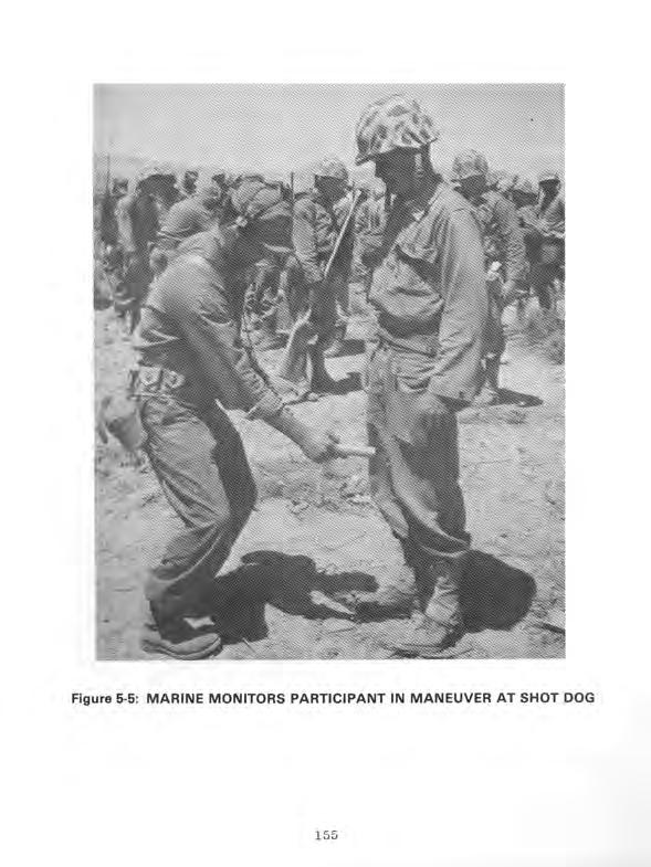
159
160 their return by truck to Camp Desert Rock at about 1350 hours. The convoy traveled south on Mercury Highway and reached Camp Desert Rock around 1530 hours. On arrival, participants were required to shower to reduce radiation intensities to background levels (71; 85; 95). The day after the detonation, Marine participants prepared to return to their home bases. By evening, all units had been transported either to Indian Springs AFB or to McCarran Field, Las Vegas, and had left for their destinations by Air Force or commercial aircraft (70; 75; 85-89). 5.2 DEPARTMENT OF DEFENSE PARTICIPATION IN SCIENTIFIC AND SUPPORT ACTIVITIES AT SHOT DOG Department of Defense personnel took part in scientific and diagnostic experiments conducted by the Military Effects Test Group and the Weapons Development Test Group. Table 5-l lists the test group experiments and identifies the participating agencies. In addition to the participants in test group experi- ments, Air Force Special Weapons Center personnel provided air support to the test groups and the Test Manager (17) Military Effects Test Group Projects Projects conducted by the Military Effects Test Group at Shot DOG were primarily designed to document blast pressures. Project participants spent several weeks before the detonation placing and calibrating pressure gauges and other instruments. These activities were completed by the day before the detonation. Figure 3-3 shows the instrument layout for Military Effects Test Group activities at Shots DOG, BAKER, and CHARLIE. Recovery operations began after the announcement of recovery hour at 0951 hours. 156
161 Table 5-1: TEST GROUP ACTIVITIES WITH DEPARTMENT OF DEFENSE PARTICIPATION, SHOT DOG Project/ Program Title Participants Military Effects Test Group and 1.5 Air Pressure versus Time Free-air and Ground-level Pressure Measurements Stanford Research Institute Naval Ordnance Laboratory 1.4 Air Blast Measurements 1.6 Ground Acceleration Measurements 1.7 Earth Acceleration versus Time 1.9 Pm-shock Dust 1.13 Measurement of Air Blast Pressure versus Time 2.1 Total Gamma Exposure versus Distance 2.3 Neutron Flux and Energy Measurements 3.1 Vulnerability of Parked Aircraft to Atomic Bombs 3.3 Blast Damage to Trees - Isolated Conifers 3.4 Minefield Clearance Ballistic Research Laboratories Ballistic Research Laboratories Stanford Research Institute Army Chemical Center David Taylor Model Basin Signal Corps Engineering Laboratories Naval Research Laboratory Wright Air Development Center; Los Alamos Scientific Laboratory; Naval Radiological Defense Laboratory Forest Service, Department of Agriculture Engineer Research and Development Laboratories Biomedical Exposure Equipment Biological Effectiveness of Neutron Radiation from Nuclear Weapons Naval Medical Research Institute Naval Radiological Defense Laboratory 4.4 Gamma Depth Dose Measurement in Unit Density Material Naval Medical Research Institute 4.5 Flash Blindness Air Force School of Aviation Medicine; Air Training Command; Brooke Army Medical Center; Strategic Air Command la Time Course of Thermal Radiation as Measured by Burns in Pigs Evaluation of Military Radiac Equipment Operational Tests of Radar and Photographic Techniques for IBDA Decontamination of Aircraft Electromagnetic Effects from Atomic Explosions Naval Medical Research Institute; University of Rochester Atomic Energy Project Bureau of Ships; Signal Corps Engineering Laboratories Wright Air Development Center; Strategic Air Command Wright Air Development Center; Naval Radiological Defense Laboratory National Bureau of Standards; Air Force Cambridge Research Center; Air Weather Service; Geophysical Laboratory of the University of California at Los Angeles 7.lb Long Range Light Measurements EG&G; Headquarters, Air Force
162 Table 51: TEST GROUP ACTIVITIES WITH DEPARTMENT OF DEFENSE PARTICIPATION, SHOT DOG (Continued) Project/ Program Title Participants Military Effects Test Group (Continued) 7.2 Detection of Airborne Low-frequency Sound from Atomic Explosions 7.3 Radiochemical and Physical Analysis of Atomic Bomb Debris Headquarters, Air Force; Signal Corps Engineering Laboratories; National Bureau of Standards Headquarters, Air Force Seismic Waves from A-Bombs Detonated over a Desert Valley Effects of Atomic Explosions on Forest Fuels Air Temperatures in the Vicinity of a Nuclear Detonation Thermal Radiation from a Nuclear Detonation Atmospheric Transmission and Weather Measurements Air Force 1809th Special Weapons Squadron; Coast and Geodetic Survey Forest Service, Department of Agriculture Naval Radiological Defense Laboratory Naval Radiological Defense Laboratory Naval Material Laboratory Incendiary Effects of Atomic Bomb Tests on Building Sections at Yucca Flat Sound Velocity Changes near the Ground in the Vicinity of an Atomic Explosion Forest Products Laboratory of the Forest Service Naval Electronics Laboratory 9.1 Technical and Training Photography Naval Medical Research Institute; Air Force Lookout Mountain LaboratorY; Wright Air Development Center; 4925th Test Group (Atomic); SAC 5th and 28th Reconnaissance Technical Squadrons; Signal Corps Engineering Laboratories; Army Pictorial Service Division 9.2 Air Weather Service Participation Air Weather Service 9.4 Effects of Atomic Explosions on the ionosphere Signal Corps Engineering Laboratories: 9471 st Technical Service Unit 9.5 Electromagnetic Radiation over the Radio Spectrum Signal Corps Engineering l&oratories; from Nuclear Detonations 9487th Technical Service Unit I Weapons Development Test Group 10.1 Measurement of Alpha Naval Research Laboratory 12.1 Technical Photography EGBG 12.lc Bhangmeter Mod ii EGbG 12.2a-d High-speed Photography EGbG; Los Alamos Scientific Laboratory
163 Table 5-1: TEST GROUP ACTIVITIES WITH DEPARTMENT OF DEFENSE PARTICIPATION, SHOT DOG (Continued) Project/ Program Title Participants Weapons Development Test Group Kontinued) and 17.2 Radiochemistry Sampling Program Gamma Radiation Exposure as a Function of Distance Radiation Monitoring Measurements External Neutron Measurements 4925th Test Group (Atomic) Los Alamos Scientific Laboratory Los Alamos Scientific Laboratory Los Alamos Scientific Laboratory 18.1 Total Thermal Radiation and Atmospheric Transmission 18.3 Color Temperatures 18.4 High-resolution Spectroscopy Naval Research Laboratory Naval Research Laboratory Naval Research Laboratory 19.la Air Shock Pressure - Time versus Distance Sandia Corporation; Los Alamos Scientific Laboratory; Armed Forces Special Weapons Project; Stanford Research Institute; Naval Ordnance Laboratory; Ballistic Research Laboratories 19.1 c-d Shock-gauge Evaluations Tests Sandia Laboratory; Los Alamos Scientific Laboratory 19.le 19.2a-b Air Shock Pressure as Affected by Hills and Dales Blast-wave Material Velocity Measurements Sandia Corporation Los Alamos Scientific Laboratory; EG&G 19.2c Betadensitometer Feasibility Test 19.2d Interferometer-gauge Pressure-time Measurements 19.2f Measurement of Preshock Sound Velocity Los Alamos Scientific Laboratory Los Alamos Scientific Laboratory Los Alamos Scientific Laboratory 159
164 Project 1.2, Air Pressure versus Time, was conducted by the Stanford Research Institute to collect data on the airblast produced by an airdropped nuclear device. At 2130 hours on the night before the detonation, four personnel checked blast gauges placed along the blast line from ground zero to 2,750 meters from ground zero. They spent up to eight hours performing this activity. One hour after the area was opened for recovery operations, four personnel began collecting data from blast gauges 2,290 and 1,140 meters from ground zero. This operation took two hours. Beginning at 0900 hours on the day after Shot DOG, about ten participants retrieved remaining gauges up to the 0.5 R/h line. They spent about six hours in the shot area (95; 102). Projects 1.3 and 1.5, Free-air and Ground-level Pressure Measurements, were conducted as one project by the Naval Ordnance Laboratory. The objective was to measure pressures produced by a nuclear detonation at ground level and in free air (20). Project 1.3 personnel installed gauges flush with the earth's surface to measure air pressure at ground level. The gauge readings were telemetered to a trailer 3,660 meters from ground zero. Three hours after the announcement of recovery hour, two two-man teams began retrieving data from the trailer and gauges up to the 0.1 R/h line. They spent about two hours in these activities (20; 95). Project 1.5 measured pressures in free air by photographing smoke rocket trails. At 1530 hours on the day before the detonation, six Project 1.5 personnel loaded rocket launchers 150 to 1,070 meters from ground zero. Their estimated working time was two hours. At shot-time, they launched the rockets remotely, and the rocket trails were photographed. Thirty minutes after the detonation, two project members accompanied the radiological 160
165 survey team into the target area. There, they disarmed and unloaded the unfired rockets at locations 920 to 1,070 meters from ground zero. At 0900 hours on the day after the detonation, six project participants removed rocket launchers, working up to the 0.5 R/h line (20; 95). Project 1.4, Air Blast Measurements, was conducted by the Ballistic Research Laboratories to determine the shape and peak pressure of the shock wave generated near the ground from a nuclear device detonated high in the air. Before the shot, personnel installed instruments on lo- and 50-foot towers at ground zero and at stations 460 and 920 meters from ground zero. Three hours after the declaration of recovery hour, personnel reentered the shot area and spent about 20 minutes collecting data from the stations for laboratory analysis (21; 95). Project 1.6, Ground Acceleration Measurements, was conducted by the Ballistic Research Laboratories to obtain secondary ground acceleration measurements. Participants measured ground shock with accelerometers positioned at stations 80, 190, 410, 870, 1,320, 1,780, and 2,690 meters from ground zero. At 1530 hours on the day before the detonation, three project participants went to the stations to make a last-minute instrument check. They left the area within two hours. At about 0900 hours on the day after the detonation, four project personnel began recovering the accelerometers located in the stations along the blast line to the 0.5 R/h line. They completed this activity within six hours (60; 95). Project 1.7, Earth Acceleration versus Time, was conducted by the Stanford Research Institute to measure the proportion of blast energy absorbed from the air by the earth. At 2130 hours on the night before the detonation, four personnel checked accelerometers placed along the instrument line from ground zero to 2,750 meters from ground zero. They spent up to eight hours in performing this activity (95; 103). 161
166 One hour after the area was opened for recovery operations, four project personnel began collecting data from accelerometers 2,290 and 1,140 meters from ground zero. This operation took two hours. Beginning at 0900 hours on the day after the detonation, about ten participants retrieved the remaining accelerometers up to the 0.5 R/h line. They spent about six hours in the shot area (95; 103). Project 1.9, Pre-shock Dust, was conducted by the Chemical and Radiological Laboratories of the Army Chemical Center. The objective was to determine the concentration and distribution of the dust generated by the action of thermal radiation on the surface of the ground (27). About four hours'before shot-time, personnel inspected instruments for collecting dust particles at seven stations: two were located 210 meters from ground zero, two located 420 meters from ground zero, and three located 870 meters from ground zero. The instruments, which included cascade impactors and filter samplers, collected pre-shock dust particles generated during the brief period of time between the detonation and the arrival of the shock wave (27; 95). Two hours after the announcement of recovery hour, two project personnel were scheduled to reenter the shot area and spend no more than one hour removing instruments from the sampling stations. They then took the equipment and dust particle samples to the Yucca Flat airstrip where, within four hours, each sample was packaged and placed aboard a courier aircraft for transport to the Army Chemical Center for analysis (27; 95). Section 5.2.3, on AFSWC activities during Shot DOG, discusses the courier flights. Project 1.13, Measurement of Air Blast Pressure versus Time, was conducted by the David Taylor Model Basin. The project was 162
167 designed to provide blast pressure data for Program 3 agencies, particularly those participating in Project 3.1, Vulnerability of Parked Aircraft to Atomic Bombs (46). Before the detonation, personnel calibrated and installed gauges at 16 Project 3.1 stations located 680 to 3,110 meters from ground zero. Four men made a final check of the gauges beginning at 2130 hours on the evening before the detonation and ending several hours before shot-time. After the announcement of recovery hour, five participants spent up to two hours retrieving the gauges. Seven other participants entered the shot area when radiation intensities had decreased to 0.5 R/h and spent up to two hours and 30 minutes collecting film from cameras 800 meters from ground zero (46; 95). Project 2.1, Total Gamma Exposure versus Distance, was conducted by the Signal Corps Engineering Laboratories. The objective was to measure gamma radiation exposure as a function of distance by placing National Bureau of Standards film at go-meter intervals along a radial line 1,030 to 2,720 meters from the point of detonation. Project personnel placed film packets in the shot area shortly before the burst. About two hours after the declaration of recovery hour, four men drove by truck into the area and began retrieving film packets located 460 to 1,830 meters from ground zero. They recovered the film farthest from ground zero and then worked their way toward ground zero. The time for this task was about four hours. Information from the film was eventually shared with personnel from Projects 1.13, 3.1, and 6.1; the Office, Chief of Army Field Forces; and the Marine Corps (81; 95). Project 2.3, Neutron Flux and Energy Measurements, was performed by the Naval Research Laboratory to measure neutron flux and neutron dosimetry techniques. Before the shot, 163
168 personnel placed gold, sulphur, and tantalum neutron detectors at stations 390 to 1,890 meters from the intended ground zero. After the shot, two participants retrieved the instruments up to 550 meters from ground zero. They also assisted Project 17.1 personnel in recovery operations. The neutron detectors were taken to laboratories for analysis (66; 95). Project 3.1, Vulnerability of Parked Aircraft to Atomic Bombs, was performed by the Wright Air Development Center and by personnel from LASL and the Naval Radiological Defense Laboratory. The objective was to determine the effects of an airburst nuclear detonation on parked aircraft. The experiment was coordinated with Project 1.13, which provided airblast pressure data. The test aircraft included F-47s, B-17s, F-86s, an F-90, a B-45, and a B-29, which were displayed at three stations 900, 2,450, and 2,750 to 3,350 meters from ground zero. To compare the protection afforded by various defense structures, some of the aircraft were placed in revetments and behind walls, while others were positioned in the open (104). Before the shot, personnel positioned the aircraft, aircraft components, and instruments. They then instrumented the aircraft with devices to measure blast, thermal, and radiation effects. In addition, they photographed the aircraft and then installed motion picture cameras at a station 2,430 meters from ground zero. At 1630 hours on the evening before the detonation, four men in a van began inspecting the aircraft. They left the shot area by 2230 hours. At 1730 hours, two men began checking instruments at the stations, a process that took about two hours. On shotday, four individuals in a jeep entered the shot area to inspect instruments. They left the area about three hours before the detonation. 164
169 After the declaration of recovery hour, 30 project personnel and three Project 9.1 photographers from Lookout Mountain Laboratory spent about four hours inspecting blast effects on the aircraft and photographing the damage. Thirteen other participants spent approximately four hours recovering film from the stations. Seven additional personnel spent about four hours retrieving records from the stations. At about 0800 hours on the day after the detonation, 20 personnel in six vehicles entered the shot area to continue the inspection of the aircraft. Eight hours were needed for this task (95; 104). Project 3.3, Blast Damage to Trees--Isolated Conifers, was conducted by the Forest Service, Department of Agriculture. The project was part of a research program aimed at determining the. effects of a nuclear blast on forests. This experiment, which was confined to isolated coniferous trees, was designed to measure motion and strain on trees subject to a nuclear detonation (30). Before the shot, project personnel placed four conifers, along with instruments to measure strain on the trees, at each of four stations on the Forest Service Line in Area 7. The stations were 1,520, 1,820, 2,130, and 2,440 meters from ground zero. The trees, approximately 50 feet high, were anchored in concrete. At the declaration of recovery hour, eight project personnel and a photographer entered the shot area in a weapons carrier and spent about three hours inspecting the trees and recovering the instruments. Six hours after the announcement of recovery hour, four other personnel entered the shot area in a weapons carrier and spent about two hours inspecting the trees (30; 95). Project 3.4, Minefield Clearance, was performed by the Army Engineer Research and Development Laboratories to evaluate the practicality of using nuclear weapons to clear minefields. 165
170 Before the shot, personnel laid a minefield 15 meters wide, which extended approximately 90 to 1,830 meters from ground zero (101). Two hours after the declaration of recovery hour, 12 project participants in two vehicles checked instruments at stations 910 and 1,830 meters from ground zero. At 0800 on the day after the detonation, 13 participants in two weapons carriers inspected mines along the blast line to the 0.5 R/h area. In addition, they recovered the mines and instruments. These activities on the day after detonation took about eight hours (95; 101). Project 4.2, Biomedical Exposure Equipment, was conducted by the Naval Medical Research Institute to measure blast, thermal, and radiation effects on animals. To measure exposure to direct airblast, personnel instrumented wood models of dogs with accelerometers and then placed them in containers fitted with pressure recorders. Before the detonation, they placed the containers 350, 490, 580, 850, and 1,310 meters from ground zero. About one hour after recovery hour, four project participants and two radiological safety monitors began recovering instruments from the containers, a process that took about two hours. To measure thermal effects, project personnel placed swine in instrumented containers at about 0400 hours on shot-day. They positioned the containers 1,060, 1,280, 1,550, and 2,400 meters from ground zero. In addition, they loaded heat-sensitive film into cameras located 1,130, 1,340, and 1,620 meters from ground zero. They then left the shot area. After the declaration of recovery hour, they retrieved the animals, instruments, and film. To measure radiation effects, participants placed dosimeters in mouse cages placed 90 to 1,680 meters from ground zero. They also positioned cameras 1,070, 1,220, and 1,370 meters from ground zero. After the area was opened for recovery operations, project personnel recovered dosimeters from the cages and film from the cameras (54; 95). 166
171 Project 4.3, Biological Effectiveness of Neutron Radiation from Nuclear Weapons, was conducted by the Naval Radiological Defense Laboratory to study the biological effects of neutron radiation on mice. At about 1900 hours the evening before the detonation, eight participants in two weapons carriers began placing approximately 30 mice in mouse cages at each field station. They spent about one hour in this assignment. The stations, which were shielded with lead, bismuth, or aluminum, were approximately 780 to 1,330 meters from ground zero (35; 95). After the area was opened for recovery operations, 12 participants spent about 30 minutes retrieving the mice. To determine the effects of neutron radiation on the mice, project participants performed a pathological examination of the animals in the laboratory (35; 95). Project 4.4, Gamma Depth Dose Measurement in Unit Density Material, was performed by the Naval Medical Research Institute. The experiment was designed to improve techniques used to evaluate biological effects of radiation on living tissue, particularly of the human body. To measure initial and residual gamma doses, project participants placed dosimeters inside lucite spheres, which approximated the density of human tissue. Before the detonation, personnel placed nine spheres on A-frames located about 1,140 to 1,690 meters south of ground zero. After recovery hour was declared, seven personnel in a weapons carrier and a pickup truck spent about one hour retrieving the spheres (36; 95). Project 4.5, Flash Blindness, was conducted by the Air Force School of Aviation Medicine, with assistance from the Air Training Command, SAC, and Brooke Army Medical Center. The project was to determine how much the flash of a nuclear detonation impairs night vision. The protection afforded by the use of protective goggles was also evaluated (33; 38; 111). 167
172 Two hours before the shot, 27 personnel traveled by bus to a trailer near the Control Point at Yucca Pass, approximately 16 kilometers from the intended ground zero, to witness the detonation. Project procedure required participants to adapt their eyes to darkness by wearing dark goggles for 30 minutes and then by remaining in the darkened trailer for another 30 minutes before the detonation. Along the side of the trailer were 12 portholes fitted with shutters for exposing the eyes of the test subjects to the nuclear flash. The shutters opened 48 milliseconds after the detonation and closed two seconds later. During the exposure, half of the subjects wore protective red goggles. After the exposure, participants were required to read lighted instruments to determine how soon after exposure a person could see well enough to perform assigned tasks. Various instruments were used to examine the subjects' vision after exposure (33; 38; 95; 111). Project 4.6, Time Course of Thermal Radiation as Measured by Burns in Pigs, was conducted by the Naval Medical Research Institute and the University of Rochester Atomic Energy Project. The Naval Medical Research Institute provided equipment, while the Atomic Energy Project supplied the test animals and conducted the biological experiments. The project was designed to study the biological effects of thermal radiation on pigs (79). On the day before the detonation, project personnel weighed the pigs and inspected their skin for disease or injury. From five to three hours before the detonation, nine project participants transported the pigs to stations 1,070, 1,280, 1,550, and 2,370 meters from ground zero. After anesthetizing the pigs and placing them in containers, the men left the shot area. About two hours after the detonation, four men in a truck began recovering the animals and inspecting their containers to 168
173 determine if they had functioned properly during the blast. They then transported the pigs by truck to an AEC laboratory for eval- uation of burns (79; 95). Project 6.1, Evaluation of Military Radiac Equipment, was conducted by the Bureau of Ships and the Signal Corps Engineering Laboratories. The objective was to evaluate radiac survey and dose-alarm equipment, dosimeters, and the instruments and techniques used for rapid aerial surveys. Project 6.1 personnel furnished standard and experimental radiation survey meters to other projects in order to evaluate the meters (65; 107). Project 6.4, Operational Tests of Radar and Photographic Techniques for IBDA, was conducted by the Wright Air Development Center, assisted by the Strategic Air Command. The 509th Bombardment Group of SAC provided three B-50D aircraft for a postshot test of the IBDA system. The following listing summarizes flight times for the aircraft, which staged from Kirtland AFB: AIRCRAFT DEPARTURE TIME LANDING TIME B B B Aircraft 1 and 2, simulating the drop aircraft which was flying at an altitude of 23,050 feet, flew at 20,800 and 20,300 feet, respectively, in a loose formation. Before the shot, both aircraft made 40-degree turns, aircraft 1 to the right and aircraft 2 to the left. The headings were held until ten seconds before shot-time. Aircraft 3, simulating an escort aircraft, was at 21,800 feet and five nautical miles behind the drop aircraft. 169
174 Aircraft 3 held the same heading for approximately 45 seconds after shot-time and then turned to leave the area (26; 57). Project 6.5, Decontamination of Aircraft, was conducted by the Wright Air Development Center and by the Naval Radiological Defense Laboratory. The project was designed to investigate methods of reducing the radiological exposure of maintenance and flight crews. To study adhesion of contamination to differently treated surfaces, personnel treated various parts of four T-33 aircraft with acid, polish, oil, or some combination of the three. These aircraft conducted the cloud sampling described in section Five personnel, wearing protective clothing, film badges, and pocket dosimeters, surveyed each aircraft immediately upon its landing. Using AN/PDR-TlB instruments, they surveyed radiation intensities at 32 locations on the aircraft before and after decontamination. Aircraft were considered radiologically safe when intensities were less than 0.02 R/h. For another part of this project, personnel attempted to decontaminate the engines of an F-84G cloud sampler and a T-33 without dismantling the engines. They sprayed the engines with solvent, followed by steam and a fresh water rinse. They measured the radiation intensity at the turbines before and after this process. For the third part of this project, participants measured radiation levels inside the cockpit of one of the T-33 aircraft used in the first part of the project before and after decontamination. With these measurements, they evaluated the contributions of various aircraft sections to exposure rates inside the cockpit (110). 170
175 Project 7.la, Electromagnetic Effects from Atomic Explosions, was conducted by the National Bureau of Standards, Air Force Cambridge Research Center, Air Weather Service, and Geophysical Laboratory of the University of California at Los Angeles. The project was designed to study the electromagnetic pulses produced by a nuclear detonation. Data were evaluated as a means of determining the location of distant nuclear detonations. Onsite stations were at Frenchman and Yucca Flats, and offsite stations were in Colorado, Florida, Georgia, Massachusetts, New Mexico, Virginia, Bermuda, Germany, and Puerto Rico (96). Four hours before the detonation, two participants went to the primary station, located near the Control Point. They spent 30 minutes adjusting electrical equipment. Four hours after recovery hour was announced, two participants recovered records from a station eight kilometers south of ground zero (95; 96). Project 7.lb, Long Range Light Measurements, was conducted entirely offsite by Edgerton, Germeshausen, and Grier, Inc., and Headquarters, Air Force. The objective was to study the longrange detection of light produced by a nuclear detonation. EG&G and the Air Force established light-detecting stations in Arizona, Idaho, Texas, and Washington. An estimated two EG8G employees and ten Air Force personnel from the Sacramento Air Materiel Area, McClellan AFB, operated each station from about six hours before to one hour after the detonation (55). Project 7.2, Detection of Airborne Low-frequency Sound from Atomic Explosions, was sponsored by Headquarters, Air Force, with assistance from the Signal Corps Engineering Laboratories and the National Bureau of Standards. The objective,, was to determine the accuracy of long-range acoustic detection methods. The Signal Corps Engineering Laboratories operated stations in Alaska, Hawaii, Kentucky, New Jersey, Texas, and Washington. The National Bureau of Standards operated a station in Washington, D.C. (97). 171
176 Project 7.3, Radiochemical and Physical Analysis of Atomic Bomb Debris, was conducted by Headquarters, Air Force. The project, which involved analysis of particulate and gaseous samples from the Shot DOG cloud, was conducted in conjunction with Program 13, Radiochemistry Sampling. Cloud sampling, performed by the 4925th Test Group (Atomic) of Kirtland AFB, is discussed in section (57; 106). Project 7.4, Seismic Waves from A-Bombs Detonated over a Desert Valley, was conducted by the Air Force 1009th Special Weapons Squadron and the Coast and Geodetic Survey. The objective was to determine the seismic properties of the geological structure of the test area. Four hours after the announcement of recovery hour, two personnel recovered seismic records from stations 310 and 920 meters from ground zero. Recovery operations took about one hour (34; 95). Project 8.1, Effects of Atomic Explosions on Forest Fuels, was performed by the Forest Service, Department of Agriculture, with assistance from Project 3.3 personnel. The objective was to determine the minimum thermal energies required to ignite common forest fuels, such as conifer needles, hardwood leaves, grass, and rotten wood. Other objectives were to (19): 0 Determine blast wave effect on the persistence of ignition Provide field data for laboratory tests 0 Provide information for possible offensive and defensive military operations in woodland areas and civilian defense activities in urban and rural areas. From five to three hours before the detonation, seven project personnel arranged forest fuels in trays at stations located at various distances from ground zero. Personnel from the Los Alamos Graphic Arts Section photographed the fuel beds for documentary purposes both before and after the shot. In 172
177 addition, the Army Pictorial Service Division, Office of the Chief Signal Officer, installed three motion picture cameras to photograph the ignition and combustion of the fuel beds. Thirty minutes after the detonation, six project personnel accompanied by a radiological survey party entered the shot area to obtain a moisture sample. About 20 minutes were required for the task. At 0800 hours on the day after the shot, five participants began recovering fuel samples, a procedure that took about eight hours (19; 95). Project 8.2, Air Temperatures in the Vicinity of a Nuclear Detonation, was conducted by the Naval Radiological Defense Laboratory to determine the air temperature at various elevations and distances from ground zero. Before the shot, participants installed thermocouples at ground level and on steel towers of various heights. The towers were located at ground zero and at distances up to 2,740 meters from ground zero. At 1730 hours on the day before the detonation, two participants spent about ten hours checking the thermal equipment along the blast line. At the declaration of recovery hour, two three-man crews entered instrument shelters 460 to 5,490 meters from ground zero unload thermal detectors. Their working time was six hours. At 0900 hours on the day after the detonation, four personnel continued recovering thermal detectors, working up to the 0.5 R/h line. The estimated time of this operation was six hours (28; 95). to Project 8.3, Thermal Radiation from a Nuclear Detonation, was conducted by Project 8.2 and 8.3 personnel from the Naval Radiological Defense Laboratory. The objective was to measure the total thermal radiation and the intensity-time relationship of the radiation as a function of distance from ground zero (29). 173
178 Before the shot, project participants placed several types of instruments in tower and ground stations located at various points out to 5,490 meters from ground zero. These instruments included calorimeters, photonic cells, passive receiver panels, and radiometers. Project 8.2 and 8.3 personnel at Kirtland AFB installed three disk calorimeters in the B-50 drop aircraft. On the day before the shot, two personnel and a member of the Radiological Safety Group, shown in figure 5-6, checked the instruments. They left the shot area six hours before the detonation. After the announcement of recovery hour, two teams, each with three project personnel and a radiological safety monitor, drove by truck into the test area. They spent about six hours retrieving instruments 460 to 5,490 meters from ground zero. At about 0900 hours on the day after the shot, four personnel and a radiological safety monitor entered the shot area in two weapons carriers and took about six hours to recover the remaining instruments along the blast line up to ground zero. At 1400 hours, they were met by a photographer from Lookout Mountain Laboratory who photographed recovery operations. Personnel at Kirtland AFB removed the calorimeters from the B-50 drop aircraft (29; 95). Project 8.4, Atmospheric Transmission and Weather Measurements, was conducted by the Naval Material Laboratory. The project was to provide meteorological data for use in thermal radiation projects and to supplement information supplied by Project 9.2, Air Weather Service Participation. At various times during shot-day, project personnel measured barometric pressure, temperature, humidity, and rainfall. They worked from a station at BJY, where they received transmissions from two self-operating stations five kilometers to the northwest. They returned to the Control Point before the detonation. 174

179
Operation TUMBLER-SNAPPER
 Operation TUMBLER-SNAPPER Note: For information related to claims, call the Department of Veterans Affairs (VA) at 800-827-1000 or the Department of Justice (DOJ) at 800-729-7327. For all other information,
Operation BUSTER-JANGLE
 Operation BUSTER-JANGLE Note: For information related to claims, call the Department of Veterans Affairs (VA) at 800-827-1000 or the Department of Justice (DOJ) at 800-729-7327. For all other information,
Operation DOMINIC II
 Operation DOMINIC II Note: For information related to claims, call the Department of Veterans Affairs (VA) at 800-827-1000 or the Department of Justice (DOJ) at 800-729-7327. For all other information,
OPERATION TUMBLER-SNAPPER 1952
 , DNA 6019F OPERATION TUMBLER-SNAPPER 1952 United States Atmospheric Nuclear Weapons Tests Nuclear Test Personnel Review Prepared by the Defense Nuclear Agency as Executive Agency for the Department of
Operation UPSHOT-KNOTHOLE
 Operation UPSHOT-KNOTHOLE Note: For information related to claims, call the Department of Veterans Affairs (VA) at 800-827-1000 or the Department of Justice (DOJ) at 800-729-7327. For all other information,
EIhIIIIIIIIu. EIIIIIIIIIIIIu
 AD-Ai22 243 SHOTS SUGAR AND UNCLE THE FINAL TESTS OF THE1/ EIhIIIIIIIIu BUSTER-JANGLE SERIES 19 NOVE..(U) JRB ASSOCIATES INC MCLEAN VR J PONTON ET AL. 23 JUN 82 DNA-6825F UNCLASSIFIED DNAeSi-79-C-8473
Operation PLUMBBOB. Historical Background
 Operation PLUMBBOB Note: For information related to claims, call the Department of Veterans Affairs (VA) at 800-827-1000 or the Department of Justice (DOJ) at 800-729-7327. For all other information, call
Operation HARDTACK II
 Operation HARDTACK II Note: For information related to claims, call the Department of Veterans Affairs (VA) at 800-827-1000 or the Department of Justice (DOJ) at 800-729-7327. For all other information,
OPERATION BUSTER-JANGLE 1951
 DNA 6023F OPERATION BUSTER-JANGLE 1951 United States Atmospheric Nuclear Weapons Tests Nuclear Test Personnel Review Prepared by the Defense Nuclear Agency as Executive Agency for the Department of Defense
SHOTS. WHEELER TO MORGAN The Final Eight Tests of the PLUMBBOB Series 6 SEPTEMBER - 7 OCTOBER 1957
 DNA 6007F SHOTS WHEELER TO MORGAN The Final Eight Tests of the PLUMBBOB Series 6 SEPTEMBER - 7 OCTOBER 1957 United States Atmospheric Nuclear Weapons Tests Nuclear Test Personnel Review llili bookbelongs
SHOT PRISCILLA A Test of the PLUMBBOB Series 24 JUNE 1957
 DNA 6003F SHOT PRISCILLA A Test of the PLUMBBOB Series 24 JUNE 1957 This is the DASIAC FILE COPY Please DO NOT REMOVE from Reading Area. United States Atmospheric Nuclear Weapons Tests Nuclear Test Personnel
OPERATBON UPSHOT-KNOTHOLE 1953
 DNA 64F OPERATBON UPSHOTKNOTHOLE 953 United States Atmospheric Nuclear Weapons Tests Nuclear Test Personnel Review Prepared by the Defense Nuclear Agency as Executive Agency for the Department of Defense
Projects GNOME and SEDAN The PLOWSHARE Program
 Projects GNOME and SEDAN The PLOWSHARE Program Note: For information related to claims, call the Department of Veterans Affairs (VA) at 800-827-1000 or the Department of Justice (DOJ) at 800-729-7327.
SHOTS DIABLO TO FRANKLIN PRIME
 SHOTS DNA 6006F DIABLO TO FRANKLIN PRIME The Mid-Series Tests of the PLUMBBOB Series 15 JULY - 30 AUGUST 1957 United States Atmospheric Nuclear Weapons Tests Nuclear Test Personnel Review Prepared by the
BUSTER-JANGLE OPERATION. 4- Prepared by the Defense Nuclear Agency as Executive Agency DNA 6023F
 DNA 6023F OPERATION BUSTER-JANGLE 1951 United States Atmospheric Nuclear Weapons Tests Nuclear Test Personnel Review 4- Prepared by the Defense Nuclear Agency as Executive Agency - for the Department of
FIG 18/3. S EP A C MAAG J PoNToN ONAD O1-79-C-0473 UNCLSSIFED ONA-600F N
 FIG 18/3 SHOTS OIAB 0 To AD-AIM 683 J RB ASSOCIATES INC FRANKLIN MCLEAN PRIME, VA THE mro-series TESTS OF THE PLU--ETC(U) S EP A C MAAG J PoNToN ONAD O1-79-C-0473 UNCLSSIFED ONA-600F N 00 - AI UNCLASSIFIED
THE VIEWS AND ISSUES OF AMERICA S ATOMIC VETERANS N-001
 THE VIEWS AND ISSUES OF AMERICA S ATOMIC VETERANS N-001 TRINITY SITE - NEW MEXICO THE FIRST ATOMIC BOMB TEST JULY 16, 1945 ATOMIC BOMB DROPPED OVER HIROSHIMA, JAPAN AUGUST 6, 1945 ATOMIC BOMB DROPPED OVER
SHOT HOOD. A Test of the PLUMBBOB Series DNA 6002F. United States Atmospheric Nuclear Weapons Tests. Nuclear Test Personnel Review
 DNA 6002F SHOT HOOD c A Test of the PLUMBBOB Series United States Atmospheric Nuclear Weapons Tests Nuclear Test Personnel Review Prepared by the Defense Nuclear Agency as Executive Agency for the Department
OPERATION DOMINIC3I. Shots LITTLE FELLER I[, JOHNIE BOY, SMALL BOY, LITTLE FELLER I 7 JULY-17 JULY 1962
 DNA 6027F OPERATION DOMINIC3I Shots LITTLE FELLER I[, JOHNIE BOY, SMALL BOY, LITTLE FELLER I 7 JULY-17 JULY 1962 " MAY 1 9 18._ I,s A % STATESOt - United States Atmospheric Nuclear Weapons Tests >" Nuclear
Destroy this report when it is no longer needed. Do not return to sender.
 Destroy this report when it is no longer needed. Do not return to sender. PLEASE NOTIFY THE DEFENSE NUCLEAR AGENCY, ATTN: STTI, WASHINGTON, D.C. 20305, IF YOUR ADDRESS IS INCORRECT, IF YOU WISH TO BE DELETED
i its CLE4 5 MAY 1955 SHOT TEAPOT Series A Test of the APPLE 2 DNA 6012F
 DNA 6012F SHOT APPLE 2 A Test of the TEAPOT Series 5 MAY 1955 i its CLE4 United States Atmospheric Nuclear Weapons Tests. Nuclear Test Personnel Review Prepared by the Defense Nuclear Agency as Executive
A Test ~:of the r--l > 31 AUGUST Nuclear Test Persannef Review
 DNA 6004F A Test ~:of the r--l > PLU MBBCB., Series 31 AUGUST 1957 United States Atmospheric N,uclear We!apons Tests Nuclear Test Persannef Review Prepared by the Defense Nucle&Agency as Executive Agency,~._
The First FivezTEAPOT Tests
 Please Return to: FCDSWbUDmwC 1660 Texss Street SE, SW. 2tW6 Wand AFB. NM 67tt7-5@9 DNA 601OF DASIAC SHOTS WASP TCF HORNET The First FivezTEAPOT Tests 18 FEBRUARY -12 MARCH 1955 United States Atmospherk
F/6 18/3 SHOT SMOKY, A TEST MAY AS1 P 5 HARRIS, C LOWERY, A G NELSON DNAOOI-7A-C-0311 UNCLASSIFIED JAYCOR DNA-6004F NL
 F/6 18/3 SHOT SMOKY, A TEST 7 AA103 828 JAYCOR ALEXANDRIA VA OF THE PLUMBBOR SERIES, 31 AUGUST 1957.(U) MAY AS1 P 5 HARRIS, C LOWERY, A G NELSON DNAOOI-7A-C-0311 UNCLASSIFIED JAYCOR-2087-79-01 DNA-6004F
OPERATIONS NOUGAT AND WHETSTONE
 MHOLD 1. BRODE DNA 632OF OPERATIONS NOUGAT AND WHETSTONE EVENTS HARD HAT, DANNY BOY, MARSHMALLOW, MUDPACK, WISHBONE, GUMDROP, DILUTED WATERS, AND TINY TOT 15 February 1962-17 June 1965 United States Underground
ANALYSIS OF RADIATION EXPOSURE FOR MILITARY PARTICIPANTS Exercises Desert Rock I, II., and Ill-Operation Buster=Jangle
 DNA-TR-87-116 ANALYSIS OF RADIATION EXPOSURE FOR MILITARY PARTICIPANTS Exercises Desert Rock I, II., and Ill-Operation Buster=Jangle M. Barrett, et al. Science Applications International Corporation P.O.
OPERATIONAL TERMS AND GRAPHICS
 FM 101-5-1 MCRP 5-2A OPERATIONAL TERMS AND GRAPHICS HEADQUARTERS, DEPARTMENT OF THE ARMY UNITED STATES MARINE CORPS DISTRIBUTION RESTRICTION: Approved for public, distribution is unlimited *FM 101-5-1/MCRP
LESSON 2: THE U.S. ARMY PART 1 - THE ACTIVE ARMY
 LESSON 2: THE U.S. ARMY PART 1 - THE ACTIVE ARMY INTRODUCTION The U.S. Army dates back to June 1775. On June 14, 1775, the Continental Congress adopted the Continental Army when it appointed a committee
Military Radar Applications
 Military Radar Applications The Concept of the Operational Military Radar The need arises during the times of the hostilities on the tactical, operational and strategic levels. General importance defensive
Operation CROSSROADS
 Operation CROSSROADS Note: For information related to claims, call the Department of Veterans Affairs (VA) at 800-827-1000 or the Department of Justice (DOJ) at 800-729-7327. For all other information,
The Army Proponent System
 Army Regulation 5 22 Management The Army Proponent System Headquarters Department of the Army Washington, DC 3 October 1986 UNCLASSIFIED Report Documentation Page Report Date 03 Oct 1986 Report Type N/A
Fact Sheet: North Korea Missile Activity in 2017
 Fact Sheet: North Korea Activity in 2017 February 12, 2017 Medium Range Ballistic Launch Pukguksong-2, also known as the KN-15 Flight The missile flew ~ 500 km (310 mi) on a lofted trajectory, reaching
OPERATIONAL TERMS AND GRAPHICS
 FM 1-02 (FM 101-5-1) MCRP 5-12A OPERATIONAL TERMS AND GRAPHICS SEPTEMBER 2004 DISTRIBUTION RESTRICTION: Approved for public release; distribution is unlimited. HEADQUARTERS DEPARTMENT OF THE ARMY This
Radiological Consequence Management
 Radiological Consequence Management David Bowman, Ph.D., CHP Consequence Management Program Manager Office of Emergency Response (NA-42) National Nuclear Security Administration U.S. Department of Energy
CHAPTER 3 ENVIRONMENTAL EFFECTS ON OPERATIONS
 CHAPTER 3 ENVIRONMENTAL EFFECTS ON OPERATIONS Weather information is critical to aviation planning. Aviation commanders and staffs must have current weather forecasts and observations throughout the entire
AUSTIN/MOWER COUNTY-WIDE
 PART A - RADIOLOGICAL PROTECTION The purpose of this standard operating guideline is to outline the actions and responsibilities of personnel designated to protect the citizens of Mower County from the
FM MILITARY POLICE LEADERS HANDBOOK. (Formerly FM 19-4) HEADQUARTERS, DEPARTMENT OF THE ARMY
 HEADQUARTERS, DEPARTMENT OF THE ARMY") (Formerly FM 19-4) MILITARY POLICE LEADERS HANDBOOK HEADQUARTERS, DEPARTMENT OF THE ARMY DISTRIBUTION RESTRICTION: distribution is unlimited. Approved for public release; (FM 19-4) Field Manual No. 3-19.4
(Formerly FM 19-4) MILITARY POLICE LEADERS HANDBOOK HEADQUARTERS, DEPARTMENT OF THE ARMY DISTRIBUTION RESTRICTION: distribution is unlimited. Approved for public release; (FM 19-4) Field Manual No. 3-19.4
SERIES 1300 DIRECTOR, DEFENSE RESEARCH AND ENGINEERING (DDR&E) DEFENSE RESEARCH AND ENGINEERING (NC )
 DEFENSE RESEARCH AND ENGINEERING (NC )") SERIES 1300 DIRECTOR, DEFENSE RESEARCH AND ENGINEERING (DDR&E) 1300. DEFENSE RESEARCH AND ENGINEERING (NC1-330-77-15) These files relate to research and engineering (R&E) and pertain to: Scientific and
SERIES 1300 DIRECTOR, DEFENSE RESEARCH AND ENGINEERING (DDR&E) 1300. DEFENSE RESEARCH AND ENGINEERING (NC1-330-77-15) These files relate to research and engineering (R&E) and pertain to: Scientific and
The Patriot Missile Failure
 The Patriot Missile Failure GAO United States General Accounting Office Washington, D.C. 20548 Information Management and Technology Division B-247094 February 4, 1992 The Honorable Howard Wolpe Chairman,
theater. Most airdrop operations will support a division deployed close to the FLOT.
 INTRODUCTION Airdrop is a field service that may be required on the battlefield at the onset of hostilities. This chapter outlines, in broad terms, the current Army doctrine on airborne insertions and
4677 th DEFENSE SYSTEMS EVALUATION SQUADRON
 4677 th DEFENSE SYSTEMS EVALUATION SQUADRON Evaluation Flight, a Hill AFB tenant organization. 18 Mar 1954 Air Defense Command redesignated its 4677th Radar Evaluation Squadron as the 4677th Defense Systems
ARMY RDT&E BUDGET ITEM JUSTIFICATION (R2 Exhibit)
") Exhibit R-2 0602712A Countermine Systems ARMY RDT&E BUDGET ITEM JUSTIFICATION (R2 Exhibit) FY 2005 FY 2006 FY 2007 FY 2008 FY 2009 FY 2010 FY 2011 Total Program Element (PE) Cost 26267 29171 22088 21965
Exhibit R-2 0602712A Countermine Systems ARMY RDT&E BUDGET ITEM JUSTIFICATION (R2 Exhibit) FY 2005 FY 2006 FY 2007 FY 2008 FY 2009 FY 2010 FY 2011 Total Program Element (PE) Cost 26267 29171 22088 21965
Joint Electronics Type Designation Automated System
 Army Regulation 70 76 SECNAVINST 2830.1 AFI 60 105 Research, Development, and Acquisition Joint Electronics Type Designation Automated System Headquarters Departments of the Army, the Navy, and the Air
Chapter I SUBMUNITION UNEXPLODED ORDNANCE (UXO) HAZARDS
 HAZARDS") Chapter I SUBMUNITION UNEXPLODED ORDNANCE (UXO) HAZARDS 1. Background a. Saturation of unexploded submunitions has become a characteristic of the modern battlefield. The potential for fratricide from UXO
Chapter I SUBMUNITION UNEXPLODED ORDNANCE (UXO) HAZARDS 1. Background a. Saturation of unexploded submunitions has become a characteristic of the modern battlefield. The potential for fratricide from UXO
COMPLIANCE WITH THIS PUBLICATION IS MANDATORY
 BY ORDER OF THE SECRETARY OF THE AIR FORCE AIR FORCE POLICY DIRECTIVE 10-25 26 SEPTEMBER 2007 Operations EMERGENCY MANAGEMENT ACCESSIBILITY: COMPLIANCE WITH THIS PUBLICATION IS MANDATORY Publications and
MAINTAINING GLOBAL VIGILANCE
 SU PR A E T ULTR A MAINTAINING GLOBAL The National Reconnaissance Office (NRO) is a joint Department of Defense (DoD)-Intelligence Community (IC) organization responsible for developing, launching, and
WHICH KIND OF STEM PIONEER ARE YOU?
 You might have heard a lot of people talking about STEM lately. In short, STEM is an acronym that stands for four main educational disciplines: science, technology, engineering and math. Eighty percent
SECTION 2.0 INSTALLATION DESCRIPTION
 SECTION 2.0 INSTALLATION DESCRIPTION This page intentionally left blank. SECTION 2. INSTALLATION DESCRIPTION Dyess Air Force Base (AFB) is located in Taylor County in north-central Texas. The installation
(2) Ensure measures are established to control health and safety hazards from ionizing radiation sources and radioactive material.
 Ensure measures are established to control health and safety hazards from ionizing radiation sources and radioactive material.") Chapter 11 Radiation Safety Program 11-1. General a. Command policies and procedures for the procurement, production, transfer, storage, use, and disposal of radioactive material and ionizing and non-ionizing
Chapter 11 Radiation Safety Program 11-1. General a. Command policies and procedures for the procurement, production, transfer, storage, use, and disposal of radioactive material and ionizing and non-ionizing
The 1969 ACDA Study on Warhead Dismantlement Frank von Hippel
 OCCASIONAL REPORT The 1969 ACDA Study on Warhead Dismantlement Frank von Hippel In response to a Freedom of Information request, the US Arms Control and Disarmament Agency (ACDA) has just unearthed from
DOT&E Initiatives from the Middle
 Dugway Proving Ground DOT&E Initiatives from the Middle NDIA Test & Evaluation Conference Darren Jolley March 12-15, 2012 The Bun Holds Us Together, But Where s The Beef? DOT&E, DUSA-TE and JRO-CBRND OTA
Subj: NUCLEAR SURVIVABILITY POLICY FOR NAVY AND MARINE CORPS SYSTEMS
 DEPARTMENT OF THE NAVY OFFICE OF THE CHIEF OF NAVAL OPERATIONS 2000 NAVY PENTAGON WASHINGTON, DC 20350-2000 OPNAVINST 3401.3B N9 OPNAV INSTRUCTION 3401.3B From: Chief of Naval Operations Subj: NUCLEAR
Assembly Area Operations
 Assembly Area Operations DESIGNATION OF ASSEMBLY AREAS ASSEMBLY AREAS E-1. An AA is a location where the squadron and/or troop prepares for future operations, issues orders, accomplishes maintenance, and
DEPARTMENT OF THE NAVY HEADQUARTERS UNITED STATES MARINE CORPS 2 NAVY ANNEX WASHINGTON, DC MCO B C4I/CIC 21 Mar 96
 DEPARTMENT OF THE NAVY HEADQUARTERS UNITED STATES MARINE CORPS 2 NAVY ANNEX WASHINGTON, DC 20380-1775 MCO 5510.9B C4I/CIC MARINE CORPS ORDER 5510.9B From: Commandant of the Marine Corps To: Distribution
APPENDIX B NUCLEAR, BIOLOGICAL, OR CHEMICAL ENVIRONMENT OPERATIONS
 APPENDIX B NUCLEAR, BIOLOGICAL, OR CHEMICAL ENVIRONMENT OPERATIONS Nuclear, biological, and chemical weapons can cause casualties, destroy or disable equipment, restrict the use of terrain, and disrupt
Conduct a Bridge Reconnaissance Status: Approved
 Report Date: 19 Apr 2016 052-196-3008 Conduct a Bridge Reconnaissance Status: Approved Distribution Restriction: Approved for public release; distribution is unlimited. Destruction Notice: None Foreign
COMPLIANCE WITH THIS PUBLICATION IS MANDATORY
 BY ORDER OF THE SECRETARY OF THE AIR FORCE AIR FORCE INSTRUCTION 91-110 13 JANUARY 2015 Safety NUCLEAR SAFETY REVIEW AND LAUNCH APPROVAL FOR SPACE OR MISSILE USE OF RADIOACTIVE MATERIAL AND NUCLEAR SYSTEMS
abcd English for Military and Security Personnel Anglo-Continental Wimborne Road Bournemouth BH2 6NA England
 abcd Military and Security Anglo-Continental 29-35 Wimborne Road Bournemouth BH2 6NA England Telephone: National 01202 55 74 14 International (GB Code) +1202 55 74 14 Fax: National 01202 55 61 56 International
ARMY TACTICAL MISSILE SYSTEM (ATACMS) BLOCK II
 BLOCK II") ARMY TACTICAL MISSILE SYSTEM (ATACMS) BLOCK II Army ACAT ID Program Total Number of BATs: (3,487 BAT + 8,478 P3I BAT) Total Number of Missiles: Total Program Cost (TY$): Average Unit Cost (TY$): Full-rate
ARMY TACTICAL MISSILE SYSTEM (ATACMS) BLOCK II Army ACAT ID Program Total Number of BATs: (3,487 BAT + 8,478 P3I BAT) Total Number of Missiles: Total Program Cost (TY$): Average Unit Cost (TY$): Full-rate
Revision of DoD Design Criteria Standard: Noise Limits (MIL-STD-1474) Award Winner: ARL Team
 Award Winner: ARL Team") Revision of DoD Design Criteria Standard: Noise Limits (MIL-STD-1474) Award Winner: ARL Team 10 10 DSP DSP JOURNAL January/March 2016 2016 An Army Research Laboratory (ARL) team revised and published MIL-STD-1474E,
Revision of DoD Design Criteria Standard: Noise Limits (MIL-STD-1474) Award Winner: ARL Team 10 10 DSP DSP JOURNAL January/March 2016 2016 An Army Research Laboratory (ARL) team revised and published MIL-STD-1474E,
DOE/NNSA Radiological Assistance Program (RAP) Capabilities Overview. Hans Oldewage Training and Outreach Coordinator RAP Region 4 (505)
 Capabilities Overview. Hans Oldewage Training and Outreach Coordinator RAP Region 4 (505)") DOE/NNSA Radiological Assistance Program (RAP) Capabilities Overview Hans Oldewage Training and Outreach Coordinator RAP Region 4 (505) 845-7728 1 DOE/NNSA Mission Ensure capabilities are in place to provide
DOE/NNSA Radiological Assistance Program (RAP) Capabilities Overview Hans Oldewage Training and Outreach Coordinator RAP Region 4 (505) 845-7728 1 DOE/NNSA Mission Ensure capabilities are in place to provide
April 01, 1986 New Evidence on 1986 US Air Raid on Libya
 Digital Archive International History Declassified digitalarchive.wilsoncenter.org April 01, 1986 New Evidence on 1986 US Air Raid on Libya Citation: New Evidence on 1986 US Air Raid on Libya, April 01,
DESCRIPTION OF PROPOSED TRAINING ACTIVITIES AND LOCATIONS AT CIBOLA NATIONAL FOREST
 DESCRIPTION OF PROPOSED TRAINING ACTIVITIES AND LOCATIONS AT CIBOLA NATIONAL FOREST This document provides a detailed description of the activities and locations proposed for specialized training of military
LONG-RANGE SURVEILLANCE RECONNAISSANCE
 APPENDIX B LONG-RANGE SURVEILLANCE RECONNAISSANCE Surveillance is the primary mission of long-range surveillance teams. However they can conduct limited reconnaissance rnissions primarily within the human
Unmanned Aerial Vehicle Operations
 MCWP 3-42.1 Unmanned Aerial Vehicle Operations U.S. Marine Corps DISTRIBUTION STATEMENT A: Approved for public release; distribution is unlimited PCN 143 000141 00 DEPARTMENT OF THE NAVY Headquarters United
THE INVASION OF IRAQ HOME PAGE Word Document RTF Document
 THE INVASION OF IRAQ HOME PAGE mailto:pgoodrch@providence.edu Word Document RTF Document The Surgical 1 Precision Myth: After the Bomb Explodes -- Cumulative Collateral Damage Probability (CCDP) by Peter
U.S. ARMY EXPLOSIVES SAFETY TEST MANAGEMENT PROGRAM
 U.S. ARMY EXPLOSIVES SAFETY TEST MANAGEMENT PROGRAM William P. Yutmeyer Kenyon L. Williams U.S. Army Technical Center for Explosives Safety Savanna, IL ABSTRACT This paper presents the U.S. Army Technical
Maneuver Center of Excellence (MCoE) Libraries MCoE HQ Donovan Research Library Fort Benning, Georgia
 Libraries MCoE HQ Donovan Research Library Fort Benning, Georgia") Maneuver Center of Excellence (MCoE) Libraries MCoE HQ Donovan Research Library Fort Benning, Georgia Report date: 13 December 1944 Title: Author: Abstract: Standard Operating Procedures (SOP) Night DZ
Maneuver Center of Excellence (MCoE) Libraries MCoE HQ Donovan Research Library Fort Benning, Georgia Report date: 13 December 1944 Title: Author: Abstract: Standard Operating Procedures (SOP) Night DZ
Department of Defense INSTRUCTION. Occupational Ionizing Radiation Protection Program
 Department of Defense INSTRUCTION NUMBER 6055.08 December 15, 2009 Incorporating Change 1, November 17, 2017 USD(AT&L) SUBJECT: Occupational Ionizing Radiation Protection Program References: See Enclosure
Guide to the William Geagley Collection on Nuclear Safety
 Guide to the William Geagley Collection on Nuclear Safety This finding aid was created by Lindsay Oden and Sarah Jones on April 27, 2018. Persistent URL for this finding aid: http://n2t.net/ark:/62930/f1n602
DOE Response to a Nuclear or Radiological Incident. Alan Remick Consequence Management Programs Manager
 DOE Response to a Nuclear or Radiological Incident Alan Remick Consequence Management Programs Manager NA-42 Mission & Authorities Provide a versatile, capable, nuclear or radiological emergency response
CHAPTER 20 SUMMARY OF SPECIALIZED CAPABILITIES
 DoD 51 OO.52-M CHAPTER 20 SUMMARY OF SPECIALIZED CAPABILITIES 20-1 GENERAL Numerous units and organizations with specialized capabilities are discussed throughout this document. This chapter summarizes
Living in the Shadow of Annihilation: Nuclear Weapons and the Cold War. First Soviet A-Bomb detonated First Soviet H-Bomb Detonated
 Living in the Shadow of Annihilation: Nuclear Weapons and the Cold War First Soviet A-Bomb detonated - 1949 First Soviet H-Bomb Detonated - 1953 The Doctrine of Massive Retaliation Leads to the reality
Ammunition and Explosives related Federal Supply Classes (FSC)
") GROUP 13 Ammunition and Explosives Note-Excluded from this group are items specially designed for nuclear ordnance application. 1305 Ammunition, through 30mm Includes Components. 1310 Ammunition, over
GROUP 13 Ammunition and Explosives Note-Excluded from this group are items specially designed for nuclear ordnance application. 1305 Ammunition, through 30mm Includes Components. 1310 Ammunition, over
(QJLQHHU 5HFRQQDLVVDQFH FM Headquarters, Department of the Army
 FM 5-170 (QJLQHHU 5HFRQQDLVVDQFH Headquarters, Department of the Army DISTRIBUTION RESTRICTION: Approved for public release; distribution is unlimited. *FM 5-170 Field Manual No. 5-170 Headquarters Department
ARCHIVED REPORT. For data and forecasts on current programs please visit or call
 Electronic Systems Forecast ARCHIVED REPORT For data and forecasts on current programs please visit www.forecastinternational.com or call +1 203.426.0800 Outlook Forecast International projects that the
4.6 NOISE Impact Methodology Factors Considered for Impact Analysis. 4.6 Noise
 4.6 NOISE 4.6.1 Impact Methodology Noise impacts associated with project alternatives have been evaluated using available noise data for various weapons types, available monitoring data for actual live
Naval Support Facility. Indian Head. Supporting Our Military and Our Nation INSTALLATION OVERVIEW JULY 2010 APPROVED FOR PUBLIC RELEASE
 Naval Support Facility Indian Head Supporting Our Military and Our Nation INSTALLATION OVERVIEW JULY 2010 APPROVED FOR PUBLIC RELEASE Indian Head A Unique Naval Heritage Indian Head Naval Proving Ground
Department of Defense DIRECTIVE
 Department of Defense DIRECTIVE NUMBER 1300.22 October 30, 2015 USD(P&R) SUBJECT: Mortuary Affairs Policy References: See Enclosure 1 1. PURPOSE. This directive: a. Reissues DoD Directive (DoDD) 1300.22E
THE MEDICAL COMPANY FM (FM ) AUGUST 2002 TACTICS, TECHNIQUES, AND PROCEDURES HEADQUARTERS, DEPARTMENT OF THE ARMY
 AUGUST 2002 TACTICS, TECHNIQUES, AND PROCEDURES HEADQUARTERS, DEPARTMENT OF THE ARMY") (FM 8-10-1) THE MEDICAL COMPANY TACTICS, TECHNIQUES, AND PROCEDURES AUGUST 2002 HEADQUARTERS, DEPARTMENT OF THE ARMY DISTRIBUTION RESTRICTION: Approved for public release; distribution is unlimited. *FM
(FM 8-10-1) THE MEDICAL COMPANY TACTICS, TECHNIQUES, AND PROCEDURES AUGUST 2002 HEADQUARTERS, DEPARTMENT OF THE ARMY DISTRIBUTION RESTRICTION: Approved for public release; distribution is unlimited. *FM
Summary Report for Individual Task Perform a Tactical Aerial Reconnaissance and Surveillance Mission Status: Approved
 Summary Report for Individual Task 301-350-2205 Perform a Tactical Aerial Reconnaissance and Surveillance Mission Status: Approved Report Date: 19 Aug 2014 Distribution Restriction: Approved for public
oft Office of the Inspector General Department of Defense
 it oft YEAR 2000 ISSUES WITHIN THE U.S. PACIFIC COMMAND'S AREA OF RESPONSIBILITY HAWAII INFORMATION TRANSFER SYSTEM Report No. 99-085 February 22, 1999 Office of the Inspector General Department of Defense
EMERGENCY DEPLOYMENT READINESS EXERCISE (EDRE) 366 TH CBRN COMPANY
 366 TH CBRN COMPANY") Center for Army Lessons Learned (CALL) News from the Front EMERGENCY DEPLOYMENT READINESS EXERCISE (EDRE) 366 TH CBRN COMPANY LTC Molly Young CALL LNO to ARCENT Forward January 2016 366 th CBRN COMPANY
Center for Army Lessons Learned (CALL) News from the Front EMERGENCY DEPLOYMENT READINESS EXERCISE (EDRE) 366 TH CBRN COMPANY LTC Molly Young CALL LNO to ARCENT Forward January 2016 366 th CBRN COMPANY
New Artillery Sunday Punch
 Pershing... New Artillery Sunday Punch Lt Col William T. Hatter Guided Missile Department Solid propellants, automatic checkout, and new concepts in ground handling equipment and procedures have resulted
Defense Threat Reduction Agency s. Defense Threat Reduction Information Analysis Center
 Defense Threat Reduction Agency s Defense Threat Reduction Information Analysis Center 19 November 2008 Approved for Public Release U.S. Government Work (17 USC 105) Not copyrighted in the U.S. Report
Preparing to Occupy. Brigade Support Area. and Defend the. By Capt. Shayne D. Heap and Lt. Col. Brent Coryell
 Preparing to Occupy and Defend the Brigade Support Area By Capt. Shayne D. Heap and Lt. Col. Brent Coryell A Soldier from 123rd Brigade Support Battalion, 3rd Brigade Combat Team, 1st Armored Division,
MTRIOT MISSILE. Software Problem Led Dhahran, Saudi Arabia. II Hi. jri&^andiovers^ht;gbmmittee afeejs$ää%and Technology,House ofbepre^eiitativess^
 ?*$m mw 1, H«"» it in laii Office jri&^andiovers^ht;gbmmittee afeejs$ää%and Technology,House ofbepre^eiitativess^ MTRIOT MISSILE Software Problem Led Dhahran, Saudi Arabia ^^y^ 19980513 249 II Hi SMSTRraDTlON
Department of Defense DIRECTIVE
 Department of Defense DIRECTIVE NUMBER 5040.4 August 13, 2002 Certified Current as of November 21, 2003 SUBJECT: Joint Combat Camera (COMCAM) Program ASD(PA) References: (a) DoD Directive 5040.4, "Joint
MULTIPLE LAUNCH ROCKET SYSTEM (MLRS) M270A1 LAUNCHER
 M270A1 LAUNCHER") MULTIPLE LAUNCH ROCKET SYSTEM (MLRS) M270A1 LAUNCHER Army ACAT IC Program Prime Contractor Total Number of Systems: 857 Lockheed Martin Vought Systems Total Program Cost (TY$): $2,297.7M Average Unit Cost
MULTIPLE LAUNCH ROCKET SYSTEM (MLRS) M270A1 LAUNCHER Army ACAT IC Program Prime Contractor Total Number of Systems: 857 Lockheed Martin Vought Systems Total Program Cost (TY$): $2,297.7M Average Unit Cost
a GAO GAO DEFENSE ACQUISITIONS Better Information Could Improve Visibility over Adjustments to DOD s Research and Development Funds
 GAO United States Government Accountability Office Report to the Subcommittees on Defense, Committees on Appropriations, U.S. Senate and House of Representatives September 2004 DEFENSE ACQUISITIONS Better
COMPLIANCE WITH THIS PUBLICATION IS MANDATORY
 BY ORDER OF THE SECRETARY OF THE AIR FORCE AIR FORCE INSTRUCTION 91-107 11 DECEMBER 2012 Incorporating Change 1, 7 April 2014 Safety DESIGN, EVALUATION, TROUBLESHOOTING, AND MAINTENANCE CRITERIA FOR NUCLEAR
Western Regional Partnership Overview
 Western Regional Partnership Overview June 2013 Briefing Overview WRP Background Importance of Region WRP Tribal Relations Committee WRP Energy Committee WRP Region s Uniqueness 5 states stretching from
Mission: Mi ssio n: To help the Hawaii Ohana prepare for, respond to, and recover from disasters and emergencies
 Mission: Mi ssio n: To help the Hawaii Ohana prepare for, respond to, and recover from disasters and emergencies Preparedness An informed public (including visitors) that knows what to expect and what
COMPLIANCE WITH THIS PUBLICATION IS MANDATORY
 BY ORDER OF THE SECRETARY OF THE AIR FORCE AIR FORCE POLICY DIRECTIVE 40-2 12 JANUARY 2015 Aerospace Medicine RADIOACTIVE MATERIALS (NON-NUCLEAR WEAPONS) COMPLIANCE WITH THIS PUBLICATION IS MANDATORY ACCESSIBILITY:
Unexploded Ordnance (UXO)
") BRAC Environmental Fact Sheet SPRING 1999 OFFICE OF THE DEPUTY UNDER SECRETARY OF DEFENSE (ENVIRONMENTAL SECURITY) Unexploded Ordnance (UXO) The Department of Defense (DoD) defines military munitions/explosive
BRAC Environmental Fact Sheet SPRING 1999 OFFICE OF THE DEPUTY UNDER SECRETARY OF DEFENSE (ENVIRONMENTAL SECURITY) Unexploded Ordnance (UXO) The Department of Defense (DoD) defines military munitions/explosive
or.t Office of the Inspector General Department of Defense DISTRIBUTION STATEMENTA Approved for Public Release Distribution Unlimited
 t or.t 19990818 181 YEAR 2000 COMPLIANCE OF THE STANDOFF LAND ATTACK MISSILE Report No. 99-157 May 14, 1999 DTIO QUr~ Office of the Inspector General Department of Defense DISTRIBUTION STATEMENTA Approved
Subj: SURFACE SHIP AND SUBMARINE SURVIVABILITY TRAINING REQUIREMENTS
 DEPARTMENT OF THE NAVY OFFICE OF THE CHIEF OF NAVAL OPERATIONS 2000 NAVY PENTAGON WASHINGTON, DC 20350-2000 OPNAVINST 3541.1G N9 OPNAV INSTRUCTION 3541.1G From: Chief of Naval Operations Subj: SURFACE
DoD Countermine and Improvised Explosive Device Defeat Systems Contracts for the Vehicle Optics Sensor System
 Report No. DODIG-2012-005 October 28, 2011 DoD Countermine and Improvised Explosive Device Defeat Systems Contracts for the Vehicle Optics Sensor System Report Documentation Page Form Approved OMB No.
DEC CCO 3571.lA 3B. COMBAT CENTER ORDER 3571.lA. From: To: Commanding General Distribution List. Subj: EXPLOSIVE ORDNANCE DISPOSAL
 UNITED STATES MARINE CORPS MARINE AIR GROUND TASK FORCE TRAINING COMMAND MARINE CORPS AIR GROUND COMBAT CENTER BOX 788100 TWENTYNINE PALMS, CALIFORNIA 92278-8100 COMBAT CENTER ORDER 3571.lA CCO 3571.lA
EXPLOSIVES SAFETY SUBMISSION. No Further Action AIR FORCE MILITARY MUNITIONS RESPONSE PROGRAM MUNITIONS RESPONSE SITE CHARACTERIZATION
 EXPLOSIVES SAFETY SUBMISSION No Further Action AIR FORCE MILITARY MUNITIONS RESPONSE PROGRAM MUNITIONS RESPONSE SITE CHARACTERIZATION Munitions Response Sites AL505-2A East and West and AL505-4A East and