Appendix E Major Stakeholder Meeting Summaries. E1: Ash Grove Cement Company E2: Holcim E3: UPRR E3: BNSF E4: IIIPOD E5: Skyline Landfill E6: Oncor
|
|
|
- Harold Russell
- 5 years ago
- Views:
Transcription
1 Loop 9 Southeast Corridor/Feasibility Study Appendix E Major Stakeholder Meeting Summaries E1: Ash Grove Cement Company E2: Holcim E3: UPRR E3: BNSF E4: IIIPOD E5: Skyline Landfill E6: Oncor
2 Loop 9 Southeast Corridor/Feasibility Study E1: Ash Grove Cement Company
3 Major Stakeholder Meeting Summary Date: April 5, 2013 Time: 1:00 PM 2:00 PM Project: Location: Purpose: Attendees: Loop 9 Southeast Ash Grove Cement Company 900 Gifco Road Midlothian, TX Provide Project Status of Loop 9 Corridor/Feasibility Study See Attachment A for sign-in sheet of all attendees. Attachment A: Sign-in Sheet Attachment B: PowerPoint Presentation/Handout 1. Introductions (see Attachment A for the Sign-in Sheet) Representatives from the Ash Grove Cement Company were in attendance to receive an update on the status of the Loop 9 Corridor/Feasibility Study. 2. Presentation (see Attachment B for the PowerPoint Presentation/Handout). Loop 9 project team presented the following: o Introduction o Evolution of Loop 9 o Scope of Loop 9 DEIS o Review of 2035 Traffic Projections o New Approach Corridor Feasibility Study o Study Area o Goals of the Study o Establish New Vision o New Potential Design o Outcome o Project Status o Efforts to Date o Loop 9 Near Ash Grove Quarry o Future Efforts 3. Questions/Comments Kevin Blankenship, Plant Manager, asked if the project was still being considered as a tollway. Brian Clark stated that when the traffic counts were updated, the project type changed and a fully tolled facility is no longer considered a viable option. He also discussed the traffic projections being conducted by the North Central Texas Council of Governments. Kevin Blankenship asked if the timeframe was still within the next few years. Brian Clark discussed the current project status and schedule. Kevin Blankenship asked what the future Loop 9 would connect with. Brian Clark explained that the need for the fully circumferential Regional Outer Loop is no longer there, based on traffic projections. He explained the planned connections for the current Loop 9 Corridor/Feasibility Study and that the proposed project is now only approximately 35 miles long. Brian Clark also discussed the recent Task Force Meetings and local municipal 1
4 interviews and how that has changed the original alignments. He showed an exhibit of Loop 9 near US 67 and discussed the different alternatives shown on the exhibit, including Lake Ridge Parkway. Kevin Blankenship stated that the cement plant is currently under expansion and has moved further to the east than is currently shown on the project aerial photographs. Ash Grove is required to stay 200 ft from any state right-of-way. Also stated the quarry will be active for the next 50 years. They are also currently constructing a new kiln and a 340 ft tower to be completed May Kevin Blankenship stated that the plant has donated land for Midlothian Parkway. The team discussed changing the name on project exhibits to Ash Grove Cement Company. 2
5 Attachment A: Sign-in Sheet
6
7 Attachment B: PowerPoint Presentation/Handout
8 LOOP 9 CORRIDOR FEASIBILITY STUDY ASHGROVE QUARRY STAKEHOLDER MEETING 2 Topics Introduction Evolution of Loop 9 New Approach Corridor Feasibility Study Project Status Comments and Questions 4/5/2013 1
9 Evolution of Loop 9 4 Loop 9 first added to MTP Loop 9 Feasibility Study Phase/MIS led by Dallas County/NCTCOG Dallas County restarts Loop 9 MIS/DEIS TTC Corridor Plan published RTC establishes TTC-35 policy position TxDOT adopts 85 mph design and becomes lead on Loop 9 DEIS Freeway/ROW Preservation Freeway/Parkway ROW Preservation Staged Parkway to EVOLUTION OF LOOP 9 FHWA issues ROD for TTC-35 with the No-Build as the preferred alternative Mobility 2035 approved by RTC Regional Outer Loop Feasibility Study does not recommend a continuous, circumferential Outer Loop TxDOT initiates a corridor feasibility study for Loop 9 FHWA rescinds the NOI to prepare an EIS New Tollway ???????
10 Scope of Loop 9 DEIS Review of 2035 Traffic Projections 5 44 miles long Proposed 450 to 600- foot right-of-way 85 mph design speed Cost: $5.7 billion Loop 9 From: US 287 to IH 20 6 Based on Mobility 2035, estimated traffic volumes were less than half of the previously projected volumes based on Mobility 2030 Reasons for low projected traffic on Loop 9 Toll Lack of Regional Outer Loop to the west Lack of connection to statewide TTC-35 Revised regional demographics Changes to the travel model network New travel model and MPA boundary 3
11 But 7 There still is a need for a east-west facility in South Dallas/North Ellis Counties to provide: Connectivity Travel time savings Potential economic development opportunities CORRIDOR FEASIBILITY STUDY 4
12 9 Study Area North 10 Goals of the Study Solicit input from local and community leaders on specific transportation facility needs Determine the transportation problems within the study area Identify a corridor where transportation projects could be developed to address area problems Identify specific transportation projects to advance in the corridor while considering the potential for impacts on the natural, socio-economic, and cultural environments Recommend a program of transportation projects to advance by priority within the corridor as funding becomes available 5
13 Corridor Feasibility Study Establish New Vision 11 Establish new vision Use information developed d for the DEIS Conduct engineering/right-of-way studies for priority sections Emphasis on the section with the highest traffic volumes (from US 67 to IH 45) and adjacent development potential ti Follow Planning and Environmental Linkages methodology 12 Elements to include: Narrower right-of-way (350 feet vs. 600 feet) Lower design speed (70 mph vs. 85 mph) Context sensitive solutions Access management Flexibility to convert to a full, controlled access facility, if needed d 6
14 New Potential Design Outcome Could allow for innovative finance approach by including toll bridges at cross streets What type of facility is needed Determine effect to other planned transportation facilities Corridor alignment Logical termini Prioritization based on traffic, local needs, and funding Staging (i.e., construction vs. right-of-way preservation) 7
15 Efforts to Date 16 PROJECT STATUS NOI to prepare an EIS rescinded March 20, 2013 Corridor alignments and data from preliminary DEIS are being used and updated Study team has interviewed staff and elected officials from all local governments in the corridor Refinement of corridor alignments is underway Travel demand modeling nearing completion 8
16 Loop 9 Near Ashgrove Quarry Future Efforts Continue efforts to refine the corridor alignment(s) based on community comments Analyze travel demand modeling data to help determine the type of roadway needed, location, and staging Meetings with other stakeholders (e.g., IIPOD, quarries, landfill) Public meeting 9
17 COMMENTS & QUESTIONS 10
18 Loop 9 Southeast Corridor/Feasibility Study E2: Holcim
19 Major Stakeholder Meeting Summary Date: April 10, 2013 Time: 10:00 AM 11:00 AM Project: Location: Purpose: Attendees: Loop 9 Southeast Holcim 1800 Dove Lane Midlothian, TX Provide Project Status of Loop 9 Corridor/Feasibility Study See Attachment A for sign-in sheet of all attendees. Attachment A: Sign-in Sheet Attachment B: PowerPoint Presentation/Handout 1. Introductions (see Attachment A for the Sign-in Sheet) The Plant Manager, Michel Moser, from Holcim was in attendance to receive an update on the status of the Loop 9 Corridor/Feasibility Study. 2. Presentation (see Attachment B for the PowerPoint Presentation/Handout). Loop 9 project team presented the following: o Introduction o Evolution of Loop 9 o Scope of Loop 9 DEIS o Review of 2035 Traffic Projections o New Approach Corridor Feasibility Study o Study Area o Goals of the Study o Establish New Vision o New Potential Design o Outcome o Project Status o Efforts to Date o Loop 9 Near Ash Grove Quarry o Future Efforts 3. Discussion Mr. Moser heard about project in 2005 and discussed plans with Barbara Leftwich (Dallas County, now with Ellis County) during that time. Brian Clark discussed history of project since 2005 based on the timeline slide and other slides in the handout. Also discussed that the study area limits are shorter than before. Discussed meetings with stakeholders and changes over time. Mr. Moser stated that Holcim is in favor of improvements to help provide mobility within and around their plant. Discussed previous alignments from DEIS north of Holcim and new alignment at Lake Ridge Parkway. Brian Clark told Mr. Moser that the updated website is now available for more information. Mr. Moser explained that the plant uses a blasting method to mine. 1

20 Property line extends just north of the small road around the north of the plant. No plans to mine north of that road. They blast approximately once a week. Mr. Moser noted several seismic measuring locations on the map - they have 3 on their property. Bruce Nolley explained that new interchanges will be much smaller than previously considered during the DEIS. Shouldn't interfere with blasting and construction of pilings. Holcim owns additional property (agricultural) to the north of the plant. They do not currently have mining rights on that property, but could in the future. Discussed Lake Ridge Parkway as a potential interchange location which would allow truck access to Loop 9 for the plant. 2
21 Attachment A: Sign-in Sheet
22
23 Attachment B: PowerPoint Presentation/Handout
24 LOOP 9 CORRIDOR FEASIBILITY STUDY HOLCIM QUARRY STAKEHOLDER MEETING 2 Topics Introduction Evolution of Loop 9 New Approach Corridor Feasibility Study Project Status Comments and Questions 4/5/2013 1
25 Evolution of Loop 9 4 Loop 9 first added to MTP Loop 9 Feasibility Study Phase/MIS led by Dallas County/NCTCOG Dallas County restarts Loop 9 MIS/DEIS TTC Corridor Plan published RTC establishes TTC-35 policy position TxDOT adopts 85 mph design and becomes lead on Loop 9 DEIS Freeway/ROW Preservation Freeway/Parkway ROW Preservation Staged Parkway to EVOLUTION OF LOOP 9 FHWA issues ROD for TTC-35 with the No-Build as the preferred alternative Mobility 2035 approved by RTC Regional Outer Loop Feasibility Study does not recommend a continuous, circumferential Outer Loop TxDOT initiates a corridor feasibility study for Loop 9 FHWA rescinds the NOI to prepare an EIS New Tollway ???????
26 Scope of Loop 9 DEIS Review of 2035 Traffic Projections 5 44 miles long Proposed 450 to 600- foot right-of-way 85 mph design speed Cost: $5.7 billion Loop 9 From: US 287 to IH 20 6 Based on Mobility 2035, estimated traffic volumes were less than half of the previously projected volumes based on Mobility 2030 Reasons for low projected traffic on Loop 9 Toll Lack of Regional Outer Loop to the west Lack of connection to statewide TTC-35 Revised regional demographics Changes to the travel model network New travel model and MPA boundary 3
27 But 7 There still is a need for a east-west facility in South Dallas/North Ellis Counties to provide: Connectivity Travel time savings Potential economic development opportunities CORRIDOR FEASIBILITY STUDY 4
28 9 Study Area North 10 Goals of the Study Solicit input from local and community leaders on specific transportation facility needs Determine the transportation problems within the study area Identify a corridor where transportation projects could be developed to address area problems Identify specific transportation projects to advance in the corridor while considering the potential for impacts on the natural, socio-economic, and cultural environments Recommend a program of transportation projects to advance by priority within the corridor as funding becomes available 5
29 Corridor Feasibility Study Establish New Vision 11 Establish new vision Use information developed d for the DEIS Conduct engineering/right-of-way studies for priority sections Emphasis on the section with the highest traffic volumes (from US 67 to IH 45) and adjacent development potential ti Follow Planning and Environmental Linkages methodology 12 Elements to include: Narrower right-of-way (350 feet vs. 600 feet) Lower design speed (70 mph vs. 85 mph) Context sensitive solutions Access management Flexibility to convert to a full, controlled access facility, if needed d 6
30 New Potential Design Outcome Could allow for innovative finance approach by including toll bridges at cross streets What type of facility is needed Determine effect to other planned transportation facilities Corridor alignment Logical termini Prioritization based on traffic, local needs, and funding Staging (i.e., construction vs. right-of-way preservation) 7
31 Efforts to Date 16 PROJECT STATUS NOI to prepare an EIS rescinded March 20, 2013 Corridor alignments and data from preliminary DEIS are being used and updated Study team has interviewed staff and elected officials from all local governments in the corridor Refinement of corridor alignments is underway Travel demand modeling nearing completion 8
32 Loop 9 Near Ashgrove Quarry Future Efforts Continue efforts to refine the corridor alignment(s) based on community comments Analyze travel demand modeling data to help determine the type of roadway needed, location, and staging Meetings with other stakeholders (e.g., IIPOD, quarries, landfill) Public meeting 9
33 COMMENTS & QUESTIONS 10
34 Loop 9 Southeast Corridor/Feasibility Study E3: UPRR
35 Major Stakeholder Meeting Summary Date: April 16, 2013 Time: 10:00 AM 11:00 AM Project: Location: Purpose: Attendees: Loop 9 Southeast UPRR 101 S. Watson Rd, Arlington, TX Provide Project Status of Loop 9 Corridor/Feasibility Study See Attachment A for sign-in sheet of all attendees. Attachment A: Sign-in Sheet Attachment B: PowerPoint Presentation/Handout 1. Introductions (see Attachment A for the Sign-in Sheet) A representative from the UPRR was in attendance to receive an update on the status of the Loop 9 Corridor/Feasibility Study. 2. Presentation (see Attachment B for the PowerPoint Presentation/Handout). Loop 9 project team presented the following: o Introduction o Evolution of Loop 9 o Scope of Loop 9 DEIS o Review of 2035 Traffic Projections o New Approach Corridor Feasibility Study o Study Area o Goals of the Study o Establish New Vision o New Potential Design o Outcome o Project Status o Efforts to Date o Loop 9 Near Ash Grove Quarry o Future Efforts 3. Questions/Comments Steve Martchenke stated that UPRR shares trackage rights with BNSF on track adjacent to I- 45. Brian Clark stated the project anticipates two crossings for UPRR and one for BNSF The team looked at the exhibit near Red Oak (SH 342 at UPRR). Steve Martchenke thinks the UPRR line on our exhibit is actually a BNSF line. UPRR took it over from the Katy Railroad in 1988 and BNSF took it over from UPRR from (est. 2004). The team looked at the exhibit for the UPRR line near Skyline Landfill. They discussed two locations of possible crossings. Steve Martchenke requested the project to span the entire UPRR ROW. The team determined the proposed crossing is feet north of the Waste Management driveway crossing. MP
36 Steve Martchenke requested the project team utilize a standard subject line in s to UPRR (MP Ennis Sub). The railroad needs 24 foot of vertical clearance and no at grade frontage road crossings. The team can a request to Steve Martchenke for the exact ROW width at this location. Usually takes a week to get data back. Brian Clark informed Steve Martchenke of the upcoming public meetings. The team discussed the current project on US 67 frontage roads at Lake Ridge Parkway. Those are UPRR lines, not BNSF. MP on Midlothian Subdivision. It was later determined that the UPRR tracks are located south of the Loop 9 study area. Loop 9 would not utilize an at-grade crossing for any proposed UPRR crossings. MP numbers increase from Fort Worth to Waxahachie. Lighting is required if crossing is over 88 feet. Steve Martchenke asked about funding. Brian stated $100M has been set aside for this project. UPRR would receive the Letter of Authority LOA and 30% schematics from TxDOT. TxDOT may have railroad data on their website to download with correct names. The team can request a system map from UPRR to make sure owners are accurate. 2
37 Attachment A: Sign-in Sheet
38
39 Attachment B: PowerPoint Presentation/Handout
40 LOOP 9 CORRIDOR FEASIBILITY STUDY UPRR STAKEHOLDER MEETING 2 Topics Introduction Evolution of Loop 9 New Approach Corridor Feasibility Study Project Status Comments and Questions 4/16/2013 1
41 Evolution of Loop 9 4 Loop 9 first added to MTP Loop 9 Feasibility Study Phase/MIS led by Dallas County/NCTCOG Dallas County restarts Loop 9 MIS/DEIS TTC Corridor Plan published RTC establishes TTC-35 policy position TxDOT adopts 85 mph design and becomes lead on Loop 9 DEIS Freeway/ROW Preservation Freeway/Parkway ROW Preservation Staged Parkway to EVOLUTION OF LOOP 9 FHWA issues ROD for TTC-35 with the No-Build as the preferred alternative Mobility 2035 approved by RTC Regional Outer Loop Feasibility Study does not recommend a continuous, circumferential Outer Loop TxDOT initiates a corridor feasibility study for Loop 9 FHWA rescinds the NOI to prepare an EIS New Tollway ???????
42 Scope of Loop 9 DEIS Review of 2035 Traffic Projections 5 44 miles long Proposed 450 to 600- foot right-of-way 85 mph design speed Cost: $5.7 billion Loop 9 From: US 287 to IH 20 6 Based on Mobility 2035, estimated traffic volumes were less than half of the previously projected volumes based on Mobility 2030 Reasons for low projected traffic on Loop 9 Toll Lack of Regional Outer Loop to the west Lack of connection to statewide TTC-35 Revised regional demographics Changes to the travel model network New travel model and MPA boundary 3
43 But 7 There still is a need for a east-west facility in South Dallas/North Ellis Counties to provide: Connectivity Travel time savings Potential economic development opportunities CORRIDOR FEASIBILITY STUDY 4
44 9 Study Area North 10 Goals of the Study Solicit input from local and community leaders on specific transportation facility needs Determine the transportation problems within the study area Identify a corridor where transportation projects could be developed to address area problems Identify specific transportation projects to advance in the corridor while considering the potential for impacts on the natural, socio-economic, and cultural environments Recommend a program of transportation projects to advance by priority within the corridor as funding becomes available 5
45 Corridor Feasibility Study Establish New Vision 11 Establish new vision Use information developed d for the DEIS Conduct engineering/right-of-way studies for priority sections Emphasis on the section with the highest traffic volumes (from US 67 to IH 45) and adjacent development potential ti Follow Planning and Environmental Linkages methodology 12 Elements to include: Narrower right-of-way (350 feet vs. 600 feet) Lower design speed (70 mph vs. 85 mph) Context sensitive solutions Access management Flexibility to convert to a full, controlled access facility, if needed d 6
46 New Potential Design Outcome Could allow for innovative finance approach by including toll bridges at cross streets What type of facility is needed Determine effect to other planned transportation facilities Corridor alignment Logical termini Prioritization based on traffic, local needs, and funding Staging (i.e., construction vs. right-of-way preservation) 7
47 Efforts to Date 16 PROJECT STATUS NOI to prepare an EIS rescinded March 20, 2013 Corridor alignments and data from preliminary DEIS are being used and updated Study team has interviewed staff and elected officials from all local governments in the corridor Refinement of corridor alignments is underway Travel demand modeling nearing completion 8
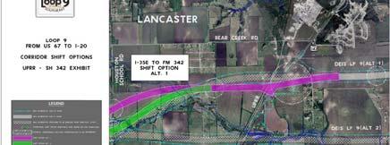
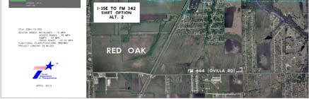
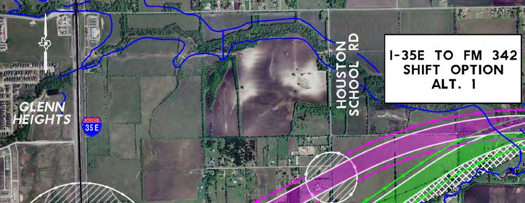
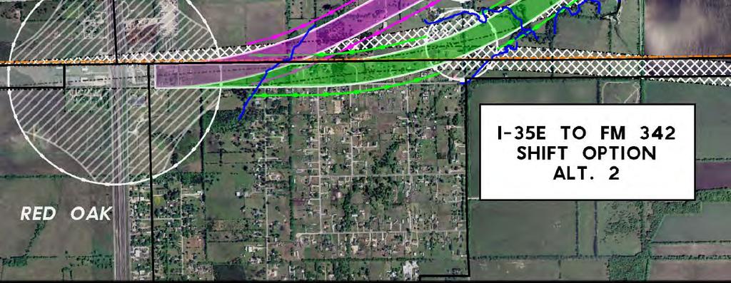
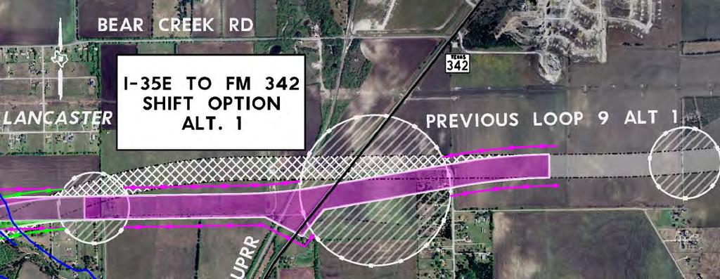
48 Loop 9 at SH 342 Loop 9 at I
49 Updated Loop 9 Website Future Efforts As of April 9, 2013, the Loop 9 website has been updated to include all of the information included within this presentation. 20 Continue efforts to refine the corridor alignment(s) based on community comments Analyze travel demand modeling data to help determine the type of roadway needed, location, and staging Meetings with other stakeholders (e.g., IIPOD, quarries, landfill) Public meeting 10
50 Public Meetings Public Meetings Thurs, May 16 th, 2013 from 5:30pm to 7:30pm Ferris High School 1025 E. 8 th Street Ferris, TX Thurs, May 23 rd, 2013 from 5:30pm to 7:30pm Ovilla Road Baptist Church 3251 Ovilla Road Ovilla, TX X Ferris High School X - Ovilla Road Baptist Church 11
51 COMMENTS & QUESTIONS 12
52 Loop 9 Southeast Corridor/Feasibility Study E4: BNSF
53 Major Stakeholder Meeting Summary Date: April 17, 2013 Time: 11:00 AM 12:00 AM Project: Location: Purpose: Attendees: Loop 9 Southeast BNSF 5800 N. Main Ft. Worth, TX Provide Project Status of Loop 9 Corridor/Feasibility Study See Attachment A for sign-in sheet of all attendees. Attachment A: Sign-in Sheet Attachment B: PowerPoint Presentation/Handout 1. Introductions (see Attachment A for the Sign-in Sheet) Two representatives from BNSF were in attendance to receive an update on the status of the Loop 9 Corridor/Feasibility Study. 2. Presentation (see Attachment B for the PowerPoint Presentation/Handout). Loop 9 project team presented the following: o Introduction o Evolution of Loop 9 o Scope of Loop 9 DEIS o Review of 2035 Traffic Projections o New Approach Corridor Feasibility Study o Study Area o Goals of the Study o Establish New Vision o New Potential Design o Outcome o Project Status o Efforts to Date o Loop 9 Near US 67 o Loop 9 Near SH 342 o Loop 9 at I-45 o Updated Loop 9 Website o Future Efforts 3. Questions/Comments Brian Clark provided hard copy printouts of the presentation. Brian Clark stated the project anticipates two crossings for BNSF and one for UPRR Brian Large confirmed that BNSF shares trackage rights with UPRR, adjacent to I-45. The team looked at the exhibit near Red Oak (SH 342 at UPRR). Brian Large confirmed that BNSF owns the line adjacent to SH 342. The railroad needs 23.5 foot of vertical clearance and no at grade frontage road crossings. The team can a request to Brian Large for the exact ROW width at this location. Brian Clark provided information for the upcoming public meetings. 1
54 BNSF explained that they would like to receive a courtesy copy of the schematic design when the time comes, however, they would not officially need to be updated until final design plans are being developed. 2
55 Attachment A: Sign-in Sheet
56
57 Attachment B: PowerPoint Presentation/Handout
58 LOOP 9 CORRIDOR FEASIBILITY STUDY BNSF STAKEHOLDER MEETING 2 Topics Introduction Evolution of Loop 9 New Approach Corridor Feasibility Study Project Status Comments and Questions 4/17/2013 1
59 Evolution of Loop 9 4 Loop 9 first added to MTP Loop 9 Feasibility Study Phase/MIS led by Dallas County/NCTCOG Dallas County restarts Loop 9 MIS/DEIS TTC Corridor Plan published RTC establishes TTC-35 policy position TxDOT adopts 85 mph design and becomes lead on Loop 9 DEIS Freeway/ROW Preservation Freeway/Parkway ROW Preservation Staged Parkway to EVOLUTION OF LOOP 9 FHWA issues ROD for TTC-35 with the No-Build as the preferred alternative Mobility 2035 approved by RTC Regional Outer Loop Feasibility Study does not recommend a continuous, circumferential Outer Loop TxDOT initiates a corridor feasibility study for Loop 9 FHWA rescinds the NOI to prepare an EIS New Tollway ???????
60 Scope of Loop 9 DEIS Review of 2035 Traffic Projections 5 44 miles long Proposed 450 to 600- foot right-of-way 85 mph design speed Cost: $5.7 billion Loop 9 From: US 287 to IH 20 6 Based on Mobility 2035, estimated traffic volumes were less than half of the previously projected volumes based on Mobility 2030 Reasons for low projected traffic on Loop 9 Toll Lack of Regional Outer Loop to the west Lack of connection to statewide TTC-35 Revised regional demographics Changes to the travel model network New travel model and MPA boundary 3
61 But 7 There still is a need for a east-west facility in South Dallas/North Ellis Counties to provide: Connectivity Travel time savings Potential economic development opportunities CORRIDOR FEASIBILITY STUDY 4
62 9 Study Area North 10 Goals of the Study Solicit input from local and community leaders on specific transportation facility needs Determine the transportation problems within the study area Identify a corridor where transportation projects could be developed to address area problems Identify specific transportation projects to advance in the corridor while considering the potential for impacts on the natural, socio-economic, and cultural environments Recommend a program of transportation projects to advance by priority within the corridor as funding becomes available 5
63 Corridor Feasibility Study Establish New Vision 11 Establish new vision Use information developed d for the DEIS Conduct engineering/right-of-way studies for priority sections Emphasis on the section with the highest traffic volumes (from US 67 to IH 45) and adjacent development potential ti Follow Planning and Environmental Linkages methodology 12 Elements to include: Narrower right-of-way (350 feet vs. 600 feet) Lower design speed (70 mph vs. 85 mph) Context sensitive solutions Access management Flexibility to convert to a full, controlled access facility, if needed d 6
64 New Potential Design Outcome Could allow for innovative finance approach by including toll bridges at cross streets What type of facility is needed Determine effect to other planned transportation facilities Corridor alignment Logical termini Prioritization based on traffic, local needs, and funding Staging (i.e., construction vs. right-of-way preservation) 7
65 Efforts to Date 16 PROJECT STATUS NOI to prepare an EIS rescinded March 20, 2013 Corridor alignments and data from preliminary DEIS are being used and updated Study team has interviewed staff and elected officials from all local governments in the corridor Refinement of corridor alignments is underway Travel demand modeling nearing completion 8


66 Loop 9 at US 67 Loop 9 at SH


67 Loop 9 at I-45 Updated Loop 9 Website As of April the Loop 9 website has As of April 9, 2013, the Loop 9 website has been updated to include all of the information included within this presentation. 10
68 Future Efforts Public Meetings Continue efforts to refine the corridor alignment(s) based on community comments Analyze travel demand modeling data to help determine the type of roadway needed, location, and staging Meetings with other stakeholders (e.g., IIPOD, quarries, landfill) Public meeting Thurs, May 16 th, 2013 from 5:30pm to 7:30pm Ferris High School 1025 E. 8 th Street Ferris, TX Thurs, May 23 rd, 2013 from 5:30pm to 7:30pm Ovilla Road Baptist Church 3251 Ovilla Road Ovilla, TX
69 Public Meetings 23 X - Ovilla Road Baptist Church X Ferris High School COMMENTS & QUESTIONS 12
70 Loop 9 Southeast Corridor/Feasibility Study E5: IIIPOD
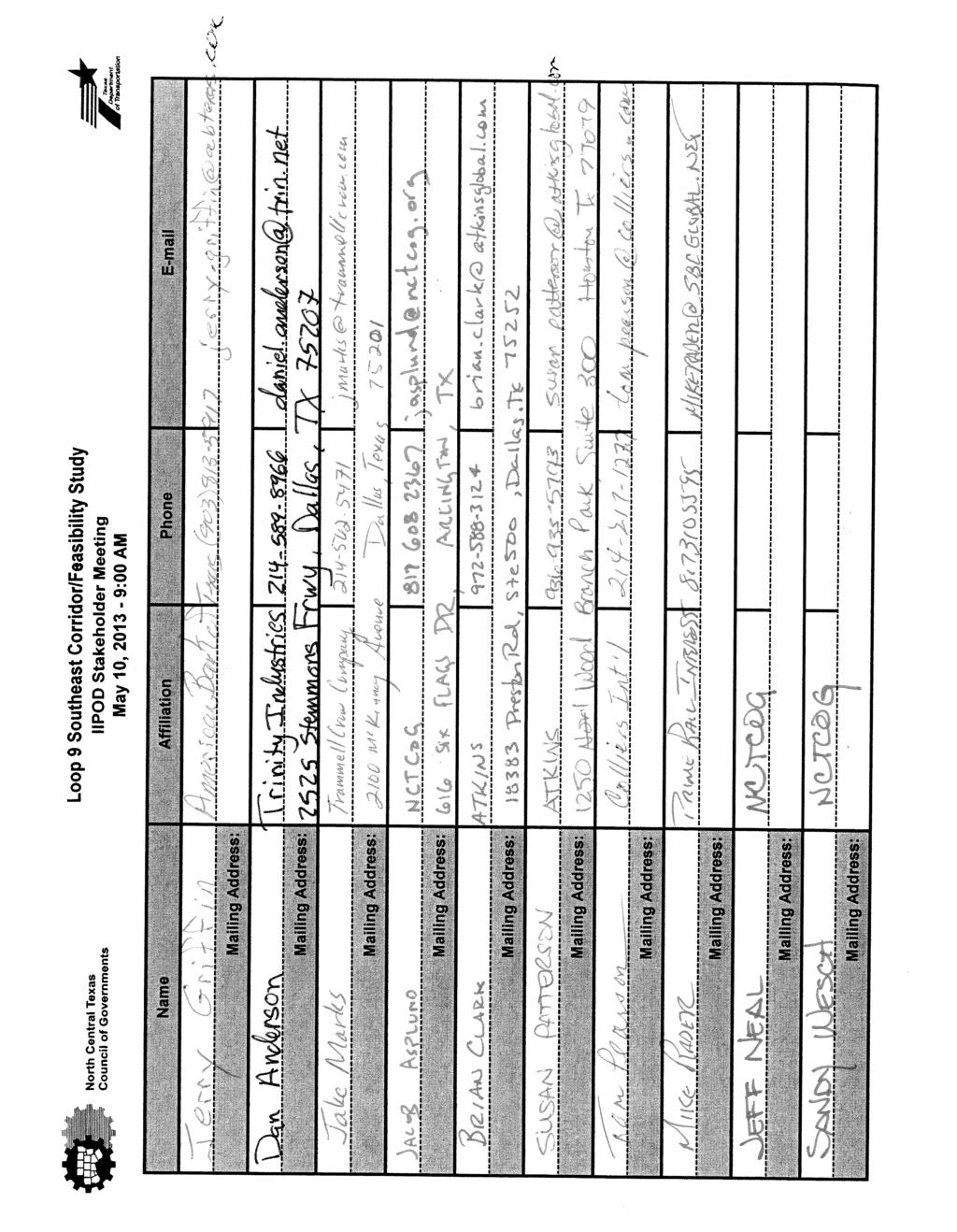
71 Major Stakeholder Meeting Summary Date: May 10, 2013 Time: 9:00 AM 10:00 AM Project: Location: Purpose: Attendees: Loop 9 Southeast North Central Texas Council of Governments Office Six Flags Conference Room 616 Six Flags Drive Arlington, TX Meeting with developers associated with the International Inland Port of Dallas (IIPOD) to provide a status updated on the Loop 9 Corridor/Feasibility Study See Attachment B for sign-in sheet of all attendees. Attachment A: Invitee List Attachment B: Sign-in Sheet Attachment C: PowerPoint Presentation/Handout 1. Introductions (see Attachment A for the Invitee List and Attachment B for the Sign-in Sheet) Representatives from various entities associated with the IIPOD were in attendance to receive an update on the status of the Loop 9 Corridor/Feasibility Study. 2. Presentation (see Attachment C for the PowerPoint Presentation/Handout). Loop 9 project team presented the following: o Introduction o Evolution of Loop 9 o Scope of Loop 9 DEIS o Review of 2035 Traffic Projections o New Approach Corridor Feasibility Study o Study Area o Goals of the Study o Establish New Vision o New Potential Design o Outcome o Project Status o Efforts to Date o Future Efforts 3. Discussion: The group asked about the proposed project schedule and when land acquisition would occur. Brian Clark stated that the first project could be developed within 5-6 years, with land acquisition within the next 2-3 years. A representative from Trammell Crow asked how many stop signs would be located between IH 35 and IH 45. Brian Clark stated that type of design information has not been developed yet. Sandy Wesch discussed the future connections to existing facilities would provide more mobility for the next years and the group discussed how the project would impact the trucking industry. 1
72 A group member asked where possible truck weigh stations would be located along the corridor. The team discussed future technology for the trucking industry and stated that TxDOT may no longer require weigh stations. The group members stated there was a lot of development potential between Ferris and Red Oak and that they were glad to see movement on the proposed project. 2
73 Attachment A: Invitee List
74 Patterson, Susan K Subject: Location: Start: End: Recurrence: Meeting Status: Organizer: Loop 9 Feasibility Study NCTCOG Offices - Six Flags Conference Room Fri 5/10/2013 9:00 AM Fri 5/10/ :00 AM (none) Accepted Sandy Wesch Invitee List: Jeffrey Neal Jacob Asplund dan.tatsch@hillwood.com djohnson@idi.com brice@weeksrobinson.com jeff.thornton@dukerealty.com dan@allengroup.com danschlachter@hotmail.com cwill@sbcglobal.net jgriffin@abtexas.com chris.teesdale@colliers.com tom.pearson@colliers.com randyk@xebecllc.com jnapper@courtlanddev.com jack.todd@trin.net ssanders@iwm-llc.com jswope@championpartners.com asorrels@majesticrealty.com mikerader@sbcglobal.net knewsom@rptrust.com smeyer@prologis.com Hilary Crowell Bruce Nolley Patterson, Susan K Clark, Brian C Karla Weaver skrikorian@trammellcrow.com The Texas Department of Transportation (TxDOT) and North Central Texas Council of Governments (NCTCOG), in cooperation with local government officials, are working together to conduct a corridor feasibility study for the Loop 9 Southeast study area from I-20 to US 67 in Dallas, Ellis, and Kaufman Counties. As part of this study, we would like to provide you and members of your organization with an update on the status of the project and solicit your input. The meeting will be held at the NCTCOG Office located at 616 Six Flags Drive, Arlington, TX For more information on the project, please visit The IS team in Atkins has scanned this and any attachments for viruses and other threats; however no technology can be guaranteed to detect all threats. Always exercise caution before acting on the content of an and before opening attachments or following links contained within the . 1
75 Attachment B: Sign-in Sheet
76
77 Attachment C: PowerPoint Presentation/Handout
78 LOOP 9 CORRIDOR FEASIBILITY STUDY 5/10/2013
79 Topics 2 Introduction Evolution of Loop 9 New Approach Corridor Feasibility Study Project Status Comments and Questions
80 EVOLUTION OF LOOP 9
81 Evolution of Loop 9 4 Loop 9 first added to MTP Loop 9 Feasibility Study Phase/MIS led by Dallas County/NCTCOG Dallas County restarts Loop 9 MIS/DEIS TTC Corridor Plan published RTC establishes TTC-35 policy position TxDOT adopts 85 mph design and becomes lead on Loop 9 DEIS Freeway/ROW Preservation Freeway/Parkway ROW Preservation to Staged Parkway 2006 FHWA issues ROD for TTC-35 with the No-Build as the preferred alternative Mobility 2035 approved by RTC Regional Outer Loop Feasibility Study does not recommend a continuous, circumferential Outer Loop TxDOT initiates a corridor feasibility study for Loop 9 FHWA rescinds the NOI to prepare an EIS New Tollway ??????? 2013


82 Scope of Loop 9 DEIS 5 44 miles long Loop 9 From: US 287 to IH 20 Proposed 450 to 600- foot right-of-way 85 mph design speed Cost: $5.7 billion

83 Review of 2035 Traffic Projections 6 Based on Mobility 2035, estimated traffic volumes were less than half of the previously projected volumes based on Mobility 2030 Reasons for low projected traffic on Loop 9 Toll Lack of Regional Outer Loop to the west Lack of connection to statewide TTC-35 Revised regional demographics Changes to the travel model network New travel model and MPA boundary
84 But 7 There still is a need for a east-west facility in South Dallas/North Ellis Counties to provide: Connectivity Travel time savings Potential economic development opportunities
85 CORRIDOR FEASIBILITY STUDY

86 Study Area 9 North
87 Goals of the Study 10 Solicit input from local and community leaders on specific transportation facility needs Determine the transportation problems within the study area Identify a corridor where transportation projects could be developed to address area problems Identify specific transportation projects to advance in the corridor while considering the potential for impacts on the natural, socio-economic, and cultural environments Recommend a program of transportation projects to advance by priority within the corridor as funding becomes available
88 Corridor Feasibility Study 11 Establish new vision Use information developed for the DEIS Conduct engineering/right-of-way studies for priority sections Emphasis on the section with the highest traffic volumes (from US 67 to IH 45) and adjacent development potential Follow Planning and Environmental Linkages methodology
89 Establish New Vision 12 Elements to include: Narrower right-of-way (350 feet vs. 600 feet) Lower design speed (70 mph vs. 85 mph) Context sensitive solutions Access management Flexibility to convert to a full, controlled access facility, if needed

90 Potential Phased Approach to Allow for Innovative Financing 13 PHASE 1: Two-Way Frontage Road PHASE 2: One-Way Frontage Roads RIGHT-OF-WAY FOR FUTURE EXPANSION PHASE 3: Tolled Grade Separation PHASE 4: Continuous Toll Road Legend Tolled Main Lanes Major Arterial Cross Street Two-Way Frontage Roads One-Way Frontage Roads Toll Road Access Ramps Space for Future Lanes Turn Lanes Grade Separation Lane Boundaries and Edge of Pavement
91 Outcome 14 What type of facility is needed Determine effect to other planned transportation facilities Corridor alignment Logical termini Prioritization based on traffic, local needs, and funding Staging (i.e., construction vs. right-of-way preservation)
92 PROJECT STATUS
93 Efforts to Date 16 NOI to prepare an EIS rescinded March 20, 2013 Corridor alignments and data from preliminary DEIS are being used and updated Study team has interviewed staff and elected officials from all local governments in the corridor Refinement of corridor alignments is underway Travel demand modeling nearing completion
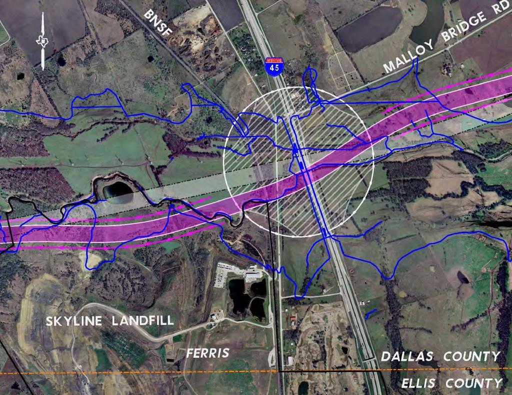
94

95 18
96 19
97 20
98 Future Efforts 21 Continue efforts to refine the corridor alignment(s) based on community comments Analyze travel demand modeling data to help determine the type of roadway needed, location, and staging Upcoming public meetings: Thursday, May 16, :30 p.m. to 7:30 p.m. Ferris High School 1025 E. 8th Street Ferris, TX Thursday, May 23, :30 p.m. to 7:30 p.m. Ovilla Road Baptist Church 3251 Ovilla Road Ovilla, TX 75154
99 COMMENTS & QUESTIONS
100 Loop 9 Southeast Corridor/Feasibility Study E6: Skyline Landfill
101 Major Stakeholder Meeting Summary Date: May 16, 2013 Time: 2:00 PM 3:00 PM Project: Location: Purpose: Attendees: Loop 9 Southeast Skyline Landfill 1201 N Central Street Ferris, TX Provide Project Status of Loop 9 Corridor/Feasibility Study See Attachment A for sign-in sheet of all attendees. Attachment A: Sign-in Sheet Attachment B: PowerPoint Presentation/Handout 1. Introductions (see Attachment A for the Sign-in Sheet) Representatives from Waste Management were in attendance to receive an update on the status of the Loop 9 Corridor/Feasibility Study. 2. Presentation (see Attachment B for the PowerPoint Presentation/Handout). Loop 9 project team presented the following: o Introduction o Evolution of Loop 9 o Scope of Loop 9 DEIS o Review of 2035 Traffic Projections o New Approach Corridor Feasibility Study o Study Area o Goals of the Study o Establish New Vision o New Potential Design o Outcome o Project Status o Efforts to Date o Loop 9 Near Skyline Landfill o Future Efforts 3. Discussion: The group reviewed the proposed project location layout and discussed the following: Ruth Muelker asked why the pink alternative was created to the south of the previous alternatives they had seen. Brian Clark explained it was another option created to avoid the high power transmission lines located north of the landfill. Landfill representatives stated the property boundaries for the landfill have not changed since the last meeting. Ruth Muelker stated that their concerns are the same as previously discussed and they are still considered significant impacts to their facility. She asked if the team had met with the City of Ferris since the impacts to the landfill would impact their revenue (they currently receive $1M/year). Brian Clark summarized the Task Force Meetings held in Representatives from the City of Ferris were in attendance. 1
102 Charles Rivette stated that their preference is to move the alignment as far north as possible to avoid financial, regulatory, and planning impacts to their facility. Brian Clark asked the group if the structure was elevated would the impacts be the same. Ruth Muelker stated the impacts would still be problematic due to groundwater issues, environmental regulations, and buffer distances. Waste Management presented a map showing the property boundaries and current landfill areas and stated they would send a copy to Atkins for their files. Ruth Muelker stated that if the landfill was to be impacted by the roadway, they would have to apply for a revised landfill permit with different buffer and drainage requirements. The group also discussed the location of a USACE permitted wetland mitigation area on the site. The group was unsure of the location on the area but would notify TxDOT of its location. Waste Management has already submitted a revised permit for the landfill to accommodate the original alignment for Loop 9 and for their future planning purposes (relocation of power lines to the south, revised buffers, etc.). The permit is in review and has not been approved yet. The permit approval can take 18 months to 5 years. Waste Management stated they preferred Alternative G at a 350 foot ROW width. Alternative H would impact the landfill and trigger additional permit revisions. Three water monitoring wells are located along the north side of the landfill within Alternative H alignment. Alternative H would also impact the Waste Management hauling facility. Ruth Muelker expressed concern that TxDOT would have to assume responsibility for the landfill property to be impacted, including closure and post-closure care and monitoring plans. She stated the responsibility would be for at least 20 years. Waste Management stated they felt the project was important and their facility would benefit from better access in the future. 2
103 Attachment A: Sign-in Sheet
104
105 Attachment B: PowerPoint Presentation/Handout
106 Skyline Landfill Stakeholder Meeting 5/16/2013 LOOP 9 CORRIDOR FEASIBILITY STUDY SKYLINE LANDFILL STAKEHOLDER MEETING 5/16/2013 Topics 2 Introduction Evolution of Loop 9 New Approach Corridor Feasibility Study Project Status Comments and Questions 1
107 Skyline Landfill Stakeholder Meeting 5/16/2013 EVOLUTION OF LOOP 9 4 Evolution of Loop 9 Loop 9 first added to MTP Loop 9 Feasibility Study Phase/MIS led by Dallas County/NCTCOG Dallas County restarts Loop 9 MIS/DEIS TTC Corridor Plan published RTC establishes TTC-35 policy position TxDOT adopts 85 mph design and becomes lead on Loop 9 DEIS Freeway/ROW Preservation Freeway/Parkway ROW Preservation Staged Parkway to FHWA issues ROD for TTC-35 with the No-Build as the preferred alternative Mobility 2035 approved by RTC Regional Outer Loop Feasibility Study does not recommend a continuous, circumferential Outer Loop TxDOT initiates a corridor feasibility study for Loop 9 FHWA rescinds the NOI to prepare an EIS New Tollway ???????


108 Skyline Landfill Stakeholder Meeting 5/16/ Scope of Loop 9 DEIS 44 miles long Proposed 450 to 600- foot right-of-way 85 mph design speed Cost: $5.7 billion Loop 9 From: US 287 to IH 20 Review of 2035 Traffic Projections 6 Based on Mobility 2035, estimated traffic volumes were less than half of the previously projected volumes based on Mobility 2030 Reasons for low projected traffic on Loop 9 Toll Lack of Regional Outer Loop to the west Lack of connection to statewide TTC-35 Revised regional demographics Changes to the travel model network New travel model and MPA boundary 3
109 Skyline Landfill Stakeholder Meeting 5/16/2013 But 7 There still is a need for a east-west facility in South Dallas/North Ellis Counties to provide: Connectivity Travel time savings Potential economic development opportunities CORRIDOR FEASIBILITY STUDY 4
110 Skyline Landfill Stakeholder Meeting 5/16/ Study Area North Goals of the Study 10 Solicit input from local and community leaders on specific transportation facility needs Determine the transportation problems within the study area Identify a corridor where transportation projects could be developed to address area problems Identify specific transportation projects to advance in the corridor while considering the potential for impacts on the natural, socio-economic, and cultural environments Recommend a program of transportation projects to advance by priority within the corridor as funding becomes available 5
111 Skyline Landfill Stakeholder Meeting 5/16/2013 Corridor Feasibility Study 11 Establish new vision Use information developed d for the DEIS Conduct engineering/right-of-way studies for priority sections Emphasis on the section with the highest traffic volumes (from US 67 to IH 45) and adjacent development potential ti Follow Planning and Environmental Linkages methodology Establish New Vision 12 Elements to include: Narrower right-of-way (350 feet vs. 600 feet) Lower design speed (70 mph vs. 85 mph) Context sensitive solutions Access management Flexibility to convert to a full, controlled access facility, if needed d 6

112 Skyline Landfill Stakeholder Meeting 5/16/2013 New Potential Design 13 Could allow for innovative finance approach by including toll bridges at cross streets Outcome 14 What type of facility is needed Determine effect to other planned transportation facilities Corridor alignment Logical termini Prioritization based on traffic, local needs, and funding Staging (i.e., construction vs. right-of-way preservation) 7
113 Skyline Landfill Stakeholder Meeting 5/16/2013 PROJECT STATUS Efforts to Date 16 NOI to prepare an EIS rescinded March 20, 2013 Corridor alignments and data from preliminary DEIS are being used and updated Study team has interviewed staff and elected officials from all local governments in the corridor Refinement of corridor alignments is underway Travel demand modeling nearing completion 8


114 Skyline Landfill Stakeholder Meeting 5/16/ Loop 9 near I Updated Loop 9 Website 18 As of April the Loop 9 website has As of April 9, 2013, the Loop 9 website has been updated to include all of the information included within this presentation. 9
115 Skyline Landfill Stakeholder Meeting 5/16/2013 Future Efforts 19 Continue efforts to refine the corridor alignment(s) based on community comments Analyze travel demand modeling data to help determine the type of roadway needed, location, and staging Meetings with other stakeholders (e.g., IIPOD, quarries, landfill) Public meeting Public Meetings 20 Thurs, May 16 th, 2013 from 5:30pm to 7:30pm Ferris High School 1025 E. 8 th Street Ferris, TX Thurs, May 23 rd, 2013 from 5:30pm to 7:30pm Ovilla Road Baptist Church 3251 Ovilla Road Ovilla, TX


116 Skyline Landfill Stakeholder Meeting 5/16/ Public Meetings X - Ovilla Road Baptist Church X Ferris High School COMMENTS & QUESTIONS 11
117 Loop 9 Southeast Corridor/Feasibility Study E7: Oncor
118 Major Stakeholder Meeting Summary Date: August 5, 2013 Time: 2:00 PM 3:00 PM Project: Location: Purpose: Attendees: Loop 9 Southeast Oncor 115 W. 7 th Street, Suite 625 Fort Worth, TX Provide Project Status of Loop 9 Corridor/Feasibility Study Bruce Nolley, TxDOT Brian Clark, Atkins Susan Patterson, Atkins Jeff Neal, NCTCOG Jim Chase, Oncor Bryan Williams, Oncor Attachment A: PowerPoint Presentation/Handout 1. Introductions Representatives from Oncor were in attendance to receive an update on the status of the Loop 9 Corridor/Feasibility Study. 2. Presentation (see Attachment B for the PowerPoint Presentation/Handout). Loop 9 project team presented the following: o Introduction o Evolution of Loop 9 o Scope of Loop 9 DEIS o Review of 2035 Traffic Projections o New Approach Corridor Feasibility Study o Study Area o Goals of the Study o Establish New Vision o New Potential Design o Outcome o Project Status o Efforts to Date o Future Efforts 3. Questions/Comments Jim Chase stated that the original cost for Loop 9 was $5.7 billion and asked what is the cost now. Brian Clark stated that cost estimates are currently being evaluated. Jim Chase asked which segment would be first. Bruce Nolley stated that is still to be determined. Jim Chase stated that ROW acquisition would drive the schedule for Oncor s relocation efforts. 1
119 Bryan Williams stated that TxDOT would not want a Oncor structures within their ROW and they might need an exception to TxDOT policy. The team discussed the process of realigning the utilities and timing. Oncor must request the alignment change from the Public Utility Commission (PUC). The team discussed how far the utility lines can be spanned. Oncor stated that the large towers can span ft. The smaller H frame ones can span ft. Brian Clark asked if the utility lines can be raised. Bryan Williams stated that some can be raised, but there are limitations. There is a 200 ft ceiling height. The team agreed that coordination of impacts can occur at any time, but they can t do anything until the ROW acquisition process begins and TxDOT owns the ROW. Jim Chase noted approximately a dozen locations of impacts to distribution lines and 8-10 locations of impacts for transmission lines. 2
120 Attachment A: PowerPoint Presentation/Handout
121 8/5/13 LOOP 9 CORRIDOR FEASIBILITY STUDY ONCOR STAKEHOLDER MEETING 2 Topics Introduction Evolution of Loop 9 New Approach Corridor Feasibility Study Project Status Comments and Questions 8/05/2013 1
122 8/5/13 Evolution of Loop 9 4 Loop 9 first added to MTP Loop 9 Feasibility Study Phase/MIS led by Dallas County/NCTCOG Dallas County restarts Loop 9 MIS/DEIS TTC Corridor Plan published RTC establishes TTC-35 policy position TxDOT adopts 85 mph design and becomes lead on Loop 9 DEIS Freeway/ROW Preservation Freeway/Parkway ROW Preservation Staged Parkway to EVOLUTION OF LOOP 9 FHWA issues ROD for TTC-35 with the No-Build as the preferred alternative Mobility 2035 approved by RTC Regional Outer Loop Feasibility Study does not recommend a continuous, circumferential Outer Loop TxDOT initiates a corridor feasibility study for Loop 9 FHWA rescinds the NOI to prepare an EIS New Tollway ???????

123 8/5/13 Scope of Loop 9 DEIS Review of 2035 Traffic Projections 5 44 miles long Proposed 450 to 600- foot right-of-way 85 mph design speed Cost: $5.7 billion Loop 9 From: US 287 to IH 20 6 Based on Mobility 2035, estimated traffic volumes were less than half of the previously projected volumes based on Mobility 2030 Reasons for low projected traffic on Loop 9 Toll Lack of Regional Outer Loop to the west Lack of connection to statewide TTC-35 Revised regional demographics Changes to the travel model network New travel model and MPA boundary 3
124 8/5/13 But 7 There still is a need for a east-west facility in South Dallas/North Ellis Counties to provide: Connectivity Travel time savings Potential economic development opportunities CORRIDOR FEASIBILITY STUDY 4

125 8/5/13 9 Study Area North 10 Goals of the Study Solicit input from local and community leaders on specific transportation facility needs Determine the transportation problems within the study area Identify a corridor where transportation projects could be developed to address area problems Identify specific transportation projects to advance in the corridor while considering the potential for impacts on the natural, socio-economic, and cultural environments Recommend a program of transportation projects to advance by priority within the corridor as funding becomes available 5
126 8/5/13 Corridor Feasibility Study Establish New Vision 11 Establish new vision Use information developed d for the DEIS Conduct engineering/right-of-way studies for priority sections Emphasis on the section with the highest traffic volumes (from US 67 to IH 45) and adjacent development potential ti Follow Planning and Environmental Linkages methodology 12 Elements to include: Narrower right-of-way (350 feet vs. 600 feet) Lower design speed (70 mph vs. 85 mph) Context sensitive solutions Access management Flexibility to convert to a full, controlled access facility, if needed d 6

127 8/5/13 New Potential Design Outcome Could allow for innovative finance approach by including toll bridges at cross streets What type of facility is needed Determine effect to other planned transportation facilities Corridor alignment Logical termini Prioritization based on traffic, local needs, and funding Staging (i.e., construction vs. right-of-way preservation) 7
128 8/5/13 Efforts to Date 16 PROJECT STATUS NOI to prepare an EIS rescinded March 20, 2013 Corridor alignments and data from preliminary DEIS are being used and updated Study team has interviewed staff and elected officials from all local governments in the corridor Refinement of corridor alignments is underway Travel demand modeling nearing completion 8

 based on")


 Held two public")
129 8/5/13 Efforts to Date Loop 9 near I-45 DEIS Concept 17 Refined the corridor alignment(s) based on community comments Analyzed travel demand modeling data to help determine the type of roadway needed Met with other stakeholders (IIPOD, UPRR, BNSF, Skyline Landfill, Trinity River Authority) Held two public meetings (Ferris and Ovilla) 18 9


130 8/5/13 Loop 9 near I-45 Feasibility Study Updated Loop 9 Website As of April the Loop 9 website has As of April 9, 2013, the Loop 9 website has been updated to include all of the information included within this presentation. 10
Appendix F Public Meeting Summaries. F1: May 2013 Public Meeting Summary F2: September 2013 Public Meeting Summary
 Loop 9 Southeast Corridor/Feasibility Study Appendix F Public Meeting Summaries F1: May 2013 Public Meeting Summary F2: September 2013 Public Meeting Summary Loop 9 Southeast Corridor/Feasibility Study
PUBLIC MEETING. For I-10 East, I-410 to Loop 1604
 PUBLIC MEETING For I-10 East, I-410 to Loop 1604 November 3, 2016 Welcome Thank you for participating in the Public Meeting for the proposed I-10 East, I-410 to Loop 1604 Project. The meeting is in an
STATE HIGHWAY (SH) 34 FEASIBILITY STUDY PUBLIC MEETING
 34 FEASIBILITY STUDY PUBLIC MEETING") STATE HIGHWAY (SH) 34 FEASIBILITY STUDY PUBLIC MEETING From FM 2578 in Terrell to SH 243 in Kaufman CSJ: 0173-04-056 June 28, 2018 WHAT IS A FEASIBILITY STUDY WHAT IS A FEASIBILITY STUDY? A feasibility
STATE HIGHWAY (SH) 34 FEASIBILITY STUDY PUBLIC MEETING From FM 2578 in Terrell to SH 243 in Kaufman CSJ: 0173-04-056 June 28, 2018 WHAT IS A FEASIBILITY STUDY WHAT IS A FEASIBILITY STUDY? A feasibility
I-69 Corridor Segment Committee 1 and 2 Kick-off Meeting April 15 Nacogdoches, Texas
 I-69 Corridor Segment Committee 1 and 2 Kick-off Meeting April 15 Nacogdoches, Texas 10:00 a.m. Welcome/ Introductions Mark Tomlinson Division Dir., Texas Turnpike Authority Div, TxDOT 10:15 a.m. Presentations
REQUEST FOR INFORMATION
 REQUEST FOR INFORMATION REGARDING THE DEVELOPMENT OF AND PROCUREMENT PROCESS FOR THE GRAND PARKWAY PROJECT TEXAS DEPARTMENT OF TRANSPORTATION RFI Issuance Date: June 10, 2011 RFI Closing Date: July 6,
REGIONAL 10-YEAR PLAN AND NEXT DECADE OF PROJECTS. Regional Transportation Council December 8, 2016
 REGIONAL 10-YEAR PLAN AND NEXT DECADE OF PROJECTS Regional Transportation Council December 8, 2016 POLICY SUMMARY Thank the Texas Transportation Commission for formula funds. Thank the Legislature and
ENVIRONMENTAL STATUS OF THE US 59/LOOP 20/I-69W PROJECT
 ENVIRONMENTAL STATUS OF THE US 59/LOOP 20/I-69W PROJECT A Brief Overview As Of June 15, 2015 Mike Graham Laredo District Environmental Coordinator June 15, 2015 Projects Locations & Design: Additional
August 2007 Thomas Bohuslav Texas Department of Transportation
 Public Private Partnerships Activities in Texas AASHTO SOC 2007 Summer Meeting Biloxi Mississippi August 2007 Thomas Bohuslav Texas Department of Transportation Topics The Problem (Needs) Comprehensive
Welcome to the Public Meeting for the State Highway 68 Project. SH 68 Project Office Information Environmental Constraints & Study Corridors
 Welcome to the Public Meeting for the State Highway 68 Project ENTRANCE EXIT Registration & Handouts Comment Card Area Welcome Video Next Steps Project History Information Environmental Constraints & Study
Texas Department of Transportation Corpus Christi District
 Texas Department of Transportation Corpus Christi District U.S. 181 Harbor Bridge Project Environmental Documentation and Schematic Development Public Scoping Meeting August 9, 2011 Welcome John A. Casey,
Tentative Project Schedule. Non-Discrimination i i Laws. Para Preguntas en español
 Florida Department of Transportation, District Seven Project Newsletter Number 1 October 2012 The Florida Department of Transportation (FDOT) is conducting a Project Development & Environment (PD&E) study
Apologies Michael, but lets work off of the attached update version. James Bass came back with a few additional minor tweaks to the language.
 REFERENCE ITEM 3.16 RTC Handout March 8, 2018 From: To: Cc: Subject: Date: Attachments: Marc Williams Michael Morris Bill Hale; Kelly Selman; Mo Bur; Brian Barth RE: Recommended RTC Action for LBJ/IH 635
Strategic Projects Division
 Strategic Projects Division DESIGN BUILD: The Texas Story 2012 AASHTO Conference May 2, 2012 Portland, Oregon Don Toner, Jr., SRWA Director Strategic Projects Right of Way Strategic Projects Division Texas
Welcome to the WebEx. The presentation for the 2019 Unified Transportation Program (UTP) Public Meeting will begin shortly.
 Public Meeting will begin shortly.") Welcome to the WebEx. The presentation for the 2019 Unified Transportation Program (UTP) Public Meeting will begin shortly. We will take questions after the presentation, however, you may enter questions
Welcome to the WebEx. The presentation for the 2019 Unified Transportation Program (UTP) Public Meeting will begin shortly. We will take questions after the presentation, however, you may enter questions
In-Step, In Line, On Time. Robert F. Tally Jr. FHWA Indiana Division Administrator Monday, November 16, 2009
 In-Step, In Line, On Time Robert F. Tally Jr. FHWA Indiana Division Administrator Monday, November 16, 2009 I-69 Corridor 1 I-69 Corridor I-69 is expected to create more than 27,000 new jobs by 2025, resulting
NORTH CENTRAL TEXAS COUNCIL OF GOVERNMENTS METROPOLITAN PLANNING ORGANIZATION REQUEST FOR PROPOSALS
 NORTH CENTRAL TEXAS COUNCIL OF GOVERNMENTS METROPOLITAN PLANNING ORGANIZATION REQUEST FOR PROPOSALS CITY OF CEDAR HILL CITY CENTER TRANSIT-ORIENTED DEVELOPMENT PLAN August 19, 2011 REQUEST FOR PROPOSALS
STATEWIDE TRANSPORTATION IMPROVEMENT PROGRAM FY Amarillo District May FY 2010 Quarterly Revisions
 STATEWIDE TRANSPORTATION IMPROVEMENT PROGRAM FY 2008-2011 Amarillo District May FY 2010 Quarterly Revisions 5-2010 MONDAY, APRIL 26, 2010 STATEWIDE TRANSPORTATION IMPROVEMENT PROGRAM PAGE: 1 OF 1 11:21:55
School Siting and Transportation
 School Siting and Transportation City of Denton and Denton ISD March 5, 2012 North Central Texas Council of Governments Common Goal All schools should provide a safe and healthy learning environment with
SCOTT COUNTY COMMUNITY SERVICES DIVISION
 SCOTT COUNTY COMMUNITY SERVICES DIVISION PHYSICAL DEVELOPMENT 600 COUNTRY TRAIL EAST JORDAN, MN 55352-9339 (952) 496-8346 Fax: (952) 496-8365 www.co.scott.mn.us MITCHELL J. RASMUSSEN, P.E. COUNTY ENGINEER
Appendix E Federal and State Funding Categories
 Appendix E Federal and State Funding Categories This page left blank intentionally. Federal and State Funding Categories Appendix E E 3 Appendix E Federal and State Funding Categories Highway Programs
Katy Trail Extension from McCommas Boulevard to White Rock Station
 Katy Trail Extension from McCommas Boulevard to White Rock Station Presented to the Quality of Life Committee By Public Works and Transportation October 26, 2009 Purpose of Briefing Provide updates on
Appendix A: Public Involvement Plan
 Appendix A: Public Involvement Plan RM 620 Corridor Improvement Study Appendix A Draft Public Involvement Plan RM 620 Feasibility Study US 183 to SH 71 Williamson and Travis Counties CSJs: 0683-02-062,
US 59 Diboll Relief Route (Future I-69) Angelina County Open House Summary and Comment Response Report March 3, 2015
 Angelina County Open House Summary and Comment Response Report March 3, 2015") US 59 Diboll Relief Route (Future I-69) Angelina County Open House Summary and Comment Response Report March 3, 2015 Texas Department of Transportation, Lufkin District The environmental review, consultation,
US 59 Diboll Relief Route (Future I-69) Angelina County Open House Summary and Comment Response Report March 3, 2015 Texas Department of Transportation, Lufkin District The environmental review, consultation,
2013 Louisiana Transportation Conference
 February 20, 2013 Baton Rouge River Center 2013 Louisiana Transportation Conference Partnerships for Progress in Transportation Mega Projects Session (I-12 to Bush) I-12 to Bush Agenda Inclusion into TIMED
Tower 55 Rail Reliever Study
 Tower 55 Rail Reliever Study Technical Advisory Group June 19, 2009 Meeting Agenda Welcome & Introductions Approval of the April 17, 2009 Meeting Minutes Review of Project s s Goals & Objectives Status
NORTH CENTRAL TEXAS COUNCIL OF GOVERNMENTS METROPOLITAN PLANNING ORGANIZATION REQUEST FOR PROPOSALS
 NORTH CENTRAL TEXAS COUNCIL OF GOVERNMENTS METROPOLITAN PLANNING ORGANIZATION REQUEST FOR PROPOSALS TO DEVELOP A STRATEGIC INTELLIGENT TRANSPORTATION SYSTEM DEPLOYMENT PLAN May 1, 2015 Page 1 of 13 REQUEST
AGENDA. Regional Transportation Council Thursday, September 13, 2018 North Central Texas Council of Governments
 AGENDA Regional Transportation Council Thursday, September 13, 2018 North Central Texas Council of Governments 11:30 am Auto Occupancy Detection Technology Rewards Program and Tolled Managed Lanes Policy
A DEFINITIONS AND ACRONYMS
 Exhibit A DEFINITIONS AND ACRONYMS Addenda/Addendum means supplemental additions, deletions, and modifications to the provisions of the RFP after the release date of the RFP. Adjusted Available Public
NCDOT Planning Summary for NCTA Projects
 NCDOT Planning Summary for NCTA Projects Page 1 Triangle Expressway Southeast Extension Wake and Johnston Counties (STIP Projects R-2721, R-2828, and R-2829) The Triangle Expressway Southeast Extension
MINUTES. Regional Transportation Council PUBLIC MEETING. Kaufman County Regional Toll Revenue Transportation Funding Initiative Recommendations
 DRAFT MINUTES Regional Transportation Council PUBLIC MEETING Kaufman County Regional Toll Revenue Transportation Funding Initiative Recommendations Meeting Date and Location The North Central Texas Council
SH 121: FM 423 To SH 121 At US 75 Interchange. APPENDIX B: Coordination and Policy
 Re-evaluation SH 121: FM 423 To SH 121 At US 75 Interchange APPENDIX B: Coordination and Policy Revised 10/4/2007 RESOLUTION NO. 2431-8-05(R) A RESOLUTION OF THE CITY COUNCIL OF THE CITY OF ALLEN, COLLIN
PROJECT SELECTION Educational Series
 PROJECT SELECTION 2017 Educational Series PROJECT SELECTION THE PROJECT SELECTION PROCESS Understanding how the state s roads, bridges and other transportation infrastructure are selected for funding helps
I-15/Tropicana Interchange Feasibility Study in Clark County, NV. Comments are due October 16, 2015, 5 p.m.
 Welcome Nevada Department of Transportation Public Meeting I-15/Tropicana Interchange Feasibility Study in Clark County, NV Ways to Comment Tonight Comment during public meeting Court reporter Comment
Meeting Minutes. Project: Subject: Date: Wednesday, December 16, 2015 Location: Attendees:
 Meeting Minutes Project: Subject: DART D2 Stakeholder Work Group for D2 Date: Wednesday, December 16, 2015 Location: Attendees: DART, 1401 Pacific Avenue, Dallas, TX Steve Salin, DART Ernie Martinez, DART
Module 2 Planning and Programming
 Module 2 Planning and Programming Contents: Section 1 Overview... 2-2 Section 2 Coordination with MPO... 2-4 Section 3 Functional Classification... 2-6 Section 4 Minute Order for Designation as Access
Memorandum CITY OF DALLAS. February 1, Honorable Mayor and Members of the City Council
 Memorandum CITY OF DALLAS February 1, 2013 Honorable Mayor and Members of the City Council S.M Wright Project and Job Opportunity Regional Pilot Program On Wednesday, February 6, 2013, the City Council
Capital Circle Southwest (SR 263)
") Capital Circle Southwest (SR 263) from Crawfordville Road (US 319) to Blountstown Highway (SR 20) Tallahassee, Florida FPID 415782-4 Public Hearing December 4, 2014 This Public Hearing is being held in
Capital Circle Southwest (SR 263) from Crawfordville Road (US 319) to Blountstown Highway (SR 20) Tallahassee, Florida FPID 415782-4 Public Hearing December 4, 2014 This Public Hearing is being held in
STATEWIDE TRANSPORTATION IMPROVEMENT PROGRAM FY AMARILLO DISTRICT. AUGUST FY 2009 Quarterly Revisions
 STATEWIDE TRANSPORTATION IMPROVEMENT PROGRAM FY 2008-2011 AMARILLO DISTRICT AUGUST FY 2009 Quarterly Revisions 8-01-2009 MINUTES AMARILLO METROPOLITAN PLANNING ORGANIZATION POLICY ADVISORY COMMITTEE MEETING
SMALL CITY PROGRAM. ocuments/forms/allitems.
 SMALL CITY PROGRAM The Small City Program provides Federal funds to small cities with populations from 5,000 to 24,999 that are NOT located within Metropolitan Planning Organizations' boundaries. Currently
SOUTHWEST LRT (METRO GREEN LINE EXTENSION)
") 10 Joint Development This chapter describes potential long-term direct and indirect and short-term (construction) direct and indirect effects that would result from the Southwest Light Rail Transit (LRT)
10 Joint Development This chapter describes potential long-term direct and indirect and short-term (construction) direct and indirect effects that would result from the Southwest Light Rail Transit (LRT)
Public Meeting #5 Summary
 Public Meeting #5 Summary Pulaski County, Arkansas February 4, 2016 TABLE OF CONTENTS 1.0 Introduction... 1 2.0 Public Meeting #5... 1 2.1 Public Meeting Advertising and Outreach... 2 2.2 Public Meeting
NEPA PUBLIC INVOLVEMENT
 NEPA PUBLIC INVOLVEMENT Anita Bradley, Environmental Affairs Division TxDOT Environmental Conference 2017 Table of Contents 1 What is TxDOT role in NEPA and What is Public Involvement 2 85 th State Legislature
Pecue Lane/I-10 Interchange Project Public Meeting Transcript
 Pecue Lane/I-10 Interchange Project Public Meeting Transcript Thursday, November 4, 2010 Associated Builders & Contractors 19251 Highland Road 4:30pm 7:30pm 20 attendees Representatives from the Louisiana
I-69 Angelina and Nacogdoches Counties Committee Charge and Purpose
 AGENDA I-69 Angelina and Nacogdoches Counties Committee Tuesday, January 22, 2013 2-5 pm TxDOT Lufkin District 1805 N. Timberland Drive Lufkin, TX 75901 MEETING OBJECTIVE: Review, discuss and understand
FFY Transportation Improvement Program
 Lawton Metropolitan Planning Organization DRAFT FFY 2018-2021 Transportation Improvement Program Approved, 2017 The Federal Fiscal Years (FFY) 2018-2021 Transportation Improvement Program (TIP) is updated
WORK SESSION ITEM City Council
 DATE: STAFF: October 25, 2016 Mark Jackson, PDT Deputy Director WORK SESSION ITEM City Council SUBJECT FOR DISCUSSION I-25 Northern Colorado Improvements. EXECUTIVE SUMMARY The purpose of this item is
Guidance. Historical Studies Review Procedures
 Guidance Historical Studies Review Procedures This guidance document provides instructional material regarding how to review and process project activities in accordance with TxDOT s Section 106 of the
8. Coordination and Consultation
 8. Coordination and Consultation A Public Involvement Strategy was developed for this project. The strategy was prepared following interviews with 10 key stakeholders to assess information needs and appropriate
CITY OF LA CENTER PUBLIC WORKS
 CITY OF LA CENTER PUBLIC WORKS TRAFFIC CALMING PROGRAM APPROVED PER RESOLUTION 08-304 ON DECEMBER 10, 2008 TABLE OF CONTENTS PAGE Summary... 1 Procedures... 2 Project Eligibility... 2 Project Funding &
IH 20 Ranger Hill Schematic Design and Environmental Documentation CSJ:
 IH 20 Ranger Hill Schematic Design and Environmental Documentation CSJ: 0007-06-084 Project Limits From approximately 3.5 miles east of Loop 254 To SH 16 Public Meeting Summary DATE/TIME: August 25, 2015;
Dallas North Tollway Extension Phase 4B/5A Alignment Presented to: Regional Transportation Council
 Dallas North Tollway Extension Phase 4B/5A Alignment Presented to: Regional Transportation Council Gerry Carrigan Assistant Executive Director of Project Delivery NTTA July 15, 2010 Agenda Project History
ACTION TRANSMITTAL No
 Transportation Advisory Board of the Metropolitan Council of the Twin Cities DATE: March 6, 2017 TO: FROM: ACTION TRANSMITTAL No. 2017-08 Transportation Advisory Board Technical Advisory Committee PREPARED
Southeast Area Transportation Alliance (SEATA)
") Southeast Area Transportation Alliance (SEATA) Sustainable Development Program and 2009 Call for Projects Karla Weaver, AICP May 28, 2009 North Central Texas Council of Governments Transportation Department
Southeast Area Transportation Alliance (SEATA) Sustainable Development Program and 2009 Call for Projects Karla Weaver, AICP May 28, 2009 North Central Texas Council of Governments Transportation Department
Coolidge - Florence Regional Transportation Plan
 Coolidge - Florence Regional Transportation Plan A Partnership Among the City of Coolidge, Town of Florence, and ADOT FINAL REPORT Kimley-Horn Kimley Kimley-Horn and and Associates, Associates, Inc. Inc.
THE CORRADINO GROUP. RE: DRIC EPE/EIS Project; Job N TCG Project No Invoice No. 25 Progress Report.
 THE CORRADINO GROUP February 12, 2007 Mr. Mohammed Alghurabi, Project Manager MDOT, Design Division 425 West Ottawa Lansing, MI 48933 RE: DRIC EPE/EIS Project; Job N. 802330 TCG Project No. 3600 - Invoice
TRANSPORTATION DEPARTMENT FY2018 GOALS
 TRANSPORTATION DEPARTMENT FY08 GOALS. Goal: Coordinate and support Transportation Department s planning efforts and personnel activities as the Metropolitan Planning Organization. Funding Source: 07-08
A G E N D A LEWISVILLE CITY COUNCIL MEETING JULY 2, 2018 LEWISVILLE CITY HALL 151 WEST CHURCH STREET LEWISVILLE, TEXAS 75057
 A G E N D A MEETING LEWISVILLE CITY HALL 151 WEST CHURCH STREET LEWISVILLE, TEXAS 75057 WORKSHOP SESSION - 6:30 P.M. REGULAR SESSION 7:00 P.M. Call to Order and Announce a Quorum is Present. WORKSHOP SESSION
Early Scoping Report Appendix Attachment B-5:
 Early Scoping Report Appendix Attachment B-5: Project Steering Committee Meeting, June 12, 2014 Summary and Presentation GA 400 Transit Initiative Project Stakeholder Committee Meeting North Fulton CID
REQUEST FOR INFORMATION
 REQUEST FOR INFORMATION OKLAHOMA TURNPIKE AUTHORITY GILCREASE EXPRESSWAY RFI Issue Date: January 2, 2018 RFI Response Due Date: January 31, 2018 The Oklahoma Turnpike Authority ( Authority ) is seeking
A DEFINITIONS AND ACRONYMS
 Exhibit A DEFINITIONS AND ACRONYMS Addenda/Addendum means supplemental additions, deletions, and modifications to the provisions of the RFP after the release date of the RFP. Adjusted Available Public
PEPS DIVISION. Presentation for TxDOT Alliance HUB Symposium August 18, Professional Engineering Procurement Services (PEPS)
") PEPS DIVISION Presentation for TxDOT Alliance HUB Symposium August 18, 2016 Agenda Topics 1 2 3 4 5 PEPS Introduction FY 2017 Procurement Plan Statewide FY 2017 Procurement Plan Houston Projects TxDOT
PEPS DIVISION Presentation for TxDOT Alliance HUB Symposium August 18, 2016 Agenda Topics 1 2 3 4 5 PEPS Introduction FY 2017 Procurement Plan Statewide FY 2017 Procurement Plan Houston Projects TxDOT
I-69 System (I-369) Harrison County/Marshall Route Study. December Working Group Recommendation Report
 Harrison County/Marshall Route Study. December Working Group Recommendation Report") I-69 System (I-369) Harrison County/Marshall Route Study December 2014 Working Group Recommendation Report EXECUTIVE SUMMARY The I-69 Advisory Committee and five I-69 Segment Committees were created by
I-69 System (I-369) Harrison County/Marshall Route Study December 2014 Working Group Recommendation Report EXECUTIVE SUMMARY The I-69 Advisory Committee and five I-69 Segment Committees were created by
ENVIRONMENTAL JUSTICE IN ACTION
 THE NORTHWEST LOUISIANA COUNCIL OF GOVERNMENTS AND PROVIDENCE PRESENT: ENVIRONMENTAL JUSTICE IN ACTION I-49 INNER CITY CONNECTOR (ICC) 2013 Louisiana Transportation Conference WHAT IS ENVIRONMENTAL JUSTICE?
Media Contacts Regarding Hyperloop
 Media Contacts Regarding Hyperloop Media Type Media Person Media Affiliation On-camera Ben Russell NBC 5 On-camera Interview Lexie Houghtaling NBC 5 On-camera Interview Tom (Camera man) CBS 11 On-camera
NORTHEAST CONNECTOR EXPRESSWAY PROJECT ADVISORY GROUP (PAG) LOCATION: Narcoossee Community Center, 5354 Rambling Road, St. Cloud
 LOCATION: Narcoossee Community Center, 5354 Rambling Road, St. Cloud") NORTHEAST CONNECTOR EXPRESSWAY PROJECT ADVISORY GROUP (PAG) MEETING SUMMARY DATE/TIME: Tuesday, February 6, 2018, 2 p.m. 3 p.m. LOCATION: Narcoossee Community Center, 5354 Rambling Road, St. Cloud ATTENDEES:
NORTHEAST CONNECTOR EXPRESSWAY PROJECT ADVISORY GROUP (PAG) MEETING SUMMARY DATE/TIME: Tuesday, February 6, 2018, 2 p.m. 3 p.m. LOCATION: Narcoossee Community Center, 5354 Rambling Road, St. Cloud ATTENDEES:
Exhibit A DEFINITIONS AND ACRONYMS
 Exhibit A DEFINITIONS AND ACRONYMS Addenda/Addendum means supplemental additions, deletions, and modifications to the provisions of the RFP after the release date of the RFP. Alternative Technical Concepts
Capital District September 26, 2017 Transportation Committee. The Community and Transportation Linkage Planning Program for
 Capital District September 26, 2017 Transportation Committee The Community and Transportation Linkage Planning Program for 2018-19 Introduction The Community and Transportation Linkage Planning Program
State Project No. XXXXXX City Project No. c401807
 June 29, 2017 Request for Qualifications Design and Environmental Services for the SLR Parkway Phase III Project also known as a portion of the MBSST (Rail Trail) Segment 8 (San Lorenzo River Railroad
DEPARTMENT OF TRANSPORTATION. Notice of Intent to Prepare Environmental Impact Statement, I-495 & I-270 Managed
 This document is scheduled to be published in the Federal Register on 03/16/2018 and available online at https://federalregister.gov/d/2018-05354, and on FDsys.gov DEPARTMENT OF TRANSPORTATION [4910-22-P]
FAIRFIELD AVENUE, EWING STREET, SUPERIOR STREET, AND WELLS STREET PRELIMINARY FEASIBILITY STUDY
 FAIRFIELD AVENUE, EWING STREET, SUPERIOR STREET, AND WELLS STREET PRELIMINARY FEASIBILITY STUDY Prepared for: City of Fort Wayne, Indiana Prepared by: American Structurepoint, Inc. 116 E. Berry Street
JOINT AGC/TxDOT COMMITTEE MINUTES MAY 19, 2010
 JOINT AGC/TxDOT COMMITTEE MINUTES MAY 19, 2010 1. Words of welcome Co-Chairs Johnny Weisman and David Casteel opened the meeting. Attendees from TxDOT were David Casteel, Carol Rawson, Michael Lehmann,
ADMINISTRATIVE CODE BOARD OF COUNTY COMMISSIONERS
 ADMINISTRATIVE CODE BOARD OF COUNTY COMMISSIONERS CATEGORY: DEVELOPMENT/PLANNING/ZONING TITLE: TRANSPORTATION PROPORTIONATE SHARE CALCULATIONS FOR NEW DEVELOPMENT PROJECTS CODE NUMBER: AC-13-16 ADOPTED:
CITY OF SPOKANE VALLEY Request for Council Action
 CITY OF SPOKANE VALLEY Request for Council Action Meeting Date: May 7, 2013 Department Director Approval: Check all that apply: consent old business new business public hearing information admin. report
I-190/SILVER STREET INTERCHANGE (EXIT 1) ENVIRONMENTAL ASSESSMENT (EA)
 ENVIRONMENTAL ASSESSMENT (EA)") PUBLIC INFORMATION MEETING TRANSCRIPT I-190/Silver Street Interchange (Exit 1) EA I-190/SILVER STREET INTERCHANGE (EXIT 1) ENVIRONMENTAL ASSESSMENT (EA) TRANSCRIPT FOR PUBLIC INFORMATION MEETING July 2013
PUBLIC INFORMATION MEETING TRANSCRIPT I-190/Silver Street Interchange (Exit 1) EA I-190/SILVER STREET INTERCHANGE (EXIT 1) ENVIRONMENTAL ASSESSMENT (EA) TRANSCRIPT FOR PUBLIC INFORMATION MEETING July 2013
Highway Safety Improvement Program Procedures Manual
 Highway Safety Improvement Program Procedures Manual February 2017 Division of Planning Office of Systems Planning and Program Management Contents Section Page Preface... iii HSIP Program Procedure...
TABLE OF CONTENTS EXECUTIVE SUMMARY
 TABLE OF CONTENTS EXECUTIVE SUMMARY v SECTION 1 BACKGROUND. 1 Coalfields Expressway.. 1 Route 460 Connector... 3 Corridor Q. 4 Project History.. 5 Current Activities.. 7 Project Implementation Schedule.
THE CORRADINO GROUP. RE: DRIC EPE/EIS Project; Job N TCG Project No Invoice No. 10 Progress Report.
 THE CORRADINO GROUP November 7, 2005 Mr. Mohammed Alghurabi, Project Manager MDOT, Design Division 425 West Ottawa Lansing, MI 48933 RE: DRIC EPE/EIS Project; Job N. 802330 TCG Project No. 3600 - Invoice
Texas Central High-Speed Railway Project Update / Winter 2014
 Texas Central High-Speed Railway Project Update / Winter 2014 JR Central 2013 1 About TCR TCR is promoting the development and operation of a private, for-profit high-speed passenger rail system connecting
Public Involvement Plan
 Project Number: CFHWY00359 Public Involvement Plan Date: March 23, 2018 Prepared by: Brooks & Associates 1704 Rogers Park Court Anchorage, AK 99508 (907) 272-1877 www.brooks-alaska.com Reviewed by: Lounsbury
2018 Transportation Alternatives (TA) Program Overview Palm Beach Transportation Planning Agency
 Program Overview Palm Beach Transportation Planning Agency") The purpose of the s (TPA) Transportation Alternatives (TA) program is to help fund connected infrastructure for non-motorized users. Construction funding is typically provided three years out. Funding
The purpose of the s (TPA) Transportation Alternatives (TA) program is to help fund connected infrastructure for non-motorized users. Construction funding is typically provided three years out. Funding
APPENDIX B.3 SCOPING SUMMARY REPORT
 APPENDIX B.3 SCOPING SUMMARY REPORT Solid Waste Integrated Resources Plan Program Environmental Impact Report Scoping Meetings Summary Report August 26, 2010 1:30 p.m. and 6: 30 p.m. City of Los Angeles,
Forecast 2040 Process
 Forecast 2040 Process Develop Regional Control Totals Check for Contextual and Temporal Consistency Develop Forecast Districts Prepare Forecast Data Data Preparation Model Calibration Prepare District
Commonwealth Transportation Board Briefing
 Hampton Roads Crossing Study (HRCS) (SEIS) Commonwealth Transportation Board Briefing September 20, 2016 Angel Deem VDOT, Environmental Division Director HRCS History 1991: Federal funding allocated for
On Ramps to the Regional Trail System Three Rivers Park District TAP Funding Proposal
 December 20, 2013 To: Local Cities/Agencies From: Kelly Grissman, Director of Planning RE: On Ramps to the Regional Trail System Three Rivers Park District TAP Funding Proposal Three Rivers Park District
Final Supplemental Environmental Impact Statement APPENDIX C: COORDINATION PLAN
 TABLE 1: AGENCIES AND CONSULTING PARTIES Final Supplemental Environmental Impact Statement Role Federal Federal Tribes Virginia Local / Others Federal Highway Administration N/A N/A Lead Agency Transportation
Scoping Report April 2018
 Scoping Report April 2018 TABLE OF CONTENTS 1.0 INTRODUCTION...1 1.1 Project Background... 1 2.0 PUBLIC SCOPING...3 2.1 Notice of Intent... 3 2.2 Website... 3 2.3 Public Scoping Meeting Notification...
City of Lansing Application #2 River Trail West (Near Elm St) - Wall and Pavement Repair
 - Wall and Pavement Repair") City of Lansing Application #2 River Trail West (Near Elm St) - Wall and Pavement Repair 1 2 Ingham County Parks and Recreation Commission P.O. Box 178 121 E. Maple Street, Suite 102 Mason, MI 48854 Trails
City of Lansing Application #2 River Trail West (Near Elm St) - Wall and Pavement Repair 1 2 Ingham County Parks and Recreation Commission P.O. Box 178 121 E. Maple Street, Suite 102 Mason, MI 48854 Trails
Tennessee Department of Transportation 15 Project Case Study
 Tennessee Department of Transportation 15 Project Case Study Project Assessment Final Report State Route 475 Knoxville Beltway (orange route) Prepared for the Commissioner Tennessee Department of Transportation
February 12, Request for Proposal Overview Pre-bid Conference
 February 12, 2014 I-495 Northern Section Shoulder Use Project Request for Proposal Overview Pre-bid Conference I-495 Northern Section Shoulder Use Project Scope of Work Major Items Mill and overlay - Light
Invitation letters were ed to 44 members of the PAG on June 23, Reminder invites were ed to PAG members on July 18, 2017.
 POINCIANA PARKWAY EXTENSION / I-4 CONNECTOR PROJECT ADVISORY GROUP (PAG) MEETING SUMMARY Date/Time: Wednesday, July 19, 2017, 2:00 p.m. to 3:30 p.m. Location: Poinciana Library, 101 N. Dover Plum Road,
STAKEHOLDER INVOLVEMENT PLAN for Agency and Public Involvement
 STAKEHOLDER INVOLVEMENT PLAN for Agency and Public Involvement Study Area 75 th Street Corridor Improvement Project (75 th Street CIP) CREATE Projects EW2 / P2 / P3 / GS 19 Illinois Department of Transportation
Appendix 5 Freight Funding Programs
 5. Chapter Heading Appendix 5 Freight Programs Table of Contents 4.1 Surface Transportation Block Grant (STBG);... 5-1 4.2 Transportation Investment Generating Economic Recovery Discretionary Grant Program
DESIGN BID BUILD IS ALIVE & WELL 2007 Texas Transportation Forum. Doug Pitcock, P.E. President and CEO Williams Brothers Construction Co., Inc.
 DESIGN BID BUILD IS ALIVE & WELL 2007 Texas Transportation Forum Doug Pitcock, P.E. President and CEO Williams Brothers Construction Co., Inc. I. WHAT IS THE KATY FREEWAY PROJECT? Regional Map Bush Intercontinental
VALUE ENGINEERING PROGRAM
 Approved: Effective: May 17, 2017 Review: March 30, 2017 Office: Production Support Office Topic No.: 625-030-002-i Department of Transportation PURPOSE: VALUE ENGINEERING PROGRAM To provide a consistent
TxDOT Statewide 2017 TA Set-Aside Questions & Answers
 TxDOT Statewide 2017 TA Set-Aside Questions & Answers Below are some common questions received in TxDOT s 2017 TA Set-Aside Call for Projects. The Code of Federal Regulations (CFR) and Texas Administration
2018 Regional Solicitation for Transportation Projects
 2018 Regional Solicitation for Transportation Projects Regional Solicitation Workshop April 17 2018 Regional Solicitation Purpose To distribute federal Surface Transportation Block Grant Program (STBGP)
Nevada Department of Transportation Traffic Operations Policy Memorandum Traffic Signal Warrant Approval Process
 Nevada Department of Transportation Traffic Operations Policy Memorandum 2015-01 This document establishes procedures for the preparation of traffic signal warrant studies that meet NDOT requirements,
Comprehensive Plan 2009
 Comprehensive Plan 2009 2.14 PUBLIC SCHOOLS FACILITIES Goal: Coordinate and maintain a high quality education system. Collaborate and coordinate with the Okaloosa County School Board (School Board) to
Please contact me or Director of Transportation Michael Rogers at (214) if you have any questions or concerns.
 if you have any questions or concerns.") Memorandum DATE January 12, 2018 CITY OF DALLAS TO Honorable Mayor and Members of the City Council SUBJECT Riverfront Boulevard Project Return of Unused Funds The Riverfront Boulevard project is a joint
Memorandum DATE January 12, 2018 CITY OF DALLAS TO Honorable Mayor and Members of the City Council SUBJECT Riverfront Boulevard Project Return of Unused Funds The Riverfront Boulevard project is a joint
PLANNING COMMISSION REGULAR MEETING JULY 5, :00 P.M. Town Board Chambers 301 Walnut Street, Windsor, CO AGENDA
 PLANNING COMMISSION REGULAR MEETING JULY 5, 2017-7:00 P.M. Town Board Chambers 301 Walnut Street, Windsor, CO 80550 The Town of Windsor will make reasonable accommodations for access to Town services,