DOWNTOWN REVITALIZATION PLAN. Star, Idaho. Adopted by City of Star March, 2011
|
|
|
- Wilfred Sparks
- 5 years ago
- Views:
Transcription

1 DOWNTOWN REVITALIZATION PLAN Star, Idaho 2011 Adopted by City of Star March, 2011
2


3 ACKNOWLEDGEMENTS Downtown Revitalization Plan commissioned by: City of Star Mayor Nathan Mitchell Councilor Chad Bell Councilor Tom Erlebach Councilor Tammy McDaniel Councilor Gary Smith Star Economic Development Committee Planning process funded in part by: Gem Communities Grant, Idaho Department of Commerce City of Star Consulting team: Sage Community Resources Keller Associates Agency partners: Star Chamber of Commerce Idaho Transportation Department Ada County Highway District COMPASS Idaho Department of Commerce And to the countless others that completed surveys, provided public input, and attended the planning workshops thank you!
4
5 TABLE OF CONTENTS INTRODUCTION... 1 STAR AND ITS DOWNTOWN... 2 Location... 2 Brief history... 2 Key assets... 3 Study area... 4 Project objectives... 7 Planning process / public input... 7 ECONOMIC ANALYSIS... 8 Population... 9 Employment...10 Personal incomes...11 Housing...11 CONDITIONS WITHIN THE STUDY AREA...11 Business survey...12 Community survey...14 Theme...16 Slum and Blight inventory...16 Buildings...17 Lots...17 Parking...18 Pedestrian accessibility Illumination...18 Streets...19 REVITALIZATION PLAN...21 Vision...21 Streetscape enhancements...24
6 Main Street...24 State Street...25 Star Road...26 Parking...31 Crosswalks...31 Entryways...31 Gathering place...32 Signage...34 Beautification...34 Clean up...34 Façade improvements...35 Landscaping...36 Public art...37 Marketing via events and celebrations...37 Implementing groups...38 Estimated costs, priorities and responsibilities...38 Resources...44 APPENDIX Connections to the Star Comprehensive Plan Planmakers Inventory of Historic Assets, 1991 Worksheet examples Project development Budgeting Funding research In-kind tracking Star Business Survey Example survey Results summaries Star Community Survey Example survey
7 Results summaries Slum & Blight inventory Example survey form Results tabulation Sample Redevelopment Area resolution Citizen participation Summary newsletters from public workshops Attendance records Procurement Sample RFP for CDBG Grant Administration Services MAPS, TABLES, AND GRAPHS Figure 1: City of Star Central Business District... 6 Figure 2: US Census workforce employment by sector...10 Figure 3: US Census commuters by transportation mode...10 Figure 4: Business Survey sales by year graph...13 Figure 5: Top reasons Community Survey respondents visit downtown...14 Figure 6: Where survey respondents do most of their shopping...14 Figure 7: Survey respondent priorities to improve downtown...15 Figure 8: City of Star Conditions of Slum & Blight map...20 Figure 9: Walking route priorities...23 Figure 10: Streetscape improvement priorities map...27 Figure 11: Main Street proposed road section...28 Figure 12: State Street proposed road section...29 Figure 13: Star Road proposed road section...30 Figure 14: Plaza, streetscape amenities, public art location ideas...33
8
9 INTRODUCTION This Downtown Revitalization Plan presents a multi-faceted program for rejuvenating the central core of Star, Idaho, by identifying physical improvements, beautification efforts, marketing strategies, an implementation plan, and potential funding sources. The vision of this plan is to establish downtown Star as a unique, vibrant and accessible retail center that serves area residents and entices visitors to stop. Public input shaped the plan through business and community questionnaires, surveys mailed to city water and sewer users, summary newsletters, and by a series of five public meetings. This plan is intended to serve as a long-range working document for guiding local downtown revitalization efforts that mutually benefit the City of Star, property owners, business operators, residents and visitors. The plan also includes more immediate downtown revitalization ideas and improvements that can be implemented in the near future and provides the project information and preliminary data needed to seek funding for streetscape improvements from funding sources such as the Community Development Block Grant program, administered by the Idaho Department of Commerce. An excellent opportunity exists to turn downtown Star into a viable and appealing shopping, civic, residential and entertainment area. - Star Comprehensive Plan Like any planning document, the effectiveness of the efforts summarized here will only be realized through dogged implementation of the identified priorities and continued pursuit of details by local elected leaders and community volunteers. This plan is intended to provide a foundation and direction for that pursuit, and to act as a living document that can be refined and augmented as implementation progresses. The commissioning of this plan by the City of Star advances several aspects of the City s Comprehensive Plan. A summary of the intersection points between the City s Comprehensive Plan and the Star Downtown Revitalization Plan is provided in the Appendix to this document, but the principle Comprehensive Plan policy fulfilled by this plan is within the Comprehensive Plan s Economic Development section and is summarized here: 1

10 Policy: Develop a Downtown Revitalization Plan 1 - Strengthen the appearance and commercial development within the City s Central Business District / Main Street area. - Work with ITD on the development of SH 44, which divides the CBD in order to determine the locations of sidewalks, trees, planters and outdoor seating. STAR AND ITS DOWNTOWN Location The City of Star, Idaho, is located approximately sixteen miles northwest of Boise, Idaho s capitol city, six miles west of the City of Eagle, seven miles east of Middleton, nine miles north of Nampa, and sixteen miles south of Emmett at approximate coordinates N W and at 2470 elevation. The city limits of Star straddle two counties, Ada and Canyon, although Star s downtown, its Central Business District, is entirely located within Ada County. Brief history Star was originally founded in 1863, one mile east of its current location, but was left unnamed until the early 1870s when a star nailed to the wooden door of the area s first school house became a landmark synonymous with the town. 2 In 1905, city limits reaching four miles in all directions were platted and Star was incorporated. The city remained incorporated until 1929 when the residents chose to dissolve the town s incorporation to avoid increased levied taxes to pay for paving a portion of what was to become State Street / State Highway 44, the principal roadway through the heart of Star. The City of Star was re-incorporated in 1997, making it the newest incorporated city in the state. 3 1 Star Comprehensive Plan, pg Boise Weekly, August 25, City of Star Web site 2

11 Key assets The unique aspects of a community, its history, arts, recreational opportunities, and lifestyle can be a catalyst for attracting visitors and businesses. Travelers are increasingly interested in visiting destinations that can provide unique educational and entertainment opportunities. Business owners often consider these quality of life elements when seeking to relocate or establish a business. Although Star does not yet have an organized historical or arts commission to develop and promote its cultural assets, a wealth of unique assets exist in the area. Fostering and visibly celebrating these aspects will attract visitors and promote business. Planning workshop participants and survey respondents identified several key assets that residents and visitors to Star enjoy. Those attractions most often noted include: Star needs to create a compacted City center that functions well commercially and possesses a strong identity through its numerous historic buildings. -Star Comprehensive Plan Rural feel with metropolitan access: Star s relative small size provides a small-town, rural, feel while its proximity to Boise, Meridian and Nampa allows for easy access to the amenities of larger cities. Boise River / Star River Walk: The Boise River flows through Star less than one mile south of its downtown core and offers varied outdoor recreational opportunities such as fishing, floating, swimming, walking, jogging, biking and wildlife viewing. The Star River Walk, a community effort guided by the Land Trust of Treasure Valley to create a recreational pathway system and open space areas along the Boise River accessible near Star Road and South Main Street in Star, is in the process of development and is envisioned to eventually connect with the extensive Eagle/Boise green belt system. Heron Rookery: Along the newly established Star River Walk is a cluster of trees used by Great Blue Herons as a nesting area. Efforts to preserve this area yet provide pedestrian access are a component of the Star River Walk Plan and will offer a unique bird watching opportunity. Star Parks & Recreation: In 2010, the City of Star established the Star Parks and Recreation Department in an effort to provide varied recreational activities for youth and families. A wide Meridian s Generations Plaza includes outdoor interpretive signage celebrating community history. 3

12 variety of activities are offered, from summer soccer and baseball to winter bowling and skiing, and more. Participation in these activities has been remarkably high. The City of Star has also acquired property on the southeast corner of the intersection of Star Road and Floating Feather Road as a new public park. Farms and ranches: While development pressure has rapidly decreased the amount of Star area property in agricultural production, the agricultural foundation of Star s history and economy is still evident, even within the city s downtown area. For example, between the downtown core of Star and the Boise River, livestock still grazes on small parcels of pasture, and farm-fresh eggs can be purchased. To preserve the agricultural aspects of Star, the City should consider adopting farmland preservation policies. Historic Buildings: In 1991, Planmakers Urban Design and Planning conducted an inventory of Star s historic assets at the request of the Ada County Historic Preservation Council (see appendices). At that time, Planmakers identified thirty-one historic buildings and sites in Star, mostly located near the city s center and illustrating Queen Anne, Craftsman, and National style architecture. Boundaries of a Historic District were also proposed, which, if established, would encompass much of Star s Central Business District. This density of historic buildings within a downtown core area is an asset that the City of Star should carefully consider efforts to preserve and promote by formalizing a historic district and/or establishing a citizen-lead historic preservation organization. This 1937 star-patterned quilt by the Star Christian Ladies Aid was on display during Star s 2010 Hometown Celebration and includes names of people who lived in the area at the time. Oregon Trail: One of the later branches of the Oregon Trail passed through Star, just south of the present-day State Street / State Highway An opportunity exists to utilize this wellknown historic connection to educate residents and visitors about Star s history and presentday attractive qualities. Study area The focus of this plan is Star s Central Business District (see figure 1) and the primary streets connecting the Central Business District to the Star River Walk, a recreational area along the Boise river 4 Star Comprehensive Plan, section
13 that is located approximately one mile to the south of the Central Business District. The City of Star s Comprehensive Plan describes the Central Business District as an area in which commercial, retail, civic, private offices with housing on the upper floors would be located. 5 Existing conditions within the study area are described beginning on page Star Comprehensive Plan, section
14 Figure 1: Star s Central Business District CITY OF STAR 6 CENTRAL BUSINESS DISTRICT

15 Project objectives The City of Star and the Star Economic Development Committee tasked the consulting team of Sage Community Resources and Keller Associates to: Define the vision, goals, action steps, costs and concept designs for streetscape enhancement, beautification projects, and marketing strategies needed to create a vibrant and active downtown core. Connect pedestrian and bicycle access between downtown and the Star River Walk along the Boise River. Inspire community involvement and commitment to implement revitalization strategies. Conduct the documentation and research needed to be eligible and prepared for funding investment. Participants at one of the five open house meetings were held to collect public input into this downtown revitalization plan. Planning process / public input As is common in small communities, Star has a handful of community volunteers that have worked diligently for years on various community efforts. To help broaden the volunteer base and involvement of area residents and business owners in revitalization efforts, the planning process was designed to be as inclusive as possible and encourage public involvement at every step. Sage Community Resources facilitated a series of five public planning meetings, held every-othermonth, January through September, 2010, with local elected officials, business operators, property owners, residents and supporters of downtown Star. This group was tasked to advise the City Council by prioritizing measures to effectuate the goal of revitalization. The planning meetings were open to the public and announced via the local newspaper, postings at City Hall, and s to contact lists. Additionally, this revitalization plan was informed by members of the public through: 7

16 Written and online surveys of Star business owners and community members (see Conditions Within the Study Area, page 11) A driving tour and field trip to neighboring communities to see the functionality of road configuration and streetscape amenity options in use. Volunteers from the community photographing and documenting the existing downtown streetscape and property conditions. Area newspapers, The Independent, featured articles about Star s downtown planning process and streetscape design options. The Star City Council held two workshops with residents of South Main Street to gain input and support for improvement measures to connect downtown to Star River Walk. Participants in a driving tour field trip to neighboring communities review sidewalk treatments and streetscape amenities in downtown Boise. The Star downtown planning team held its final public meeting in September, 2010, after successfully creating and prioritizing strategies to improve the pedestrian safety, attractiveness and business climate in downtown Star. These actions are presented in the Revitalization Plan section of this plan (page 21). ECONOMIC ANALYSIS Economically, the City of Star is challenged by its rapid increase in population. Once supported primarily by an agriculturally-based economy, Star is shifting to a more suburban community with a large number of the workforce commuting to surrounding urban business centers. Farming-related agricultural activity now accounts for less than 1 percent of the City s labor force, while the largest job category is the educational, social service, and health care industry. Close proximity to the major urban areas of Boise and Nampa not only creates a workforce of commuters, it also challenges local retail and service businesses as much of their consumer base does not shop or conduct its business 8

17 locally. Economically, this results in significant dollars flowing out of Star s economy in commuter transportation costs and non-local consumer expenditures. Population The population at the time of Star s incorporation in 1998 was 648. The 2000 U.S. Census calculated that City s population had grown to 1795, a growth rate of 277 percent in two years Census city-specific data has not yet been released, but a state-wide survey indicates that Idaho grew by 21.1 percent from 2000 to If that growth percentage is applied to the City of Star, then the estimated 2010 population would be However, projections indicate that the population of Star has likely increased by much more since urban and sub-urban areas often experience a higher growth rate than the state average. Population projections provided in the City s Comprehensive Plan illustrate rapid growth rate expectations with an estimated 2010 population ranging from 5229 to The US Census Bureau s American Community Survey estimates Star s 2009 population at The Community Planning Organization of Southwest Idaho (COMPASS) estimates that Star s population in 2009 was Star s largest population groups at the time of the 2000 Census were young children (under 5) and adults ages 25 to 34 with a median age of This indicates a primary population group of families with young children. Employment 2009 data from the U.S. Census Bureau s American Community Survey indicate that a civilian workforce of 1954 call Star home. The largest percentage of which work within the educational, social service, and health care industry while agricultural related industry workers now make up less than one percent. Sully s, a new restaurant in downtown Star, is an example of business scale and building design preferred by downtown planning participants. 6 Star Comprehensive Plan, section American FactFinder, U.S. Census Bureau, 8 COMPASS, Census, U.S. Census Bureau, 9
18 INDUSTRY Civilian employed population 16 years and over 1,954 1,954 Agriculture, forestry, fishing and hunting, and mining % Construction % Manufacturing % Wholesale trade % Retail trade % Transportation and warehousing, and utilities % Information % Finance and insurance, and real estate and rental and leasing % Professional, scientific, and management, and administrative and waste management services % Educational services, and health care and social assistance % Arts, entertainment, and recreation, and accommodation and food services % Other services, except public administration % Public administration % Figure 2: US Census Bureau s American Community Survey data estimating City of Star number and percentages of workforce by employment sector. The 2009 estimated unemployment rate among Star s workforce at 6.7 percent 10 was well below the Idaho state average in 2009 of 8.0 percent 11. Of those employed, the great majority (83.5 percent) drove to their place of work alone, 8 percent carpooled, and less than 0.5 percent took public transportation. Among those who commuted to work, it took them on average 30.1 minutes to get to work. COMMUTING TO WORK Workers 16 years and over 1,946 1,946 Car, truck, or van -- drove alone 1, % Car, truck, or van -- carpooled % Public transportation (excluding taxicab) 0 0.0% Walked % Other means 0 0.0% Worked at home % Figure3: US Census Bureau s American Community Survey data estimating City of Star the 2009 number and percentage of commuters by transportation mode. 10 US Census Bureau, American Community Survey 11 Idaho Department of Labor, Labor Market Information 10
19 Personal incomes The median income of households in Star city was $62,022 in Eighty-six percent of the households received earnings and 15 percent received retirement income other than Social Security. Twenty-two percent of the households received Social Security. The average income from Social Security was $17,271. These income sources are not mutually exclusive; that is, some households received income from more than one source. In 2009, 7 percent of people were in poverty. Ten percent of related children under 18 were below the poverty level, compared with 6 percent of people 65 years old and over. Four percent of all families and 16 percent of families with a female householder and no husband present had incomes below the poverty level. Housing In 2009, the City of Star was estimated to have a total of 1,600 housing units, 8 percent of which were vacant. Of the total housing units, 95 percent was in single-unit structures, 3 percent was in multi-unit structures, and 2 percent was mobile homes. Eighty-two percent of the housing units were built since The median monthly housing costs for mortgaged owners was $1,448, non-mortgaged owners $363, and renters $1,063. Twenty-six percent of owners with mortgages, 3 percent of owners without mortgages, and 63 percent of renters in Star city spent 30 percent or more of household income on housing. 12 CONDITIONS WITHIN THE STUDY AREA Teams of community volunteers, planning workshop participants, business owners, and community members helped to define the existing conditions of the study area and opportunities for improvement through on-site observation, written hard-copy and online survey responses, and public meetings. Overall, the data collected reflects that the study area: 12 US Census Bureau, American Communities Survey 11
20 Lacks basic infrastructure necessary for safe pedestrian movement between Star s downtown and the Star River Walk, a principle amenity. Sections of the existing sidewalk along State Street / Highway 44 in Star s Central Business District are cracked or crumbling, of minimal width, and lack consistent illumination, therefore failing to provide the safe and inviting downtown pedestrian experience desired by community members. Clean up of buildings and lots and landscape screening is needed to make downtown more attractive to visitors and shoppers. Entryway signage and distinct streetscape elements are needed to create a sense of arrival to Star s downtown and to distinguish the Central Business District as infill along State Street / Highway 55 between Star and Eagle continues. The existing four-lane traffic system along State Street / Highway 44 through downtown Star creates challenges for pedestrians to safely circulate and left-turning or parallel parking vehicles create traffic bottlenecks and congestion. Business survey In an effort to better understand Star s business operating climate and downtown improvement needs, a survey of business owners and operators was conducted by Sage Community Resources and the Star Economic Development Committee in the summer of The surveys, offered online and in hard copy form, were distributed via to Star Economic Development Committee and Star Chamber of Commerce business contact lists and hand delivered to business locations by community volunteers. It is estimated that 200 business surveys were distributed. Twenty six (26) businesses responded, fifteen (15) via the online survey and eleven (11) returned hard copies of the survey, resulting in an estimated response rate of thirteen percent (13%). The complete findings of the Star Business Survey can be found in the appendix of this report. A summary is provided here: 12

21 Thirty-one percent (31%) of the respondents operate beauty/health services businesses, 23% are professional or financial services companies, 9% in the automotive industry, 9% operate home improvement or construction companies, and 9% are in the child care or education-related business. The remaining 19% include a variety of food and drink establishments, printing and office supply companies, technical services, and agriculturalrelated businesses. Approximately forty-three percent (43%) of the businesses own the building they occupy, 22% lease, 22% operate businesses from their homes, and 13% rent their business location. Sixty-eight percent (68%) of the responding businesses have been open less than five years while 23% have been operating for ten years or more. Figure 4: Graph illustrating Star business survey responses regarding business income by year as being up, the same as the previous year, or down. Star businesses have felt the impact of the recent global economic downturn, experiencing deepening sales reductions in 2008 and 2009 (see figure 4). Business respondents noted that increasing the variety of goods offered by Star businesses (85%) and improving parking (81%) were important to downtown revitalization. Other top needs included improving cleanliness, building appearance and pedestrian access. 13


22 Community survey Three hundred and eighteen (318) Star community members made their opinions known in a survey direct-mailed to all residents within the local zip code in July, 2010, by the City of Star. Respondents were able to complete the survey by returning the mailed hard-copy to Star s City Hall or by completing an identical online survey. Thirty percent (30%) of responses were received via the online survey. A summary of the survey results is offered below. The complete findings are compiled in the appendix of this plan. When asked about their overall shopping experience in downtown Star, the attractiveness of downtown and its buildings was most often rated as poor. Ninety-eight percent (98%) of those that completed the survey do most of their shopping in towns other than Star. Eagle and Nampa were the most popular shopping destinations of Star residents. Increasing the variety of goods offered for sale in Star was the top suggestion for how to encourage downtown revitalization. Other leading suggestions included improving the appearance, cleanliness, and pedestrian access of downtown. Figure 5: This chart illustrates the top reasons community survey respondents visit downtown Star. Among the top reasons are access to public services like the Post Office and Library, shopping, and eating at local restaurants. 14 Eighty-five percent (85%) of survey participants use a motor vehicle to reach downtown Star, but once downtown, shoppers walked from store to store (45%) as often as they drove (45%). Figure 6: When asked Where do you do MOST of your shopping? 98% of Star Community Survey respondents shop in communities other than Star.
 with shopping (22%) and dining (20%) listed as other top reasons.")

23 Ten percent (10%) bicycle around downtown Star. What brings people to downtown Star? Access to public services like the Post Office and Library was the top reason cited by survey respondents (39%) with shopping (22%) and dining (20%) listed as other top reasons. On a positive note, survey responses indicated that there is a strong feeling of security when in downtown Star and that business operating hours in evenings and weekends are convenient. In response to the question What do you feel is a visitor s first impression of downtown Star?, twentyfour percent (24%) of respondents felt the impression is excellent or good, while seventy-six percent (76%) stated fair or poor. When asked in the survey What would you like downtown Star to look like?, the most common response was a single word; clean. Community survey respondents also voiced their opinions regarding support or opposition to pedestrian improvements on several downtown area streets. Survey respondents indicated the top street improvement priorities are similar to those established by attendees of the Star downtown planning workshops: Sidewalk/pathway improvements to State Street / Highway 44 within Star s downtown core: Survey results Figure 7: This graph illustrates results of Star Community Survey responses to the question, What can be done to improve downtown Star? 15
24 16 show seventy-four percent (74%) of respondents support or strongly support these improvements, while nineteen percent (19%) were neutral to the idea, and seven percent (7%) opposed or strongly opposed sidewalk improvements to this street. South Main Street sidewalk/pathway improvements from downtown to the Star River Walk along the Boise River: Survey results indicated sixty-seven (67%) of community members support or strongly support these improvements, while twenty-two percent (22%) were neutral to the idea, and eleven percent (11%) opposed or strongly opposed pedestrian improvements to this street. Sidewalk/pathway improvements to Star Road from the downtown core to the Boise River and Star River Walk: Survey results indicate sixty-three percent (63%) of respondents support or strongly support these improvements, while twenty-five percent (25%) were neutral to the idea, and twelve percent (12%) opposed or strongly opposed the idea. Theme No identified community design theme exists in Star at this time although the desire to establish a theme was expressed in surveys and community conversations. Communities, however, should strive to be authentic in their display of history and development of themes. Instead of creating a singularly western or agricultural look to the community as was suggested by some survey respondents, it is recommended that Star aesthetically treat the community like a quilt, a patchwork of interesting aspects that educate and celebrate the many contributions to the community history and design, but that, together, steered by design guidelines that articulate uniform height, setbacks, building proportions, landscaping requirements, etc. create an attractive appearance and rich facets of interest. Slum and Blight inventory As described in the Idaho Department of Commerce s application materials for the Community Development Block Grant program, Slum and Blight or redevelopment areas are geographic areas which contain a substantial number of deteriorating buildings and/or two or more deteriorated public facilities. These areas inhibit community growth and are considered to be an economic and social liability and may even be a health hazard. In August, 2010, with guidance from Sage Community Resources, community volunteers conducted an inventory of the existing conditions of buildings and
25 streetscapes along the priority routes within the Star Central Business District and along the South Main Street corridor to the Star River Walk. The volunteers determined if the conditions within the area fit the definition of slum and blight. The volunteers photographed each building and property within the area, determined the condition of the property to be well-maintained, unsightly or dilapidated, and noted locations and conditions of pedestrian accessibility infrastructure such as sidewalks and streetlights. Full documentation of the inventory, with notes and photos for each property, is on file at the City of Star. The findings are summarized below and provided in spreadsheet form in the Appendix of this report. To be eligible for Community Development Block Grant funding, the City of Star will need to adopt a Redevelopment Area resolution that describes the conditions of the area and defines its geographic boundaries. An example of a Redevelopment Area resolution is provided in the appendices to this document. Slum & Blight inventory results summary Buildings Ninety-three (93) buildings were inventoried within Star s Central Business District and along South Main Street to the Star River Walk. Twenty (20) are commercial buildings, four are public facilities (City Hall, Fire Station, Library and Post Office), and sixty-nine (69) are residences. Of these, 69 buildings (49 residences; 4 public; 16 businesses) were determined to be well-maintained, 22 buildings (17 residences; 5 businesses) were determined to be unsightly, most needing repainting and/or clean up, and two residential buildings were determined to be dilapidated. Lots Star has a considerable amount of open lot space within the downtown core that could accommodate in-fill development, parking, civic gather places, and/or green space. While conducting the inventory, the volunteers noted the condition of open lot areas, sometimes cataloging large open areas as a single lot when, if referenced by ownership are actually multiple adjacent properties or individual vacant lots. The volunteers inventoried fifteen (15) large vacant lots within inventory area. Of these, thirteen (13) were noted as unsightly and needing removal of junk and/or basic landscaping (i.e. weeding and mowing). Two lots were considered well-maintained. 17
26 Parking It was difficult to accurately assess the number of existing parking spaces within Star s inventory area since parking signage or striping was often nonexistent to establish parking patterns. For example, some businesses use vacant lots behind or adjacent to their businesses for parking that lack pavement and striping. Inventory documenters estimated that five hundred and forty-two (542) off-street parking spaces were available to patrons of businesses and public facilities within the inventory area (note that 200 of these accompany the LDS Church). The City of Star does not currently provide any public parking areas within the downtown core, except for those on City Hall property. With the existing configuration of State Street / Highway 44, on-street parallel parking is permitted in most section of each street side. However, in order to accommodate enhanced pedestrian and bicycle accessibility within the existing right-of-way, the proposed streetscape reconfiguration of State Street / Highway 44 within the Central Business District would eliminate on-street parking, making the acquisition and construction of public parking areas essential to downtown revitalization. Sidewalks along highways, arterials and collectors should have wider widths to accommodate two couples abreast. -Star Comprehensive Plan, section Pedestrian accessibility Pedestrian accessibility within the downtown core and connectivity to the Star River Walk is a primary concern for the City of Star. Currently, sidewalk exists along State Street / Highway 44 within the Central Business District. However, sidewalk width does not allow room for couples to walk abreast, street furniture, or additional landscaping. Small sections of sidewalk exist along South Star Road and South Main Street, however these sections have been installed as development has occurred and, in most cases, are non-contiguous. Of the estimated existing 3740 linear feet of sidewalk within the inventoried area, inventory volunteers determined that 810 linear feet (22%) to be cracked and/or crumbling. Illumination The City of Star has installed sixteen (16) decorative streetlights along State Street / Highway 44 and requires that new development along State Street / Highway 44 and Star Road include matching luminaries. However, the spacing and density of the existing lighting fails to provide adequate 18

27 illumination for pedestrian safety along both sides of State Street / Highway 44 and the South Star Road and South Main Street connecting corridors to the Star River Walk are without street side illumination. One of Star s sixteen existing decorative streetlights along State Street / Highway

28 20 Figure 8
29 REVITALIZATION PLAN Informed by extensive public input, a vision and strategies for revitalization of Star s downtown have been indentified and prioritized. These strategies represent a multi-faced approach to rejuvenate the downtown business climate by increasing pedestrian access and safety, creating connectivity between downtown and the Star River Walk, a nearby key recreational amenity, improving cleanliness and appearance, developing public gathering spaces, and marketing the community. Road cross sections for West State Street / Highway 44 within the Central Business District, and for South Star Road and South Main Street between the downtown core and Star River Walk are provided (see pages 27-30). Prioritized action steps for implementation of the elements described are also detailed (see page 40). Vision Participants in Star s first downtown planning public workshop were asked to envision what Star would look like when their downtown revitalization efforts were successful, thereby articulating a vision for revitalization. The envisioned elements include: 21 Bike and pedestrian routes (i.e. sidewalks, bike paths) Public plaza (i.e. benches, public restrooms, water feature, events space) History preserved and celebrated Parks and green spaces (i.e. skateboard and dog parks) Off-street public parking Consistent lighting and trees along streets Attractive store fronts Landscaping (i.e. hanging flower baskets, planters, screened parking lots) Mixed use new development that provides business and residential spaces
30 Welcome signage at key entryways River access for pedestrians and recreationalists Regularly offered events and attractions Appropriate business signage Public art 22

31 Figure 9 Star Downtown Master Plan walking route priorities The graphic below captures the ideas and vision of participants in the March 9, 2010 Star downtown planning public workshop. After review of large scale pedestrian loop and route opportunities, participants ranked which pedestrian route sections were of the highest priority for development. The top four priorities are represented below. Locations of items on the map are approximate and are not intended to represent final placement or length. MAIN ST STATE ST. / SH44 STAR ROAD BOISE RIVER 23 N 1st Priority Walking Route: Star River Walk 2nd Priority Walking Route: Main Street, connecting Star River Walk to downtown 3rd Priority Walking Route: State Street (SH 44) pedestrian improvements within downtown core 4th Priority Walking Route: Canal Walk, walking/bike path along irrigation canal extending east/west from downtown
32 Streetscape enhancement projects Three street sections were identified by public workshop attendees and survey respondents for priorities for improving pedestrian and bicycle connectivity (see figure XX). These are: 1. South Main Street from the State Street intersection south to the Star River Walk / Boise River. This road section currently has two paved traffic lanes with unimproved shoulders and without pedestrian or bicycle pathways within a right-of-way of 60 feet and is maintained by the Ada County Highway District (ACHD). Historically, this road section has primarily experienced localized traffic serving the adjacent residential properties. However, with the development of the Star River Walk along the Boise River at the south end of this road section, vehicle, pedestrian and bicycle traffic is expected to increase as Star community members and visitors utilize the newly accessible recreational opportunities of the Star River Walk. Therefore, pedestrian and bicycle improvements to this road section that connects the Star River Walk to the downtown core were identified as Star s top priority streetscape improvement project. Multiple alternative cross-sections and streetscape configurations were developed for this roadway and presented at open houses. The preferred alternative is presented on page 28. These improvements are envisioned to retain a rural feel yet improve pedestrian and bicycle safety by constructing curb, gutter and sidewalk along one side of the roadway, allowing the sidewalk to meander around large existing trees and striping a designated lane for bicycles. Prior to this master planning process, the City in concert with the Ada County Highway District (ACHD) had established preliminary plans to begin the process of enhancing the pedestrian pathway along Main Street. To that end, ACHD had commissioned funding to complete preliminary and final design plans and specifications for a pedestrian pathway along Main Street. Initial plans reflected a sidewalk along both sides of the street along the corridor. When ACHD became aware that this downtown planning effort included a similar evaluation along Main Street to connect the downtown area with the Star River Walk, ACHD solicited input from the public through the workshops and open houses that were conducted. It is hoped that ACHD will utilize the configuration of the preferred alternative in figure 11 to guide the final design of improvements along Main Street. 24
 which will alter the traffic flows and patterns significantly in the area. 2. State Street / Highway 44 as it passes through Star s downtown core.")
33 25 It should be noted that future right-of-way for a collector road from the Heron River (Parkstone) development will discharge onto Main Street immediately south of the LDS church (approximately midway between the Boise River and Hwy 44) which will alter the traffic flows and patterns significantly in the area. 2. State Street / Highway 44 as it passes through Star s downtown core. This section is a state highway, managed by Idaho Transportation Department (ITD) and is Star s primary arterial collector, serving the largest traffic volume of Star s roadway system. The partnership arrangement for elements of the operation and maintenance of this corridor are outlined in a state-local agreement between the City of Star and ITD. The bulk of Star s commercial sector lines the roadway, extending east and west from the downtown center and it represents two of three primary entrances into the community of Star from the East and the West. Currently, within the right-of-way of approximately 80 feet, there are sidewalks approximately 5 feet in width on each roadway side, parallel parking in each direction, and four travel lanes. Discussions and feasibility investigations with ITD regarding possible bypass routes have determined that, for the foreseeable future, this roadway will continue to be the primary route for State Highway 44 which is outlined in the SH 44 Corridor Preservation Study. The vision of Star s downtown revitalization plan is to improve pedestrian safety and create an attractive and distinct sense of arrival within Star s downtown core while continuing to serve the needs of the travelers along State Highway 44. Multiple alternative cross-sections and streetscape configurations were developed for this roadway and presented at open houses. The preferred alternative is presented in figure 12. To accomplish the desired objectives, the preferred alternative proposed that travel lanes be reduced to three lanes one lane of traffic in each direction (12 feet in width each) and a center turn lane (12 feet in width), bicycle lanes (5 feet in width) will be added to each side of the roadway, and the sidewalk areas will be widened to 11 feet to allow ample room for pedestrians and streetscape amenities. Because the center turn lane will remove left turning traffic from the primary travel lanes, ITD has indicated that the threelane configuration will allow for a comparable traffic volume flow as the current configuration (see page 29). Portions of these roadway changes could be implemented with very little cost by simply restriping the existing road section from a four-lane roadway with parallel parking to a three-lane roadway with a bike lane on each side of the road (Phase 2 in figure 10). No structural changes to Star s Hometown Celebration attendees line State Street.
34 the roadway would be required, but simply restriping the existing roadway could accomplish many of the desired objectives to make Hwy 44 more pedestrian friendly. 3. South Star Road from the State Street intersection south to the Boise River. South Star Road connects Star with communities to the south, is one of three primary entrances into the community of Star, and has a secondary concentration of commercial properties (second to State Street / Highway 44). Within its approximate right-of-way of 70 feet, South Star Road currently accommodates two travel lanes, a borrow area, and does not have pedestrian or bicycle pathways along the majority of the route. The Star River Walk / Boise River can be accessed via South Star Road at approximately 0.67 miles south of the State Street / South Star Road intersection. Just prior to this intersection, travel lanes on South Star Road expand to four travel lanes and offer a non-contiguous bike lane for approximately 138 feet. Approximately 308 feet of sidewalk in good conditions currently exists on both sides of South Star Road extending from the intersection with State Street / Highway 44 to the south. Sidewalk also exists on North Star Road, linking downtown to a church, elementary school and a newly-purchased property that will become Star s newest public park. Once again, multiple alternative cross-sections and streetscape configurations were developed for this roadway and presented at open houses. The preferred alternative for South Star Road would create a pedestrian and bicycle-friendly loop from Star s downtown to the Star River Walk. Pedestrian and bicyclists would be able to access the Star River Walk by traveling south on Main Street or South Star Road. Proposed improvements to Star Road would include two traffic lanes, a center turn lane, wide sidewalks and bike lanes without on-street parking (see page 30). Possible phasing of this project could include construction of sidewalk on the east side of the roadway only to accommodate connectivity between downtown and the Star River Walk. 26

35 Figure 10 27

36 28 Figure 11

37 29 Figure 12

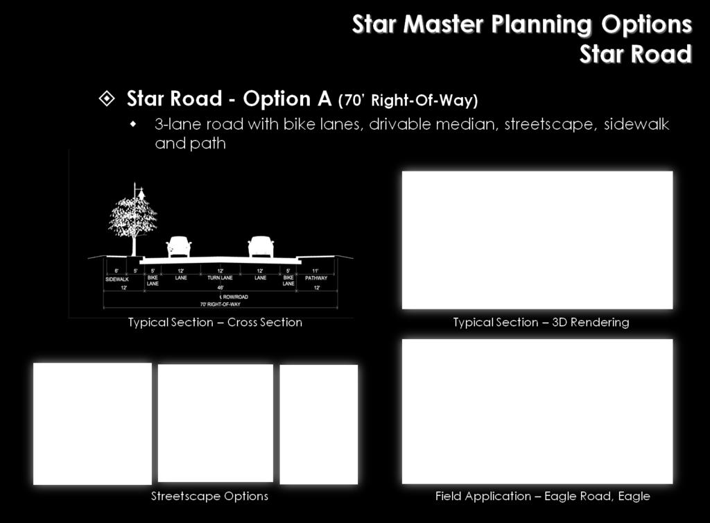
38 30 Figure 13

39 Parking The proposed streetscape improvements to State Street / Highway 44 and South Star Road will eliminate on-street parking to accommodate improved traffic flow and provide room within the existing right-of-way for bike lanes, wide sidewalks, landscaping and street furniture. Star s Comprehensive Plan includes the economic development objective, Provide on street parking in the CBD. 13 Ample off-street parking is currently offered to serve most of downtown Star s existing businesses. However, as Star s business density increases, off-street public parking areas will become increasingly important. Crosswalks Visible and frequent pedestrian crossing opportunities are a key aspect of creating a walk-able downtown core, especially when the primary commercial area is transected by a state highway. The City of Star is aware of this challenge and has recently worked with the Ada County Highway District to install a pedestrian-activated overhead flashing yellow light at Main Street and Highway 44. The primary objective of the project was to improve safety for pedestrians crossing State Street / Highway 44 in route to the Star River Walk and is a key element in creating pedestrian connectivity for areas north of State Street / Highway 44 to the Star River Walk. An eye-catching monument that defines a place can be as simple as this clock located in Meridian. Entryways Star lacks entryway signage or unique landscaping to provide visitors and residents with a sense of arrival and give them the impression that they are entering a community with a lot to offer. Increasing commercial development along State Street / Highway 44 to the west and east is reducing the rural aesthetic buffer between Star and its neighboring communities and making it more difficult to determine where Star s heart or core begins and ends. Establishment of entryway signage, public art and/or landscaping will complement the proposed streetscape improvements to help define Star s central core. Entryway elements do not need to be placed at city limits. Instead, locations should be chosen to maximize visibility and create a sense of arrival to the central core or downtown of a community. 13 Star Comprehensive Plan, pg

40 Gathering place Civic plazas and parks within a downtown area provide visitors and community members with a place to gather, recreate, enjoy events, and / or shop at outdoor market places. These central gathering places are important to downtown revitalization because they encourage prospective customers to stay longer in downtown and provide venues for events that can attract local and visiting customers. Several locations were identified as potentials for development of a civic plaza gathering place (see figure 14). Perhaps the best option for Star to develop a civic plaza would be to partner with a private business development to help finance, provide available property, and create compatible surrounding businesses. Generations Plaza in Meridian is a good example of a small-scale civic plaza development and was toured by Star residents during the downtown revitalization planning process. This picnic shelter at an Eagle park is an example of a flexible community gathering spot. 32

41 Figure 14 Star Downtown Master Plan ideas from January 2010 public workshop Please note: the graphic below captures the brainstormed ideas and vision of public workshop participants. Locations of items on the map are approximate and are not intended to represent final placement. STAR ROAD MAIN ST STATE ST. / SH44 Star Central Business District 33 Tree / Landscaping Bench / Seating area Public Art Plaza / Gathering Place location suggestion Street light N

42 Signage The signage displayed by businesses within a downtown core can either distract or enhance the appearance of the area. Star s businesses currently display a wide variety of signage, both permanent and temporary. A suggested standard for sign design should be provided to existing and new businesses. Interpretive signage design has recently been developed for the Star River Walk and would be a good foundation for broader community and business signage to reinforce a unified aesthetic and Star s connection to the Star River Walk. Funding help for signage upgrades can be incorporated into a business façade improvement grant program to encourage existing businesses to replace outdated or unsightly signs. Temporary signage such as sandwich boards and yard signs can add to signage clutter and distract from the ability of a downtown core to attract customers, yet businesses need to be given the opportunity to visually announce short-term specials and sales. Education about temporary signage options and resources for business owners can help raise the professional appearance and reduce the frequency of usage of temporary signs. Beautification Beautification is the act of making something more beautiful or the act of changing something into something different in essential characteristics. 14 In downtown revitalization efforts, beatification projects are generally small budget efforts implemented by community groups or volunteers in partnership with municipal leadership to improve the visual aspects of downtown. Star downtown planning participants identified the need for clean up, business façade improvements, and landscaping as top beatification priorities. Public workshop attendees often used this sign for Sully s Pub & Grill as an example of an attractive business sign. Clean up The level of basic cleanliness in a downtown reflects the extent of pride residents and business owners have in their community. Cleanliness includes weeding and mowing, junk removal, and reduction of clutter from public and private property and lots. Priority cleaning projects are identified in the project priority lists beginning on page Online dictionary by Farflex, accessed January 3,
43 Façade improvements Perhaps the best way to quickly improve the attractiveness of Star s downtown is to help property and business owners repaint and refurbish business fronts. With a little effort and minimal funds, big improvements can be made. Tim Reinders, of Main Street Iowa, in his Webinar presentation entitled Design on a Dime or The Power of Paint provided these benefits of a façade improvement program: Build Momentum for Revitalization: People can easily relate to a completed façade improvement. In most communities, there is not the immediate capacity to undertake large extensive (and costly) building rehabs. By getting some lower cost, highly visual projects completed, the program can begin to show results and create excitement and momentum for the revitalization efforts. Show Possibilities to the Community: Early in the life of a program, people have misperceptions about what is meant by using historic preservation as a development tool. Successfully implementing some high quality low cost highly visual projects helps show people that preservation does not have to be costly to be effective. Build Capacity in Community: People learn most by example. People also mimic or copy successful strategies they see others use. Successful projects build investor confidence, and also improve the skills and experience of contractors, bankers and investors. Expand pool of participants in improvements: For a variety of reasons, not every owner/business can implement a full scale total rehab. However, even some paint or some other low cost improvements can provide an opportunity for almost every building owner to participate in property improvements Main Street Innovation Lab Series, National Trust Main Street Center. 35

44 Businesses providing paint and paint supplies can often provide color consulting and design assistance at no cost to downtown business owners and offer discount prices on paint for downtown business façade improvement efforts. Landscaping Planter boxes and pots are an excellent way to quickly improve a downtown s appearance. Since they are not permanent fixtures, planting vessels can be added as a short-term fix to beautify an area while long-term streetscape infrastructure improvement projects are planned and funded. Landscaping is, in fact, a critical component of any successful development project and should be considered an essential part of the design process. - Star Comprehensive Plan, pg. 8-2 The construction, planting and maintenance of downtown planters, is also an excellent opportunity to involve the community in downtown revitalization efforts. Here are two examples: 1. The Ward 7 Arts Collective in Chicago offers an Adopt-a-box program where business owners adopt a planter box for the front of their business, then a mosaic artist works with area youth to make each box unique. 2. The all-volunteer Beautification Committee of Geneva, Illinois, involves the community in their downtown landscaping and planting box efforts by: - Throughout the year, local businesses help support the Beautification Committee by either adopting a planting area or donating supplies, plants and refreshments on group planting/clean-up days. - Volunteers or community groups can Adopt and maintain a planting bed. - Volunteers help with preparation, planting and clean-up of beds on designated days. - Other volunteers assist with various jobs, such as building flower boxes, delivering flowers and clean up plant debris or share their talents in areas, such as fundraising, promotion, taking photos and in the coordination of committee activities. - The community at large assists by participating in fundraisers to support the purchase of planters and plants. Fundraising efforts include sale of firewood bundles and a Pasta for Posies spaghetti dinner. 16 Youth arts project example: Adopt-abox project, Ward7 Arts Collaborative, Chicago Geneva Beautification Committee, Geneva, Illinois. 36

.")
45 Public art It is recommended that the City of Star take a deliberate approach to integrating the arts into the design of downtown redevelopment. The vision is to create a celebration of the arts that will bring cultural richness and economic support to the city center. During the planning process, regional artist Ward Hooper provided a presentation of design concepts for public artwork incorporating imagery using a star motif. Other motifs might be drawn from Star s agricultural heritage, proximity to the Boise River, or unique local wildlife (i.e. heron). A robust public art collection will incorporate multiple themes and motif, so Star should allow artists to pursue multiple motif concepts when developing public artworks. In addition to free standing sculptures or murals, public art can also be integrated into streetscape itself, transforming ordinary things like tree grates, fences or benches into unique functional artworks. Marketing via events and celebrations Events are a key marketing strategy to draw attendance and attention to downtown and its businesses. Downtown Rapid City, for example, has set a goal to have events and activities, targeted primarily to local residents, every day each year in a 365-day program held downtown so there is always something happening and the downtown area becomes the center of community activity. Star has a good start on reaching this goal; several events are offered throughout the year in, or near the city center. These include: Public art, like this piece in Boise s Basque Block, can be integrated into streetscape improvements Weekly live music at local venues like Sully s Pub & Grill (throughout the year) - Indoor and outdoor sporting events offered by Star s Parks and Recreation Department (throughout the year) - New Years eve party offered by a local business (January) - Senior Center Chili Feed (February) - Events at the Public Library (March, April, May) - Quilt Show (April) - Mother s Day Car Show (May) - Flea Market (summer months) - Outdoor movies (summer months) - Book Faire (September) - Hometown Celebration (September) Public art, like this piece by artist Ward Hooper, can help define a place while celebrating history.
METHODOLOGY - Scope of Work
 The scope of work for the Truckee West River Site Redevelopment Feasibility Study will be undertaken through a series of sequential steps or tasks and will comprise four major tasks as follows. TASK 1:
Draft CRA Plan Amendment. Community Redevelopment Agency Advisory Board September 23, CRA Plan Amendment
 Draft Community Redevelopment Agency Advisory Board September 23, 2013 1 Project Scope Feasibility Study Public Workshops/Stakeholder Interviews Market Study 2 Schedule to Date Feasibility Study Community
Objective 1. Research current housing issues in Avon to gain a deeper understanding of the housing market Type: Program Priority: 1 Cost: Medium
 Overall Comprehensive Plan Goals: Encourage growth in more suitable areas within town boundaries. These areas include sites close to existing residential, commercial, or industrial areas that are already
REQUEST FOR PROPOSALS
 REQUEST FOR PROPOSALS Downtown Triangle Redevelopment 1 st Street North, East Jackson Street, and Market Street City of Wisconsin Rapids 444 West Grand Avenue, Wisconsin Rapids, WI 54495 February 2017
Chapter 5 Planning for a Diversified Economy 5 1
 Chapter 5 Planning for a Diversified Economy Introduction The Planning for a Diversified Economy chapter will identify existing job opportunities in Prescott, strengths for attracting or retaining businesses
SMALL CITY PROGRAM. ocuments/forms/allitems.
 SMALL CITY PROGRAM The Small City Program provides Federal funds to small cities with populations from 5,000 to 24,999 that are NOT located within Metropolitan Planning Organizations' boundaries. Currently
GEORGETOWN DOWNTOWN DEVELOPMENT DISTRICT
 GEORGETOWN DOWNTOWN DEVELOPMENT DISTRICT Joint Workshop Town Council & Planning Commission 04/13/2016 INTRODUCTIONS PROJECT OVERVIEW PLANNING PROCESS DISTRICT BOUNDARY TODAY S AGENDA PLAN REVIEW NEXT STEPS
TRANSPORTATION FUNDING PROGRAMS
 APPENDIX A Note: Not yet edited by DCPD. TRANSPORTATION FUNDING PROGRAMS 6 Transportation Funding Programs The following provides a brief description of transportation related funding programs that are
Economic Development and Employment Element
 Economic Development and Employment Element Element Objectives The policies and actions of the Economic Development and Employment Element are intended to achieve the following nine objectives: 1. Provide
Anticipate future needs. Get the big stuff right (avoid paying 3x s-install, undo, re-install)
") City of Bowling Green Purpose Update on Land Use Plan It is the intention of the Bowling Green community to be a distinct family-friendly, college town comprised of a diverse community of residents, business
City of Bowling Green Purpose Update on Land Use Plan It is the intention of the Bowling Green community to be a distinct family-friendly, college town comprised of a diverse community of residents, business
CITY OF LA CENTER PUBLIC WORKS
 CITY OF LA CENTER PUBLIC WORKS TRAFFIC CALMING PROGRAM APPROVED PER RESOLUTION 08-304 ON DECEMBER 10, 2008 TABLE OF CONTENTS PAGE Summary... 1 Procedures... 2 Project Eligibility... 2 Project Funding &
2018 Regional Project Evaluation Criteria For PSRC s FHWA Funds
 2018 Regional Project Evaluation Criteria For PSRC s FHWA Funds INTRODUCTION As described in the adopted 2018 Policy Framework for PSRC s Federal Funds, the policy focus for the 2018 project selection
PLAN: Dudley Square June 2017 Planning Process Recap
 PLAN: Dudley Square June 2017 Planning Process Recap PLAN: Dudley is a community development plan which envisions the future of Dudley Square through the development of publicly-owned parcels. #3cba92
Economic Development Strategic Plan Executive Summary Delta County, CO. Prepared By:
 Economic Development Strategic Plan Executive Summary Delta County, CO Prepared By: 1 Introduction In 2015, Region 10, a 501(c)(3) Economic Development District that services six counties in western Colorado,
Town of Williamston Request for Proposals Mustang Alley Feasibility Study
 Town of Williamston Request for Proposals Mustang Alley Feasibility Study Project Name and Location Town of Williamston - Mustang Alley Feasibility Study Williamston, South Carolina Background Information
ECONOMIC DEVELOPMENT STRATEGIC PLAN. Adopted by the Riverbank City Council March 2011
 ECONOMIC DEVELOPMENT STRATEGIC PLAN Adopted by the Riverbank City Council March 2011 INTRODUCTION Economic development is a priority for Riverbank citizens and decision makers alike. The City wishes to
7/23/2013. Downtown Greenville s Success. Downtown Greenville s Success
 Downtown Greenville s Success What makes Greenville unique and successful? Community development Public space Partnerships Greenville s experience is not just about downtown Jumping off place to surrounding
POLY HIGH REDEVELOPMENT PROJECT AREA FIVE-YEAR IMPLEMENTATION PLAN
 POLY HIGH REDEVELOPMENT PROJECT AREA FIVE-YEAR IMPLEMENTATION PLAN Fiscal Year 2010 Fiscal Year 2014 (October 1, 2009 - September 30, 2014) CITY OF LONG BEACH REDEVELOPMENT AGENCY 333 West Ocean Boulevard,
PHASE 4 Deliberating. Drafting the plan and launching a vision.
 WELCOME. START HERE. WHAT IS FORWARD OP? WHAT IS A COMMUNITY-WIDE VISION? This process is an opportunity for the entire community to define what we want Overland Park to be in the future. It is based on
The Redevelopment Area could benefit from a public plaza, such as this one in southern California. CHAPTER IV: ACTION PLAN
 CHAPTER IV ACTION PLAN CHAPTER IV: ACTION PLAN This Action Plan represents a step in identifying and funding improvements in the Sonoma Valley elopment Project Area community. The Action Plan sets forth
Wolf River Conservancy in partnership with The City of Memphis Division of Park Services. Request for Proposals
 Wolf River Conservancy in partnership with The City of Memphis Division of Park Services Issued by Bob Wenner Wolf River Greenway Coordinator Wolf River Conservancy September 2, 2011 Proposal Deadline:
NORTH CENTRAL TEXAS COUNCIL OF GOVERNMENTS METROPOLITAN PLANNING ORGANIZATION REQUEST FOR PROPOSALS
 NORTH CENTRAL TEXAS COUNCIL OF GOVERNMENTS METROPOLITAN PLANNING ORGANIZATION REQUEST FOR PROPOSALS CITY OF CEDAR HILL CITY CENTER TRANSIT-ORIENTED DEVELOPMENT PLAN August 19, 2011 REQUEST FOR PROPOSALS
Appendix E: Grant Funding Sources
 Appendix E: Grant Funding Sources Federal Programs The majority of public funds for bicycle, pedestrian, and trails projects are derived through a core group of federal and state programs. Federal funding
Downtown Waukesha Façade, Sign and Awning Matching Grant Program
 Downtown Waukesha Façade, Sign and Awning Matching Grant Program City of Waukesha Community Development Department - 201 Delafield Street, Suite 200, Waukesha, WI 53188 262-524-3750 Program Highlights
Job Advertisement Executive Director Concord Downtown Development Corporation Issued February 5, 2018 Deadline to Respond: Friday, February 23, 2018
 Job Advertisement Executive Director Concord Downtown Development Corporation Issued February 5, 2018 Deadline to Respond: Friday, February 23, 2018 The Concord Downtown Development Corporation (CDDC)
Transportation Funding Terms and Acronyms Unraveling the Jargon
 Funding Terms and Acronyms Unraveling the Jargon Every profession has its own acronyms and jargon. The shorthand wording makes it easier and quicker for professionals in any given field to communicate
Transportation Alternatives Program Application For projects in the Tulsa Urbanized Area
 FFY 2015-2016 Transportation Alternatives Program Application For projects in the Tulsa Urbanized Area A Grant Program of Moving Ahead for Progress in the 21st Century (MAP-21) U.S. Department of Transportation
SILVERTHORNE COMPREHENSIVE PLAN APPENDIX A - ECONOMIC DEVELOPMENT ELEMENT
 SILVERTHORNE COMPREHENSIVE PLAN APPENDIX A - ECONOMIC DEVELOPMENT ELEMENT INTRODUCTION The ability to provide quality municipal services and infrastructure to the Silverthorne community is directly related
Neighborhood Revitalization. Fiscal Year 2017 State Revitalization Programs Application. DEADLINE FOR SUBMISSION: Friday, July 15, 2016 at 3:00 p.m.
 Maryland Department of Housing And Community Development LAWRENCE J. HOGAN Governor BOYD K. RUTHERFORD Lt. Governor KENNETH C. HOLT Secretary ELLINGTON CHURCHILL, JR. Deputy Secretary Division of Neighborhood
Distinctly Boerne! Boerne Master Plan ( ) JOINT MEETING OVERVIEW & PRIORITIZATION
 JOINT MEETING OVERVIEW & PRIORITIZATION") Distinctly Boerne! Boerne Master Plan (2018-2028) JOINT MEETING OVERVIEW & PRIORITIZATION Halff Staff Matt Bucchin, AICP, LEED-GA Director of Planning Josh Donaldson, AICP Planner / Landscape Designer
Distinctly Boerne! Boerne Master Plan (2018-2028) JOINT MEETING OVERVIEW & PRIORITIZATION Halff Staff Matt Bucchin, AICP, LEED-GA Director of Planning Josh Donaldson, AICP Planner / Landscape Designer
Dane County Comprehensive Plan Economic Development Goals & Objectives HED Work Group July 7, 2006
 Dane County Comprehensive Plan Economic Development Goals & Objectives HED Work Group July 7, 2006 Section I. Goal 1: Dane County will help to build and promote a robust, sustainable economy that enhances
Results of the Clatsop County Economic Development Survey
 Results of the Clatsop County Economic Development Survey Final Report for: Prepared for: Clatsop County Prepared by: Community Planning Workshop Community Service Center 1209 University of Oregon Eugene,
Honorable Mayor Shaw and Members of the City Council
 DATE: August 31, 2015 TO: FROM: Honorable Mayor Shaw and Members of the City Council Joanne Foust, Consulting Planner AGENDA ITEM: 6 A Outlet Center Feasibility Study Grant Opportunity ******************************************************************************
Local Economy Directions Paper
 Local Economy Directions Paper Official Community Plan Review - Phase 3 Help us refine our emerging directions! This paper provides a summary of what we have heard so far and a step towards developing
FIRST IMPRESSIONS COMMUNITY EXCHANGE TEAM MEMBER S GUIDE BOOKLET. Seeing things in a whole new light
 FIRST IMPRESSIONS COMMUNITY EXCHANGE TEAM MEMBER S GUIDE BOOKLET Seeing things in a whole new light Table of Contents Visiting Team Member Information... 1 Prior to Your Visit... 5 The Five Minute Impression...
Upper Darby Township 100 Garrett Rd. Upper Darby, PA 19082
 Upper Darby Township 100 Garrett Rd. Upper Darby, PA 19082 REQUEST FOR PROPOSAL BACKGROUND The Aronimink Station area is a mixed use neighborhood commercial area located at the intersection of Ferne Blvd.
U.S. Route 202 Analysis. New Castle County Department of Land Use May 4, 2018
 U.S. Route 202 Analysis New Castle County Department of Land Use May 4, 2018 Route 202 Study Area 202 Master Plan RFP 2018 Goal: Redevelop U.S. 202 as a high-quality and attractive multi-modal corridor
Long-Range Plan February 8, 2018 February 8, 2023
 100 Tinkham Lane Harrisville, Rhode Island 02830 http://www.jmslibrary.org Long-Range Plan February 8, 2018 February 8, 2023 Submitted February 2018 Mission Statement The primary mission of the Jesse Smith
Client: Boulder County Transportation Project: SH 119 Bus Rapid Transit & Bikeway Facility Design
 Client: Boulder County Transportation Project: SH 119 Bus Rapid Transit & Bikeway Facility Design I. Applicant (Client) Information Organization Name and Address Boulder County Transportation, 2525 13th
District of 100 Mile House. Business Façade Improvement Program Guidelines
 District of 100 Mile House Business Façade Improvement Program Guidelines - 2014 Business Façade Improvement Program Guide 2014 District of 100 Mile House Façade Improvement Program Guidelines Program
City of Nampa Strategic Plan. Adopted December 19, 2011
 City of Nampa Strategic Plan Adopted December 19, 2011 Content City leadership used a planning tool known as a Strengths Weaknesses Opportunities & Threats (SWOT) Analysis to assess City Government conditions,
2. Transportation Alternatives Program Activities Regulations and Guidelines... 4, 5 & Eligible and Ineligible Items...
 FY 2018 TRANSPORTATION ALTERNATIVES PROGRAM INSTRUCTIONS, GUIDELINES AND APPLICATION TABLE OF CONTENTS Page(s) 1. Instructions for Submitting a Transportation Alternatives Program Application.. 1 2. Transportation
Russell County Commission. Russell County, Alabama. Request for Proposal Comprehensive Plan Pages Notice of Intent to Respond
 Russell County Commission Russell County, Alabama Request for Proposal Comprehensive Plan Pages 1-15 Notice of Intent to Respond Request for Proposal Due: February 8, 2010 Table of Contents I. Project
New York Main Street Program & New York Main Street Technical Assistance RESOURCE GUIDE
 ANDREW M. CUOMO GOVERNOR DARRYL C. TOWNS COMMISSIONER/CEO New York Main Street Program & New York Main Street Technical Assistance RESOURCE GUIDE For more information about the New York Main Street (NYMS)
Major in FY2013/2014 (By and ing Source) Municipal Building Acquisition and Operations Balance $1,984, Contributions from Real Estate
 Municipal Building Acquisition and Operations Balance $1,984, Contributions from Real Estate") Major in FY2013/2014 (By and ing Source) Environmental Services Solid Waste 4200 4200 06CON 4200 SWM01 Balance $13,753,504.00 Balance $4,631,754.00 Balance $2,738,918.00 ing Source Total: $21,124,176.00
Major in FY2013/2014 (By and ing Source) Environmental Services Solid Waste 4200 4200 06CON 4200 SWM01 Balance $13,753,504.00 Balance $4,631,754.00 Balance $2,738,918.00 ing Source Total: $21,124,176.00
Request for Proposals City of Oberlin, Ohio Branding and Cultural Wayfinding Signage Plan
 Request for Proposals City of Oberlin, Ohio Branding and Cultural Wayfinding Signage Plan Introduction The City of Oberlin, Ohio, in association with the Firelands Association for the Visual Arts (FAVA),
Façade Improvement Program
 Policy Guidelines for the Façade Improvement Program Neighborhood Economic Development Entrepreneurs Discovering Opportunities Through Neighborhood Revitalization Community Development Department 2008
Request for Proposals # P12-044A. Pre-Qualification - Purchase and. Development of Bloomfield Property
 Request for Proposals # P12-044A Pre-Qualification - Purchase and Development of Bloomfield Property Bloomfield is a dynamic hub where community, cultural, social, and economic activities converge. Good
Coolidge - Florence Regional Transportation Plan
 Coolidge - Florence Regional Transportation Plan A Partnership Among the City of Coolidge, Town of Florence, and ADOT FINAL REPORT Kimley-Horn Kimley Kimley-Horn and and Associates, Associates, Inc. Inc.
Town of the Blue Mountains Community Improvement Plan
 Town of the Blue Mountains Community Improvement Plan Public Meeting Community Improvement Plan Thornbury February 14, 2011 Clarksburg Craigleith Topics Process Consultation Commercial Area Characteristics
Parks & Recreation Department Anchorage: Performance. Value. Results.
 Anchorage: Performance. Value. Results. Mission Provide for Healthy Parks, Healthy People, Healthy Future through ensuring Anchorage parks, facilities and programs are well maintained, safe, accessible
SOUTHWEST LRT (METRO GREEN LINE EXTENSION)
") 10 Joint Development This chapter describes potential long-term direct and indirect and short-term (construction) direct and indirect effects that would result from the Southwest Light Rail Transit (LRT)
10 Joint Development This chapter describes potential long-term direct and indirect and short-term (construction) direct and indirect effects that would result from the Southwest Light Rail Transit (LRT)
NORTHWEST SECTOR STUDY PHASE I REPORT. Approved 17 February 2015 (Resolution )
") EMBRACE ENHANCE EXPAND NORTHWEST SECTOR STUDY PHASE I REPORT Approved 17 February 2015 (Resolution 2015-02-022) This plan has been prepared by Parsons Brinckerhoff and their subconsultants for the City
EMBRACE ENHANCE EXPAND NORTHWEST SECTOR STUDY PHASE I REPORT Approved 17 February 2015 (Resolution 2015-02-022) This plan has been prepared by Parsons Brinckerhoff and their subconsultants for the City
US 50/SOUTH SHORE COMMUNITY REVITALIZATION PROJECT
 US 50/SOUTH SHORE COMMUNITY REVITALIZATION PROJECT ABOUT THE PROJECT Frequently Asked Questions What is the US 50/South Shore Community Revitalization Project? A transportation project along U.S. Highway
Exhibit B. Plumas County Non-Motorized Transportation Plan SCOPE OF WORK
 Exhibit B Plumas County Non-Motorized Transportation Plan SCOPE OF WORK PROJECT INTRODUCTION: The proposed project is the development of a legally compliant Plumas County Non- Motorized Transportation
City Plan Commission Work Session
 City Plan Commission Work Session February 5, 2013 Image Source Richardson Public Library 1 Agenda Project Introduction Vision for the Future Implementation Next Steps 2 Project Introduction 3 2009 Comprehensive
Transportation Demand Management Workshop Region of Peel. Stuart M. Anderson David Ungemah Joddie Gray July 11, 2003
 Transportation Demand Management Workshop Region of Peel Stuart M. Anderson David Ungemah Joddie Gray July 11, 2003 Why Transportation Demand Management (TDM)? Demand management measures support a sustainable
HEMPSTEAD LIVABLE CENTERS STUDY VALUES WORKSHOP
 HEMPSTEAD LIVABLE CENTERS STUDY VALUES WORKSHOP PARTNERS AGENDA Project Background Purpose of Livable Centers Study Approach and Process Expectations Review Goals for Livable Centers Study Opportunity
NEIGHBORHOOD BUILDING IMPROVEMENT PROGRAM
 SALT LAKE CITY NEIGHBORHOOD BUILDING IMPROVEMENT PROGRAM Now Targeting the Poplar Grove and Central Ninth Neighborhoods Program Guidelines SALT LAKE CITY Housing and Neighborhood Development (HAND) A Division
Summary of Focus Groups Lycoming County 2016 Comprehensive Plan Update April May 2016
 Summary of Focus Groups Lycoming County 2016 Comprehensive Plan Update April May 2016 Focus Group Overview As part of the 2016 Comprehensive Plan community outreach strategy, Lycoming County conducted
4. IMPLEMENTATION. 4.1 Implementation Matrix
 4. IMPLEMENTATION 4.1 Implementation Matrix IMPLEMENTATION MATRIX The Implementation Matrix includes the implementation items, proposed time line, potential participating parties and potential funding
Building our future, together. Steering Committee Presentation for the Comprehensive Plan Update November 12, 2013
 Building our future, together Steering Committee Presentation for the Comprehensive Plan Update November 12, 2013 Introduction Welcome: Mayor Barbara Bass Prayer Business and Economy Update Susan Guthrie,
Economic Development Element of the Arroyo Grande General Plan. Prepared by the City of Arroyo Grande Community Development Department
 Economic Development Element of the Arroyo Grande General Plan Prepared by the City of Arroyo Grande Community Development Department Adopted by City Council Resolution No. 4489 on October 9, 2012 Table
City of Palo Alto (ID # 4425) Planning & Transportation Commission Staff Report
 Planning & Transportation Commission Staff Report") City of Palo Alto (ID # 4425) Planning & Transportation Commission Staff Report Report Type: Meeting Date: 1/29/2014 Summary Title: Review of the Business and Economics Element of the Comprehensive Plan
City of Palo Alto (ID # 4425) Planning & Transportation Commission Staff Report Report Type: Meeting Date: 1/29/2014 Summary Title: Review of the Business and Economics Element of the Comprehensive Plan
Request for Proposal #15-07 Professional Engineering Services for Milwaukee Avenue Streetscape Improvements - Monroe Street to Greenwood Avenue
 VILLAGE OF NILES REQUEST FOR PROPOSAL Request for Proposal #15-07 Professional Engineering Services for Milwaukee Avenue Streetscape Improvements - Monroe Street to Greenwood Avenue RFQ Number: RFP# 15-07
St. Lucie County, Florida Land Development Code
 4.05.08 SRA Designation. St. Lucie County, Florida Land Development Code 4.05.08 Lands within the RLSA Overlay Zone may be designated as an SRA pursuant to the requirements of this section. A. Lands within
223 W Wisconsin Ave. P.O. Box 131 Tomahawk, WI Operating Plan For the Tomahawk Downtown Business Improvement District 2019
 223 W Wisconsin Ave. P.O. Box 131 Tomahawk, WI 54487 Operating Plan For the Tomahawk Downtown Business Improvement District 2019 Wisconsin Act 184 signed into law in 1984 gives Wisconsin municipalities
TRANSPORTATION ALTERNATIVES (TA) SET ASIDE PROGRAM July 2016
 SET ASIDE PROGRAM July 2016") Regional Transportation Commission TRANSPORTATION ALTERNATIVES (TA) SET ASIDE PROGRAM July 2016 Contents 1.0 Purpose and Eligibility... 2 2.0 Process... 5 3.0 Implementation of Funded Projects... 5 Attachment
Regional Transportation Commission TRANSPORTATION ALTERNATIVES (TA) SET ASIDE PROGRAM July 2016 Contents 1.0 Purpose and Eligibility... 2 2.0 Process... 5 3.0 Implementation of Funded Projects... 5 Attachment
Parks and Recreation Department Anchorage: Performance. Value. Results.
 Anchorage: Performance. Value. Results. Mission Provide for Healthy Parks, Healthy People, Healthy Future through ensuring Anchorage parks, facilities and programs are well maintained, safe, accessible
+! % / 0/ 1 2, 2 2, 3 1 ",, 4 +! % # ! 2, $
 Lakeland Vision is an independent, non-profit organization. It was formed in 1998 with the goal of creating and implementing a comprehensive, action-oriented vision for the future of the greater Lakeland
Telecommuting Patterns and Trends in the Pioneer Valley
 Telecommuting Patterns and Trends in the Pioneer Valley August 2011 Prepared under the direction of the Pioneer Valley Metropolitan Planning Organization Prepared by: Pioneer Valley Planning Commission
Comprehensive Plan 2009
 Comprehensive Plan 2009 2.14 PUBLIC SCHOOLS FACILITIES Goal: Coordinate and maintain a high quality education system. Collaborate and coordinate with the Okaloosa County School Board (School Board) to
REQUEST FOR PROPOSALS (RFP)
") REQUEST FOR PROPOSALS (RFP) TO: All Prospective Providers FROM: Kevin Keller, Planning and Development Director RE: Request for Proposals Town Green and Streetscape Improvements Consulting and Engineering
REQUEST FOR PROPOSALS (RFP) TO: All Prospective Providers FROM: Kevin Keller, Planning and Development Director RE: Request for Proposals Town Green and Streetscape Improvements Consulting and Engineering
Mr. George McNabb, Principal Paragon Real Estate 1400 Van Ness Avenue San Francisco, CA January 23, 2015
 95 Brady Street San Francisco, CA 94103 415 541 9001 info@sfhac.org www.sfhac.org Mr. George McNabb, Principal Paragon Real Estate 1400 Van Ness Avenue San Francisco, CA 94109 Ref: 1700 Market Street Mixed-Use
Lancaster County Smart Growth Transportation Program (Updated March 2017)
") Lancaster County Smart Growth Transportation Program (Updated March 2017) Program Description The Smart Growth Transportation (SGT) program was established offered by the Lancaster County Transportation
Lancaster County Smart Growth Transportation Program (Updated March 2017) Program Description The Smart Growth Transportation (SGT) program was established offered by the Lancaster County Transportation
California Main Street Four Point Approach
 California Main Street Four Point Approach California Main Street Structure Advisory Committee Program Manager Board of Directors Financial Funding Advocacy Policy Planning Personnel Broad based A Working
CONSOLIDATED PLAN AMENDMENT COMMUNITY DEVELOPMENT BLOCK GRANT PROGRAM CITY OF LEE S SUMMIT MISSOURI
 2006-07 CONSOLIDATED PLAN AMENDMENT COMMUNITY DEVELOPMENT BLOCK GRANT PROGRAM CITY OF LEE S SUMMIT MISSOURI May 11, 2006 1 PROGRAM OVERVIEW CDBG Entitlement Program Summary The Entitlement Status is a
PROGRAM GUIDE. ELIGIBLE APPLICANTS To be eligible to apply to the program:
 PROGRAM GUIDE PROGRAM PURPOSE AND GOAL The City of Williams Lake is pleased to provide the business façade improvement program with funding from Northern Development Initiative Trust. The purpose of the
FUNDING SOURCES. Appendix I. Funding Sources
 Appendix I. Funding Sources FUNDING SOURCES planning and related efforts can be funded through a variety of local, state, and federal sources. However, these revenues have many guidelines in terms of how
Wyoming Main Street Application Certified or Affiliate Levels (Letter of intent is due October 2, 2017) (Application is due December 1, 2017)
 (Application is due December 1, 2017)") Wyoming Main Street Application Certified or Affiliate Levels (Letter of intent is due October 2, 2017) (Application is due December 1, 2017) Submitted by: (Community) (Date) Wyoming Main Street Wyoming
Wyoming Main Street Application Certified or Affiliate Levels (Letter of intent is due October 2, 2017) (Application is due December 1, 2017) Submitted by: (Community) (Date) Wyoming Main Street Wyoming
A GROWTH PLAN FOR JENA, LOuISIANA Adopted JAnuAry 26, MAKING IT HAPPEN Making it Happen
 A growth plan for Jena, Louisiana Adopted January 26, 2010 6. MAKING IT HAPPEN 77 6. Making it Happen 78 6. MAKING IT HAPPEN Adopted January 26, 2010 A growth plan for Jena, Louisiana Priority Implementation
Comprehensive Planning Grant. Comprehensive Plan Checklist
 Comprehensive Planning Grant Comprehensive Plan Checklist This form was updated April 2010 Comprehensive Planning Grant Program Department of Administration Division of Intergovernmental Relations 101
Downtown Shoulder Area Community Improvement Plan. Investing in our Community
 Downtown Shoulder Area Community Improvement Plan Investing in our Community The Downtown Shoulder Area Renaissance Community Improvement Plan consists of the following: PART A - The preamble which does
Request for Proposals
 Request for Proposals Big Bethel AME Church Campus Development Strategy October 21, 2013 Big Bethel AME Church 220 Auburn Avenue NE Atlanta, Georgia 30303 Introduction Big Bethel AME Church and Bethel
South Dakota Transportation Alternatives
 South Dakota Transportation Alternatives Program Summary and Application Guide Updated March 2018 Connecting South Dakota and the Nation 1 Transportation Alternatives (TA) Summary 1. Overview Transportation
CITY OF DANA POINT AGENDA REPORT KYLE BUTTERWICK, DIRECTOR OF COMMUNITY DEVELOPMENT BRAD FOWLER, DIRECTOR OF PUBLIC WORKS DEPARTMENT
 01/17/12 Page 1 Item #14 CITY OF DANA POINT AGENDA REPORT Reviewed By: DH _X CM _X CA X DATE: JANUARY 17, 2012 TO: FROM: THE HONORABLE CITY COUNCIL KYLE BUTTERWICK, DIRECTOR OF COMMUNITY DEVELOPMENT BRAD
BUSINESS AND ECONOMICS
 This preliminary draft element was prepared by City staff on the basis of input from the CAC and members of the public received from January 2017 through February 2017. The Element will be reviewed by
CHAPTER 3: ECONOMIC DEVELOPMENT
 CHAPTER 3: ECONOMIC DEVELOPMENT GOAL 9: ECONOMY ECONOMIC DEVELOPMENT BACKGROUND SUMMARY INTRODUCTION This chapter addresses Statewide Planning Goal 9: "To provide adequate opportunities throughout the
City of Lansing Application #2 River Trail West (Near Elm St) - Wall and Pavement Repair
 - Wall and Pavement Repair") City of Lansing Application #2 River Trail West (Near Elm St) - Wall and Pavement Repair 1 2 Ingham County Parks and Recreation Commission P.O. Box 178 121 E. Maple Street, Suite 102 Mason, MI 48854 Trails
City of Lansing Application #2 River Trail West (Near Elm St) - Wall and Pavement Repair 1 2 Ingham County Parks and Recreation Commission P.O. Box 178 121 E. Maple Street, Suite 102 Mason, MI 48854 Trails
Economic Development Concept Plan
 Economic Development Concept Plan A. As the lead economic development organization, the Clay County Economic Development Commission (EDC) will enhance Clay County s capacity to engage in economic development
Economic Development Element
 Economic Development A. INTRODUCTION Purpose of the The overall purpose of the is to improve the local economy through diversification and integration with the regional economy. While the State Growth
APPENDIX METROFUTURE OVERVIEW OVERVIEW
 APPENDIX B METROFUTURE OVERVIEW OVERVIEW Land use decisions and many economic development decisions in Massachusetts are controlled directly by local municipalities through zoning. This planning is guided
634 NORTH PARK AVENUE
 Evaluation Criteria Submission Incentives, Districts & Zones Site Location Executive Summary Site Overview OPPORTUNITY FOR DEVELOPMENT 634 NORTH PARK AVENUE Warren, Ohio PREPARED BY: SITE OVERVIEW Address:
BUILDING MARKHAM S FUTURE TOGETHER. Summary of Public Engagement & Research
 Appendix B BUILDING MARKHAM S FUTURE TOGETHER Summary of Public Engagement & Research December 8, 2015 Table of Contents Purpose... 2 Executive Summary... 2 MetroQuest Public Engagement Tool... 4 Results...
REQUEST FOR PROPOSALS
 Community Development Department Planning & Zoning Division REQUEST FOR PROPOSALS COMBINED ACTIVE TRANSPORTATION/ SAFE ROUTES TO SCHOOL PLAN State Project No. ATPL-5169 (048) RELEASE DATE: SEPTEMBER 23,
MUNICIPALITY OF TRENT HILLS ECONOMIC DEVELOPMENT STRATEGIC PLAN
 1 MUNICIPALITY OF TRENT HILLS ECONOMIC DEVELOPMENT STRATEGIC PLAN 2010-2013 WWW.TRENTHILLS.CA INTRODUCTION The purpose of this document is to provide a guideline for taking actions that will strengthen
VALUE FOR SERVICE RESIDENTIAL PROPERTY TAX. Results for the Community
 VALUE FOR SERVICE RESIDENTIAL PROPERTY TAX 2017 Results for the Community Value for Service: Residential Property Tax The City of Fredericton prides itself on being a smart, sustainable city offering a
Attraction Development Grant Program Guidelines & Application
 Attraction Development Grant Program Guidelines & Application Mission: To assist the development of a critical mass of sustainable, market-driven travel experiences within the state that will influence
Oregon John A. Kitzhaber, M.D., Governor
 Oregon John A. Kitzhaber, M.D., Governor Department of Land Conservation and Development 635 Capitol Street NE, Suite 150 Salem, Oregon 97301-2540 Phone: (503) 373-0050 Fax: (503) 378-5518 www.oregon.gov/lcd
WAYFINDING SYSTEM DESIGN & BRANDING INITIATIVE
 CITY OF WAUPACA & WAUPACA AREA CONVENTION AND VISITORS BUREAU REQUEST FOR PROPOSALS WAYFINDING SYSTEM DESIGN & BRANDING INITIATIVE Date Issued: March 23, 2018 Proposals Due: April 20, 2018 by 4:00pm For