RECORD OF DECISION. Guam and CNMI Military Relocation
|
|
|
- Colleen Katrina Jackson
- 5 years ago
- Views:
Transcription
1 RECORD OF DECISION for Guam and CNMI Military Relocation including Relocating Marines from Okinawa Transient Nuclear Aircraft Carrier Berth Air and Missile Defense Task Force Department of the Navy and Department of the Army September 2010
2 TABLE OF CONTENTS SUMMARY... 1 SUPPLEMENTARY INFORMATION... 4 BACKGROUND... 7 PURPOSE AND NEED... 8 PUBLIC INVOLVEMENT ALTERNATIVES CONSIDERED ENVIRONMENTAL IMPACTS ADDITIONAL ENVIRONMENTAL CONSIDERATIONS BEST MANAGEMENT PRACTICES AND MITIGATION MEASURES SUMMARY OF DECISIONS AGENCY CONSULTATION AND COORDINATION RESPONSES TO COMMENTS ON THE FEIS OTHER RELAVENT CONSIDERATIONS ATTACHMENT 1 CIVIL-MILITARY COORDINATION COUNCIL INITIAL CHARTER... ATTACHMENT 2 DEVELOPMENT OF TRAINING RANGE ALTERNATIVES... ATTACHMENT 3 MITIGATION MEASURES... ATTACHMENT 4 TERRESTRIAL BO CONSERVATION MEASURES... ATTACHMENT 5 MARINE RESOURCES BO CONSERVATION MEASURES.. i
3 DEPARTMENT OF DEFENSE Department of the Navy Department of the Army (ROD) for the Guam and CNMI Military Relocation: Relocating Marines from Okinawa, Visiting Aircraft Carrier Berthing, and Air and Missile Defense Task Force AGENCY: Department of the Navy, Department of Defense Department of the Army, Department of Defense ACTION: Notice of SUMMARY: The Department of the Navy (DoN) and the Department of the Army (Army), after carefully weighing the environmental consequences of the proposed action, as well as considering operational and training requirements, strategic requirements, obligations under treaties and other international agreements, and cost, announce their decision to proceed with Guam and Commonwealth of Northern Mariana Islands (CNMI) Military Relocation. As a result of redefining the United States (US) defense posture in the Pacific region and the US alliance with Japan, a portion of US Marine Corps forces currently located in Okinawa, Japan will be relocated to Guam. This relocation of Marine Corps forces will meet international agreement and treaty requirements and fulfill US national security policy requirements to provide mutual defense, deter aggression, and dissuade coercion in the Western Pacific Region in response to the evolving security environment in the Pacific region, as identified through the Integrated Global Presence and Basing Strategy and the Quadrennial Defense Review (QDR). The redefining of the US defense posture in the Pacific also calls for greater availability of aircraft carrier strike groups in the Pacific to support engagement, presence, and deterrence. Finally, in support of the proposed military relocation, the stationing of an Air and Missile Defense Task Force (AMDTF) is also being considered. A significant number of countries have ballistic missile capabilities which can deliver conventional, nuclear, biological, and chemical weapons. Other countries are working to establish these capabilities and missile systems. The effective strike range of defensive ballistic missile systems dictates that they must be located in the proximity of the protected assets. The need for the proposed AMDTF is to protect the territory of Guam, its citizens, U.S. and allied forces on Guam from the threat of harm from ballistic missile attacks from other countries and enemies of the US. Implementing the military relocation analyzed in the Environmental Impact Statement (EIS) will be a multi-agency, multi-year effort undertaken by the DoN, Army, Department of 1
4 Transportation s Federal Highway Administration (FHWA), Guam utilities, Guam agencies, and various private entities. Implementation includes several components: (1) Marine Corps: (a) Development and construction of facilities and infrastructure to support approximately 8,600 Marines and their 9,000 dependents being relocated from Okinawa to Guam. (b) Development and construction of facilities and infrastructure to support training and operations on Guam and Tinian; DoN has elected to defer selection of a specific site for the construction and operation of a live fire training range complex in the Route 15 area on Guam pending completion of the Section 106 consultation process under the National Historic Preservation Act (NHPA). Likewise, a selection regarding implementation of a roadway improvement project calling for a realignment of Route 15 is hereby deferred pending selection of a specific site for the construction. (2) Navy: Construction of a new deep-draft wharf with shoreside infrastructure improvements creating the capability in Apra Harbor, Guam to support a transient nuclear powered aircraft carrier; DoN has elected to defer selection of a specific site for the construction and operation of a transient aircraft carrier berth within Apra Harbor for the near term. However, the analysis presented in the FEIS, including the marine resources impacts analysis, provides sufficient information to allow the DoN to fully consider the direct, indirect and cumulative environmental impacts of locating a transient aircraft carrier berth and make a programmatic decision to locate a transient aircraft carrier berth generally within Apra Harbor, which is the only deep draft harbor on the island of Guam that could support such a berth. (3) Army: Development of facilities and infrastructure on Guam to support relocating approximately 600 military personnel and their 900 dependents to establish and operate an Air and Missile Defense Task Force (AMDTF). As of the date of this ROD, the DoD has not decided to construct and operate an AMDTF on Guam. The decision on whether to assign this mission to the Army will be made pending the results of the ongoing regional and global Ballistic Missile Defense architectural and capability studies. It will also be based in part on the EIS for this proposed action with Guam as one site that is under consideration for an AMDTF mission. The FEIS was prepared noting that if the mission were assigned to Army, the alternatives presented in the FEIS represent how Army could implement the action on Guam. Army has selected the preferred alternatives described in Volume 5 of the FEIS as the appropriate manner to implement the proposed action if and when the mission is assigned. (4) Utilities: Renovation and development of additional capacity for power, water, and wastewater systems, both on base and off base, to support the increased demand from the new 2
5 Marine Corps Base and associated growth in DoD and civilian population caused by the Relocation. (5) Off-base Roadways: Improvements to off base roads, bridges, and intersections to support increased traffic and offset significant impacts caused by the Relocation. Each of the major actions noted above encompasses several construction projects to provide required facilities and infrastructure. Most of the major actions and their supporting projects have alternative sites located throughout the island of Guam. This ROD will document and demonstrate why DoD has chosen to implement the preferred alternatives for each of the actions described in the FEIS except as noted above. Because DoN and Army are preparing this ROD as a joint effort, both concur and support the decisions expressed within it. The ROD includes descriptions and discussions of the proposed actions and their impacts. It also includes descriptions and discussions of all related actions and their impacts. Combined, these two elements - proposed and related actions, with associated impacts - provide the context for consideration of the collective and cumulative impacts associated with all actions addressed in the FEIS. While this ROD represents the decisions of DoN and Army regarding the proposed actions, federal agencies have greatly contributed to formulating and refining the approach to implementing actions and associated mitigation measures. Led by CEQ-facilitated discussions, DoD reached major agreements with various federal regulatory agencies regarding key issues, refined action alternatives for Guam s potable water and wastewater systems, committed to the use of force flow reduction and Adaptive Program Management (APM) as mitigation measures, and established a Civil-Military Coordination Council (CMCC) to implement APM. All of these actions are discussed with greater detail within the ROD. DoN would like to recognize the efforts of CEQ, the US Environmental Protection Agency, the Department of Interior, the National Oceanographic and Atmospheric Administration, and the Government of Guam Agencies and thank them for their participation and assistance in seeking resolution to the many challenges confronting DoD in the completion of the NEPA process for this proposed action. It is also recognized that as the military construction projects necessary to implement the actions move forward, each of these agencies will have a continuing role through either a regulatory, permitting, or advisory capacity and will continue to be partner in the implementation of the actions. This ROD was prepared in accordance with Council on Environmental Quality (CEQ) Regulations for Implementing the Procedural Provisions of NEPA 40 CFR parts 1500 to 1508 and specifically, 40 CFR Record of decision in cases requiring environmental impact statements. 3
6 FOR FURTHER INFORMATION CONTACT: Mr. Darrell Molzan, Environmental Director, Joint Guam Program Office, Office of the Assistant Secretary of the Navy (Energy, Installations and Environment), 1000 Navy Pentagon, Washington, DC, SUPPLEMENTARY INFORMATION: Pursuant to 42 U.S.C et seq. (Section 101 et seq. of NEPA); the regulations of the President s Council on Environmental Quality (CEQ) that implement NEPA procedures (40 CFR Parts ); Department of Defense (DoD) Instruction , Environmental Planning and Analysis; and applicable DoN environmental regulations and instructions that implement these laws and regulations, the DoN announces its decision to relocate U.S. Marines Corps forces from Okinawa, Japan to Guam, construct the infrastructure to support this relocation effort, and conduct training and operations on Guam and Tinian with the relocated Marine Corps forces. Additionally, the Navy announces its decision to construct and operate a berth for a transient nuclear aircraft carrier in Guam. The Army announces its decision regarding construction and operation of AMDTF facilities on Guam if tasked in the future with the mission of providing ballistic missile defense for Guam. Additionally, DoN announces it decision regarding the preferred solutions for roadway and utility system improvements on Guam to support the military buildup. To implement the actions necessary for relocating U.S. Marine Corps forces from Okinawa to Guam, the DoN has decided to select all of the preferred alternatives described in Volumes 2, 3 and 6 of the FEIS and to implement all mitigation measures noted in this ROD, except as noted below. Relative to Volume 2 and the construction and operation of facilities on Guam, the major actions and decisions include the following: (1) For a main cantonment area DoN selects Alternative 2. Implementation of this alternative would involve utilizing DoDowned lands at NCTS Finegayan and South Finegayan Navy Housing and acquiring non-dodowned land known as the former FAA parcel. (2) For access to the Naval Munitions Site (NMS) DoN selects Alternative B, which involves the use of the existing hiking trail as the access road. (3) For the location of additional ammunition storage at NMS DoN selects Alternative A, the use of Parson s Road. (4) For airfield functions DoN selects the following actions: beddown of the Marine Corps Air Combat Element (ACE) and construction of associated facilities at Andersen AFB North Ramp, construction of air embarkation facilities at Andersen AFB South Ramp, and construction of the North Gate and access road at Andersen AFB. 5) For Marine Corps embarkation facilities DoN selects to refurbish various wharfs and upgrade utilities to support waterfront functions and operations at Naval Base Guam, associated dredging and dredge disposal management (with a priority for beneficial reuse of dredge material), relocation of military working dog kennels at Naval Base Guam, and construction of a medical/dental clinic at Naval Base Guam. Relative to the construction and operation of a live-fire training range complex on Guam, DoN has elected to defer selection of a specific site in the Route 15 area pending completion of the Section 106 consultation process under the National Historic Preservation Act (NHPA). 4
7 Alternative A remains DoN s preferred alternative. Upon completion of the Section 106 consultation process, should DoN select this alternative it would involve the acquisition of approximately 1,090 acres of non-dod owned lands on a plateau across from Andersen AFB South along Route 15. Relative to Volume 3 and actions on Tinian, DoN selects Alternative 1, which will involve the construction and operation of Known Distance (KD) rifle, Pistol/MP, Platoon, and Field live fire training ranges on north/northeast, north, or northeast alignments respectively. Relative to Volume 6 and solutions to meet required utilities improvements necessary to support the military build-up on Guam: (1) For power DoN selects solutions that will include reconditioning up to five (5) existing GPA combustion turbine (CT) power generation units. Additionally, the power solution will involve power transmission and distribution line upgrades to provide the appropriate level of reliability to serve military needs at Apra Harbor, NCTS Finegayan, and Andersen AFB. (2) For potable water DoN selects solutions that will include the provision of an additional potable water capacity of 11.3 million gallons per day (MGd) through the establishment of up to 22 new DoD water wells at Andersen AFB, rehabilitation of existing wells, interconnects with the GWA water system, and construction of associated treatment, storage and transmission systems. (3) For wastewater DoN selects solutions that will include repairs and upgrades to primary treatment capabilities at the Northern District Waste Water Treatment Plant (NDWWTP), improvements to the NDWWTP to achieve secondary treatment standards and expansion of the plant beyond the current design capacity of 12 MGd, improvements to the Northern and Central wastewater collection systems, and improvements to the Hagåtña WWTP to achieve secondary treatment standards. (4) For solid waste DoN selects solutions that will continue the use of existing Navy Apra Harbor landfill until the new GovGuam public landfill at Layon is completed. Relative to Volume 6 and roadway improvements DoN selects Alternative 2, Limited Roadway Improvements, which involves a limited number of off-base roadway and intersection improvement projects that have received DAR certification or that have been deemed DAReligible. These projects include roadway widening, intersection improvements, bridge replacements, pavement strengthening at specific locations island-wide, and military access points as well as the realignment of a portion of Route 15. Based on the level of concern expressed in comments on the Draft EIS, continued discussions with cooperating agencies under NEPA, and the DoN s continuing commitment to environmental stewardship, the DoN has elected to defer selection of a specific site for the construction and operation of a transient aircraft carrier berth within Apra Harbor for the near term. However, the analysis presented in the FEIS, including the marine resources impacts analysis, provides sufficient information to allow the DoN to fully consider the direct, indirect and cumulative environmental impacts of locating a transient aircraft carrier berth and make a programmatic decision to locate a transient aircraft carrier berth generally within Apra Harbor, which is the only deep draft harbor on the island of Guam that could support such a berth. 5
8 Discussions with the Environmental Protection Agency (EPA), National Oceanic and Atmospheric Administration (NOAA), and the Department of Interior (DOI) identified additional data these agencies would prefer were available for use in analyzing specific sites for placement of the transient nuclear aircraft carrier wharf. The Navy will voluntarily collect additional data on marine resources in Apra Harbor at the alternative transient aircraft carrier berth sites still under consideration by the Navy as set out in Volume 4 of the FEIS. The type and scope of the additional data to be collected has been developed cooperatively with EPA, NOAA, and DOI and is described in the Final Scope of Work Elements for Marine Surveys of the CVN Transient Berth Project Area, Potential Mitigation sites, and Habitat Equivalency Analysis included in Volume 9, Appendix J of the FEIS. The additional data collected, associated analysis, and any other data that may be required by the United States Army Corps of Engineers (USACE) during the Clean Water Act (CWA) permitting process, will be used in the future to inform the subsequent selection of a specific site for the transient aircraft carrier berth and to support any future CWA permitting decisions for the selected site, including compensatory mitigation. As of the signatory date of this ROD, the DoD has not decided to assign this mission to the Army nor to construct and operate an AMDTF on Guam. The decision on whether to assign this mission to the Army, and subsequently construct and operate an AMDTF on Guam, will be made pending the results of the ongoing regional and global Ballistic Missile Defense architectural and capability studies. Guam is one site that is under consideration for an AMDTF mission. The FEIS was prepared noting that if the mission were assigned to Army, the alternatives presented in the FEIS best represent how Army will implement the action on Guam. Army has selected the preferred alternatives described within Volume 5 of the FEIS as the appropriate and desired manner to implement the proposed action if and when the mission is assigned. 6
9 BACKGROUND The FEIS addressed proposed actions involving the Marine Corps, the Navy and the Army. Given their temporal and geographic proximity, these cumulative actions were addressed in the same FEIS in order to best assess their potentially cumulative significant impacts. Each is based upon distinct and specific strategic and national security objectives and could proceed on its own. Thus, each action has independent utility. The FEIS consists of several volumes to further display the independent utility of the various proposed actions and provide an analysis of impacts directly associated with those actions and their alternatives. DoD has developed a range of alternatives for each of the proposed actions. Within each volume, a resource related analysis was provided. Related actions common to each of the major actions, such as utilities and roadways are covered under a separate volume, Volume 6. Further, to ensure the collective impact of the proposed actions was captured, a separate volume, Volume 7, was created to look at the summation of impacts and the cumulative impacts. Cooperating Agencies included the FAA, FHWA, Department of Agriculture, U.S. Air Force, USACE, U.S. EPA Region 9, and U.S. Department of Interior, Office of Insular Affairs. The focus of the underlying EIS, as with all documents prepared under NEPA, is the impacts of the proposed action upon the environment. Thus, the DEIS, FEIS, and this ROD evaluated the impacts of the proposed military build-up actions upon the natural and physical environment of Guam and Tinian. Only to the extent that natural and physical impacts associated with the proposed actions are interrelated with social or economic effects are the social and economic effects discussed. Therefore, the analysis and discussion presented in the DEIS, FEIS, and ROD must be viewed through the prism of environmental impacts, not social or economic impacts. 7
10 PURPOSE AND NEED As a result of efforts to redefine the United States (U.S.) defense posture in the Pacific region and the U.S. alliance with Japan, a portion of U.S. Marine Corps forces currently located in Okinawa, Japan will be relocated to Guam. The overarching purpose of the proposed actions is to locate U.S. military forces to meet international agreement and treaty requirements and to fulfill U.S. national security policy requirements to provide mutual defense, deter aggression, and dissuade coercion in the Western Pacific Region. The proposed actions will meet the following criteria based on U.S. policy, international agreements, and treaties: Position U.S. forces to defend the homeland including the U.S. Pacific territories Locate U.S. forces within a timely response range Maintain regional stability, peace and security Maintain flexibility to respond to regional threats Provide a powerful U.S. presence in the Pacific region Increase aircraft carrier presence in the Western Pacific Defend U.S., Japan, and other allies interests Provide capabilities that enhance mobility to meet contingencies around the world Have a strong local command and control structure Protect the territory of Guam and the U.S. forces and allies on Guam from all classes and ranges of air and ballistic missile threats. From a global strategic perspective, the U.S. maintains military capabilities in the Western Pacific to support U.S. and regional security, economic and political interests, and to fulfill treaty and alliance agreements. The Guam and CNMI Military Relocation program proposes distinct, yet related actions to support this position. The actions are the relocation of Marine Corps forces from Okinawa to Guam, Marine Corps training activities on Tinian, construction and operation of a Navy transient nuclear aircraft carrier wharf in Guam, and establishment and operation of an AMDTF on Guam. In addition, roadway and utility improvements are necessary to support the previously listed actions. Each component has an independent purpose and an independent utility. Likewise, the decisions on each component are independent of the others. A. Relocation of Marines to Guam: In response to the evolving security environment in the Pacific region, the Integrated Global Presence and Basing Strategy (IGPBS) and Quadrennial Defense Review (QDR) initiatives began to focus on posture changes in the Pacific region. These initiatives included reduction of overseas forces while striving to base forces in locations that support flexibility and speed of response to anywhere in an unpredictable 8
11 environment. Based on the QDR recommendations for global repositioning and operational realignments in the Pacific Region, the DoD began to identify suitable locations to relocate a portion of Marine Corps forces on Okinawa that met: (1) treaty and alliance requirements; (2) response times to potential areas of conflict; and (3) freedom of action (use of base without restrictions). In a parallel initiative with the IGPBS, beginning in December 2002 the US engaged the GoJ in discussions regarding coordination of changes in U.S. force posture in Japan and the options to optimize those changes with other force realignments in the Pacific. Over a three and one-half-hear period, a series of sustained security consultations under the auspices of the U.S.- Japan Security Consultative Committee (SCC) was conducted. These talks, which came to be known as the Defense Policy Review Initiative (DPRI), were aimed at evolving the U.S.-Japan Security Alliance to reflect today s rapidly changing global security environment. DPRI focused on alliance transformation at the strategic and operational levels, with particular attention to the posture of US and Japanese forces in Japan, as well as transforming capabilities in the Western Pacific. These discussions and negotiations resulted in an agreement known as the Alliance Transformation and Realignment Agreement (ATARA). The ATARA and the U.S.-Japan Roadmap for Realignment Implementation, known as the Roadmap Agreement require relocating approximately 8,000 Marine personnel and 9,000 dependents from Okinawa to Guam, placing forces on the furthest forward element of sovereign U.S. territory in the Pacific capable of supporting such a presence, thereby maximizing their freedom of action while minimizing the increase in response time relative to their previous stationing in Okinawa. Under the ATARA and Roadmap Agreement, Japan has agreed to a cost-sharing arrangement with the U.S. that would provide funding of up to $6.09 billion (in US 2008 dollars) to support the relocation of the Marine Corps forces from Okinawa to Guam. This cost-sharing arrangement includes GoJ provided financing for up to $740 million of required utilities improvements to support the Marine Corps realignment effort. The utilities improvements will be accomplished either by Special Purpose Entities (SPEs), which would likely be private business entities formed to finance, operate, manage, upgrade, or develop utility systems and associated infrastructure, or by Guam utilities themselves. B. Training on Tinian: Training operations on Tinian would support up to company-level sustainment training for Marine Corps forces on Guam. (See Attachment 2 for a description of the Marine Corps training continuum). This training, which is a higher level of training than the individual skills level training conducted on Guam, is essential to the end-state of sustaining combat readiness Marine Corps personnel on Guam. Because Guam cannot accommodate all training for the relocating Marine Corps forces, Tinian, which is approximately 100 miles away and has greater land availability, provides the best opportunities for training groups of 200 Marines or larger, the next step of the training continuum. Currently the northern two-thirds of Tinian is leased to DoD. Company and battalion level non-live fire trainings areas 9
12 already exist and are utilized on these leased Tinian parcels. These leased parcels would be developed to accommodate limited live fire training ranges capable of handling small unit combat skills training. Due to physical size and layout constraints, as well as existing structures, natural resources and sensitive cultural resources, the training areas on Tinian cannot support both individual and small unit combat skills training and their associated ranges. Further, the use of ranges on Tinian will be as an expeditionary setting, operating on a largely self sustaining basis with very little infrastructure and support staff. Such a set-up could not support the needs of individual combat skills training given its greater frequency and volume of usage. Thus, those ranges must be placed on Guam. C. Development of a Navy Transient Aircraft Capability in Guam: The 2006 QDR states that the U.S. realignment strategy has a need for greater availability of aircraft carrier strike groups in the Pacific to support engagement, presence, and deterrence, supplementing current ship deployments, port visits in the region, and the aircraft carrier base (homeport) in Japan. Port visits are generally of short duration with limited availability for maintenance support. In contrast, a transient capable wharf has greater support for vessel maintenance and crew quality of life, enabling longer stays in a region. Based upon the QDR and treaty and alliance requirements, DoD began to identify suitable locations for a new transient nuclear carrier wharf in the Pacific that met: (1) treaty and alliance requirements; (2) response times to potential areas of conflict; and (3) freedom of action (use of a base without restrictions, including implementation of force protection measures to deter/avoid terrorist attacks). The QDR posits that the U.S. should strive to position forces in locations that support flexibility and speed of response to anywhere in an unpredictable environment. The proposed action to create a transient nuclear aircraft carrier wharf in Guam meets all of these requirements. D. Development of an AMDTF: A significant number of countries have ballistic missile capabilities which can deliver conventional, nuclear, biological, and chemical weapons. Other countries are working to establish these capabilities and missile systems. The effective strike range of defensive ballistic missile systems dictates that they must be located in the proximity of the protected assets. The need for the proposed AMDTF to be placed on Guam would be to defend territories, citizens, and forces of the U.S. and its allies on Guam against all classes and ranges of air and ballistic missile threats. Its defensive umbrella will ensure that local military assets are protected and remain available to meet their military missions. New and/or upgraded infrastructure and facilities will be developed as described in the preferred alternatives section of the FEIS Volume 5 that will support the presence and operation of an AMDTF land-based air defense capability on Guam. E. Utilities: The proposed military relocation on Guam will increase the demand for power, potable water, and wastewater utilities. The military relocation will also affect the remaining life of existing solid waste facilities and the demand for the new Government of Guam (GovGuam) Layon Landfill in Dandan. The purpose of the proposed utility actions is to satisfy the utility requirements of the relocating military forces and the associated demands imposed by 10
13 indirect and induced effects of population growth on Guam caused by the military relocation effort. F. Guam Roadway Network (GRN) Improvements: The purpose of the proposed GRN actions is to improve the existing Guam roadway network through the DAR program, or other funds, to provide mission-critical transportation infrastructure improvements necessary for the planned military relocation. The improvements proposed for the GRN will result in strengthened roadways, bridge replacements, increased roadway capacity, new access, and enhanced roadway safety on Guam to accommodate increased construction traffic caused by the military relocation and subsequent induced growth. 11
14 PUBLIC INVOLVEMENT A. Public Scoping: A Notice of Intent to prepare an EIS/OEIS was published in the Federal Register on March 7, 2007 (72 Fed. Reg ), and public scoping meetings were held on April 17 and 18, 2007 on Guam, and April 19 and 20, 2007 on Saipan and Tinian, respectively. Approximately 130 notices regarding the public scoping period were mailed on March 24, 2007 to elected officials, federal, state, and local government agencies, nongovernmental organization representatives, and other entities possibly interested in the EIS/OEIS. The scoping period was scheduled to end on May 1, However, DoN extended the scoping period deadline to May 21, 2007 due to the impacts of Typhoon Kong-Rey. During the scoping period, the public provided comments on a variety of important topics such as access to DoD facilities, social and environmental effects, economics, Chamorro interests, safety, infrastructure, and transportation. All topics identified during the scoping period were considered in the development of the scope of the environmental impact analyses. Approximately 990 scoping comments were received. B. DEIS Public Comment/Hearings: The public comment period for the Draft EIS initiated with the publication of a combined Notice of Availability (NOA)/Notice of Public Hearing (NOPH) in the Federal Register on November 20, 2010 (74 Fed. Reg ). The notice announced the availability of the Draft EIS and time, dates, and locations of public hearings. The notice also gave an overview of the proposed actions and potential environmental impacts as presented in the Draft EIS. EPA published a separate NOA of the Draft EIS on November 20, 2010 (74 Fed. Reg ) that contained an erroneous date for the conclusion of the public comment period. EPA published a notice in the Federal Register on November 27, 2009 (74 Fed. Reg ) with the correct end date for the public comment period of February 17, The DEIS was made available to the public via several sources. Copies of the printed DEIS were placed in five public libraries throughout Guam, Saipan, and Tinian. Copies of the DEIS were also provided to various government offices and the elected officials on the same three islands and made available electronically via a publicly accessible web-site. Post card notification announcing the DEIS availability was mailed to those who elected to receive it. During the public comment period, six public hearings were held. Four of the hearings took place on Guam (January 7, 9, 11, and 12, 2010), one on Tinian (January 14, 2010), and one on Saipan (January 15, 2010). An estimated total of 1,977 people attended the hearings. Each of the public hearings had a similar format with an open house during the first two hours followed by a two-hour formal public hearing. Informational posters were displayed and DoD subject matter experts were available during the open house portion of the hearing to answer questions on the DEIS. Written comments were received from the general public, government agencies, and interest groups via mail, web-site submittal, and written comments submitted at the public hearings. Additionally, oral comments were received at the public hearings. 12
15 For more detailed information on comments received on the Draft EIS see Volume 1 and Volume 10 of the FEIS. C. FEIS Public Notice of Availability: The 30-day wait/review period for the FEIS was initiated with the publication of the NOA in the Federal Register on July 28, 2010 (75 Fed. Reg ). The notice announced the availability of the FEIS. The notice also gave an overview of the proposed actions, and potential environmental impacts as presented in the abstract of the FEIS. The FEIS was made available to the public via several sources. Copies of the printed FEIS were placed in five public libraries throughout Guam, Saipan, and Tinian. Copies of the FEIS were also provided to various government offices and the elected officials on the same three islands and made available electronically via a publicly accessible web-site. Post card notification announcing the FEIS availability was mailed to those who elected to receive it. The DoN extended the wait/review period by 14 days to September 3, 2010, which allowed the public additional time to review the FEIS and DoN and Army decision makers more time to fully consider all aspects and impacts of the proposed actions. 13
16 ALTERNATIVES CONSIDERED Volumes Two through Five of the EIS provide a description and analysis of each specific action included under the umbrella of the Guam and CNMI Military Relocation. Within each of these volumes, actions are further divided with alternatives considered for each proposed action. Volume Six of the EIS provides alternatives to roadways and utilities for Guam. The discussion of alternatives considered herein follows that format and focuses solely on alternatives presented for analysis in the FEIS. Attachment 2 to this ROD provides a more in-depth discussion of the history and resultant alternatives development process for the proposed live-fire training ranges on Guam. Regulations implementing NEPA require the identification of the environmentally preferred alternative. Therefore, each of the alternative discussions below includes identification of the environmentally preferred alternative. All environmentally preferred alternative discussions focus only on proposed action alternatives as it is understood that the no-action alternatives would result in lesser environmental impacts, but would not meet the purpose and need of the proposed action. A. USMC Relocation to Guam: Four functional components were identified, with alternative sites developed for each: Main Cantonment Area, Training, Airfield, and Waterfront. 1. Main Cantonment Area: Main Cantonment military support functions include headquarters and administrative support, bachelor housing, family housing, supply, maintenance, open storage, community support, some site-specific training functions, and open space. Eight Main Cantonment alternatives were initially developed and evaluated; however, alternatives 4 through 7 were dismissed from further consideration within the EIS because they did not satisfy the screening criteria established. A qualitative assessment of the feasibility of the eight main cantonment alternatives was completed utilizing the following criteria: environmental considerations, anticipated public concerns, and service. Alternative 4 did not meet the environmental criteria because it had an overwhelming impact on areas of essential habitat. Alternative 5 did not meet public or the service criteria because of adverse impacts to recreational beach and ocean uses, the separation of live-fire training ranges, and the separation of live fire training ranges from the adjacent non-firing training. The latter two elements did not support combat readiness because of operational inefficiencies. Alternative 6 was eliminated because the complexity of land acquisition, which would have likely required more than ten years and thus not allowed the Marine Corps relocation to occur in a timely manner.. Alternative 7 did not meet the service criteria because the separation of the live fire training range complex from the non-fire training led to operational inefficiencies that adversely affected combat readiness. The remaining four alternatives (1, 2, 3, and 8) were retained in the EIS for further analysis and are discussed below. a. Alternative 1: Alternative 1 includes Naval Computer Telecommunications Station (NCTS) Finegayan (1,090 acres [ac] hectares {ha}), South 14
17 Finegayan (290 ac [117 ha]), acquisition of the former Federal Aviation Administration (FAA) parcel (680 ac [275 ha]), and acquisition of Harmon Annex (328 ac [133 ha]), for a total of 2,388 ac [966 ha]. Of the total Overlay Refuge (2,095 ac [848 ha]) in the Finegayan area, this alternative will develop approximately 29% (599 ac [242 ha]). The Overlay Refuge is managed pursuant to a Memorandum of Agreement with the United States Fish and Wildlife Service (USFWS). Overlay Refuge refers to specific areas on Guam that were established for protection of endangered and threatened species and other native flora and fauna, maintenance of native ecosystems, and the conservation of native biological diversity. These areas were established in cooperation with Guam Department of Agriculture Division of Aquatic and Wildlife Resources (DAWR) and are managed consistent with the national defense mission of the DoN and Air Force. The site of this alternative would be bounded to the north by Andersen AFB Northwest Field (NWF) and Route 3; and on the west by a cliff line (within DoD property) and the Philippine Sea. It would be bounded to the east by limited residential development and to the south by the Harmon Village residential area (non-dod property). Although DoD property extends to the waterline, the Main Cantonment area would be situated on the upper area of NCTS Finegayan and would not encroach on the cliff line leading to the ocean. Alternative 1 would allow for the Main Cantonment area to be configured such that all facilities would be on contiguous parcels of land, including the family housing area. It would also have the least impact on the Overlay Refuge and endangered species in northern Guam. However, it would require substantial land acquisition. b. Alternative 2 (Preferred FEIS Alternative): Alternative 2 includes land parcels from NCTS Finegayan, South Finegayan, and acquisition of the former FAA parcel, for a total of 2,580 ac [1,044 ha]. Of the total Overlay Refuge (2,095 ac [848 ha] in the Finegayan area, this alternative would develop approximately 53% (1,106 ac [448 ha]). Under Alternative 2, the Main Cantonment area would also be configured such that all facilities would be on contiguous parcels of land, including the family housing area. The site of Alternative 2 is bounded on the north by Andersen AFB NWF, and by Route 3; on the west by a cliff line (within DoD property) and the Philippine Sea; on the east by a limited residential development; and to the south by the Harmon Village residential area (non- DoD property). This alternative was the preferred alternative because it best balanced environmental, public, and operational needs. It allowed for the placement of all operation, administrative, logistics, quality of life, and housing facilities in one location, which leads to increased operational efficiency, lower operational costs, and increased efficiency the use of DoD lands. Further, it lessens impacts on the local community. Finally, it has a significant, but mitigable impact on the endangered species that occupy the Overlay Refuge. 15
18 c. Alternative 3: Alternative 3 includes land parcels from NCTS Finegayan, South Finegayan, and portions of the military housing and quality of life (QOL) services at Air Force and Navy Barrigada, for a total of 2,707 ac (1,096 ha). Of the total Overlay Refuge (2,095 ac [848 ha] in the Finegayan area, this alternative would develop approximately 53% (1,106 ac [448 ha]). This configuration of the Main Cantonment area is bounded on the north by Andersen AFB, on the west by a cliff line and the Philippine Sea, by Route 3 and limited residential development to the east, and by the former FAA parcel to the south. South Finegayan, which is located south of the former FAA parcel, would be used for housing. Navy and Air Force Barrigada are located on the eastern side of Guam, approximately 9 miles (mi) (14 km) from the proposed Main Cantonment location. Navy and Air Force Barrigada have Route 15 bordering the site to the east, and Routes 10 and 16 bordering the site to the west. Navy Barrigada is largely used to support DoD high frequency communication transmitting activities. Headquarter facilities for the Guam Army National Guard are located adjacent to Navy land at Barrigada. Navy Barrigada is 1,418 ac (574 ha), and of that 250 ac (101 ha) are available for development. The Air Force Barrigada property is a 433 ac (175 ha) parcel that is used by the Air Force to accommodate the Next Generation Weather Radar weather satellite receiver. It has been estimated that 400 ac (162 ha) of this parcel is available for development. Navy Barrigada and Air Force Barrigada are currently connected by the existing Navy Golf Course. The golf courses would need to be removed if it was determined that the two parcels should be connected. Under this alternative, the former FAA parcel would not be acquired resulting in a Main Cantonment area that would be configured such that the housing would not be contiguous with operational and, administrative facilities. The impacts to the Overlay Refuge would be the same as Alternative 2. d. Alternative 8: This alternative includes parcels from NCTS Finegayan (1,090 ac [441 ha]), acquisition of the former FAA parcel (680 ac [275 ha]), South Finegayan (290 ac [117 ha]), and portions of military housing and QOL services at Air Force Barrigada (430 ac [174 ha]), for a total of 2,490 ac (1,008 ha). Of the total Overlay Refuge (2,095 ac [848 ha] in the Finegayan area, this alternative would develop approximately 29% (599 ac [242 ha]). In Alternative 8, as with Alternative 3, the Main Cantonment area would be configured such that a portion of the housing would not be contiguous to the proposed Main Cantonment area. 2. Training: Three subclasses of training support functions are required to support Marine Corps units relocating to Guam including live fire training ranges, non-fire maneuver ranges, and aviation training ranges. In addition, ammunition storage at both the Naval Munitions Site (NMS) and Andersen AFB Munitions Storage Area (MSA), and access road to Naval Munitions Site have alternatives for development of facilities that have been considered. Alternatives analyzed within the FEIS for actions associated with training are discussed below. 16
19 a. Live-Fire Training Ranges: These ranges are required for weapons systems training with live and inert munitions. Use of weapons generates the need for safety buffers called Surface Danger Zones (SDZs) and special use airspace (SUA) for certain weapons. There was an extensive screening analysis for placement of live fire training ranges that examined various geographic alternatives on Guam. Identification of potential alternatives locations for live fire training ranges was consistent with the four-step process used to identify action alternatives throughout the Volume 2 of the FEIS and is explained in detail in Chapter 2 of Volume 2 of the FEIS. The four steps included: (1) identify requirements; (2) identify site alternatives; (3) identify site-specific planning alternatives; and, (4) select alternatives for analysis. During step 1, the specific live-fire ranges required to meet the Marine Corps mission were identified. During step 2, the feasibility and suitability of various areas for the placement of one or more of the ranges was considered. (Attachment 2 more fully describes this process.) The seven DoD-controlled sites considered included NCTS Finegayan, Andersen AFB-NWF, Andersen AFB-Tarague Beach, Andersen South, Air Force Barrigada, Navy Main Base Orote Point, and Naval Munitions Site (NMS). During this step, three of these sites were dismissed from further consideration. Andersen AFB-NWF was dismissed due to insufficient area, land use and environmental constraints. Andersen South and Air Force Barrigada were both dismissed due to insufficient area and incompatible land uses. The remaining four federallycontrolled lands were further evaluated to determine if they met the feasibility and suitability criteria specified in Volume 2, Section of the FEIS. All four sites were dismissed from further consideration for various reasons specified in Table in Volume 2 of the FEIS and Attachment 2. Thus, it was determined that Marine Corps live fire training requirements would necessitate use land that was not currently under DoD control. Three non-dod land alternatives were identified and examined including a west coast alternative, an east coast alternative, and an alternative that was a combination of east and west coast ranges. Through discussions with the Guam Stakeholders Working Group (which included local military representatives) and coordination with GovGuam representatives, the east-west coast combination and the west coast alternatives were eliminated from further consideration. Attachment 2 more fully describes this process. Based on the analysis, the only geographic alternative that met the purpose and need and screening criteria for a live fire training range complex was the Route 15 area located on the east coast of Guam. This area is adjacent to the proposed area for non-firing training at Andersen South. There are two alternatives for the location of live fire training ranges, both located the Route 15 area. Range Alternative A (Preferred FEIS Alternative) would require the realignment of approximately 1.7 mi (2.8 km) of Route 15 to the interior of the existing Andersen South parcel. The total land area, not including submerged lands, is estimated at 1,090 ac (441 ha). This was the preferred alternative because it involved the least land acquisition and the least impact to the Pagat historical site. Range Alternative B would not require realignment of Route 17
20 15 and would require an estimated 1,800 ac (728 ha). Land acquisition would be required for control of lands associated with the SDZs east of Route 15. b. Ammunition Storage: Because of public safety and operational reasons, only existing munitions storage areas at NMS and Andersen AFB Munitions Storage Area (MSA) were considered to be candidate sites for proposed ammunition storage facilities required to support the relocation of Marine Corps forces. For southern Guam, the preferred alternative for one high explosive earth-covered magazine (ECM) (providing up to 500,000 pounds [lb] net explosive weight [NEW] storage) would be sited in the High 12 Group area of NMS, which contains other high explosive magazines. Ten other ECMs would be co-located at the NMS. Two locations were considered as potential sites for these ten ECMs: the Parson s Road Area and the High Road Area. The Parson s Road Area (Ammunition Storage Alternative 1-Preferred FEIS Alternative) has two configurations for layout of 10 ECMs that would allow for a combined capacity of 360,000 lb NEW. The High Road Area (Ammunition Storage Alternative 2) has one site that could accommodate 10 ECMs in a configuration that would allow for a combined capacity of 500,000 lb NEW. Additionally, to meet ammunition storage requirements in northern Guam, one alternative was identified within MSA 1 at Andersen AFB for the placement of ECMs, work areas, administrative/inert warehouse building, and storage for ammunition, chaff, and flares. Development of other alternatives within MSA 1 was limited by current operations, biological and environmental conditions, and safety constraints. The proposed ECMs would be sited within the existing grid of ECMs at MSA 1 while the storage for ammunition, chaff, and flares would be satisfied with an addition to an existing building. All proposed munitions facilities would be sited within existing munitions area boundaries and would not alter the existing ESQD arcs. An administration and inert warehouse facility would be constructed in the southeast corner of the MSA adjacent to the Air Force 36th Munitions Squadron administrative facility. All of these alternatives were carried forward for analysis in the EIS. c. NMS Access Road: To meet maneuver requirements on NMS, use of the maneuver area at NMS will require access. The access road alternatives are located outside NMS property and would require acquisition of a right-of-way extending approximately 300 ft (91 m) from the road centerline. The two access alternatives are: NMS Access Road Alternative A: This existing hiking trial is 0.4 mi (0.6 km) long, would cover 0.8 ac (0.3 ha) at a 16-ft (5-m) width, and includes no stream crossings. Under Alternative A, a right of way for the trail would be acquired and the trail would be improved to serve as a roadway to provide vehicle access. Vegetation would be cleared for the road shoulder for a total estimated width of disturbance of 50 ft (15 m). Locked, unmanned gates would be placed at the beginning of the access road and at the entrance to the NMS. 18
21 NMS Access Road Alternative B (Preferred FEIS Alternative): Under this alternative, a right of way would be acquired on the same existing trail as noted in Alternative A. However, the trail would not be improved and would be used only by foot traffic. With this alternative, no vehicles would use the access road. Accordingly, improvements to the trail are unnecessary as the trail is currently in adequate condition to allow foot traffic. This alternative if the preferred alternative because it involves the least amount of improvement. d. Aviation Training Ranges: Under the proposed action airfield training would take place at NWF and North Ramp on Andersen AFB. Additionally, flight activity would take place in existing designated military airspace, including military flight corridors, routes, and tactical navigation areas. The training sites considered are either improved (paved runway) or unimproved (unpaved landing sites) used to practice landing/takeoff and air field support (including loading/unloading of fuel, munitions, cargo, and personnel). The candidate sites for the Guam proposed aviation training include: Andersen AFB, NWF, Orote Airfield, Andersen South, NMS, and Barrigada (Navy and Air Force). Because of the mix of requirements and the need for diversity in training locations, no single aviation training site would fulfill the total requirement. Therefore, airfield training locations at Andersen AFB, NWF, Orote Airfield, Andersen South, and NMS (Preferred FEIS Alternative) would be used for aviation training. 3. Airfield: Airfield functions would include operations and training by aviation units and aviation support units requiring runway and hangar space, and maintenance; supply; and administrative facilities. Also required is the capability to conduct air embarkation operations. Four sites on Guam were analyzed for the Marine Corps airfield functions: Andersen AFB North Ramp, Won Pat International Airport, Orote Airfield at Naval Base Guam, and NWF at Andersen AFB. Based on existing land availability and existing Air Force operations, the only reasonable alternative for Marine Corps Air Combat Element (ACE) airfield functions was Andersen AFB North Ramp. An area on the Andersen AFB South Ramp is the only reasonable alternative for an air embarkation facility. It would be co-located with the existing Air Force air embarkation facility. 4. Waterfront: Transient vessels support Marine Corps operations and the transient forces that presently train on Guam and on Tinian. The proposed Marine Corps relocation would increase the need for visiting ships and amphibious assault craft due to the increase in personnel being trained in the region. Therefore, waterfront capabilities must be upgraded to accommodate this increased traffic. Although the requirements for supporting waterfront operations and transient vessels are indirectly related to underlying training activities, planning criteria for such waterfront operations and facilities are unique to each harbor. Therefore, the proposed waterfront requirements were addressed separately from training actions. Based on existing land availability and Navy operations, the only reasonable alternative for the waterfront functions is Naval Base Guam, Apra Harbor. Inner Apra Harbor has existing wharf infrastructure that would be improved to support the Marine Corps waterfront operation 19
22 functions. Victor Wharf will be improved to support amphibious task force ships, while Uniform Wharf will be improved to support HSVs. Sierra and Tango Wharves will be improved to support escort combatant ships. Administrative and operational facilities would be constructed in addition to the wharf upgrades. An embarkation and staging area, including port support buildings and an area for equipment cleaning and inspections related to bio-hazard and customs requirements, would be created. The proposed Marine Corps waterfront actions and associated wharf repairs will include dredging of approximately 327,000 cubic yards (CY) [250,000 cubic meters (CM)] of sediment from Inner Apra Harbor. A total of between million CY (765,000 to 841,000 CM) of dredged material will be excavated from the Inner and Outer Apra Harbor for the proposed Marine Corps and Navy action (transient nuclear aircraft carrier berth). The FEIS considers five potential dredge material disposal scenarios: 100% ODMDS disposal, 100% upland placement, 100% beneficial reuse, 50% beneficial reuse/50% ocean disposal, and 20-25% beneficial reuse/75-80% ocean disposal. Of these, three alternative dredge disposal options were carried forward for analysis: beneficial reuse, upland disposal, and ocean disposal. Five alternative sites for upland disposal were included in the EIS. The alternative dredge disposal options are considered both individually or in combination, with beneficial reuse prioritized over the other two methods of disposal. Beneficial reuse may include shoreline stabilization below the aircraft carrier wharf, creation or fill of berms and backstops at proposed military firing ranges on Guam and modernization programs at the Port Authority of Guam. Beneficial reuse is the preferred alternative option for clean dredge disposal. The environmentally preferred alternatives for the Marine Corps relocation actions proposed in Volume 2 of the FEIS are Main Cantonment Alternative 8, Training range Alternative A, Airfield functions as proposed on AAFB, Parson s Road area alternative for ammunition storage at NMS, MSA1 alternative for ammunition storage at AAFB NWF, NMS access road alternative B, Waterfront Functions as proposed at Naval Base Guam and Andersen AFB, NWF, Orote Airfield, Andersen South, and NMS for aviation training. Positioning Main Cantonment functions further south within NCTS Finegayan as shown in Main Cantonment Alternative 8, and developing Air Force Barrigada for military family housing would require less development in environmentally sensitive areas. While the Main Cantonment Alternative 8 would have less environmental impact than the Main Cantonment Alternative 2, the Preferred FEIS Alternative, it does not accomplish the operational preference for all housing to be located on a contiguous Main Cantonment area. Training range Alternative A would require firing ranges to be consolidated in a smaller area for a more compact range footprint than Alternative B. Training Ranges Alternative A is both the preferred alternative and the environmentally preferred alternative. Both alternatives only indirectly impact the Pagat site due to SDZs and associated limitations on access, but will have no actual direct physical impacts to the site. 20
23 Airfield functions proposed at AAFB was the only reasonable alternative that met all operational criteria, which included compatibility with future aircraft mission requirements, size requirements, and environmental considerations. As such, airfield functions as proposed at AAFB are both the preferred alternative and the environmentally preferred alternative. Although several sites were examined for each individual waterfront function proposed at Naval Base Guam, the combination of best sites for each individual function were combined to create the only reasonable Waterfront Functions alternative analyzed. As such, the Waterfront Functions alternative proposed at Naval Base Guam is both the preferred alternative and the environmentally preferred alternative. B. Marine Corps Training on Tinian: Training operations proposed on Tinian would support individual, team, and up to company level sustainment training for the relocating Marine Corps forces. The ranges on Tinian would provide a training capability not available on Guam. They would enable tactical scenarios training in combination with the battalion landing and maneuver exercises and other larger unit training. Currently, DoD leases the Military Lease Area of 15,353 acres on Tinian from CNMI. The Military Lease Area consists of two areas, the Exclusive Military Use Area (EMUA) encompasses 7,574 acres and the Leaseback Area (LBA) contains 7,779 acres. Company and battalion level non-live fire training areas already exist on these lease parcels; however, live fire ranges are planned. Three alternatives were analyzed: 1. Alternative 1 (Preferred FEIS Alternative): This alternative includes development of four live-fire training ranges within the LBA on Tinian. The range locations were based upon lands identified as preferred for development or less preferred for development by virtue of the potential presence of archaeological, historical, or ecologically important resources. The Rifle Known Distance (KD) Range, the Automated Combat Pistol/Military Police Firearms Qualification Course, and Field Firing Range would be located along 86 th Street and west of Broadway. All three are generally aligned to the north. The Platoon Battle Course would be located northwest of the other ranges and is generally aligned toward the northeast. All four range footprints partially overlay the existing FAA Mitigation Area, which was established for the protection of endangered and threatened wildlife, particularly the Tinian monarch. The area may be used for low-impact military training and other purposes that do not disrupt the habitat and living conditions for the Tinian monarch. The associated notional SDZs for these ranges would overlap to a large extent and extend over the FAA Mitigation Area, DoD No Wildlife Disturbance Mount Lasso escarpment area, and a segment of Broadway. No SDZs would extend beyond land and into the ocean. Because of the ability to contain SDZs within land controlled by DoD and the consideration of range layouts, Alternative 1 was selected as the preferred alternative. 2. Alternative 2: Under the Range Training Area Alternative 2, no ranges would be located south of 86 th Street. Compared to Alternative 1, there would be more range footprint encroachment on the FAA Mitigation Area. The Platoon Battle Course would be 21
24 located south of its Alternative 1 location. The orientation would be aligned toward the northeast, similar to Alternative 1. The Field Firing Range would be located east of Broadway and oriented to the northeast with the SDZ extending over the ocean. 3. Alternative 3: Alternative 3 configuration is notably different from Alternatives 1 and 2 due to three of the ranges being sited south of 86 th Street and north of West Field. These three ranges are the Field Firing Range, Automated Combat Pistol/Military Police Firearms Qualification Course, and the Rifle KD Range. All three ranges would be sited along the southern MLA boundary and aligned generally to the north. None of these range footprints is within the FAA Mitigation Area. None of the SDZs under Alternative 3 would extend into the ocean. The environmentally preferred alternative for the Marine Corps relocation actions on Tinian is Alternative 2, which was also the Least Environmentally Damaging Practical Alternative (LEDPA) under CWA 404 permitting criteria. Alternative 2 had the greatest avoidance of wetland impacts, a slightly lesser construction impact to habitat of the Tinian Monarch, and indirect impacts to a fewer number of NRHP-eligible archaeological sites in the SDZ. C. CVN Berthing in Apra Harbor: While the Navy has decided to defer a decision on a specific site for a transient nuclear aircraft carrier wharf in Apra Harbor, this decision does not affect the discussion of alternatives and analysis of impacts as presented within this document. Sufficient information was presented to allow for a programmatic decision to be made. The analysis and selection of reasonable alternatives for a new deep-draft wharf for transient carrier visits were based on consideration of the following criteria: The capability of being used successfully, referred to as Practicability within NEPA documents (with sub-criteria) o Meets security/force protection requirements o Meets operational/navigational characteristics o Available and capable of being implemented after taking into consideration cost, existing technology, and logistics in light of the overall project purpose Avoids environmental impacts to the extent practicable Early planning efforts examined a range of multiple berthing locations within Apra Harbor and, due to operational criteria considerations, the Navy concluded that only two proposed alternatives merited further evaluation within the FEIS. These two locations included Polaris Point (Alternative 1) (Preferred FEIS Alternative) and Former Ship Repair Facility (SRF) (Alternative 2). The wharf alternatives are located on either side of the entrance to the Inner Apra Harbor channel. Each shares the same navigational approach through Outer Apra Harbor. The aircraft carrier would come through Outer Apra Harbor using the minimum power required 22
25 to achieve forward motion and assisted by tugboats to provide lateral guidance. Ship navigation into the new berth would require a turning basin in front of the wharf. The turning basin for either alternative would be similarly aligned. Alternative 1 is denoted within the FEIS as the preferred alternative for operational reasons. As noted in Volume 4, Chapter 2 of the FEIS, Alternative 1 was determined to be the Least Environmentally Damaging Practicable Alternative (LEDPA) for purposes of permitting under CWA 404 permitting criteria. Although the amount of coral disturbed in the two alternatives would relatively be the same, DoN technical experts and their consultants determined that less high quality coral by percentage would be removed through the proposed dredging for Alternative 1. Under Alternative 1, the location of the CVN turning basin and wharf would be further away from Big Blue Reef, a known location of high quality coral within Apra Harbor. The greater distance from Big Blue Reef would mean a less likely chance of impacts to the reef due to dredging and operations. The other factor that led to the LEDPA conclusion is that the location of Alternative 1 actions is a greater distance from sensitive habitat resulting in fewer potential impacts to endangered and threatened species from pile driving or vessel operation. Because DoN has committed to collecting additional marine resources information and, as required, preparing project (site-specific) level National Environmental Policy Act (NEPA) analysis prior to making a final site-specific decision for CVN berthing facilities, identification of the environmentally preferred alternative is premature. 1. Alternative 1 (Polaris Point) (Preferred FEIS Alternative): This alternative would construct a new deep-draft wharf at Polaris Point with shoreside infrastructure improvements. The existing Outer Apra Harbor Channel would be widened to 600 feet (ft) (183 meters [m]) with minor adjustments to channel centerline and navigational aids. No dredging would be required to widen the Outer Apra Harbor east-west portion of the navigation channel. There is a sharp southward bend in the existing channel toward Inner Apra Harbor that would require widening to 600 ft (183 m) and dredging to meet aircraft carrier requirements. A new ship turning basin would be established that would require dredging to ft (-15.1 m) Mean Lower Low Water plus 2 ft (.6 m) overdraft. The turning basin would be located near the wharf and north of the Inner Apra Harbor entrance channel. It is anticipated that a transient aircraft carrier and its escort ships would rely on shoreside utility infrastructure for water, wastewater, and solid waste after Electric power would be provided in accordance with customer service agreements (CSA) between Guam Power Authority (GPA) and the U.S. Navy. Any GPA commitments for additional power to support the aircraft carrier and its escort ships will be determined by future CSA modifications. Any required changes in the shoreside power infrastructure or their operations to meet the requirements for the aircraft carrier and its escort ships may require additional NEPA review. A new Port Operations support building and various utility buildings would be constructed on a staging area at the wharf. There would be an area established for morale, welfare, and recreation activities and vehicle parking. 23
26 The aircraft carrier would be assisted by tug boats, pivoted within the minimum radius turning basin to be aligned starboard (i.e., right side when facing the front or bow of the ship) to the wharf and the bow would be facing east. On departure, the aircraft carrier would follow the same route. 2. Alternative 2 (Former SRF): This alternative would have the transient nuclear aircraft carrier wharf at the former SRF. The Outer Apra Harbor channel improvements would be as described in Alternative 1. The turning basin location would be similar to Alternative 1, with a slight shift to the west. Unlike Alternative 1, the full 600-ft (183-m) approach distance in front of the wharf would be accommodated. The aircraft carrier would be pivoted within the minimum radius turning basin to be aligned starboard to the wharf and the bow would be facing east. On departure, the aircraft carrier would follow the same route with assistance by tugs. Both alternatives are on Navy submerged lands and affect manmade coastlines. The two alternatives have the same security/force protection requirements and both satisfactorily meet those requirements. D. AMDTF on Guam: Army identified three action alternatives for the proposed AMDTF facilities and operations on Guam and three action alternatives for munitions storage. All action alternatives have been evaluated to ensure they satisfy the stated purpose and need for the proposed AMDTF action. Weapons platform siting is classified and was assessed in Classified Appendix L to the FEIS. 1. Headquarters/Housing Alternatives: a. Headquarters/Housing Alternative 1 (Preferred FEIS Alternative): This alternative would co-locate AMDTF support facilities with the proposed Marine Corps units at NCTS Finegayan. The Administration/headquarters (HQ) and maintenance operations would be co-located in the eastern portion of NCTS Finegayan and would be compatible with adjacent proposed Marine Corps land uses. Housing facilities for unaccompanied personnel would be located within NCTS Finegayan. Accompanied personnel housing facilities would be co-located with the Main Cantonment housing areas in South Finegayan, while recreational and QOL facilities would be co-located within and adjacent to the housing areas. This is the preferred alternative because it involves the greatest use of co-located facilities and greatest operational efficiency. b. Headquarters/Housing Alternative 2: This alternative has the AMDTF support facilities located at Navy Barrigada. The Administration/HQ and Maintenance element would be located within Navy Barrigada adjacent to the NCTS antenna farms. Accompanied and unaccompanied housing facilities would be located within Navy Barrigada. c. Headquarters/Housing Alternative 3: This alternative would colocate the AMDTF with the proposed Marine Corps units at NCTS Finegayan. The Administration/HQ, Maintenance, and unaccompanied housing would be co-located in the eastern portion of NCTS Finegayan and would be compatible with adjacent proposed Marine 24
27 Corps land uses. Accompanied housing facilities would be co-located with Marine Corps housing within Navy Barrigada and Air Force Barrigada. Recreational and QOL facilities would be included in the housing areas. 2. Munitions Storage Alternatives: a. Munitions Storage Alternative 1 (Preferred FEIS Alternative): The preferred munitions storage for the AMDTF would be in three non-contiguous areas near the Habitat Management Unit (HMU) 1 at Andersen AFB.) Two of the proposed magazines would be constructed in the Anderson AFB munitions storage area (requiring demolition of the existing storage magazines), and a third magazine would be constructed east of the HMU across an unnamed roadway. The area of ground disturbance, including a buffer, is up to an estimated 6.2 ac (2.5 ha). The existing Explosive Safety Quantity-Distance (ESQD) arc(s) at MSA 1 would be expanded approximately 400 ft (122 m) to the north to provide the required safety distances for the new munitions storage facilities. This is the preferred alternative because it results in the greatest operational flexibility. b. Munitions Storage Alternative 2: Munitions storage magazines would be consolidated at one site that is located north of B Avenue at MSA 1. The area of ground disturbance, including a buffer, is estimated to be 2.3 ac (0.9 ha). The existing ESQD arc(s) at MSA 1 would be expanded approximately 1, 100 ft (330 m) to the north to provide the required safety distances for the new munitions storage facilities. c. Munitions Storage Alternative 3: Munitions storage magazines would be consolidated at a site located northeast of the HMU and an unnamed road at MSA 1. The area of ground disturbance, including a buffer, is estimated to be 2.3 ac (0.9 ha). The existing ESQD arc(s) at MSA 1 would be expanded approximately 200 ft (60 m) to the south to provide the required safety distances for the new munitions storage facilities. 3. Weapons Emplacement Alternatives (Analysis in Classified Appendix): There are four alternatives for AMDTF weapons emplacement sites near NWF at Andersen AFB. The general areas of the proposed weapons emplacement sites are not classified, but the proposed configurations within the areas are classified. The alternatives are: a. Two sites south of NWF (Alternative 1) b. One site south of NWF (Alternative 2) c. One site north of NWF (Alternative 3) d. Two sites at the northern tip of NWF and one site south of NWF (Alternative 4) - (Preferred FEIS Alternative) Detailed information on the weapons emplacements was provided in a Classified Appendix (Appendix L) of the FEIS. 25
28 During Terminal High Altitude Area Defense (THAAD) radar operations, there is a potential hazard to military and civilian aircraft; therefore, SUA would be associated with the weapons emplacement sites. The SUA would consist of a proposed restricted area (to be called R-7205) to accommodate hazards associated with THAAD radar operations. R-7205 would be from the surface up to 22,000 ft (6,700 m) above mean sea level (Flight Level 220) and would be activated based on FAA approved airspace periods required for system maintenance, training, certification, and contingency operations. Planned preventive maintenance would require a minimum continuous period of 45 minutes daily Monday-Friday. Training and certification periods would be processed to the FAA for approval to use the R-7205 airspace. The FAA would issue a Notice to Airmen prior to scheduled use of the airspace. The environmentally preferred alternatives for establishment of an AMDTF are Alternative 1 for Headquarters/Housing, Munitions Storage Alternative 1, and Weapons Emplacement Alternative 4. All three environmentally preferred alternatives are also the operationally preferred alternatives. Alternative 1, constructing and operating headquarters and housing facilities with the Marine Corps at NCTS Finegayan would allow shared use of many administrative and support facilities, thereby eliminating the need to construct duplicate facilities at Navy Barrigada with associated environmental impacts. For munitions storage, although the overall Alternative 1 disturbance footprint is slightly larger than the other two alternatives, less limestone forest will be impacted (2.3 acres for Alternative 1 compared to 2.7 for Alternatives 2 and 3). The preferred Alternative 1 for munitions storage provides more space, makes greatest use of existing locations compatible with munitions storage, impacts the least amount of previously undisturbed areas, and is the location most compatible with current and planned military use, as coordinated with Army, Air Force, Marine Corps, and the Navy. With respect to weapons emplacement, Alternative 4 is the environmentally and operationally preferred alternative because it involves the least amount of construction in previously undisturbed areas, the least amount of vegetation removal in identified recovery habitat for threatened and endangered wildlife species, is compatible with proposed Marine Corps and existing Air Force activities, and has the least potential electromagnetic interference (Defense Information Systems Agency, Joint Spectrum Center 2009). E. Utilities: The activities related to the Marine Corps relocation to Guam would increase demand on existing utilities infrastructure. In addition to Marine Corps personnel, family members and civilian support staff, there would be a temporary surge in construction personnel and construction activities. The alternatives presented were either basic alternatives to meet both immediate and long-term needs; or long-term alternatives that will meet needs beyond the temporary surge of the proposed relocation. In addition, while basic alternatives were addressed with known or project-specific information, long-term alternatives were dealt with more generally. This approach anticipates that long-term alternatives may not be implemented in time to 26
29 accommodate the Marine Corps relocation schedule. However, basic alternatives will be initiated after signature of the ROD and completed in time to support the relocation. It is anticipated that some utilities solutions will be implemented by Special Purpose Entities (SPEs), which would likely be private business entities formed to finance, operate, manage, upgrade, or develop utility plants and associated infrastructure such as collection or distribution systems. As envisioned, the SPEs will be private entities that will renovate, upgrade, operate and manage various utility systems under the direction of existing Guam utility providers. They will be structured to work with and provide services to existing Guam utility providers and will not compete with them to provide utility services to customers. It is expected that the underlying business arrangements between SPEs and existing Guam utilities would be similar to the Independent Power Provider (IPP) or management/operations agreements that GPA successfully uses to operate and manage several of its power generation facilities. Other utility solutions may be implemented by Guam utility providers themselves. It is anticipated that, in accordance with the Realignment Roadmap, the SPEs would utilize $740 million of GoJ financing for utilities infrastructure improvements to support the Marine Corps forces that would be realigning from Okinawa to Guam. Alternatively, GoJ financing could be provided directly to existing utility providers to conduct the upgrades. The scopes of the proposed specific utility improvement projects have been coordinated with Guam utilities, and US EPA. The precise manner in which these SPEs would operate is not known at this time. Except for a proposed water SPE, where Navy real estate and infrastructure are involved, the Navy will not exercise any authority or control over the SPEs. However, the Navy is committed to facilitating discussions between the GoJ, the SPEs, and GovGuam to focus SPE efforts on those utility impacts associated with the realignment, including short-term construction work force and long-term population growth. DoD would then likely purchase utility services from the SPE or Guam utility under a utilities service contract. Funds generated through rate structures established in the utilities service contracts could be used by the SPE or Guam utility to repay financing costs or a portion thereof. Any utilities service contract with a SPE or Guam utility would reflect a reasonable DoD rate structure. Given that these SPEs have yet to be formed, these business arrangements are not currently defined in detail. Therefore, they are presented as conceptual business arrangements. The following presents the FEIS alternatives for utilities solutions: 1. Power: a. Power Basic Alternative 1 (Preferred FEIS Alternative): Basic Alternative 1 would recondition up to five existing combustion turbines (CTs) for reliability and reserve power, and would also upgrade electrical transmission and distribution systems. This would not require construction of new baseload power generation facilities or enlargement of the existing footprint of the existing combustion turbine facilities. Reconditioning efforts would be limited to GPA s existing permitted facilities at Marbo, Yigo, Dededo (two units), and 27
30 Macheche. These combustion turbines are not currently being operated at or near their permit limits, and reconditioning up to five CT s will provide sufficient peaking power and reserve capacity for consistent, reliable power. Transmission and distribution system upgrades would involve new and existing above ground and underground transmission lines. This alternative supports Main Cantonment Alternatives 1 and 2. Main Cantonment Alternatives 3 and 8 would require additional upgrades to the transmission and distribution system. Other alternatives considered in the Draft EIS are no longer considered necessary due to revised information from GPA and DoD. With the reevaluation of increased power demands associated with the proposed DoD relocation (including induced civilian growth, normally expected civilian growth, and the construction workforce), revised power demand from transient ships, the revised approach to provide power to the transient CVN and the revised current demand on the GPA system (from GPA data), the current GPA electrical power generation resources have been shown to be adequate to meet the increased demand as well as required reserve capacity to ensure reliable service. Thus, Basic Alternative 1 was the only power solution evaluated in the FEIS. As the only power alternative carried forward in the FEIS, Alternative 1 is the environmentally preferred alternative for power. Within this alternative, up to five existing GPA combustion turbines would be recondition to ensure adequate reserve power and reliability would be available and transmission and distribution system upgrades which would result in less than significant impacts to air quality because required power output would be within the Clean Air Act Title V permitted capacity for each existing combustion turbine. Since the affected GPA facilities have demonstrated compliance with their Title V permits, this alternative would have less than significant impacts. 2. Potable Water (PW): a. PW Basic Alternative 1 (Preferred FEIS Alternative): Basic Alternative 1 would provide additional water capacity of 11.3 million gallons per day (MGd), which is anticipated to be met by an estimated 22 new wells at AAFB, rehabilitation of existing wells, interconnects with the GWA water system, and associated treatment, storage and transmission systems. Two new 2.5 million gallon (MG) (9.5 million liter [Ml]) water storage tanks would be constructed at ground level at NCTS Finegayan. Up to two new elevated 1 MG (3.8 Ml) water storage tanks would be constructed at NCTS Finegayan within the Main Cantonment footprint. This is preferred alternative because it allows for coordinated management of the Northern Guam Lens Aquifer and provides the greatest opportunity to interconnect with the GWA water transmission and distribution system and meet the needs of workforce housing and induced civilian growth. b. PW Basic Alternative 2: Basic Alternative 2 would provide additional water capacity of 11.7 MGd, which is anticipated to be met by an estimated twenty new wells at Andersen AFB and eleven new wells at Navy Barrigada, rehabilitation of existing 28
31 wells, interconnect with the GWA water system, and associated treatment, storage and distribution systems. Two new 1.8 MG (6.8 Ml) water storage tanks would be constructed at ground level at NCTS Finegayan and one 1 MG (3.8 Ml) water storage tank would be construction at Air Force Base Barrigada. Up to two new elevated 1 MG (3.8 Ml) water storage tanks would be constructed at NCTS Finegayan within the Main Cantonment footprint. c. PW Long-Term Alternative 1: Long-term Alternative 1 would augment water supply by development of surface water resources in the south part of Guam, specifically the Lost River. A retention area would be dredged and water contained with sheetpile or other methods of damming to create an area to extract water via pumping. Excess water would be pumped either into Fena Reservoir for later use or directly to the pump house that pumps water from Fena Reservoir to the Navy water treatment plant. d. PW Long-Term Alternative 2: Long-term Alternative 2 would augment the water supply by desalination of brackish water which requires the removal of salt water by reverse osmosis. This option would be implemented to meet projected DoD water demands in the event that the supply from freshwater wells is insufficient to meet DoD demand. e. PW Long-Term Alternative 3: Long-term Alternative 3 is to dredge Fena Reservoir to restore the original design storage capacity. This would provide additional storage for use during the annual dry periods. The environmentally preferred alternative for potable water is Basic Alternative 1. The projected potable water demand would not exceed the sustainable yield of the Northern Guam Lens Aquifer. 3. Wastewater (WW): a. WW Basic Alternative 1a (Preferred FEIS Alternative) and 1b: Basic Alternative 1 (Basic Alternative 1a supports Main Cantonment Alternatives 1 & 2; & Basic Alternative 1b supports Main Cantonment Alternatives 3 & 8) combines upgrades to the existing primary treatment facilities and expansion to secondary treatment at the Northern District Wastewater Treatment Plant (NDWWTP). The difference between Basic Alternatives 1a & 1b is a requirement for a new sewer line from new proposed DoD housing at Barrigada to NDWWTP for Basic Alternative 1b. b. WW Long-Term Alternative 1: Long-term Alternative 1 would build a new separate DoD secondary treatment plant at the NDWWTP site to treat the DoD loads only. This would support Marine Corps Relocation Guam Alternatives 1 and 2 in their entirety, and the Finegayan development for Guam Alternatives 3 and 8. In addition to the above, a new separate DoD secondary treatment plant at the Hagåtña wastewater treatment plant (WWTP) site to treat the DoD loads only from Barrigada would be required to support Marine Corps Relocation Guam Alternatives 3 and 8. 29
32 The environmentally preferred alternative for wastewater is Basic Alternative 1a. It would utilize the NDWWTP to treat wastewater generated by the increased DoD population associated with the military relocation and by the approximately two-thirds of the construction workforce that would be located in northern Guam during the construction phase of the military relocation. Under this alternative, the existing NDWWTP primary treatment facilities would be repaired and upgraded, and secondary treatment facilities would be constructed to address likely enforcement action requiring GWA to implement secondary treatment at both the NDWWTP and the Hagåtña WWTP. The effluent from the upgraded plants would result in improved effluent quality at the plant discharges. Further, proposed sewage collection system upgrades would lead to less sewage spills and more sewage receiving treatment. 4. Solid Waste (SW): SW Basic Alternative 1 (Preferred FEIS Alternative): Basic Alternative 1 would be to continue to use the Navy landfill at Apra Harbor for municipal solid waste (MSW) until the new GovGuam Layon Landfill at Dandan is available for use. Disposal of other waste streams excluded from Layon Landfill would continue at the Navy landfill. C&D debris would continue to be disposed at the Navy hardfill. The environmentally preferred alternative for solid waste is Basic Alternative 1 as it is the only alternative. F. Guam Roadway Network (GRN) Improvements: The activities related to the military relocation to Guam increase demand on existing roadway infrastructure. In addition to military personnel, family members and civilian support staff, there would be a temporary surge in construction personnel and construction activities. The proposed action would improve roadway connectivity, capacity, and pavement strength for military construction and operational requirements, as well as accommodate the significant increase in traffic associated with the relocated Marines, DoD civilians, their dependents, and induced population growth caused by the relocation. Logistical routes for construction-related transport would connect the Port of Guam with Navy and Air Force bases, the Finegayan area, the Naval Munitions Site, concrete batch plants, rock quarries, and pre-cast concrete panel fabrication sites associated with the military relocation on the island. Fifty-eight individual projects were identified in the EIS from recent transportation and traffic studies on the island of Guam. These consist of forty-three GRN (off-base) projects and fifteen intersection improvement projects at military access points (MAPs) (i.e., gates). The forty-three GRN (off-base) projects are composed of six types of roadway improvements: Intersection improvement projects Bridge replacement projects (involving eight bridges) Pavement strengthening (combined with roadway widening at some locations) Roadway relocation (Route 15) 30
33 Roadway widening Construction of a new road (Finegayan Connection) The fifty-eight projects cover four geographic regions on Guam: North, Central, Apra Harbor, and South. Details as to the project specific characteristics of all the projects are contained in Volume 6. Not all fifty-eight projects would be implemented since only a specific combination of roadway projects support each cantonment alternative. 1. Main Cantonment Alternative 1: There are forty-nine GRN projects that would be required for Alternative 1. These projects include twenty-four pavement strengthening, seven roadway widening, fourteen intersection improvements (includes eight MAPs), two bridge replacements, one road relocation, and one new road. 2. Main Cantonment Alternative 2 (Preferred FEIS Alternative): There are forty-nine GRN projects that would be required for Alternative 2. Many of the projects would be identical to Alternative 1, but Alternative 2 would require a different combination of intersection improvements to accommodate different locations for MAPs. Alternative 2 with Limited Roadway Projects, represents the Alternative 2 projects that have been either DARcertified or determined to be DAR-eligible. 3. Main Cantonment Alternative 3: There are fifty-one GRN projects that would be required for Alternative 3. These projects include twenty-two pavement strengthening, nine roadway widening, seventeen intersection improvements (includes eleven MAPs), two bridge replacements, and one road relocation. 4. Main Cantonment Alternative 8: Fifty GRN projects would be required for Alternative 8. These projects include twenty-four pavement strengthening, seven roadway widening, fifteen intersection improvements (includes nine MAPs), two bridge replacements, one road relocation, and one new road. Roadway improvements are related to the alternatives selected for the Marine Corps relocation, AMDTF, and the transient nuclear aircraft carrier berthing actions. The environmentally preferred alternative for Roadway improvements would be implementation of the roadway projects Alternative 2. Implementation of Alternative 2 with Limited Roadway Improvements would have greater impacts in roadway and intersection capacity in north and central Guam, than if Alternative 2 were implemented without a reduced number of off-base roadway widening and intersection improvement projects. 31
34 ENVIRONMENTAL IMPACTS The environmental impacts discussed below are those specifically identified in the FEIS as associated with the selection of the preferred alternatives only. As noted and detailed elsewhere within the ROD, the preferred alternatives for the proposed actions addressed within the FEIS have been selected as the alternatives that will be implemented. There are three exceptions to this. First, DoN has elected to defer selection of a specific site for the construction and operation of a live fire training range complex in the Route 15 area on Guam pending completion of the Section 106 consultation process under the National Historic Preservation Act (NHPA). While the DoN has elected to defer a decision on selection of a specific site for the construction and operation of a live fire training range complex in the Route 15 area on Guam, this decision does not affect the discussion of alternatives and analysis of impacts as presented within this document nor does change DoN s consideration of Alternative A and the preferred alternative for the placement of a live fire training range complex. Likewise, a selection regarding implementation of roadway improvement project calling for a realignment of Route 15 is hereby deferred pending selection of a specific site for the construction of a live fire training range complex in the Route 15 area. Second, the selection of a specific site and implementation of construction of a transient nuclear aircraft carrier wharf is deferred. While the Navy has decided to defer a decision on a specific site for a transient nuclear aircraft carrier wharf in Apra Harbor, this decision does not affect the discussion of alternatives and analysis of impacts as presented within this document. Sufficient information was presented in the FEIS to allow for a programmatic decision to be made. Third, the decision on whether to assign the ballistic missile defense of Guam to the Army and thus the implementation of construction and operation of an AMDTF on Guam will be made pending the results of the ongoing regional and global Ballistic Missile Defense architectural and capability studies. If the AMDTF mission for Guam is assigned to the Army, the discussion of impacts below represents the anticipated impacts associated with the Army s selection of the preferred alternatives presented in Volume 5 of the FEIS. A more detailed discussion of the environmental consequences for each resource is provided in each volume where the specific actions are discussed. The term preferred alternatives is defined as the alternatives that an agency believes would fulfill its statutory mission and responsibilities, giving consideration to economic, environmental, technical and other factors. The greatest impacts to resources on Guam will occur when all of the preferred alternatives for all proposed actions are implemented concurrently. In this circumstance, the number of construction workers temporarily on Guam, as well as the rate of the island s population growth, would be at its highest, resulting in the greatest impact. The FEIS developed the impact assessment based upon the assumption that all construction projects associated with the proposed actions would occur during a compressed time period associated with the target completion date of 2014 for the Marine Corps relocation set 32
35 forth in the Roadmap Agreement. It was further assumed that operational activities would commence upon completion of required infrastructure. Thus, there would be some overlap between construction and operation phases of the preferred alternatives. Therefore, both the construction and operation impacts are included in the total description of impacts. It is important to keep in mind when reviewing the projected impacts below that the baseline analysis does not take the implementation of Adaptive Program Management mitigation measures into account, which will reduce or level-out the rate of and amount of impact in most resource areas. A. Geological and Soil Resources: Significant and mitigable impacts are identified for construction and operation due to the presence of sinkholes at various project locations. During site planning, avoidance of known sinkholes was incorporated to prevent significant impacts. As a proposed mitigation measure for potential impacts during operations, sinkholes that are deemed dangerous will be fenced off and educational warning signs put in place to warn of potential danger. A buffer zone of vegetation will remain around them through construction and operation to prevent further erosion or expansion. A survey by a licensed geologist is required prior to construction to ensure that all sinkholes have been identified. If additional sinkholes are discovered, the significance of these sinkholes will be evaluated and projects will be designed in consideration of these sinkholes as appropriate. With implementation of mitigation, less than significant impacts associated with sinkholes will occur. Construction activities on Guam and Tinian will include clearing, grading, and grubbing, demolition of existing road pavement, earthwork, and landscaping. Temporary loss of vegetation will occur; however, landscaping will replace it. With the implementation of BMPs, including requirements for appropriately managing stormwater in compliance with applicable laws and regulations, significant impacts associated with soil erosion will be avoided. A concern was raised regarding the effect on the environment due to munitions at the live fire training ranges. The geology in the area of the proposed Route 15 live-fire training ranges will provide a natural barrier to minimize the chance of any contamination of the groundwater. A more thorough discussion of the potential effect to groundwater is provided in the next section, Water Resources. B. Water Resources: The FEIS concluded that impacts to water resources associated with implementation of the preferred alternatives on Guam and Tinian and their related construction and operational impacts will vary in significance depending on the specific water resource and location. Overall, construction activities associated with the preferred alternative are anticipated to have less than significant impacts on surface water/stormwater, ground water, and wetlands on Guam. Significant but mitigable impacts on nearshore Guam waters may occur from construction activities. On Tinian, construction activities will have no impacts on wetlands and are anticipated to have less than significant impacts on all water resources. Significant construction-related indirect impacts (construction workforce and induced population) to all water resources were identified. 33
36 Operational activities associated with implementation of the preferred alternatives on Guam will have no impacts on wetlands and less than significant impacts on all water resources.. Operational activities on Tinian are anticipated to produce less than significant impacts on all water resources. During operations, stormwater will be managed on-site. Indirect, less than significant impacts to groundwater, nearshore and wetland water quality may occur due to the increases in developed areas and maneuver training. Wastewater improvements at the NDWWTP, Hagåtña WWTP, the collection systems for those plants will result in a beneficial impact of improved water quality on Guam; however, there will be a significant adverse indirect impact from wastewater to all water resources categories associated with increased population, particularly in the south and central regions of Guam. Despite the higher quantities of treated wastewater effluent being discharged to the waters of Guam, the net result will be improved water quality due to the more efficient treatment of the wastewater. There may also be an issue associated with leachate impact on groundwater as a result of existing and continued Navy landfill operations. The leachate from the existing Navy sanitary landfill may impact the groundwater at a less than significant level. However, given the location of the Navy landfill, any such leachate will not affect regional potable groundwater quality or quantities. 1. Guam a. Surface Water/ Storm Water: Once constructed, the combined preferred alternatives will add approximately 883 acres (357 ha) of impervious surface area to Guam s existing 12,280 acres (4,970 ha) of developed impervious surface area, representing an increase of approximately 7% of total development-related impervious surface area on the island. Increases in stormwater will be controlled by existing or new stormwater infrastructure, with stormwater flow paths continuing to mimic area topography. Stormwater will continue to be managed in accordance with laws, regulations, and plans that will minimize potential impacts to groundwater and nearshore waters to less than significant. Temporary increases in stormwater related runoff may occur during construction activities. However, these impacts will be less than significant through the implementation of BMPs. Roadway-specific BMPs, as identified in the CNMI and Guam Stormwater Management Manual (CNMI and Guam 2006) will be included in the planning, design, and construction for all roadway projects. Through the development and implementation of site-specific BMPs, Low Impact Development (LID) measures, and facility specific plans and procedures, there will be no increased risk from environmental hazards or to human health. Conditions of the U.S. Army Corps of Engineers (USACE) Construction General Permit will be followed for construction activity and operations on non-dod property. By adhering to the provisions of the Construction General Permit and implementing BMPs associated with addressing site- and activity specific water resource protection needs, there will be a reduction in stormwater pollutant loading potential and thus a reduction in pollution loading potential to the underlying groundwater sub-basins. 34
37 b. Groundwater: While groundwater production rates will increase, implementation of sustainability practices will reduce the amount of groundwater needed per capita, thus minimize impacts to groundwater availability. Sustainability goals and practices were discussed in Volume 8 of the FEIS. The resulting total annual groundwater production will be at or less than the sustainable yield and will be monitored to ensure sustainable yields are not exceeded. Increased groundwater production potentially could impact cave and pool water levels; potential impacts to these systems could require review and/or permitting by USACE. Groundwater monitoring will occur to ensure no damage to structures, utilities, or other facilities will result from potential soil settlement or saltwater intrusion. Dredged material dewatering sites will not be located over areas used for potable water production. While it is recognized that range operations have the potential to leach ammunition and pyrotechnic contaminants to the water, BMPs will be applied to reduce potential leaching of lead and other chemicals from expended ammunition and explosives into groundwater at firing range locations to less than significant. For the live fire ranges, the primary contaminant of concern is lead. To reduce the potential for contamination to natural resources, DoD will employ the BMPs as detailed in the document published by EPA entitled Best Management Practices for Lead at Outdoor Shooting Ranges (EPA-902-B ) as well as existing DoD regulations, policies, and guidance documents, including Military Handbook 1027/3B. BMPs will be applied in the design, operation, and maintenance of all ranges within the proposed range complex. These BMPs include adding soil amendments to maintain the soil ph between 6 and 8, maintaining vegetation on berms and drainage ways and turf on the range, contaminant monitoring, and reclamation and recycling of spent ammunition. The hand grenade range will be the only range that will include training that employs the use of explosives. The low volume use of explosives during training activities would result in a minimal potential for a very small amount of remaining, non-consumed material to remain in the remaining explosive case. The very small amount of residual compounds would not present a significant threat to water quality due to their relatively low volume of use and as will be demonstrated, the lack of a pathway to affect groundwater quality. Furthermore, existing BMPs governing the use of explosives, ammunition, and pyrotechnics would be followed to reduce the potential for indirect water quality impacts. This includes a maintenance regime that clears unexploded ordnance from the range to avoid deterioration of casings and the release of contents to the soil, surface waters, or groundwater. Additionally, the natural geology will assist in minimizing any risk to groundwater. Under Range Alternative A, all proposed ranges are located to the southwest of the groundwater divide, which geographically separates range activities from the Marbo production wells. This groundwater divide is created by the volcanic basement rock protruding up through the limestone aquifer material. This places a low permeability barrier between the ranges and the Marbo production wells, preventing leachate from being captured. c. Nearshore Water: Impacts to nearshore waters are considered significant but mitigable. Dredging projects in Inner Apra Harbor associated with construction 35
38 of wharf improvements to support Marine Corps embarkation facilities will temporarily impact the water quality of nearshore waters. BMPs will limit the impacts to the dredge area. Water quality mitigation measures and monitoring during in-water work to verify the effectiveness of BMPs will be implemented. Strict compliance with existing fuel transfer and ballasting procedures will ensure ballast water does not become contaminated with oil or any other waste, and prevent inadvertent discharges of oil. Compliance with the relevant laws and procedures will ensure that no significant impact to nearshore water will occur from point-source discharges under the preferred alternative. Sedimentation associated with dredging and stormwater run-off will cause less than significant indirect impacts to wetlands and nearshore waters. The use of BMPs, including LID, during construction will prevent short- and long-term increases in sediment loading, including sediment loading to Apra Harbor. d. Wetlands: With the implementation of the proposed mitigation measures to compensate for potential direct and indirect impacts to wetlands resulting in loss of wetland function, there will be no reduction in wetland area or functionality on Guam. 2. Tinian: During construction, water quality impacts on Tinian are anticipated to be similar to those on Guam, but the scale of the proposed construction is much smaller on Tinian and no in-water work is proposed. Filling activities will need to occur but the range layout will be adjusted to avoid any direct impact to a potential jurisdictional wetland. C. Air Quality: The FEIS concluded that all impacts to air quality associated with implementation of the preferred alternatives collectively result in a less than significant impact. As noted, DoD commits to the use of low sulfur fuels until the island-wide switch to Ultra Low Sulfur Diesel (ULSD) fuel is complete, at which time DoD will also switch to the use of ULSD. The result of this two-step process will be cleaner emissions from various mobile and stationary sources and lower air quality impact. The FEIS considered two mitigation actions associated with air quality, one for a permanent air quality monitoring station and one for a temporary air quality monitoring station associated with the construction sites. Based on the conclusions presented in the FEIS regarding less than significant impacts associated with the proposed DoD actions, the near term switch to ULSF on Guam, the use of Adaptive Program Management, which will slow the pace of construction, and the recent enactment of Guam Law requiring the use of ULSD on Guam effective in January 2011, DoD will not install a permanent ambient air quality monitoring station for SO2 and PM. However, because of the concern raised by agencies regarding validation of BMPs associated with DoD construction activities, DoD will install a temporary air quality monitoring station on or near the military construction sites in northern Guam to measure ambient air quality for SO2 and PM levels. DoD will coordinate with U.S. EPA and GEPA to determine the appropriate placement of this temporary air quality monitoring station. The temporary air quality monitoring station will remain in operation throughout the life of the construction efforts directly related to the Guam military realignment action. 36
39 1. Ultra Low Sulfur Diesel Fuel on Guam: Through the cooperative efforts and support of DoD, US EPA and various stakeholders on Guam, the Guam Legislature passed Bill 414 and the Governor signed the measure as Public Law on August 28, 2010, requiring the use of ULSD effective January When fully implemented, this law is expected to result in a 98.7% reduction in sulfur content as compared to the high sulfur fuel currently used on Guam. Commenting upon the DEIS and FEIS, US EPA has noted their concern on the impact to air quality on Guam due to the use of high sulfur fuels. As Guam currently has approved EPA waivers/exemptions from various Clean Air Act requirements which allow the use of high sulfur fuels on island, the use of these fuels had been determined to not impose a significant impact to air quality. However, DoN believes that the use of lower sulfur fuels will reduce air emissions and be of benefit to public health. DoN is currently collaborating with relevant stakeholders in a working group to determine an appropriate strategy for implementing an island-wide switch to ultra-low sulfur diesel (ULSD) fuel. The stakeholders working group, which is led by US EPA and includes DoD, Guam Environmental Protection Agency (GEPA), GPA, Guam legislative staff, and CNMI representatives, is actively coordinating the logistics, economics, and regulatory implementation issues associated with an island-wide ULSD fuel adoption on Guam. The group has contacted fuel suppliers, compiled data on potential fuel providers and refineries, and developed information on the cost differential associated with the switch to ULSD fuel. Based on the initial data, it has been determined that refineries in Asia will be able to provide ULSD fuel to Guam and the cost differential is within a reasonable range of cost per gallon compared to high sulfur diesel fuel used on the island. The stakeholders are currently seeking to identify all the factors that must be addressed to make the change to ULSD fuel. The stakeholders are also in agreement that the move to lower sulfur fuel (500 parts per million [ppm] as an interim step can be readily achieved and active steps to implement the use of 500 ppm sulfur fuel is underway. DoN is currently using ULSD fuel in its newer, compliant vehicles and is committed to using ULSD fuel in all its operations and construction activities upon the implementation of the islandwide transition. 2. Air Quality associated to Particulate Matter: The FEIS analysis provides sufficient analysis and characterization of the anticipated impacts to air quality due to PM 2.5. The air quality impacts relevant to PM 2.5 are those construction actions associated with facilities and roadways construction. DoD conducted a Mobile Source Air Toxics (MSAT) analysis that focused on levels of seven major air toxic compounds associated with truck traffic during projected roadways and facilities construction at eight sites on Guam. The MSAT analyses included a quantitative analysis for the toxic organic compounds and a qualitative analysis for diesel PM. Four points were made in the Addendum to the FEIS, two of which were specifically related to high sulfur fuels. First, as Guam currently has approved US EPA waivers/exemptions 37
40 from various CAA requirements which allow the use of high sulfur fuels on island, the criteria pollutant and MSAT analyses assumed the use of diesel fuel with a sulfur content of 5,000 ppm; however, the recent DoD imports of diesel fuel on Guam have averaged approximately 3,000 ppm. Furthermore, commercial imports of diesel fuel on Guam range between 5,000 ppm and 3,800 ppm. Thus, the analysis presented in the FEIS likely over-estimates the value of PM and sulfur oxide emissions. The second point noted is that there exists a consensus (now enacted as Guam Law ) to target a switch to ULSD fuel, which contains 15 ppm of sulfur, Guamwide by January As an interim step, the goal had been established to quickly move to the use of lower sulfur diesel fuel with a sulfur content of 500 ppm. Reducing the sulfur content of diesel fuels both in the interim and long-term provides a direct fuel related reduction in PM emissions levels, including diesel PM and sulfur oxide. Third, emissions from construction activity associated with both roadway and facilities construction are temporary and geographically limited, as they are only for the period of time and at the specific location where construction activity is taking place. The analysis assumed that all roadway projects will be funded and completed within a five-year timeframe. However, actual construction implementation will be dependent on the availability of funding. Presently, only five of the 58 proposed Guam Roadway Network projects have been certified, authorized, and appropriated under the DAR program for construction beginning in fiscal year 2010 and only three other projects have been certified and are awaiting authorization and appropriation for construction beginning in fiscal year Eight other projects have been determined to be DAR-eligible, but have not yet been certified. Therefore, the emissions levels presented in the MSAT analyses for roadway construction considerably over-estimate the likely levels of emissions. The fourth factor is that the MSAT analysis was based upon a completion of the realignment construction activities by The use of APM mitigation strategies will further level off any yearly criteria pollutant and MSAT emission levels below those presented in the FEIS. The likely reduction in construction tempo will, in-turn, reduce the total workforce on island at any one time, as well as slow the pace of military members and their dependents moving to Guam which will result in fewer emissions from privately owned vehicles and construction vehicles. The net effect of these four factors is that the FEIS provided an overly conservative estimate of the levels of MSAT emissions than will likely be realized from the realignment construction. 3. Greenhouse Gases and Climate Change: The FEIS concluded that total maximum quantities of Greenhouse Gases (GHG) emissions from the preferred alternatives comprise less than % of the annual U.S. emissions. The total GHG emissions in terms of carbon dioxide equivalents (CO2 Eq) for the preferred alternatives were predicted for the following three source categories: mobile fossil fuel combustion sources including construction equipment; stationary fossil fuel; and solid waste landfill. These preferred alternatives mainly involve the relocation of the military operations that are already occurring in the West Pacific region; therefore, fossil fuel burning activities in the West Pacific region are unlikely to change 38
41 significantly. Consequently, overall global GHG emissions are likely to remain near the current level on a regional or global scale under the proposed action, resulting in an insignificant cumulative impact to global climate change. Further, to the extent the new construction and operations on Guam are more energy-efficient, GHG emissions will be reduced. In addition, DoD is moving aggressively to implement laws, regulations, Executive Orders (EOs), and policies that mandate the Federal agencies to address emissions of GHGs by reporting and reducing emissions. The most recent of these are EOs federal Leadership in Environmental, Energy, and Economic Performance of October 5, 2009 and EO Strengthening Federal Environmental, Energy, and Transportation Management of January 26, Energy efficiency and renewable energy power generation are both aspects that will allow the DoD to meet the energy goals set by EOs and Energy Policy Act of 2005 (EPA Act 2005) as well as policies to reduce energy consumption and increase use of alternative energy sources and thereby, reduce GHGs. DoD will apply the Sustainability Program to each primary system water, energy (building, district, renewable and public realm), transportation, and ecosystem services to optimize the maximum environmental benefit in the most cost-effective manner. DoD will incorporate the Leadership in Energy and Environmental Design (LEED) program into the proposed action and the buildings constructed for preferred alternatives will qualify for LEED silver. DoD will also implement Low Impact Development (LID) to save water and energy to meet the targets established under EO The FEIS states that climate change is a global issue for DoD and acknowledges that there is the potential for DoN s existing and future coastal facilities to be adversely affected by sea level rise, inundations from more extreme storm events and other consequences of climate change. Risk assessment methodologies and technologies are being developed to predict the potential impacts of climate change on the existing DoN coastal facilities. As new design criteria relevant to climate change are adopted by the Navy, they will be incorporated into project design. As climate science advances, the DoN will regularly reevaluate climate change risks and opportunities on Guam and in the CNMI to develop policies and plans to manage its effects on the DoN s operating environment, missions, and facilities. D. Noise: The FEIS concluded that there will be significant adverse noise impacts on Guam related to construction and operational activities from implementation of the preferred alternatives. The analysis within the FEIS was based on the targeted 2014 completion of construction for the Marine Corps relocation, which will require a high number of construction projects simultaneously occurring in adjacent areas and thus contribute to the high expected noise values. This scenario over estimates the likely noise impacts that will be experience with the implementation of force flow reduction and APM and the slowing of construction. One construction-related mitigation measure discussed within the FEIS to reduce the noise impact to nearby sensitive receptors is the use of noise barriers, where feasible and practical, to contain or deflect noise. Possible noise barriers include constructing concrete block walls as sound barriers or the use of pre-fabricated temporary moveable walls. DoD will take into account the location 39
42 of planned projects to nearby receptors and implement appropriate design and specification measures for military construction projects to reduce noise related impacts. An additional point to consider is that the implementation of APM may adjust the pace of construction, which will likely introduce a reduction of noise values. However, use of this mitigation measure may also have the effect of elongating noise intrusion over a longer period of time. From an operational standpoint, significant noise impacts will be associated with weapons firing at the proposed Route 15 ranges. Proposed mitigation measures include maintaining existing foliage to serve as a noise buffer and the construction of noise barriers. It is calculated that the barriers will reduce noise levels by db; however, fifty residences, which are sensitive receptors, will continue to be significantly impacted, with 49 residences outside range boundaries in the northern corner of proposed Alternative A impacted by the operations of the KD rifle, KD pistol, and Multi-purpose Machine Gun Range. Hand grenade range operations at the proposed Route 15 ranges will result in one residence outside the range boundaries being exposed to noise levels considered incompatible with residential use, which will be a significant impact. Mitigation measures to avoid or reduce this significant impact are not proposed because engineered controls aimed to reduce the low frequency sound generated from hand grenades are not feasible. Should innovative technologies become available that can be applied with a positive effect in Guam, they will be considered for implementation as mitigation measures. The location of the proposed hand grenade range associated with Range Alternative A would impose a C-weighted DNL noise level greater than 70 dbc on one residence. This level of C-weighted noise is considered to be incompatible with residential land use. As DoD designs the ranges, it will continue to look at means to reduce noise impacts to nearby residents. The FEIS concluded that roadway noise will be significant in the north and central areas of Guam. Operational noise due to roadways will be mitigated by soundwalls that meet FHWA and DPW feasibility and reasonableness criteria as deemed necessary. Range operations on Tinian will not impose significant impacts because no sensitive receptors are close enough to the ranges to be affected. E. Airspace: The FEIS concluded that the collective impacts from construction and operations associated with the preferred alternatives will not impose any significant impacts on airspace over Guam or Tinian. A new special use airspace (SUA) in the vicinity of Northwest Field will be required for training, but will not require any changes to existing arrivals or departures from the A.B. Won Pat International Airport on Guam. For the proposed ground firing ranges for training on the east coast of Guam, SUA will be established to overlay the Surface Danger Zones (SDZ). The SUA will consist of a proposed restricted area (to be called R-7202) to accommodate vertical hazards associated with direct fire weapons. R-7202 will be from the surface up to 3,000 feet above ground level. The FAA will be notified of scheduled training periods, and will issue a Notice to Airmen prior to scheduled use of the R Establishment of the SUA will be a Federal Aviation Administration action. 40
43 If the AMDTF is stationed on Guam, there is a potential hazard to military and civilian aircraft during Terminal High Altitude Area Defense (THAAD) radar operations. Therefore, proposed SUA will be located along and off the northwest coast of Guam. The SUA will consist of a proposed restricted area (to be called R-7205) to accommodate hazards associated with THAAD radar operations. R-7205 will be from the surface up to 22,000 ft (6,700 m) above mean sea level (Flight Level 220) and will be activated based on FAA approved airspace periods required for system maintenance, training, certification, and contingency operations. Planned preventive maintenance will require a minimum continuous period of 45 minutes daily Monday- Friday. Training and certification periods will be processed to the FAA for approval to use the R-7205 airspace. The FAA will issue a Notice to Airmen prior to scheduled use of the airspace. As a comment on the FEIS, FAA notified the Navy that to minimize delays in processing SUA requests, project planners must follow FAA Order G, which is utilized in parallel with the NEPA process, and calls for submission of SUA proposals to the FAA Service Area prior to the completion of the NEPA process. This process enables the FAA to initiate the aeronautical processing phase prior to completion of any required NEPA documents, which will facilitate the earlier consideration of aeronautical factors that may result in modification of the proposal and may affect the environmental analysis. The continued planning and design of the two alternative live-fire training range complexes in the Route 15 area and the exact orientation of individual ranges will define the size and shape of the composite SDZ and related SUA. The military relocation program is a multiyear effort and ranges will not be operational until other facilities are completed allowing the movement of Marine Corps forces from Okinawa to Guam. The DoD will continue to coordinate with FAA to ensure a proposal is submitted to FAA in a timely manner to ensure the establishment of SUA aligns with the commencement of range operations. Likewise, due to uncertainties surrounding the establishment of an AMDTF on Guam, the Army will continue to coordinate with FAA to ensure a proposal is submitted to FAA in a timely manner to ensure the establishment of SUA aligns with the commencement of AMDTF operations, if the decision to place an AMDTF on Guam is made. FAA has noted that changes to legal description of airspace when creating SUA are currently taking four to five years. No mitigation measures will be enacted by DoD for the less than significant impacts associated with airspace. F. Land and Submerged Land Use: The FEIS concluded that there are significant impacts associated with both land use and submerged land use. These significant impacts are associated with land acquisition, modifying access to both adjacent land and submerged land due to range operations, incompatible land use due to training range noise impacts on Guam, and the change in status of agricultural/grazing permits within the LBA on Tinian. As noted in the Decisions section of this ROD, the DoD will implement the preferred alternatives which will require the control of additional property not currently under DoD 41
44 control. This includes acquisition of the former FAA land to support the proposed main cantonment area and land along Route 15 for the construction and operation of proposed live-fire training ranges. 1. Land Use Compatibility: Access to GovGuam submerged lands, and natural and cultural resource areas adjacent to the range complex will be restricted during live fire training range operations, resulting in a significant impact. During the design of the live fire training range complex and preparation of the Range Management Plan and related access plan, DoD will work closely with GovGuam representatives and other stakeholders to ensure that the maximum access practical is provided in a manner that provides the appropriate level of public safety. The Commander of Joint Region Marianas will have the responsibility to ensure public access to all culturally sensitive sites on military-controlled property within Guam and Tinian to the maximum extent possible. For certain ranges in the proposed live fire training range complex along Route 15, range usage is incompatible with adjacent land uses in the vicinity due to noise, resulting in a significant impact. Specifically, noise impacts associated with the hand grenade range at the Route 15 live fire training range complex is not mitigable; however, noise berms and foliage will be utilized to mitigate range noise levels associated with ranges for other weapons systems to nearby sensitive receptors. DoD will ensure that the Guam National Guard is afforded the opportunity to utilize all DoD ranges on Guam for training purposes. Utilization of the DoD ranges by the National Guard will be coordinated with DoD Range operators to avoid scheduling conflicts. There is no proposed change in DoD land ownership or the DoD lease covenant on Tinian. Agricultural/grazing permits within the proposed training ranges in the LBA will be terminated or adjusted. Those agricultural/grazing permits not within proposed training ranges will not be terminated. The FEIS notes that termination of agricultural/grazing permits is a significant impact based on the amount of agricultural/grazing lands available on Tinian. Current permits with the LBA account for 2,552 ac of 11,956 ac of agricultural-designated land on Tinian which represents 21 percent of the agricultural lands on the island. The DoD commits to retain as many of the permits as possible to minimize or avoid this significant impact. Access to the SDZs associated with the military training ranges on Tinian is permitted for harvesting or recreation during non-training periods and the DoD will continue with this policy as operations and public safety allows. Upon completion of the Section 106 consultation process under the HNPA and selection of a specific site for the location of a live fire training range complex in the Route 15 area, DoD will continue to work with Guam International Raceway officials as ranges are designed and constructed to minimize impacts to raceway facilities and seek compatible operational solutions that benefit both raceway patrons and DoD. 42
45 2. Land Acquisition: Implementing the preferred alternatives presented in the FEIS will require access to, and subsequent military construction and operations on, lands that are not currently DoD-owned or under DoD control. This access may take any legally permissible form, but will most likely involve a long-term lease or purchase. Acquisitions would occur no sooner than FY-12 and only after receiving necessary Congressional authorization and appropriations. DoD currently has an interest in approximately 27% of the total land mass of Guam, with total federal agency control of 28%. (By way of comparison, the U.S. national average is 30% federal control.) Implementing the preferred alternatives will require DoD use of approximately 1,600 additional acres on Guam. A significant portion of DoD s land holdings on Guam are related to either airfield operations at Andersen AFB or weapons storage areas at Andersen AFB or the Naval Munitions Site. For both uses, open, undeveloped areas serve as safety buffers and DoD is prohibited from developing them. As for other lands that DoD controls, DoD regularly reviews its land holding requirements to identify excess property (property with no current or planned use) that can be disposed of, and in the case of Guam, such lands are transferred to the Government of Guam. This process is well established and consistent with DoD policy. In the past, DoD has returned significant amounts of property to the Government of Guam through this process. At this time, no additional DoD controlled property has been identified as excess. However, DoD will continue to explore the efficiency of its own land use in an attempt to minimize the need for any further land acquisition. For many on Guam, land ownership is not just a financial matter, but involves cultural identity and the conviction that land belonging to past generations should be passed on to future generations. Land ownership also furnishes a gathering point for extended family and friends and allows for subsistence foods to be grown and shared. Accompanying this is a sense of cultural pride. Many landowners recognize a value to land ownership that goes beyond a monetary price. It is not the intent of DoD to utilize condemnation actions to acquire property. Only after exhausting all other real estate transaction possibilities and failure to reach a negotiated agreement with current land owners, whether the Government of Guam or private land owners, would use of eminent domain be considered. At present, almost all land sought by DoD is owned or under the control of the Guam Ancestral Lands Commission (GALC), or the Chamorro Land Trust Commission (CLTC). However, on July 13, 2010, Guam Public Law was signed which authorizes the GALC to extinguish claims of original landowners of Tiyan properties that once served as NAS Agana Guam, and were subsequently transferred to the A.B. Won Pat International Airport Authority by the U.S. Government, with specific properties identified by Public Law The intent of the law, as stated in the legislation, is to use these lands to compensate these landowners who will likely never be able to recover their family lands and also to benefit future generations that have been impacted by historical injustices. The law also designates that the property shall not be 43
46 made available to DoD for the purpose of construction and operation of a firing range. The law affects both the former FAA parcel and the land along Route 15 proposed for the location of the proposed ranges. Specifically, the law provides that the designated lands will be divided and transferred to 72 designated owners within 180-days of the enactment of this law. The law has been challenged by a class action civil suit filed in Guam District Court alleging that the law is inorganic, i.e. in violation of The Organic Act of 1951, and unenforceable. The impact of the legislation and the potential resolution of the legal challenge are unclear. No matter the outcome of the litigation and the transfers, DoD will work with all land owners, be they public or private, to achieve mutually-agreeable terms. Any private land holders whose land will be the object of DoD property acquisition efforts will be approached individually (or collectively in the event of shared interest in certain parcels) regarding possible transfer of land ownership interest to DoD and will be offered appropriate compensation for such transfer. DoD will ensure that no less than fair market value is paid to any individual land owner who transfers an interest in land to DoD. It should be noted that, even with willing sellers involved in good faith negotiations that lead to an agreement regarding transfer of land ownership interest and price, it may be necessary to use condemnation to clear the property title of any irregularities, problems, or uncertainties of ownership. DoD also understands that there are concerns regarding proposed DoD acquisition of GALC or CLTC lands as such acquisitions would reduce the total area of property on Guam set aside through GALC or CLTC for ultimate distribution to the people of Guam. DoD recognizes that its acquisition of GALC or CLTC properties may be inconsistent with the expectations of families anticipating eventual ownership of those properties. However, DoD does commit to act within the authorities established by the Federal Property Regulations, 41 CFR 101 et seq, to consummate fair acquisition transactions with current land owners. G. Recreational Resources: The FEIS concluded that significant impacts to recreational resources will occur with reduced access, a reduction of recreational resources, conflicts between recreational uses, and a substantial deterioration to recreational resources. The population growth expected on Guam due to the arrival of Marine Corps forces, their dependents and temporary construction workers, will likely have a significant impact upon public parks and other public recreation sites. The loss or reduced access to certain recreational resources such as the Guam International Raceway, Marbo Cave, Pagat and other trails, and suruhana activities also introduces a significant impact. The increased number of users will result in increased competition for the available opportunities at different recreational resources as most of the existing popular recreational resources already attract a constant flow of off-island and resident users. These significant impacts include a potential significant impact to recreational tourist attractions, noted by DEIS and FEIS comments, which could then result in a negative financial impact on tourism. Planned military quality of life facilities constructed at the Main Cantonment site will help to relieve some of the potential impacts by providing recreational use options for military 44
47 personnel and their dependents. Other proposed mitigation measures that DoD commits to implement as well as measures that can be implemented by Guam or other federal agencies to reduce impacts to recreation are listed in Attachment 3 to this ROD. H. Terrestrial Biological Resources: The FEIS concludes that impacts to terrestrial biological resources associated with the implementation of the preferred alternatives on Guam and Tinian and related construction and operational impacts will vary in significance depending on resource, species, action and location. Overall, construction activities associated with the preferred alternatives are anticipated to have significant impacts on vegetation, wildlife and special status species on Guam. On Tinian, construction activities are anticipated to have less than significant impacts on vegetation, and mitigable significant impacts on wildlife and special status species. Operational activities associated with implementation of the preferred alternatives on Guam have the potential to have less than significant impacts on vegetation and wildlife species, and a mitigable significant impact on special status species. Similar to construction activities, operational activities on Tinian are anticipated to produce less than significant impacts on vegetation, and significant, but mitigable impacts on wildlife and special status species. Direct significant impacts to vegetation, wildlife, and special status species will result from removal of habitat and vegetation. On Guam, during construction, 28 acres (11 ha) of primary limestone forest, 1,549 ac (627 ha) of disturbed limestone forest, 482 ac (195 ha) of scrub/shrub tangantangan, 4.3 ac (1.7 ha) of ravine forest, and 20 ac (8.1 ha) of savanna vegetation will be directly impacted. However, as site specific plans for construction develop, to the maximum extent practicable, the DoN will minimize overall habitat loss by incorporating language and a map into the site plans associated with construction contracts that identify environmentally sensitive areas. In addition, contractors will be advised to minimize their impact footprints. On Tinian, 173 ac (70 ha) of mixed introduced forest, and 68 ac (27 ha) of scrub/shrub tangantangan vegetation will be directly impacted. Indirect impacts on Guam may be caused by construction and operation related activities which include movement of personnel, equipment and supplies which could result in the spread or dispersion of invasive species. Invasive species may degrade habitat, or compete for resources with native wildlife and special status species. Implementation of mitigation and conservation measures, such as the preparation of the Micronesian Biosecurity Plan and Hazard Analysis and Critical Control Points (HACCP) planning [See Mitigation and Consultation sections of this ROD for full list of measures] will reduce the potential impacts from invasive species to less than significant. Additionally, indirect impacts from restricted access to new military installations and training ranges may result in increases in invasive ungulate population due to the lack of public access for hunting. An ungulate management plan will be finalized by DoN for DoD lands on Guam to include specific management and control of ungulates that will reduce the impacts to less than significant. 45
48 1. The Terrestrial Biological Opinion and Special Status Species. ESA Formal Section 7 consultation under the Endangered Species Act (ESA) with the U.S. Fish and Wildlife Service (USFWS) was completed in September 2010 for ten (10) federally listed species from Guam and Tinian. The BO concluded no jeopardy to any species, and included an Incidental Take Statement (ITS) for the Mariana common moorhen on Tinian, and the Mariana fruit bat on Guam. NEPA requires a determination of significance of impact, and is provided first after each species listed below. The ESA determination of effect is provided in the parentheses after each federally listed species below. An ESA determination of effect is not required for ESA candidate species, Guam or Tinian listed species. The determinations are listed below:. ESA- and Guam-listed Species: Guam Mariana fruit bat significant impact, (may affect, is likely to adversely affect); the impact under NEPA will be mitigated to less than significant. Micronesian kingfisher - significant impact to habitat (may affect, is likely to adversely affect). Mariana crow - significant impact (may affect, is likely to adversely affect); the impacts under NEPA will be mitigated to less than significant. Guam rail - less than significant impact to habitat (may affect but is not likely to adversely affect). Mariana common moorhen less than significant impact (may affect but is not likely to adversely affect). Mariana swiftlet less than significant impact (may affect but is not likely to adversely affect). Green sea turtle less than significant impact (may affect but is not likely to adversely affect). Hawksbill sea turtle less than significant impact (may affect but is not likely to adversely affect). Fire tree (Serianthes nelsonii) less than significant impact (may affect but is not likely to adversely affect). ESA Candidate and Guam-listed Species Guam tree snail - significant impact mitigated to less than significant. Humped tree snail - significant impact mitigated to less than significant. Fragile tree snail - significant impact mitigated to less than significant. ESA Candidate Species (not Guam-listed): 46
49 Mariana eight-spot butterfly - significant impact mitigated to less than significant. Guam-Listed Only Species: Micronesian starling - less than significant impact. Pacific slender-toed gecko significant impact mitigated to less than significant. Moth skink - less than significant impact. Heritiera longipetiolata - significant impact mitigated to less than significant. ESA- and CNMI-Listed Species: Tinian Mariana fruit bat less than significant impact (may affect, but is not likely to adversely affect). Micronesian megapode - significant impact mitigated to less than significant (may affect, but is not likely to adversely affect). Mariana common moorhen - significant impact mitigated to less than significant (may affect but is not likely to adversely affect). Mariana swiftlet less than significant impact (may affect, but is not likely to adversely affect). Green sea turtle and hawksbill sea turtle - less than significant impacts (may affect, but is not likely to adversely affect). ESA Candidate Species: Humped tree snail no impact. CNMI-Listed Only Species: Micronesian gecko less than significant impact. Direct impacts of all preferred alternatives on special-status species habitat may range from 1% to 6% due to clearing of vegetation of special-status species habitat required by the proposed construction projects. A loss of approximately 1,469 ac (594 ha), or 6.7% of habitat within the Overlay Refuge will occur with the implementation of the preferred alternatives on Guam. Because most ESA listed species impacted by the proposed actions are currently very restricted in range, (such as the Mariana crow with only two individuals known left on Guam, as well as the Micronesian kingfisher and Guam rail that exist only in captivity) only their habitat will be affected. The BO determined that there is a potential to take by harassment four (4) Mariana common moorhens (on Tinian) and up to ten (10) Mariana fruit bats on Guam from construction or operational activities. Members of the fruit bat on Andersen AFB are thought to have fewer than 50 individuals, and the colony disperses throughout forested areas on Andersen AFB to feed at night. During training operations, there will be noise impacts from aviation training activities that may significantly impact the endangered Mariana fruit bat. The BO 47
50 identified that impacts to the Marian fruit bat may be lessened by implementation of the conservation measure (see Attachment 4) such as the two DoD conservation law enforcement officers, DoN s public education outreach program, habitat management and protection measures, and the funding two biologists on Rota. Though surveys indicate on four (4) moorhens are known to exist in the training area, the BO concluded construction and live fire training on Tinian has the potential to expose the Mariana common moorhen to noise and may reduce their use of high quality habitat. Implementation of the Reasonable and Prudent Measures and the Terms and Conditions outlined in the BO, and included in Attachment 5 of this ROD, will minimize the potential of take of both the Mariana fruit bat, and the Mariana common moorhen. Potential direct impacts to the Guam-listed Pacific slender-toed gecko and Heritiera longipetiolata tree will be mitigated to less than significant through implementation of feral and unleashed pet controls, education and training of construction personnel on special-status species potential presence and associated avoidance measures, development and implementation of the Wildfire Management Plan, and the addition of surveys for the Pacific slender-toed gecko presence on DoD lands to the Joint Region INRMP. Indirect impacts such as potential feral pig and deer damage, threats to listed species from uncontrolled pets, invasive species damage, and potential wildfires caused by training, will be mitigated to less than significant through the implementation of conservation measures including ungulate control, invasive species interdiction, and development and implementation of a fire management plan. Implementation of the preferred alternatives will increase the movement of personnel, aircraft, equipment and supplies from Guam to other locations. If no precautions are taken, there is an increased potential for unintentional introduction of the brown treesnake (BTS) from Guam to other islands throughout the Pacific. A Micronesia Biosecurity Plan (MBP) is being developed to address potential invasive species impacts as well as to provide a plan for a comprehensive regional approach to invasive species control. The MBP will include risk assessments for invasive species throughout Micronesia and procedures to avoid, minimize, and mitigate these risks. It is being developed in conjunction with experts within other Federal agencies including the National Invasive Species Council (NISC), U.S. Department of Agriculture Animal and Plant Health Inspection Service (USDA-APHIS), the US. Geological Survey, Biological Resources Discipline (USGS-BRD), and the Smithsonian Environmental Research Center (SERC). It will include BTS control measures to prevent BTS movement off Guam and management within Guam. For actions adopted here, the Navy will implement specific biosecurity measures to supplement existing practices on Guam and Tinian. These will include BTS control to address potential unintentional transport off Guam, including inspection requirements and procedures. DoN agrees that it will fund the increase of current federally funded BTS interdiction measures (in Guam, CNMI, and Hawaii) where the increase is related to direct, indirect and induced-growth caused by the Marine Corps relocation to Guam. In addition, the DoD, USDA, DoI, GovGuam, and State of Hawaii have signed a Memorandum of 48
51 Agreement which states these agencies will cooperate with BTS research, control and inspections, and eradication. It is anticipated that the Governor of CNMI will also soon sign this MOA. The complete list of terrestrial biology conservation measures, reasonable and prudent measures, terms and conditions, and reporting requirements are included in Attachment 4 of this ROD. I. Marine Biological Resources: The FEIS concluded that impacts to marine biological resources associated with implementation of the preferred alternatives on Guam and Tinian and related construction and operations will vary in significance depending on resource, species, action and location. The implementation of BMPs, protective measures and mitigation actions will lessen the impacts to these resources. Overall, construction activities associated with the preferred alternative are anticipated to have significant impacts on marine flora, invertebrates, and associated Essential Fish Habitat (EFH), as well as special status species on Guam. Impacts from introduction of non-native species to the marine environment during construction are anticipated to be mitigated to less than significant with the implementation of BMPs and biosecurity measures. On Tinian, construction activities are anticipated to have less than significant impacts on marine flora, invertebrates, and associated EFH, as well as special status species. Potential impacts from introduction of non-native species to the Tinian marine environment during construction will be less than significant. Operational activities associated with implementation of the preferred alternatives on Guam and Tinian have the potential to have less than significant impacts marine flora, invertebrates, and associated EFH. While impacts from operational activities on Tinian on special status species will be less than significant, Guam operational impacts on special status species will be mitigated to less than significant through implementation of conservation measures included in the Marine Biological Opinion (BO), BMP, and GovGuam enforcement of recreational boating regulations. Impacts from introduction of non-native species to the marine environment during operational activities is anticipated to be mitigated to less than significant with the implementation of BMPs and biosecurity measures. In-water and land based construction related to proposed actions associated with Marine Corps embarkation facilities and the placement of the transient aircraft carrier berthing will result in significant adverse impacts on some marine biological resources in Inner and Outer Apra Harbor. The adverse impacts are related to the following: (1) long-term removal of live hard/bottom EFH associated with the transient nuclear aircraft carrier wharf in Outer Apra Harbor; (2) initial indirect impacts (based on oceanic sediment deposition modeling) from cumulative sediment deposition within 40 ft (12 m) of direct impact areas associated with both Marine Corps embarkation facilities and transient aircraft carrier berth in Inner and Outer Apra Harbor, and; (3) noise effects above NMFS established levels on ESA-listed sea turtles from pile driving activities associated with both Marine Corps embarkation facilities and transient aircraft carrier berth within Inner and Outer Apra Harbor. 49
52 Short-term, periodic and localized impacts associated with both the Marine Corps embarkation facilities and the transient aircraft carrier berth in Apra Harbor will occur due to increased sediment in the water column (> 40 ft. [12 m]) outside the dredged area, various noise sources, soft bottom community dredge and fill operations, increased frequency of constructionrelated tug and barge traffic, and increased potential for non-native species introduction. Impacts associated with land-based construction activities in Guam will be less than significant with implementation of BMPs. Impacts to fish, sea turtles, and infaunal or epifaunal organisms in or on the soft sediment, will be short-term, localized and less than significant. Introduction of nonnative invasive species in the marine environment during in-water construction will be mitigated to less than significant through implementation of biosecurity measures and further minimized and avoided through existing Navy hull and ballast water management programs. The construction of the transient nuclear aircraft carrier wharf in Outer Apra Harbor will result in significant direct impacts to marine biological resources. After all efforts to minimize and avoid the impacts of the aircraft carrier project, there will still be unavoidable adverse impacts associated with dredging coral reef ecosystems, pile driving and fill operations in Outer Apra Harbor. Sessile reef species, some crustacean MUS, site-attached reef fish, pelagic egg/larval stages of bottomfish, and pelagic MUS may also be affected. The Navy has elected to forego selection of a specific site for the transient nuclear aircraft carrier berth within Apra Harbor for the near term, and in this ROD will only be making a programmatic decision to locate a transient nuclear aircraft carrier berth in Apra Harbor. The Navy will voluntarily collect additional data on marine resources in Apra Harbor at the alternative transient aircraft carrier berth sites still under consideration by the Navy as set out in Volume 4 of the FEIS. The type and scope of the additional data to be collected have been developed cooperatively with EPA, NOAA, and DOI and are described in the Final Scope of Work Elements for Marine Surveys of the CVN Transient Berth Project Area, Potential Mitigation sites, and Habitat Equivalency Analysis included in Volume 9, Appendix J of the FEIS. The additional data collected, associated analysis, and any other data that may be required by the United States Army Corps of Engineers (USACE) during the CWA permitting process, will be used in the future to inform the subsequent selection of a specific site for the transient nuclear aircraft carrier berth and to support any future CWA permitting decisions for the selected site, including compensatory mitigation. Various compensatory mitigation proposals are being considered, including watershed management projects and artificial reef construction. Operational activity direct and indirect impacts, associated with an increase in nonrecreation Apra harbor ship traffic, generated by the operation of the Marine Corps embarkation facilities and the transient aircraft carrier berth, will be less than significant. Marine flora, invertebrates, and EFH will experience long-term, localized, infrequent minor impacts from the increased noise, re-suspension of sediment during vessel movements, and the potential for increased discharges of pollutants into the water column. Less than significant indirect longterm population-level impacts or reduction in the quality and/or quantity of EFH associated with 50
53 recreational activities associated with the entire military relocation, including recreational fishing, diving, and boating may occur. Continued implementation of existing Navy policies and plans (e.g. INRMPs) will avoid and minimize potential adverse impacts. Future DoD educational programs and mitigation measures will also help minimize indirect population-level impacts associated with recreational activities. Implementation of the preferred alternatives will result in a net beneficial localized impact near the wastewater discharge because there will be an improvement in terms of the Guam Water Quality Criteria for multiple constituents from the NDWWTP and Hagåtña WWTP upgrades. 1. The Marine Biological Opinion: The Marine Biological Opinion analyzed nine (9) actions associated with the preferred alternative as potential stressors to sea turtles. NMFS concluded two of the nine stressors associated with the preferred alternative will be likely to adversely affect green and hawksbill turtles (elevated noise levels, and loss or degradation of sheltering and forage habitat). The other seven stressors (direct impact by dredging or chiseling equipment, increased artificial lighting, disturbance from human activity and equipment operation, elevated turbidity, increased wastewater effluent, and increased wastes and discharges) were determined to be not likely to adversely affect sea turtles and were not addressed further in the opinion. Adverse levels of sound from pile driving associated with construction of the Marine Corps embarkation facilities and the transient aircraft carrier berth would be restricted to the area within Apra Harbor, and exposure of ESA-listed animals to pile driving noise outside of the harbor may result at most in low levels of temporarily masked communications or acoustic environmental cues, resulting in insignificant behavioral responses that are likely to range between awareness of the noise to low level areal avoidance. NMFS expects that no sea turtles will be directly injured by this stressor, but an unknown number of green and hawksbill turtles are expected to experience behavioral modification in the form of temporary areal avoidance of an area equivalent to about 3.2% of Guam s available turtle habitat (including the inner portions of Apra Harbor), before they become conditioned to the new stimulus and reclaim some of the area, where they may experience some level of TTS. Although this will be an adverse affect, the significance of this impact is not expected to rise to the level of take. Normal behaviors and areal access are expected to return soon after the cessation of pile driving. NMFS expects that no sea turtles will be directly injured or killed by the loss of foraging and sheltering habitat associated primarily with the construction of the transient aircraft carrier berth. However, an unknown number of turtles are expected to experience behavioral modification in the form of temporary or permanent areal avoidance of up to 172 acres of potential habitat at the eastern end of Apra Harbor representing about 0.7% of potential islandwide turtle habitat. Those turtles are also expected to experience behavioral modification in the form of permanently lost or degraded sheltering and forage resources formerly available within the 53-acre dredging footprint, which represents about 0.2% of potential island-wide turtle habitat. Normal behaviors and areal access are expected to return to the non-dredged areas soon 51
54 after the cessation of dredging. Although this will be an adverse affect, based on the expectation that no injury or vitality reduction will be experienced, the magnitude of this impact is not expected to rise to the level of take. No turtles are expected to be directly injured or killed, nor will they experience any measurable reduction in fitness due to the implementation of the preferred alternative. Separate and distinct determinations of impact under both ESA and NEPA are required and included below for each special status species. NEPA requires a determination of significance of impact, and is provided first after each species listed below. The ESA determination of effect is provided in the parentheses after each federally listed species below. An ESA determination of effect is not required for ESA candidate species, Guam or Tinian listed species. These ESA determinations of effect are exclusively for the aquatic life stage of the species. Green sea turtle significant impact Guam; and less than significant impact - Tinian (may affect, likely to adversely affect). Hawksbill sea turtle significant impact Guam; and less than significant impact - Tinian (may affect, likely to adversely affect). There will be less than significant direct, indirect and cumulative impacts from turbidity, decreased water quality, and other disturbances from dredging activities associated with the construction of the Marine Corps embarkation facilities and the transient aircraft carrier berth to ESA-listed sea turtles (foraging, resting, nesting or swimming). Specifically, it must be noted that ESA-listed sea turtles do not forage, rest, or nest in Inner Apra Harbor. Thus, dredging activity associated with the Marine Corps embarkation facilities wharf improvement project would have no impact on these behaviors. Likewise, both Marine Corps embarkation and transient nuclear aircraft carrier wharf improvement projects would result in less than significant direct, indirect and cumulative impacts to EFH FEP MUS and soft bottom communities associated with project related vessel movements (Outer and Inner Apra Harbor), dredging, and in-water construction activities of wharves (pile driving). Finally, with regard to construction and operations associated facilities for LCAC and AAV operations within Inner Apra Harbor, there would be less than significant direct, indirect and cumulative impacts. There will be long-term indirect impacts, associated with the entire military relocation, to EFH (coral and coral reef ecosystems) and significant impacts to special status species from increased recreational activities at Haputo ERA and Andersen AFB. These impacts are mitigable to less than significant through increased enforcement of ERA regulations at the Haputo and Orote ERAs, and enforcement of other ESA, MMPA, and EFH requirements and policies. There will be short-term, periodic, and localized minimal impacts on sea turtle behavior during increased operation activities and vessel movements in Apra Harbor that will be less than significant with continued implementation of BMPs and Navy vessel policies. 52
55 Proposed wastewater treatment plant upgrades at the NDWWTP and Hagåtña WWTP will result in long-term, localized net beneficial impacts to marine biological resources from improved water quality over existing conditions. However, even with these improvements, discharges may still exceed Guam water quality criteria (GWQC) standards for some constituents. Implementation and proper management of permit-required construction BMPs will reduce potential stormwater and other impacts to ESA listed sea turtles associated with construction and improvements of roadways around Apra Harbor to less than significant. Indirect impacts to special-status species from increased recreational boating in Apra Harbor and around Guam is anticipated to be mitigated to less than significant. The GovGuam and federal resource agencies on Guam will enforce laws to protect coral reefs and sensitive marine habitats from increased recreational stress and behavior inconsistent with local resource management plans. Therefore, the preferred alternative and indirect induced growth will have no adverse effects to EFH. The Tinian marine environment may experience temporary elevated turbidity levels and increased levels of vessel noise due to increased barge traffic through Tinian Harbor during range construction activities associated with the preferred alternative, and increased runoff created from land-based construction and operation activities. These impacts are anticipated to be short term and localized, therefore minimal, resulting in less than significant impacts. Construction-related BMPs will be required and managed appropriately during construction to provide protection of coastal waters. No significant impact to any special status species is anticipated from construction or operation of the preferred alternative on Tinian. Implementation of the preferred alternative will have no affect on ESA-listed sea turtles, cause no harassment, injury or mortality of any marine mammal, and no adverse effects on the annual rates of recruitment or survival of any of the marine species or stocks. DoN will ensure that a constant vigilance will be kept for the presence of sea turtles during all aspects of the proposed construction action, particularly during in-water activities such as pile driving, dredging, boat operations, or diving. DoN will reduce the likelihood of sea turtle exposure to construction related stressors by surveying (visually) for sea turtles prior to commencing work. DoN will postpone or halt construction when a sea turtle is detected within 50 feet of construction activities, and within 50 meters of dredging and pile driving activities. Additionally, DoN will implement BMPs to include protection of species safety zones, ramp up protocols, vessel speed limits, construction debris control and the use of turbidity and siltation minimization devices. Clamshell bucket dredging will be used in both Inner and Outer Apra Harbor. To the greatest extent possible, silt curtains will be employed around dredging areas to reduce the impacts of turbidity plumes associated with dredging actions. To reduce impacts of artificial lights on sea turtles, DoN will, to the maximum extent practicable, use hooded lighting systems for construction near sea turtle terrestrial habitats. The full description of the conservation recommendations addressed in the marine BO is included in Attachment 5 of this ROD. 53
56 2. Coral Data Collection and Functional Analysis: One of the efforts of the CEQ facilitated discussions on the Draft EIS was the establishment of a working group to develop a list of coral compensatory mitigation options. Although DoN has decided to defer a site specific selection of a preferred alternative for the construction of a transient nuclear aircraft carrier wharf within Apra Harbor, all agencies concurred on the need to proceed with steps to identify possible mitigation efforts for future site selection and future Clean Water Act Section 404(b) permitting. Consistent with the USACE 2008 Compensatory Mitigation Rule, the mitigation projects should: (1) be practicable and capable of compensating for the aquatic resource functions that will be lost as a result of the permitted activity through restoration, enhancement, establishment and/or preservation of aquatic resources; (2) be commensurate with the amount and type of impacts to equitably offset unavoidable losses of aquatic resource functions; (3) mitigate for all direct, indirect and temporary losses of aquatic resources; and, (4) provide adequate ecological baseline characteristics of the mitigation site(s) and impact site(s); and (5) include a detailed plan that identifies the proposed work, maintenance, ecological performance standards, monitoring, and long-term adaptive management to ensure success. The U.S. EPA Region 9, USFWS, and NMFS have expressed that additional functional assessment data is needed to verify the degree of coral impacts and establish the appropriate scale of compensatory mitigation options commensurate with the proposed impacts and consistent with the intent of the Mitigation Rule. As a result of CEQ-facilitated discussions, DoN has agreed to voluntarily conduct addition coral surveys in a manner that is intended to provide further functional assessment data. This additional data will be utilized in developing a mitigation plan that will utilize one or more of the composite suite of mitigation options developed by the noted agencies. J. Cultural Resources: The FEIS concluded that on both Guam and Tinian, there will be significant impacts on cultural resources during construction and operation of the preferred alternatives; however, these impacts will be mitigated. The identification and evaluation of the direct and indirect impacts to historic properties was conducted pursuant to federal laws and regulations including the National Historic Preservation Act (NHPA) and the Archaeological Resource Protection Act (ARPA). The FEIS also evaluated impacts to other cultural resources such as plants, animals, or geological materials that may be important to cultural interests on Guam, but are not eligible under the NHPA. The FEIS identified and evaluated the significance of impacts on historic properties, which are defined in NHPA as properties eligible for or listed on the National Register of Historic Places (NRHP). For historic properties found eligible to the NRHP, a significant adverse impact is the one that disturbs the integrity of a historic property. If a project disturbs intrinsic characteristics that make the property eligible for or listed on the NRHP (other than its integrity), then it is also considered to have a significant adverse impact. The Navy conducted extensive surveys and evaluations, and applied the results to the proposed siting/lay down of 54
57 individual projects to position the projects to avoid effects to historic properties. These surveys and evaluations included extensive archaeological and architectural surveys, archival research, oral history studies and interviews, and identification of historic properties and culturally important natural resources. The FEIS concluded that there will be significant direct adverse impacts to thirty-one historic properties on Guam and nine on Tinian. All such direct adverse impacts will be mitigated to less than significant through mitigation measures as discussed below. Upon completion of the Section 106 consultation process and selection of a specific site in the Route 15 are for the construction and operation of a live fire training range complex, access to Pågat Site will be reduced due to the area being located within the SDZ for the live-fire training ranges on Route 15, resulting in indirect impacts. The site is registered on the NRHP. Additionally, after the publication of the Draft EIS, the National Trust for Historic Preservation (NTHP), a member-supported organization dedicated to the preservation of historic buildings and neighborhoods, listed Pågat Site on 2010 America's Eleven Most Endangered Historic Places, an annual list sponsored by the organization. Potential mitigation measures for the access restrictions include development of an access plan with the Guam SHPO, the Guam Preservation Trust, Government of Guam, and the public. The Range Management Plan for the Route 15 live fire training range complex would include an access plan that addresses noticing procedures, fencing, signage, and other policies which would be adhered to by DoD. Development of the access plan would involve public participation through public meetings and public review of the document. In addition, the Pågat Preservation Plan would be updated and executed. The DoD will continue to consult on the Pågat Site to consider additional avoidance, minimization, or mitigation measures. The potential effects of munitions rounds or fragments to Pågat Site associated with Alternative A, should it be selected upon completion of the Section 106 consultation process under the NHPA, will be negligible. It is estimated there could be a 1:1,000,000 chance that a round or fragment would land near any of the archaeological sites on the lower coastal plain, and a 1:100,000,000 chance that a round or fragment could actually strike the remnants of Pagat village assuming maximum range operation capabilities were sustained throughout the year. Additionally, use of a 50-ft (15-m) berm at the end of the machine gun range, combined with the steep drop in elevation from the end of the range to the Pågat Site, make it unlikely that a high velocity round or fragment would strike the components of the archaeological site directly. It would be more likely that the impacts would be from fragments or rounds that ricochet off a target or berm. The reaction of a round to striking a target or berm varies greatly based on a number of factors, including target composition, angle of impact, and velocity at impact. While it is impossible to definitively describe the nature of any individual ricochet, they can be generally characterized as lower in velocity than directly fired bullets, as a portion of the energy is lost in initial contact with the target or other object. Reduced velocity and potentially reduced weight due to fragmentation would result in reduced impact of any individual strike event. 55
58 Based on the discussion above, taking into account the low probability of impacts, and low potential of each individual impact to cause damage, potential effects of munitions rounds or fragments to features or artifacts in the Pågat Site would be negligible. In addition to the minimal chance of impacts from stray rounds, noise associated with the operation of the live fire training range complex at the Route 15 area would have a less than significant impact on the Pågat Site. Currently noise impacts in the Pagat area come from the nearby race track and live music concerts (approximately 100 dba at the raceway). With establishment of a live fire training range complex at Route 15 area, the noise impacts would instead come from range use, but would occur more frequently during the week. Currently, noise more frequently occurs during the weekends. Mitigation of noise impacts can be accomplished by the construction of berms and maintaining vegetation in the area near the coast (approximately 65 to 69 db A with barriers and other noise attenuation; see FEIS Volume 2, Chapter 6, Noise). The FEIS also concluded that there could be cumulative impacts on historic properties from the incremental impacts of the preferred alternatives when added to other past, present, and future actions the actions of other federal agencies, local governments, and the private sector on both Guam and Tinian. At the time of FEIS publication thirty-four reasonably foreseeable future projects are anticipated to contribute to a cumulative impact to cultural resources on Guam. Twenty-seven projects would be located in northern Guam, five at Apra Harbor, and two in South Guam. There is insufficient information to determine if existing historic buildings would be removed or otherwise impacted by new development projects off of federally controlled property. In addition to historic properties, the FEIS concluded that impacts to natural resources of cultural concern, such as those collected by healers or traditional artisans, will be avoided if possible. However, in places where they cannot be avoided, DoD will work with appropriate parties to provide access to these resources. There will be no adverse impacts to architectural or submerged historic properties during construction or operations for either island. Although the conclusions of the FEIS indicate that the significant adverse impacts from preferred alternatives to historic and cultural resources will be mitigated, there has been intense public concern regarding the impacts on cultural resources, related to the placement of live fire training ranges at the Route 15 area and access to the Pågat Site. DoN has provided extensive briefings regarding the placement of live fire training ranges at the Route 15 area to the NHPA Section 106 consulting parties and the public to clarify that there will be no direct effects on the Pagat Site and that public access the site will be maximized to greatest extent possible. Likewise, DoN has provided briefings on the site selection process for the placement of live fire training ranges at the Route 15 area to the public and resource agencies. A more in-depth discussion of the process and considerations utilized in making a decision to proceed with the preferred alternatives to construct and operate of live fire training ranges at the Route 15 area is provided in Attachment 2 of this ROD. 56
59 Additional public concerns include restrictions on access to other historic and cultural sites on both Guam and Tinian as well as impacts to Chamorro culture and practices from the influx of a significant new population. To address the concerns on access, DoD proposes to develop access plans with public input. Additionally, DoD is cognizant of the concerns regarding the degradation of Chamorro culture and respects Chamorro social and cultural traditions and will continue to strive to be good neighbors. The socio-cultural impacts are discussed under the sections on Socioeconomics Impacts and Other Environmental Considerations. Proposed mitigation measures that will render the potential significant adverse impacts to less than significant will be implemented in accordance with consultations conducted pursuant to NHPA Section 106 consultation requirements. The mitigation measures for the direct adverse effects on archaeological sites under DoD control include data recovery (including data recovery plans and reports), public education, and interpretation. The general measures to mitigate indirect effects on historic properties under DoD control include use of best management practice such as conducting annual informational briefings for all DoD personnel, their families, and contractors dealing with the sensitivity of the historic properties in the area and affording access to historic properties as well as culturally important natural resources on DoD controlled lands. The mitigation measures are listed in detail in the Mitigation section of this ROD. K. Visual Resources: The FEIS concluded that implementation of the preferred alternatives will have a significant impact on visual resources on both Guam and Tinian. Significant impacts will result from the altering of views or scenic quality associated with particularly significant and/or publicly recognized vistas, viewsheds, overlooks, or features; substantially changing the light, glare, or shadows within a given area; and substantially affecting sensitive receptors. One example of a negative change to the visual environment is a roadway project that will result in an increased urban character of the roadway views. The cumulative effect of the large amount of construction will add to the significance of the impact. A landscape plan and an Installation Appearance Plan will be developed and implemented. Appropriate mitigation measures include implementation of notable grading and re-vegetation in project design and construction. Additional mitigation measures include compliance with design guidelines for all buildings, in keeping with the Guam archetype, by implementing a landscape plan focused on retention of mature specimen trees during construction, establishing a variety of vegetation in keeping with Guam s native flora, and using native flora to create a natural-appearing screen between public roadways and buildup areas. Land clearing and grading will be minimized to the extent possible on lands proposed for range uses. A buffer area and screen will be created on NCTS Finegayan between the Haputo Point overlook and the adjacent development. To the extent possible, bridge designs will utilize open railings to provide views to adjacent areas. Designs will attempt to hide utility crossings on 57
60 bridges and in between bridge girders or use other methods of screening utilities on bridges to improve views. L. Marine Transportation: The FEIS concluded that movement of military and commercial vessels into and out of the port will have less than significant impacts. The FEIS assessed impacts based upon a targeted 2014 completion date for the Marine Corps relocation effort. DoD commits to implementing APM, which will likely have a mitigative effect in slowing the construction pace and the movement of military construction material through the port, further reducing impacts to commercial port resources. The recently enacted Supplemental Appropriations Act of 2010 Public Law , includes a provision authorizing DoD to transfer $50 million to the Maritime Administration (MARAD) to carry out Port of Guam Improvement Enterprise Program planning, design, and construction of projects to improve facilities, relieve port congestion, and provide greater access to port facilities at the Port of Guam. No other marine transportation or port related mitigation measures are anticipated for funding by DoD. M. Utilities: The utilities impacts analysis in the FEIS are island-wide and based on the total proposed population increase on Guam associated with the Marine Corps, Navy and Army preferred alternatives, including associated construction workforce and induced population growth. The FEIS identified the impacts on utilities based upon the targeted 2014 completion of construction for the Marine Corps relocation. Utility infrastructure impacts include direct impacts from increased DoD personnel that would live and work at the new military relocation facilities and the indirect impacts from the off-base construction workforce and induced civilian population growth. The following presents the discussion on utilities impacts associated with the military relocation effort in the context of implementation of the FEIS preferred alternative solutions for each utility. 1. Power (Guam): The FEIS concluded that existing power systems have the capacity to adequately support the preferred alternatives of the military relocation. However, there will be deficiencies associated with the reliability of power. To address reliability issues the preferred Basic Alternative 1 power solution will recondition up to five existing GPA owned CTs for reliability/reserve power and upgrade transmission and distribution systems. This will result in adequate power in the Island Wide Power System (IWPS) in all years, including the peak year of Thus impacts would be less than significant. It is anticipated that needed power upgrades would be implemented by an SPE, which would finance, upgrade, operate, and manage these systems under business arrangements with GPA. DoD is seeking financing for the necessary upgrades from GoJ. Alternatively, GPA may elect to finance, implement necessary upgrades, and retain the direct operation of these facilities. 58
61 If DoD should fail to secure necessary financing from the GoJ and the required upgrades do not occur, the resulting impacts could be occasional power brownouts or blackouts during times of peak power demand. As mitigation for this scenario, DoD will implement APM, which will reduce impacts to the power utility to less than significant by lowering peak population levels during construction, thus also lowering peak power demand. 2. Potable Water (Guam): The FEIS concluded that direct impacts to DoD potable water systems on Guam from the military relocation preferred alternatives will be less than significant. This conclusion was reached because under FEIS preferred Basic Alternative 1 for potable water solution, DoD will provide additional water capacity of 11.3 million gallons per day (MGd), which is anticipated to be met by an estimated 22 new wells at AAFB, rehabilitation of existing wells, interconnects with the GWA water system, and associated treatment, storage and transmission systems. DoD is seeking financing from GoJ for the installation of the new water system. The FEIS further concluded that there will be significant but mitigable indirect off-base impacts to the water supply in GWA water system. Specifically, the FEIS concluded that significant impacts would occur because GWA does not have adequate water supply to meet the projected off-base demands from the induced population growth (construction workers and civilians) that may result from the proposed DoD relocation. However, the significant indirect off-base impacts will be mitigated to less than significant because DoD has agreed to transfer water to meet the off-base needs of GWA. DoD will install wells planned as part of preferred Basic Alternative 1 for potable water earlier than needed for DoD and make the excess water available for transfer to GWA. It is estimated that up to 4.7 MGd (17.8 MLd) will be required from the Marine Corps Base water system. The Navy will continue the transfer of up to four MGd (15 MLd) to GWA from Fena Reservoir under the current MOU. The Air Force will likewise transfer up to 1.7 MGd (6.4 MLd) to GWA under an agreement to be negotiated. The FEIS concluded that there will be significant but mitigable indirect off-base impacts to the water transmission in the GWA water system. The significant impacts would occur because the GWA water system does not have adequate transmission capability to meet the projected off-base demands from the induced population growth (construction workers and civilians) resulting from the proposed DoD relocation. However, the significant indirect off-base impacts will be mitigated partially by the upgrade of DoD s existing transmission loop and interconnects in northern Guam to deliver bulk water to the GWA system where demands are greatest. Improvements will allow GWA to interconnect with this transmission system and thus provide increased capability and reliability to better serve all residents of northern Guam The FEIS concluded that new housing developments and new workforce camps would provide their own distribution systems, which could connect to the transmission system; thereby, mitigating adverse impacts to existing distribution systems and minimizing Unaccounted for Water and pressure losses in existing systems. 59
62 The FEIS concluded that there will be significant indirect impacts associated with GWA's distribution system and that some customers may experience inadequate water service during the construction phase. Currently, GWA potable water system is in non-compliance for the Safe Drinking Water Act (SDWA) and the Clean Water Act (CWA) and its infrastructure does not meet the basic flow and pressure requirements for all customers and does not consistently comply with regulatory requirements. The unreliable drinking-water distribution system has historically resulted in frequent bacterial contamination from sewage spills, causing boil water notices to be sent to residents. The United States Department of Justice (DOJ) filed a civil suit against GWA and GovGuam in December 2002 and there have been two Stipulated Orders (SO), with the last one in There have been some improvements to the potable water system as a result of the SO and in recent years, boil water notices have declined and water quality has improved. Still, the GWA potable water system continues to suffer from decades of deferred maintenance and minimal capital improvements due to a severe lack of funding, and from limits set by the Guam Consolidated Commission on Utilities (CCU) on the amount of user fees that can be charged to GWA customers. These indirect impacts cannot be mitigated by DoD because it is outside its authority and some customers may experience inadequate water service during the construction phase. The FEIS concluded that if the DoD should fail to secure necessary financing from the GoJ significant environmental impacts on the GWA system noted above will continue to occur. These impacts may include water supply shortage for both DoD and Guam's civilian population, low water pressure, and loss of reliable water service to portions of the island. As mitigation for this scenario DoD will implement APM which will reduce impacts to the GWA potable water system by lowering peak population levels during construction, thus also lowering peak water demand. The FEIS also concluded that direct and indirect impacts to the Northern Guam Lens Aquifer would be less than significant as the sustainable yield of the aquifer is sufficient to support the DoD, construction workforce, and induced population growth. 3. Wastewater (Guam): The FEIS concluded that there will be significant but mitigable direct impacts to the GWA owned and operated NDWWTP from the increased wastewater flows from the DoD population associated with the preferred military relocation alternatives and indirect impacts associated with workforce housing and induced civilian population growth. These impacts will occur because the plant does not currently meet the primary treatment standards and lacks sufficient capacity or treatment capability as GWA s wastewater infrastructure (treatment plants, collection piping, and pump stations) have a legacy of deferred maintenance and minimal capital improvements that have caused the systems to slowly deteriorate over the years. This deterioration, coupled with natural disasters, such as typhoons and flooding, has resulted in frequent sewage spills at pump stations and collection piping, collapse of collection piping, and failure of treatment plant equipment. As a result, GWA has experienced frequent violations of its National Pollutant Discharge Elimination System 60
63 (NPDES) permit conditions, including inability to adequately treat wastewater and exceedance of the allowed pollutant levels in plant discharges. GWA now must replace much of its infrastructure to meet current demands and address its CWA violations. On September 30, 2009 USEPA Region 9 issued a final decision to deny the variance on secondary treatment for NDWWTP, effectively requiring GWA to install full secondary treatment at the NDWWTP. The decision is also applicable to the Hagåtña WWTP. To mitigate the significant impacts from the DoD population associated with the preferred military relocation alternatives, implementation of the preferred Basic Alternative 1a for wastewater solution will initially repair and upgrade the existing primary treatment capability at the NDWWTP, then expand the plant to secondary treatment capability. This will result in improved water quality and long-term beneficial impacts. The FEIS also concluded that there will be significant impacts from the increased wastewater flows resulting from the construction workforce and induced populations from the military relocation to the GWA owned and operated Hagåtña WWTP. This plant currently violates permit effluent limits due to septage discharge to the plant from septage haulers. The proposed improvements at NDWWTP include septage receiving stations that could allow GWA to eliminate the septage discharges at Hagåtña WWTP. The Hagåtña wastewater treatment capacity is also currently impacted by the excessive amount of heavy fats, oils and grease in the current influent to the plant. This results in periodic effluent permit violations which would be more frequent with increased flows. Although improvements to the Hagåtña WWTP are not part of the FEIS preferred alternative solution for waste water system improvements, DoD is seeking funding from GoJ to make repairs and upgrades to this plant and its collection system. GWA s wastewater collection infrastructure (collection piping, force mains and pump stations) has a legacy of deferred maintenance and minimal capital improvements that have caused the systems to slowly deteriorate over the years. This deterioration, coupled with natural disasters, such as typhoons and flooding, has resulted in frequent sewage spills at pump stations and collapse of collection piping. Many segments of the northern district collection system, which flows into the NDWWTP, and central district collection system, which flows into the Hagåtña WWTP, are inadequate to handle the flows they receive today. In these areas there could be significant indirect impacts to GWA wastewater collection systems from increased wastewater from the construction workforce and induced populations. Although improvements to the GWA wastewater collections systems are not part of the FEIS preferred alternative solution for wastewater system improvements, to mitigate these impacts DoD is seeking financing from GoJ to make improvements to the wastewater collection systems in the northern and central districts. The FEIS concluded that there will be less than significant indirect impacts to other GWA owned and operated WWTPs and collection systems, mainly located in southern Guam from the construction workforce and induced populations,. This is because the relative increase in flow to these plants would be negligible. 61
64 In summary, to address these issues DoD is seeking approximately $600M in financing from the GoJ for water and waste water system upgrades necessary to support the realignment of Marine Corps forces to Guam. Specifically, DoD is seeking GoJ funding for refurbishment and improvement to the primary treatment capacity of the NDWWTP, upgrades of the NDWWTP and the Hagåtña WWTP to required secondary treatment standards, and improvements to central and northern district collection systems and lift stations to reliably convey the increased demands associated with the Marine Corps relocation. The proposed collection system projects for which DoD is seeking GoJ funding cover only critical trunkline collection systems. Since a systemwide study of the GWA wastewater collection system is needed to determine the most cost effective means to identify and address existing contributory and neighborhood related collection system deficiencies and to execute the effort to connect septic systems to the collection system, projects will need to be planned, funded and executed over a period of time beyond the nearterm, five year period. With respect to new growth of wastewater demands, GWA has the ability to utilize system development charges to require developers to fund the costs associated with wastewater connections and associated collection system impacts resulting from the specific project. DoD strongly supports GWA s use of its system development charge program to minimize impacts to existing customers and to avoid collection system degradation associated off-base growth. The FEIS concluded that if the required upgrades do not occur, both DoD and civilian population will be impacted. The impacts will include increased flows to an already noncompliant primary treatment plant, resulting in further impacts to receiving waters due to poorly treated wastewater, and adverse impacts to fishing and recreational use of these waters. It would also result in failure to meet an impending enforcement order regarding secondary treatment requirements for the NDWWTP and Hagåtña WWTP. As mitigation for this scenario, DoD will implement APM which will reduce impacts to the GWA waste water system by lowering peak population levels during construction, thus also lowering peak waste water loading. Finally, the FEIS concluded that use of the existing Navy Apra Harbor WWTP will result in less than significant direct impacts because the plant has sufficient capacity to treat the increased wastewater flows from the DoD population associated with the preferred military relocation alternatives in the Naval Base Guam Apra Harbor area. 4. Solid Waste (Guam): The FEIS concluded that there will be less than significant direct and indirect impacts from the preferred alternatives because under preferred Basic Alternative 1 for solid waste, DoD will use the Navy landfill at Apra Harbor for municipal solid waste (MSW) until the new Gov Guam Layon Landfill is available for use. The FEIS also identified that pursuant to EO and its target of a solid waste diversion rate of 50% by 2015, the Navy is developing a C&D Waste Management Plan for the construction associated with the Marine Corps relocation. Any C&D waste that is not diverted will be disposed of at the existing Navy landfill. Additionally, the FEIS identified that DoD is preparing an Integrated Solid Waste Management Plan (ISWMP), which will reflect how solid wastes will be managed 62
65 now and in the future by DoD and incorporates all DoD services on Guam (including the New Marine Corps Base Guam and its facilities and activities). The ISWMP will comply with EO energy reduction and environmental requirements. 5. Roadways (Guam): The FEIS concluded that impacts to off-base roadways on Guam from the preferred military relocation alternatives will be significant and identified mitigation. The FEIS identified Alternative 2 as the preferred alternative for roadways, comprised of 49 roads, intersection and bridge projects required to support the Main Cantonment FEIS preferred alternative. The analysis and development of the alternatives also included roadway impacts associated with the aircraft carrier berthing action and the AMDTF action because the traffic on the roadways must be analyzed as a whole in order to determine the full impacts of the proposed action. The FEIS also included an additional traffic analysis for the 49 projects with the assumption that only a limited number of projects that are either DAR-certified or determined to be DAR-eligible will be completed. This alternative, Alternative 2 with Limited Roadway Projects, will result in significant, unmitigated congestion resulting from traffic associated with the additional housing and base activities without the full recommended off-base roadway improvements. Specifically, volume to capacity ratios will be higher and there will be degradation in Level of Service (LOS) as compared to those if all off-base roadway improvements identified for the preferred alternative, Alternative 2, were completed. The offbase roadways impacts would be significant for the north and central regions of Guam, with several roads and intersections predicted to be LOS F, meaning a volume-to-capacity ratio greater than 1.0 for roadways and a delay over 80 seconds at signalized intersections. The impacts to the Apra Harbor and South areas of Guam would be less than significant. Further screening of currently unfunded road projects for DAR eligibility and certification will occur as the construction effort for the military relocation progresses. Likewise, the DoD, FHWA, and GovGuam will continue to work cooperatively to develop a funding plan for the off-base roadway and intersection capacity projects. The FEIS concluded that due to the increase in traffic resulting from the preferred military relocation alternatives, the on-base roadways impact would be significant but mitigable at Andersen AFB and at Naval Base Guam. The traffic impact is less than significant at Andersen South, Barrigada, and NMS. Mitigation measures for Andersen AFB and Apra Harbor include road widening, restriping, or installation of traffic signals and other traffic control devices to help improve traffic operations. 6. Utilities and Roadways (Tinian): The FEIS concluded that on Tinian, there will be less than significant impacts to utilities and roadways resulting from the preferred alternatives because all training will be considered expeditionary. This means Marine Corps forces will bring all necessary equipment to the ranges, set up temporary tents on-site, and remove all equipment following completion of the training activities. The only proposed use of 63
66 on-island utilities would be for wastewater and use of the municipal water supply. A contract, portable toilet service involving a local company would be used for human waste, with wastewater disposed on Tinian in accordance with all applicable laws and regulations. The contractor would be directed to take the gray wastewater not associated with human waste to the existing DoD septic tank/leach field system. Potable water usage would be restricted to what could be delivered in trucks from the municipal water supply and it is not expected to exceed the available capacity of the municipal water system. Bottled potable water would be delivered to the construction workers during the construction period. Portable generators or solar-battery systems would be used to operate any equipment needed at the bivouac site. Solid waste would be collected and returned with the military unit, pending establishment of a certified landfill on Tinian. Solid waste would otherwise be back-hauled to Guam, and the DoD would not dispose of solid waste at the open dump operated by the CNMI Department of Public Works. 7. Sustainability: In order to reduce environmental impact and address limited resources, the DoD, including the Navy and Marine Corps, have adopted guidance and policies that promote sustainable planning, design, development, and operations. The guidance and policies work to decrease energy use, minimize reliance on traditional fossil fuels, protect and conserve water, enhance indoor air quality, and reduce the environmental impact of materials use and disposal. DoD s over-arching goal is that proposed development be sized, planned, and developed in a manner that is sustainable and works to preserve and protect limited resources. Each primary system water, energy (building, district, renewable and public realm), green building/leed, transportation, and ecosystem services was optimized to achieve the maximum environmental benefit in the most cost-effective manner. By applying a Sustainability Program that meets the federal mandates, the construction program associated with the military build-up effort will achieve significant reductions. The percentages cited in the following bulleted paragraphs represent reductions that will be applied to the analyses presented in Volume 6 of the FEIS that represent the various baselines. A target of 34% reduction in GHG emissions or 61,350 tons (55,660 metric tons) of carbon dioxide equivalent/year (equivalent of approximately 10,000 cars driven for a year) A reduction in power consumption by 30% or nearly 58 gigawatt hours/year (equivalent of powering 1,400 homes on Guam for a year) A reduction in water use by 26% or 170 million gallons (640 million liters)/day (equivalent of 286 Olympic swimming pools/year) A reduction of petroleum use by 30% in fleet vehicles or approximately 1.9 million gallons (7.2 million liters) of gasoline/year A reduction of nearly 7.6% of vehicle miles traveled (VMT), or approximately 6 million miles (9.7 million kilometers) of driving per year 64
67 DoN will continue to seek cost-effective ways to improve on these results. N. Socioeconomic and General Services: The FEIS concluded that the overall, socioeconomic impacts of the preferred alternatives would be island-wide in nature. The FEIS also concluded that the significance of impacts would be increased by the suddenness of the activity, and the peaks in activity during the timeframe associated with a targeted 2014 construction completion for the Marine Corps relocation and commencement of operational phases of the preferred alternatives. During the peak associated with a targeted 2014 construction completion for the Marine Corps relocation, many public services offered by GovGuam would need to increase professional staff to service the new population. Most agencies would need to rapidly expand their services to meet the peak, then cut them back as construction ends. Agencies that deal with permitting and regulating growth would be more affected by the initial requests for permits and then subsequent inspections and monitoring. For agencies involved in development permitting, impacts on workloads would tend to be slightly earlier than for other agencies. The peak growth period associated with a targeted 2014 construction completion for the Marine Corps relocation would be followed by a period of a population decline on Guam when construction ends, as a large part of the population influx due to construction work would likely leave the island at this time (although population levels would still represent an increase over pre-action levels). While quality of life might improve and public service agencies may be more equipped to handle this more manageable post-construction population steady state, the ensuing dip in economic impact could result in an island-wide economic slowdown given the peak spending during the build-up period. There would likely be sociocultural impacts. Crime and social order impacts would be felt because of the large increase in population associated with a targeted 2014 construction completion. There is potential for cultural conflict, especially in the opening years of the proposed action. The extent of proposed land acquisition could mean an increase in federally owned or controlled land on Guam, and could result in a reduction in access to lands of sociocultural and recreational importance. In this case, the overall socioeconomic impacts of land acquisition would be significant. While the relocation of the Marine Corps to Guam and the related facilities and infrastructure would be the largest of the proposed actions, there are incremental impacts to socioeconomic factors from the transient nuclear aircraft carrier visits and proposed Army actions on Guam. The proposed military relocation represents a large infusion of people, spending, and capital improvement projects within a short time period, and in a small place. Socioeconomic impacts would be felt island-wide and by all island inhabitants. Military spending for facilities 65
68 and infrastructure associated with a targeted 2014 construction completion for the Marine Corps relocation would generate economic and social consequences that would peak in the middle of the next decade. Impacts over the longer term would return to current conditions, with the exception of a larger presence of the permanent military, and associated induced population. 1. Population: The FEIS concluded that with a targeted 2014 construction completion for the Marine Corps relocation, the initial influx of military, military-related, construction, and indirect/induced total population to be approximately 11,000 people in The peak incremental population is estimated at 79,178 in the timeframe. However, as noted in the Mitigation section of the ROD, with the implementation of the force flow reduction and APM mitigation measures it is estimated this peak would drop to a notional figure of 41,178 during the time frame. Following the completion of the majority of the relocation construction program, the population would decline from this peak, but would result in an increase over the current population on Guam by a total of approximately 33,000 people. This rapid and substantial increase in population on Guam would create boom town opportunities and problems. In the short term, there could be significant negative impacts caused by construction related population growth that would have to be managed by the government, as well as by the private sector. It is likely that the larger steady state of DoD population would be accommodated and beneficial effects from the stable presence of the military, their families, and related population. 2. Civilian Labor Force: The FEIS concluded that with a targeted 2014 construction completion for the Marine Corps relocation the preferred alternatives would generate a total direct and indirect civilian labor demand for 43,278 workers at the 2014 peak, and would decline to about 6,930 after construction abates by These jobs provide a significant beneficial impact on Guam. A rapid decline in the number of civilian jobs suggests a sudden decline in economic activity. Some businesses would have to cut back, and many workers would have to out-migrate due to job loss. As discussed in the Mitigation section of the ROD, with the implementation of the force flow reduction and APM mitigation measures, the pace and sequencing of construction would slow, lessening the number of workers needed and lengthening the time period before steady state levels would be achieved. Guam residents would capture up to 2,700 of the direct on-site construction jobs plus about 3,200 of all other types of jobs during the construction peak of , effectively employing all people in Guam who have the appropriate skills and training for construction activity. Post-construction period, Guam residents would capture an estimated 2,660 permanent jobs. These jobs do not currently exist on Guam and represent a beneficial value added effect as a result of the preferred alternatives. 3. Civilian Labor Force Income: The FEIS concluded that with a targeted 2014 construction completion for the Marine Corps relocation, civilian labor force income (cumulative gross wages and salaries) earned by the civilian labor force would peak just above 66
69 $1.5 billion, falling back to about $278 million after construction ends in This clearly would represent a positive impact on Guam. As discussed in the Mitigation section of the ROD, with the implementation of the force flow reduction and APM mitigation measures the pace and sequencing of construction would slow, lowering the peak labor force income and lengthening the time period before steady state levels would be achieved. 4. Civilian Housing Demand: The FEIS concluded that with a targeted 2014 construction completion for the Marine Corps relocation, the number of homes that would be required for the in-migrating Guam civilian population is significant, peaking in 2014 at 11,893 new units and then falling to 3,205 after construction in This finding excludes temporary construction workers, people assumed to live in the barracks-style dormitory housing provided by contractors, and active-duty military personnel (on base or on board ships for the Navy action). As discussed in the Mitigation section of the ROD, with the implementation of the force flow reduction and APM mitigation measures the pace and sequencing of construction would slow, lowering the peak civilian housing demand and lengthening the time period before steady state levels would be achieved. 5. Civilian Housing Supply: Guam currently has an excess of about 2,800 available housing units which will absorb some of the housing demand through 2010, but with a targeted 2014 construction completion for the Marine Corps relocation, demand is expected to exceed supply by the end of New housing demand is estimated to average approximately 2,500 annually through Once the construction period is past its peak in 2015, and if this new housing is provided, the need for new housing would diminish to zero and excess capacity or over supply would eventually grow to approximately 8,688. As discussed in the Mitigation section of the ROD, with the implementation of the force flow reduction and APM mitigation measures the pace and sequencing of construction would slow, lowering the peak civilian housing demand and lengthening the time period before steady state levels would be achieved. This finding is not intended to imply that construction of new housing would fully respond to the demand, and eliminate a housing deficit. If it did, the result would be an oversupply of housing following the construction period. This sort of over-supply would drive housing prices down for residents, but would likely mean substantial losses for developers and landlords, as well as problems associated with maintenance of large numbers of unoccupied units. All factors considered, the most likely outcome is a partial response of housing construction in relation to the demand. This substantial increase in demand and the probable response in supply of houses, and then a decline in demand, would be a significant impact of implementing the preferred alternatives. 6. Effects on Tourism: The FEIS concluded that with a targeted 2014 construction completion for the Marine Corps relocation, impacts on the island s primary private-sector industry would likely be mixed. Hotels would benefit considerably due to 67
70 increases in occupancy from military related travel, visiting friends and family, construction supervisors, etc. The general service sector could undergo a period of difficulty due to a loss of labor to higher-paying construction jobs and pressure for increased wages; thereby, impairing competition with inexpensive Asian destinations. Ocean-oriented tourism activities, a mainstay of the Guam market, would be affected by increased use by others, and population expansion would increase competition for limited marine resources. As discussed in the Mitigation section of the ROD, with the implementation of the force flow reduction and APM mitigation measures the pace and sequencing of construction would slow, mediating many of the impacts on tourism. 7. Selected Local GovGuam Revenues: With a targeted 2014 construction completion for the Marine Corps relocation, the approximate combined revenues accruing to GovGuam from its three primary sources: 1) gross receipts taxes; 2) corporate income taxes; and 3) personal income taxes could be as high as $423 million in 2014, declining to a stable figure of $104 million after construction ends in Taxes are collected in quarterly or annual cycles so there may be a time lag between when government revenues from these sources are available and when they are needed to pay for services and infrastructure. As discussed in the Mitigation section of the ROD, with the implementation of the force flow reduction and APM mitigation measures the pace and sequencing of construction would slow, lowering the peak GovGuam revenue collection and lengthening the time period before steady state levels would be achieved. Infrastructure costs would be highest in the early part of the construction period. Revenue impacts would be significant and beneficial to GovGuam; and subject to the issues of timing and the peaks and valleys associated with construction ramp-up and decline. 8. Gross Island Product (GIP): The FEIS concluded that with a targeted 2014 construction completion for the Marine Corps relocation Guam s GIP is estimated to be as high as $1,080 million (nearly $1.1 billion) in 2014, declining to a stable figure of $187 million in As discussed in the Mitigation section of the ROD, with the implementation of the force flow reduction and APM mitigation measures, the pace and sequencing of construction would slow, lowering the peak GIP and lengthening the time period before steady state levels would be achieved. 9. Public Education Service Impacts: The FEIS concluded that with a targeted 2014 construction completion for the Marine Corps relocation, Guam public education services, mostly the Department of Guam Education (DOE) elementary, intermediate, and high schools, as well as the UOG and Guam Community College (GCC), there will be a requirement for 619 teachers/faculty at the 2014 construction peak and a more stable requirement for 148 total additional teacher/faculty for the steady-state operational phase. As discussed in the Mitigation section of the ROD, with the implementation of the force flow reduction and APM mitigation measures the pace and sequencing of construction would slow, lowering the peak of student enrollment and teacher demand and lengthening the time period before steady state levels would be achieved. The FEIS analysis of impacts utilized the assumption that no 68
71 dependent children of active duty military and DoD-civilian workers eligible to use DoD schools, would utilize the Guam public schools. 10. Public Health and Social Service Impacts: The FEIS concluded that with a targeted 2014 construction completion for the Marine Corps relocation, estimated increases in service population, key professional staff requirements attributable to the preferred alternatives for Guam Memorial Hospital Authority (GMHA) both physicians and nurses and allied health professionals, the Department of Public Health and Social Services Bureau of Primary Care (DPHSS BPC), Bureau of Communicable Disease Control (CDC), Bureau of Family Health and Nursing Services (BFHNS), the Department of Mental Health and Substance Abuse (DMHSA), and the Department of Integrated Services for Individuals with Disabilities (DISID) social workers and counselors there will be requirements for 245 additional professionals at the 2014 construction peak, and a more stable 56 total professionals for the steady-state operational phase. As discussed in the Mitigation section of the ROD, with the implementation of the force flow reduction and APM mitigation measures the pace and sequencing of construction would slow, lowering the peak number of health care providers required and lengthening the time period before steady state levels would be achieved. 11. Public Safety Service Impacts: The FEIS concluded that with a targeted 2014 construction completion for the Marine Corps relocation, key professional staff requirements attributable to the preferred alternative for the Guam Police Department (GPD) sworn police officers, Guam Fire Department (GFD) uniformed personnel, Department of Corrections (DoC) custody and security personnel, and the Department of Youth Affairs (DYA) youth service professionals combined will require 318 additional professionals at the 2014 construction peak, and a more stable 116 total professionals for the steady-state operational phase. As discussed in the Mitigation section of the ROD, with the implementation of the force flow reduction and APM mitigation measures, the pace and sequencing of construction would slow, lowering the peak number of public safety personnel required and lengthening the time period before steady state levels would be achieved. 12. Other Selected General Services Impacts: The FEIS concluded that with a targeted 2014 construction completion for the Marine Corps relocation, other services provided by the Guam Department of Parks and Recreation (GDPR), the Guam Public Library System (GPLS), and the Guam Judiciary attributable to the preferred alternatives will require 56 additional professionals at the 2014 construction peak, and a more stable 23 total professionals for the steady-state operational phase. The Guam Judiciary provided a comment noting that the Judiciary of Guam s number of Judicial Officers as of February 15, 2010 was actually nine and that thirteen would be needed to fully service a projected population peak of 80,000 as mention in the DEIS. As discussed in the Mitigation section of the ROD, with the implementation of the force flow reduction and APM mitigation measures, the pace and sequencing of construction would slow, lowering the peak number of library, judicial, and park personnel required and lengthening the time period before steady state levels would be achieved. 69
72 13. Growth Permitting and Regulatory Agency Impacts: Agency work loads are driven by permit requests, generally in advance of actual population growth, as well as by associated monitoring and enforcement actions. The FEIS concluded that with a targeted 2014 construction completion for the Marine Corps relocation, the Department of Public Works (DPW) building permits and inspection function, Department of Land Management (DLM), Guam Environmental Protection Agency (GEPA), the Bureau of Statistics and Plans (BSP) Coastal Management Program (CMP), GPA, GWA, GFD, GDPR s Historic Preservation Office (HPO), DPHSS Division of Environmental Health (DPHSS DEH) and the Guam Department of Labor s (DoL) Alien Labor Processing and Certification Division (ALPCD) all require substantial staffing increases due to the preferred alternatives. The estimated peak construction year requirement for staffing increases is At 2012, the requirement for additional permitting related employees would be 104; this requirement would decline to a more stable 23 total employees for the steady-state operational phase. The Guam Environmental Protection Agency will require the greatest number of new staff at 29 employees in 2012, nearly double the number of next highest requirement at the Guam Department of Labor (16 employees). As discussed in the Mitigation section of the ROD, with the implementation of the force flow reduction and APM mitigation measures, the pace and sequencing of construction would slow, lowering the peak number of regulatory personnel required and lengthening the time period before steady state levels would be achieved. 14. Sociocultural Impacts Guam: Because of the large influx of populations of different cultural background, including populations from the Freely Associated States and military populations, there is potential for a degradation of community cohesion in Guam involving cultural conflict, especially in the early years of the proposed action. The influx of non-chamorro and local voters would potentially affect ongoing and future issues as local political leadership address concerns about rapid growth and community impacts. Land acquisition would have both economic and sociocultural impacts on the community as a whole, but individuals and certain families, especially those eligible to lease or otherwise acquire land from the Chamorro Land Trust and Guam Ancestral lands inventories would be directly impacted. An increase in federally owned or controlled land on Guam and a reduction in access to lands of sociocultural and recreational importance may impact the social fabric of the community. 15. Roadway Construction Effects: At a neighborhood level in Guam, roadway construction can affect local community cohesion. Most of the roadway improvements would occur within the existing rights of way (ROW) and would not constitute any new physical or psychological barriers that would negatively affect neighborhoods, individuals, or community at project locations. Certain roadway improvements will require the acquisition of additional land area to expand adjacent to the existing ROW. Community cohesion effects would be minimal in these projects. Roadway construction projects may disrupt business, increase 70
73 commute times, and access to community services such as schools. No significant adverse effects on Guam public services and facilities are anticipated at the site-specific level. Acquisition of residential, nonresidential, and military property would be required. Residential and nonresidential units would require relocation. Federal and state laws require consistent and fair just compensation for land owners. 16. Economic Impacts on Tinian: Economic impacts to Tinian would be both beneficial and adverse. The beneficial impact would occur during the construction phase due to the addition of approximately 35 indirect jobs. The adverse impact would be due to termination of agricultural leases and loss of access to the agricultural land in the training areas and is concluded to be significant. Increased population and improved economic conditions in the region could spur increased tourism benefiting Tinian. Tinian public services would not be impacted as population is not expected to increase. 17. Additional Secondary Effects: Additional indirect effects also referred to as secondary effects will be experienced in Guam and Tinian. The military relocation, including short term construction-related and longer term expanded facilities and military activities will have consequences beyond the direct footprints of the proposed construction projects and extend in time beyond the construction period. There are few secondary impacts identified for Tinian and they are related to socioeconomics. There would be construction job opportunities for Tinian residents on Guam to support the proposed actions. This would likely be a beneficial economic impact for the families of those workers, assuming some wages are sent to Tinian. There would be no anticipated labor drain on Tinian because there are few existing job opportunities on the island. Tinian s tourism may benefit from the increase in population on Guam associated with the proposed action. Agricultural activities would presumably increase outside the military lease areas to replace the agricultural activities lost when permits are terminated. O. Hazardous Materials and Waste: The FEIS concluded that implementation of the preferred alternatives will not result in a significant impact associated with the management of hazardous materials or hazardous wastes. Use of the various controls, BMPs, and SOPs currently in place will minimize and avoid unintended spills, leaks, or releases of these substances. Section of Volume 7 of the FEIS lists many of the plans, policies, and procedures that will be utilized to ensure proper handling of hazardous materials and waste. No additional mitigation measures will be enacted by DoD for the management of hazardous materials and waste. P. Public Health and Safety: The impact analysis of the preferred alternatives on public health and safety in the FEIS was based upon a targeted date of 2014 for the completion of construction associated with the Marine Corps relocation and immediate commencement of operational activity. 71
74 Based on the analysis, the FEIS concluded that the implementation of the preferred alternatives on Guam will result in significant impacts on public health and safety related to water quality, healthcare services, notifiable diseases, mental illnesses, and public services. Specifically, the FEIS concluded that, absent mitigation, the influx of construction workers and other induced population will have potential significant impacts on water quality in Guam by exacerbating the existing inadequacies in the off-base water supply distribution and wastewater treatment, resulting in an increase in illnesses. In the FEIS, DoD acknowledged the existing sub-standard conditions of the potable water and wastewater treatment systems on Guam, the interest to have DoD fund improvements to these systems, and concluded that federal law limits DoD s ability to fund infrastructure improvements off-base. Likewise, the FEIS identified that population increase related to the construction workforce and other induced population could have a potentially significant impact on the demand for health care service providers on Guam, during both construction and operations. The FEIS also concluded that the increase in military personnel, dependents, the construction workers and workers, as well as the natural population growth in Guam will be reflected in a potential increase in disease occurrences, including notifiable diseases and mental illnesses. The FEIS further concluded that there will be cumulative impacts due to inadequate health care services from the incremental impacts of the preferred alternatives when added to other past, present, and future actions the actions of other federal agencies, local governments, and the private sector on Guam as noted in the cumulative impacts section of Volume 7 of the FEIS. Measures to minimize the increase in disease occurrences from construction workers, including medical care and health screening for workers visiting Guam to support construction activities is provided in the discussion on Socioeconomics Impacts. The preferred alternatives include the development of medical facilities that will provide services to the military personnel and dependents. With respect to the potential impacts to public service, the FEIS concluded that significant impacts to the off-base police and fire service are anticipated as it is assumed that the Guam Police and Fire Departments will not be able to increase staffing to meet current service ratios without funding and/or other assistance to help upgrade deficiencies from the Federal government. Although the FEIS concluded that there are potentially significant impacts on public health and safety, it should be reiterated that the impacts are based on the compressed construction schedule with peak construction in 2014 and with the assumption that all operational activity will commence upon completion of construction. As discussed in detail in the Mitigation section of this ROD, by applying force flow reduction as well as implementation 72
75 of APM to affect the construction tempo and sequence, DoD will reduce and/or avoid significant impacts associated with construction related peak population and overall population changes on Guam. This in turn should significantly reduce the scope of impacts to public health and safety noted in the FEIS. Additionally, to address existing deficiencies on Guam as well as mitigation measures related to off-base impacts that are outside of existing authorities for DoD to fund and implement, DoD is leading the Economic Adjustment Committee (EAC) in an effort to identify other federal programs and funding sources that could benefit the people of Guam in various areas including infrastructure, healthcare, education, and public services. A discussion on the EAC efforts is included in the Best Management Practices and Mitigation Measures section of this ROD. The FEIS concluded that significant noise impacts will be associated with the disturbance from weapons firing at the Route 15 Ranges under the preferred alternatives. As discussed in the Noise Section of this ROD, the proposed mitigation measures include maintaining existing foliage to serve as a noise buffer and the construction of noise barriers. It is calculated that the barriers will reduce noise levels by 10-15dB; however, some sensitive receptors, including 50 residences, will continue to be significantly impacted. Hand grenade range operations at the Route 15 live fire training range complex will result in one residence exposed to noise levels considered incompatible with residential use which will be considered significant. Mitigation measures to avoid or reduce this significant impact are not proposed because engineered controls aimed to reduce the low frequency sound generated from hand grenades is not feasible. Should innovative and new technologies become available that can be applied with a positive effect in Guam, they will be considered for implementation as mitigation measures. The FEIS also concluded that estimated annual traffic accidents and fatalities could increase based on projected population increases but the impacts could be mitigated to less than significant through implementation of actions such as providing training to increase awareness on the consequences of drugs and alcohol use; declaring specific off-base bars/clubs off-limits; increasing Shore Patrol activity; and providing free shuttle bus runs to/from town. The FEIS further concluded that potential air quality impacts on public health and safety resulting from construction and operations of the preferred alternatives will be less than significant because air emission increases will be less than significant. Additionally, as discussed in the Air Quality Impact Section of this ROD, DoD believes that use of lower sulfur diesel will reduce air emissions and will be of benefit to public health and is working collaboratively with the stakeholders on the planned switch to the low sulfur diesel fuel in the interim and the target of island-wide switch to ULSD. The FEIS also concluded that the preferred alternatives will have no impact on public health and safety related to operational safety, aircraft mishaps, explosive safety, electromagnetic 73
76 safety, or radiological substances on Guam because of the established SOPs and/or compliance with the required laws and regulations. The FEIS concluded that because there will be no population increase from the implementation of the preferred alternatives on Tinian, there will be no population-related impacts to health, health care, and public services on the island. Public health and safety impacts related to hazardous waste and materials will be less than significant due to adherence to established SOPs and/or compliance with the required laws and regulations. The FEIS further concluded that training activities associated with the preferred alternatives will result in less than significant impacts to public health and safety because of the notification of training activities, use of established training areas, compliance with appropriate range safety procedures, and avoidance of non military vessels and personnel that will reduce the potential for interaction between the public and personnel that are training. Finally, the FEIS also concluded that collective impacts resulting from the preferred alternatives are considered to be low on Tinian because impacts are primarily related to increases in population, and the preferred alternatives will have a minimal impact on the population trend on the island. Q. Environmental Justice and the Protection of Children: The DoD has considered the requirements of Executive Order 12898, Federal Actions to Address Environmental Justice in Minority Populations and Low Income Populations. The FEIS concluded that anticipated disproportionately high and adverse effects relating to socioeconomics, public health, and social services may be imposed upon low-income populations and children of low-income families. Based on the conclusions reached in each resource chapter, the analysis of environmental justice sought to identify the adverse impacts that would disproportionately affect racial minorities, children, and/or low-income populations. In accordance with the Environmental Justice and Protection of Children policies, the proposed action was analyzed to determine if it will adversely affect a minority, low-income, and child population disproportionately than to the rest of the community. The island of Guam is unique in that a majority of the population on Guam meets the criteria for being an Asian Pacific minority group in the context of the overall U.S. population. As a result, where the EIS identifies significant impacts for a particular resource, there will be a corresponding, island-wide adverse effect to minority populations on Guam, compared to the U.S. population. However, because of international agreements that require the proposed action to focus on Guam, and not other locations within the U.S., the evaluation of environmental justice would be on whether there are disproportionate adverse effects within the context of alternatives for facility location on Guam. Because of this, it would be extremely unlikely for there to be a disproportionate effect from an identified adverse impact based solely on the impact affecting a minority population. Therefore, the analysis for environmental justice on Guam must consider whether there is a disproportionate adverse effect 74
77 on a low-income population or children. As a result, some resource areas may have effects on a minority population, but because they do not impact a low income or child population in a disproportionate manner, i.e. the whole island, they were not considered as causing an environmental justice adverse effect. The DoD acknowledges the existing sub-standard conditions of social services on Guam and the interest to have the federal agencies with statutory authority fund improvements to these services; however, DoD s ability to fund improvements to these public services is limited by federal law. These impacts could potentially be reduced with implementation of mitigation measures outside of DoD authority to fund, as noted in the Public Health and Safety discussion above and in the Non-DoD Mitigation Measures section of this ROD. Disproportionate and adverse impacts to low-income groups could occur on Tinian. Specifically, Tinian ranchers will be disproportionately impacted by the proposed actions because their grazing rights in the leased land areas will be affected. Local workers who currently collect and sell wild chili-peppers in the leased land area (most of whom are presumably part of the low-income population of the island) will also be disproportionately impacted because their access to these resources will be restricted. DoD will establish an operating plan on Tinian that will enable as many of these existing agricultural/grazing leases to remain in place and provide access to appropriate lease-back land areas in a manner that is consistent with military training operations and maintains public safety. R. Cumulative Impacts: The FEIS analysis of cumulative effects was completed in accordance with the CEQ cumulative impact guidance supplemented with methodology contained in Defining Cumulative Impact, Approach and Guidance as recommended by the EPA. The analysis considered a list of recently completed, present, and reasonable foreseeable future actions as listed in Tables and of the FEIS. The most substantial projects within the cumulative projects list include the Commercial Port modernization program; the establishment and operation of an Intelligence, Surveillance, Reconnaissance, and Strike (ISR/Strike) capability project on Andersen Air Force Base; and the Mariana Islands Range Complex improvements. The Ocean Dredged Material Disposal Site EIS was also of great interest as a separate, but complimentary action being undertaken by U.S. EPA that provides one option for disposal of material that will be dredged for projects that will be implemented as a result of this ROD, and a potential site for disposal of dredged material from future dredging actions associated with the construction of a transient aircraft carrier berth in Apra Harbor. Projected significant impacts of the cumulative actions are consistent with the significant impacts concluded for the DoD actions that will be enacted on Guam and Tinian as a result of this ROD. As identified in the FEIS, the following resources are anticipated to experience significant cumulative effects from past, present, and reasonably foreseeable actions along with the implementation of the preferred alternative: noise, land and submerged land, recreational resources, terrestrial biology, marine biology, cultural resources, marine training, off-base roadways, utilities, socioeconomics, and public health and safety. 75
78 ADDITIONAL ENVIRONMENTAL CONSIDERATIONS: A. Access to Historical or other Cultural Sites: Concern about the loss of unlimited access to the Pagat area and lack of access to other historic and other culture sites on DoD property has been voiced by the public. Access limitations to areas within the proposed Route 15 firing range are viewed as having significant recreation, social, and cultural impact, often discussed in the context of actual and perceived difficulties in obtaining permission from DoD installation commands. Some of the concerned individuals and groups point to access requirements for sites on existing Navy and Air Force installations as an affront to practice and enjoyment of cultural activities and traditions including fishing, medicinal plant gathering, hunting and cultural resource appreciation. DoD will continue to work with local stakeholders to harmonize access request procedures at all Guam military installations. All access to DoD installations must satisfy safety and security requirements, with higher standards where there is close proximity to live-fire ranges, ecological reserve areas, munitions handling facilities, areas around active runways and similar high security operations. Upon completion of the Section 106 consultation process under the NHPA and selection of a specific site for the construction and operation of a live fire training range complex in the Route 15 area, stakeholder representatives from the Guam SHPO, Department of Chamorro Affairs, Guam Preservation Trust, other interested organizations, and members of the public will be invited to consult on an access plan to ensure all concerns and potential solutions are identified. The range access plan will be one component of a range management plan with an emphasis on providing maximum public access in accordance with safety requirements. Concerns about access to historic and cultural resources in Tinian are primarily associated with pre-contact Chamorro sites and numerous WWII-era sites. Some military training exercises would result in temporary, short-term restriction of access in the range training area by civilians during activities in which public safety is a consideration. Limited access would occur along Broadway north of 86th Street and south of the Shinto Shrine American Memorial Circle on Broadway including all lands to the east, and east of 8th Avenue north of 86th Street and south of Mount Lasso. Access to traditional farms, or lanchos, would not be restricted. Access to North Field NHL and northern beaches via 8th Avenue would still be allowed during training activities. Training periods would be scheduled in advance with signs posted and published on a regular basis. To facilitate range safety, ground access would be controlled by traffic control points on existing roads, keeping the public out of any areas where there are potential dangers while simultaneously maintaining access to areas where training is not being conducted. This would ensure access to the North Field NHL, northern beaches, and the International Broadcasting Bureau facility via 8th Avenue. Broadway would be closed during training. Therefore, access restrictions to historic and cultural sites associated with the preferred range alternative (Alternative 1) would be less than significant. 76
79 To further mitigate impacts associated with access to historical or cultural sites on DoN controlled lands, the Navy will produce a Cultural Landscape Report for the Tinian NHL, Thematic Synthesis Publications, update the Navy s self-guided tour of Historic North Tinian Pamphlet, curation assessment, data recovery of at nine NRHP listed or eligible sites directly impacted, implement the use ground penetrating radar and monitoring at the former Camp Churo Cemetery, and allow reburial of human remains, if appropriate. Additionally, historic property awareness training of Marines to promote protection of sensitive sites, production of public educational materials, and displays about the NHL and the history of Tinian will occur. B. Preservation of the Guam and Chamorro Cultures: Concerns about the preservation of Guam and Chamorro culture center on the potential negative influences associated with an influx of a significant new resident population. The areas of potential social change that are often the subject of public discourse about cultural degradation are political minoritization, accelerated loss of the Chamorro language and cultural practices, customs and traditions. The DoD leadership respects Chamorro social and cultural traditions and recognizes how these traditions uniquely identify the Chamorro people at home and regionally among Pacific islanders. The DoD will continue to be good neighbors, taking care not to cause stress on Guam s community and cultural resources, and to pursue programs to enhance community cohesiveness, appreciation and learning through existing and new partnerships. While the DoD is not fully equipped or positioned to address all of the cultural degradation effects of an increased military presence on Guam, its leadership has taken these concerns seriously in the decision-making process. C. Biosecurity for Guam and Other Islands: Biosecurity is a priority concern of all islands in the Western Pacific as they are more vulnerable to the establishment and harm caused by invasive species. On Guam, the establishment of the BTS has resulted in the extinction of several species. Invasive species island hop from one island to the next with trade routes and traditional practices. As a result of close working relationships forged between DoD, USDA, and DOI, DoD has been successful in preventing dispersal of the BTS from Guam in its transport of personnel and cargo. DoD has initiated a pathway risk analysis and is developing a Micronesia Biosecurity Plan (MBP). This effort draws upon the expertise of NISC, USDA, USGS, USACE, and the Smithsonian Institute in collaboration with federal partners in FWS, NOAA, and EPA, along with Natural Resource, Environmental, and Agricultural Offices within the governments of Guam, CNMI, Palau, FSM, RMI, and Hawaii. This MBP will identify recommended actions to minimize invasive species risks posed by the proposed actions associated with the military relocation. The benefits of the MBP extend beyond the DoD mission. It will provide a biosecurity blueprint for the Micronesia Region that will minimize risk of invasive species impacts and it will provide documentation and justification needed by Micronesian governments 77
80 for them to seek funding for biosecurity BMPs. DoD is committed to and recognizes the mutual benefit of continued regional collaboration and information sharing regarding biosecurity issues among DoD and our Micronesia and Pacific Island neighbors. Details of the MBP development and interim biosecurity measures that will be implemented by the DoN to address invasive species impacts are included in Section H of the Environmental Impacts discussion in this ROD. MBP development will continue after the ROD with the APHIS, USGS, and SERC Risk Assessment and Biosecurity Plans anticipated in December 2010 for review by DoN and NISC. The Final MBP is anticipated in March 2011 and will be made available for public review. D. Utilities: The preferred FEIS alternatives for utilities solutions have been identified through extensive coordination and collaboration with the appropriate Federal and local entities. During the development of the FEIS, DoD representatives met on a regular basis with GPA, GWA, and USEPA Region 9 personnel to discuss utility needs both on and off-base related to the military relocation. Discussions centered on defining required utility system repairs and upgrades necessary to support the military relocation, identifying the best technical solutions to accomplish these improvements, and developing business options to implement the proposed technical solutions. These meetings have resulted in significant progress and MOUs were developed to solidify cooperative arrangements for the future utility needs of DoD and existing GWA/GWA utility shortfalls related to the proposed military relocation. The utility solutions presented in the FEIS represent a comprehensive approach by DoD to deliver reliable utility services to support the relocation of Marine Corps forces to Guam while also addressing existing utility shortfalls to GWA s water and wastewater systems that currently cannot meet regulatory compliance, capacity, and operational requirements. Specific projects proposed for GoJ funding leverage existing GWA and GPA assets to the greatest extent possible to cost effectively and reliably deliver water, wastewater, and power services during the rapid growth associated with the military relocation, while protecting the environment and the health and safety of the people of Guam. The Duncan Hunter National Defense Authorization Act (NDAA) for Fiscal Year 2009 indicated the proposed infrastructure improvements on Guam should incorporate both the civilian and military infrastructure to realize and maximize effectiveness of the overall utility system, provided appropriate cost-sharing and quality standards are met. To support the on-base utility demands for the Marine Corps relocation and the off-base utility demands resulting from workforce housing and induced population associated with the relocation, DoD and Guam utility providers have pursued a cooperative effort commonly referred to as the One Guam solution. The One Guam solution leverages the water and wastewater resources of the DoN and GWA in the most cost effective manner to alleviate many significant utility shortfalls in northern and central Guam, while at the same time implementing system improvements required in support of the projected increased utility demands in these areas as a result of the Marine Corps relocation. 78
81 DoD, GWA and USEPA have cooperated to identify and prioritize water and waste water projects island-wide that are necessary to address existing deficiencies as well as requirements to support the Marine Corps relocation. The effort has created a list of projects that should be implemented within a near term five year period. Although no validated estimates are yet available, a preliminary estimate for these various projects totals approximately $1.3 billion over the five year period. These estimates are based on a conceptual cost analysis conducted by USEPA Region 9, and are continuingly being refined. DoD will continue to coordinate with GoJ, the Guam Consolidated Commission on Utilities (CCU), and Guam Waterworks Authority to finalize business structures and technical solutions to use the GoJ funding arrangements to meet the program requirements to support the Marine Corps relocation. The proposed project scopes will provide reliable utility service to support the on-base need of the Marine Corps relocation while addressing off-base growth related system demands that are directly related to the workforce and induced population growth resulting from the relocation. In addition to DoD s efforts to finalize terms and conditions of funding with GoJ regarding this estimated $575 to $600 million in water and waste water improvements, the CEQ has facilitated interagency discussions with DoD and the appropriate federal agencies to identify the specific projects, the level of funding, and source of funding for the remaining $700 million of necessary water and wastewater infrastructure improvements on Guam that should be accomplished in the near term five year period. The proposed project scopes will provide reliable utility service to support the on-base needs of the Marine Corps relocation while addressing off-base growth related system demands that are directly related to the workforce and induced population growth resulting from the relocation. Regarding GoJ financing, the Roadmap Agreement states, Japan will provide $6.09 billion (in U.S. fiscal year 2008 dollars), including $2.8 billion in direct cash contributions to develop facilities and infrastructure on Guam to enable the III MEF relocation. Of this amount, GoJ will provide $740 million of financing for utilities upgrades, expansion, and development associated with the Marine Corps relocation. DoD is currently in the process of finalizing agreement with GoJ on the scopes of projects proposed for overall funding to support the utilities infrastructure needed for relocating Marine Corps forces. This includes water and wastewater improvement projects that are estimated to require approximately $575 to $600 million of GoJ financing. The remainder of the $740 million GoJ funding mentioned above is proposed to address power projects that have been coordinated with the GPA. More specifically, DoD is engaged with GoJ officials to discuss Japanese Fiscal Year (JFY) 2011 funding for refurbishment and improvements to the NDWWTP primary treatment capability, sewage collection system upgrades in northern and central Guam, and development of DoD drinking water well, transmission, and treatment systems. In addition, negotiations are underway with GoJ for the development of Implementation Guidance for utilities that will govern the US-GoJ efforts to finance and execute the necessary utility upgrade and improvement projects. 79
82 The following discusses the issues that were factors in the development of Potable Water and Waste Water solutions. 1. Potable Water: It is recognized that potable water is a critical resource on Guam that must be effectively managed to ensure the quantity and quality of the water can sustain the needs of current and future island residents. Surface water is the primary source of water in southern Guam and ground water extracted from wells is the primary source in northern Guam. Since the majority of the growth related to the military relocation is located in northern Guam, there has been concern that the primary source of water, the Northern Guam Lens Aquifer (NGLA) cannot sustain the increased water demand that will be required to support the military relocation and related induced civilian population growth. To address the water quantity and demands on the NGLA, DoD consulted with local and federal experts to evaluate the sustainable yield of the NGLA. Review of past studies and discussion with experts knowledgeable on sustainable yield of the aquifer all indicate the NGLA has sufficient sustainable yield to adequately support the water demand related to the military relocation. By implementing sustainable initiatives into its proposed construction projects, DoD has also reduced its potential water demand on the NGLA. The other significant water resources concern is water quality. Although there is sufficient water in the NGLA to support the military relocation and the associated induced civilian population growth, it is essential that the water quality of the aquifer be protected. Specifically, the aquifer must be protected from detrimental surface influences and salt water intrusion typically associated with the over pumping of wells. Since both the DoN and GWA extract water from the NGLA, it is essential that they work together cooperatively to protect the NGLA. DoD is currently funding a three year study of the NGLA that is collecting pertinent data from abandoned, active and future wells to create a three dimensional model of the aquifer that can be used to guide future efforts to extract water in a manner that will preclude or minimize adverse impacts to water quality, mainly saltwater intrusion. DoD, the U.S. Geological Survey (USGS), University of Guam- Water and Environmental Research Institute (UOG- WERI), Guam EPA, U.S. EPA and GWA are cooperating in this effort. These stakeholders and others within GovGuam are in the process of forming an advisory group that will provide oversight and guidance to the DoN and GWA with respect to both the location and production of new wells and the operation and management of existing wells in a manner that protects and preserves the aquifer. The other potential adverse impact to groundwater quality is from surface influences. DoD will implement LID practices, require its construction contractors to comply with the Comprehensive Construction Storm Water Pollution Prevention Plan (SWPPP) that has been coordinated with US EPA, comply with GEPA s well head protection guidelines, and locate its new wells away from adverse surface pollutant influences in its efforts to minimize surface influences to the aquifer. Based on input from Ground Water Under the Direct Influence of Surface Water (GWUDI) seminars conducted by GEPA and US EPA, it is expected that the 80
83 entire NGLA is not subject to GWUDI. DoD has and will continue to work with GEPA on related testing and evaluation as required to address the surface influences. Further, DoD supports future efforts by GWA to transition the significant number of septic systems that exist in northern Guam to the collection system as an additional means of minimizing surface impacts to the NGLA. Due to the timeline established for the military relocation and the anticipated water demand, the Navy plans to provide additional water to GWA, upon request, during the military relocation development period. The Fena Reservoir, refurbishment of out-of-service drinking water wells, operational drinking water wells, and the development of an estimated 22 new drinking wells are potential sources of additional water that can be made available to GWA during this period. It is expected that delivery of the water to the actual location of new developments will be managed by GWA with the use of system development charges paid by the entity generating the new demand and potentially creating an adverse impacts on the existing GWA water distribution system and neighboring customers. DoD supports restrictions on new connections to the potable water system when the developer is unwilling or unable to adequately support the upgrades necessary to protect the integrity of the water system. Since GWA has been challenged in its efforts to supply adequate water to its current customer base, DoD has increased the amount of water that it routinely provides to GWA on a daily basis. DoD is in the process of wringing out water from its existing systems to support GWA. Restoration of inactive wells, increased production of existing wells, and increased supply from the Fena Reservoir are some of the means that Navy will pursue to supplement GWA s water demands until the new DoD wells can be drilled and placed in production. Navy intends at the peak of the Marine Corps relocation effort to provide more than 10 MGD if requested by GWA. The proposed water transmission loop that will be created by the replacement of existing an undersized DoD transmission line that are in poor condition will allow movement of water throughout the northern Guam area to support new DoD and GWA water demands without degrading the service provided to existing customers. The DoD transmission loop will support the movement of water in northern Guam without experiencing the significant losses currently plaguing the GWA distribution systems. With the DoD transmission loop in place, GWA can develop a comprehensive plan to replace its outdated distribution system and incorporate the loop to improve the effectiveness and efficiency of its water systems. 2. Wastewater: As discussed previously, DoD has worked closely with Guam utilities and U.S. EPA Region 9 throughout the EIS process to ensure that preferred alternatives address concerns relative to the existing substandard conditions of wastewater systems operated by GWA. Consequently, the scopes of projects proposed for GoJ funding initially focus attention on improving the wastewater treatment quality and capacity of the NDWWTP, and correcting collection system limitations in the northern and central wastewater districts. Follow on projects focus on taking the NDWWTP and the Hagåtña WWTP to secondary treatment. 81
84 The scope of the collection system project focuses on the repair and upgrade of major collection systems and critical lift stations in the northern and central district collection systems that are required to avoid spills as the flows to the northern and central district collection systems increase. Since it is not possible to accurately predict the specific location of all the expected developments, the focus is on those lift stations that could be impacted by the growth related to the Marine Corps relocation. DoD is confident that the scope of the GoJ-funded projects will greatly enhance the effectiveness and efficiency of the GWA s water and wastewater systems in a manner that will correct existing deficiencies, upgrade the systems to meet the increased demands related to the Marine Corps relocation and cost effectively execute the effort by leveraging DoN and GWA infrastructure. If for some reason water and/or wastewater capabilities are insufficient to meet the system demands, it is expected that the CMCC will recommend actions to preclude adverse impacts. Consistent with the DoN s commitment to avoid significant environmental impacts and not exceed utility infrastructure capacity on Guam, the DoD will apply force flow reduction and/or adaptive program management mitigation measures as explained in Volume 7, Chapter 2 of the FEIS to slow the pace and sequencing of construction. Additionally, DoD strongly supports use by GWA of system development charges to require developers to adequately address the impacts of their proposed projects on the water production and distribution systems and the wastewater collection systems. Effective use of system development charges can ensure that a bad situation does not get worse and that the cost of system upgrades associated with induced civilian population growth are not passed to existing customers. DoD supports a restriction on new wastewater and water connections provided it is managed by GWA in a fair and consistent manner. Connection restrictions will help to ensure responsible development and require developers to contribute to required utility system improvements where they have the potential to create adverse impacts. 82
85 BEST MANAGEMENT PRACTICES AND MITIGATION MEASURES A. Best Management Practices: The FEIS distinguishes between BMPs and mitigation measures. Although both meet the CEQ definition of mitigation, for the purposes of this ROD, BMPs are existing policies, practices, and measures required by law, regulation, or DoD policy that reduce the environmental impacts of designated activities, functions, or processes. Although BMPs mitigate potential impacts by avoiding, minimizing, or reducing/eliminating impacts, BMPs are distinguished from mitigation measures because BMPs are: 1) existing requirements for the proposed action, 2) ongoing, regularly occurring practices, and 3) not specific to this proposed action. In other words, the BMPs committed to in this ROD are inherently part of the proposed action and are not additional mitigation measures proposed as a result of the NEPA environmental review process for the proposed action. An exhaustive list of BMPs is not provided in this ROD, but BMPs are referred to throughout the analysis in the FEIS. Additionally, the FEIS provides an extensive list of BMPs in Table found in Volume 7. DoN and Army agree to utilize the appropriate BMPs included within the FEIS as an inherent part of the proposed action. B. Mitigation Actions: The FEIS includes a thorough discussion of various mitigation actions for consideration to be adopted by DoD. The measures discussed below and noted in Attachment 3 are the mitigation measures that DoD commits to implement and fund. For the purpose of this ROD, mitigation measures are defined as additional, project specific measures proposed as a result of the FEIS for the military relocation that are designed to avoid, minimize, rectify, reduce, or compensate for environmental impacts. The proposed mitigation measures are not existing requirements or components of the proposed action presented in the FEIS. This ROD makes specific commitments for the implementation of the mitigation measures discussed below. Proposed mitigation measures differ from compensatory mitigation measures, which have a regulatory driver, and are determined on a project-by-project basis. Terms and conditions of the BOs under the ESA or a PA under NHPA for cultural resources are treated as mitigation measures in this ROD. Navy guidance specifies that mitigation measures must be monitored and tracked by the responsible installations, action proponents, and environmental management offices. The Navy has developed a Mitigation Monitoring and Tracking Plan based upon the FEIS and the specific mitigation measures that will be implemented as part of this ROD. This plan describes the monitoring, reporting, and tracking of mitigation measures that must be integrated into project design and construction for each of the building, facility and roadway projects to be completed on Guam in support of the relocation. This plan is a dynamic document and will continue to be analyzed, adapted and revised as implementation of the action progresses. The plan is available on the program website: A complete list of the mitigation actions that are within existing statutory authority for DoD to fund are included in this decision are contained within Attachment 3 of this ROD. 83
86 Volume 7, Chapter 2 of the FEIS provided a list of mitigation measures that the DoD will consider for implementation to offset impacts associated with the proposed actions. Attachment 3 of this ROD provides an updated list of the measures that DoD has committed to implement and fund. The list of mitigation measures is sorted by resource areas to allow quick access to specific subjects of interest and corresponds with resource impacts as discussed in the FEIS and within the ROD. Certain mitigation measures proposed in the FEIS, but not included as a DoD commitment in the ROD were eliminated from consideration due to various reasons. However, one major consideration was the lack of existing fiscal authority for DoD to fund such measures. Other FEIS proposed mitigation measures were eliminated because of changes in current or forecasted conditions which will no longer require the use of mitigation to reduce previously forecasted impacts. One example of this is the elimination of the air quality monitoring stations due to the commitment to implement the use of ultra low sulfur fuels on Guam in January 2011 (PL ), thus greatly reducing the potential for significant adverse impact to air quality and possibly improving air quality on the island. Most of the mitigation measures included in Attachment 3 are self-explanatory and need no amplification; however, there are three significant actions that do merit additional discussion to clarify the DoD position and reinforce the commitment to implement and fund these actions. The force flow mitigation measure, adaptive program management (APM) mitigation measure, and the use of a Civil-Military Coordination Council (CMCC) to implement APM are discussed below. Additionally, a discussion of non-dod mitigation actions is provided due to the great level of interest regarding how the Guam public infrastructure and public services will be assisted to overcome existing deficiencies and avoid or abate the projected significant impacts associated with the military relocation. 1. Force Flow: Force flow is the rate at which the military population, including military personnel, their dependents, and civilian workers for the military, will arrive on Guam. Relocation of military units from Okinawa will be synchronized with the construction schedule for facilities to support those units. Force flow will be managed to ensure that military populations will not be relocated to Guam until the requisite facilities are constructed. DoD commits to implementing the mitigation measure of force flow to reduce or avoid impacts associated with construction related peak population and overall population changes on Guam and their effect on Guam s infrastructure. There are no permanently station personnel planned to be on Tinian; therefore, force flow mitigation will not apply to activities on Tinian. Table in Chapter 2, Volume 7 of the FEIS provides a notional force flow mitigation scenario that demonstrates the potential effectiveness of implementing this mitigation measure. It must be noted that the actual population growth numbers may be more or less than those shown, depending on the rate of construction of military projects on Guam to support the III MEF capabilities that will be relocated from Okinawa to Guam. The assumptions used to calculate the adjusted population growth rate in Table of the FEIS included: (1) that 84
87 military and their dependents will not relocate to Guam until construction of military facilities is complete, and (2) construction initiated in 2014 will not be complete until This is different than the original assumptions used to predict peak population growth which calculated that all military and dependents will relocate by the end of 2014 and thus resulted in the peak population growth of 79,178 people in 2014 as shown in Table in the FEIS. The force flow calculations provide a more realistic look at population growth based on the same proposed action of awarding all military construction projects by 2014 and reflect a possible additional population peak of 59,173 people in Any current delays to funding or construction pacing could further push out the relocation of military and dependents via the force flow mitigation measure, resulting in an even smaller peak population figure. The force flow mitigation measure manages only the pace of moving military and their dependents to the island, not the pace of construction. Based on the amount of construction to be completed, the available workforce, the existing capacity of Guam s utility infrastructure, and the rate at which Guam s utility infrastructure is expected to expand, it is highly unlikely that the peak population figures in Table within Volume 7 of the FEIS would be greater than those shown. Thus, it is reasonable to conclude that even before applying the effects of other mitigation measures such as APM, the implementation of the force flow mitigation measure by itself will have a dramatic effect on reducing the rate of population growth and environmental impacts. As discussed in section of Volume 7 of the FEIS, the reduction in population growth as a result of implementing the force flow mitigation measure will introduce a reduction of impacts to other resource areas evaluated in the FEIS. These resource areas that will experience a reduction in impacts include marine transportation, wastewater treatment, roadways, water resources, air quality, recreational resources, terrestrial and marine biological resources, cultural resources, socioeconomics and general services, public health and safety, and environmental justice/protection of children. Noise impacts may be delayed due to airfield and range operations initiating at a later date. 2. Adaptive Program Management (APM): Implementation of the APM mitigation measure will allow DoD to revise construction tempo and adjust sequencing of construction activities to directly influence workforce population levels and indirectly influence induced population growth before significant environmental impacts occur or infrastructure capabilities are exceeded. The APM process will not be applied to Tinian as there will be no permanently stationed personnel; however, implementation of the mitigation measure on Guam may also affect the scheduling of military construction on Tinian. A complete discussion of the APM mitigation is provided in Section 2.4, Volume 7 of the FEIS. DoD will implement this mitigation measure to ensure that Guam s infrastructure is not stressed beyond its capacity. Construction contract awards will be adjusted in response to known or projected infrastructure limitations to avoid significant impacts. The adjustment of construction schedules or sequencing will be done in a manner that will appropriately control the population growth rate on Guam, 85
88 similar to the concept discussed above for Force Flow. The major difference is that this mitigation measure will focus on controlling more immediate effects associated with construction personnel and related induced population patterns. The military construction program proposed on Guam lends itself to an adaptive program management approach because of the potential to avoid and reduce impacts, particularly to utility systems, with effective monitoring of conditions and timely implementation of response measures. Existing utilities infrastructure systems on Guam, especially those that affect ground and surface water resources for drinking water and ocean waters for discharge of wastewater, have known limitations and will be most sensitive to the short-term peak increases in population during construction. There is a direct relationship between the amount of construction, the number of people who will be on Guam to support the proposed construction, and demand on utilities, all of which will peak in 2014 under the preferred alternatives. Table found in Volume 7 of the FEIS provides one example of how the APM mitigation measure could provide an effective reduction in the population growth rate which, in turn, will avoid an unmanageable negative effect on Guam s infrastructure. The actual population growth rates may be different than those shown in this table because these results were based on a single set of assumptions. Table spread construction out over four additional years and combined this lowered rate of population growth with implementation of the force flow mitigation measure, in which the military personnel and their dependents would not be relocated to Guam until construction of respective facilities is complete. This example demonstrates how APM will work to adjust population growth so that infrastructure and resources are not over-taxed by the direct and indirect effects of the military relocation action. The actual rate of population growth will be determined by the decisions made by DoD and other agencies as the APM efforts are applied throughout the military construction program on Guam. The CMCC described below, will provide advice and recommendations to DoD to pace the construction efforts to the infrastructure capabilities. 3. CMCC Initial Charter: As a result of the discussions and agreements of the CEQ Interagency Policy Committee (IPC), DoN will implement the APM through creation of a Civil-Military Coordination Council (CMCC). DoN committed in the FEIS to have a CMCC Initial Operating Charter included as an Attachment to this ROD. This Initial Operating Charter includes provisions and guidance for creation of the CMCC, and establishes an approach for CMCC members to implement a Final Operating Charter. The CMCC Initial Operating Charter is provided as Attachment 1 and includes provisions regarding membership, definition of the Council and Council Working Groups, dispute resolution procedures, timeline for completion of the Final Operating Charter, and termination of the CMCC. Based on inter-agency discussions, the concept of an Executive Leadership Group for the CMCC, which was discussed in the FEIS, has been dropped. DoD commits to fully participating in the CMCC and considering its advice and recommendations in adjusting the pace and/or sequencing of military construction projects. 86
89 4. Non-DoD Mitigation Measures: As identified in the FEIS, some direct, indirect and induced civilian population growth effects associated with the military relocation will impart significant impacts upon Guam s infrastructure and social/public services. The FEIS identified some mitigation measures related to these impacts; however, some of the mitigation measures are outside of existing fiscal authorities for DoD to fund and implement. In particular, many of the Socioeconomic and General services types of mitigation measures that would improve physical structures, infrastructure, or manpower of Guam Government public organizations or agencies are outside DoD s ability to fund and implement. The Office of Economic Adjustment (OEA), an office within DoD tasked with providing planning assistance for communities impacted by DoD installation realignment or expansion actions, has led an effort to identify, assess, and validate projects intended to mitigate socioeconomic issues resulting from the military buildup activities. The Office of the Governor proposed specific projects within each socioeconomic area of interest for further consideration. The EAC used a team of officials representing several Federal agencies to review and validate each project. A report is being prepared which identifies funding requirements by fiscal year for socioeconomic projects considered critical to a successful military buildup on Guam. The report is to be shared with OEA leadership and the Office of Management and Budget (OMB) for further consideration and possible funding. The Guam socioeconomic areas of interest included: Health Care, Public Health, Judicial Services, Emergency Services, Cultural Resources, and Education. 87
90 SUMMARY OF DECISIONS The EIS analysis, agency coordination and consultations, public comments, and consideration of all other influencing factors lead to two types of decisions made within this ROD. The first set of decisions address the selection of actions and alternatives. The second type of decisions are those which relate to how DoD will implement the selected actions and alternatives, including those agreements reached between DoD and resource agencies to mitigate impacts associated with the military relocation construction and operational activities. A. Alternatives Selected: 1. USMC Relocation to Guam (DoN Decision Volume 2): The alternative selected for implementation to meet the requirements for development and operation of a Marine Corps main cantonment area is Main Cantonment Alternative 2, the preferred alternative, as presented in the FEIS. The selected action will include development of facilities and infrastructure on land parcels at NCTS Finegayan and South Finegayan, and acquisition and development of facilities and infrastructure on the former FAA parcel, for a total of 2,580 ac [1,044 ha]. Under Alternative 2, the Main Cantonment area will also be configured such that all facilities will be on contiguous parcels of land, including the family housing area. Sustainability guidance and policies will be applied to all applicable planning and construction activities. As noted earlier, DoN has elected to defer selection of a specific site for the construction and operation of a live fire training range complex in the Route 15 area on Guam pending completion of the Section 106 consultation process under the National Historic Preservation Act (NHPA). Likewise, a selection regarding implementation of a roadway improvement project calling for a realignment of Route 15 is hereby deferred pending selection of a specific site for the construction. For the Naval Munitions Site (NMS) access road, which will be used to transport military supplies and troops to the southern portion of NMS one week per month, the DoN has selected Alternative B, the use of the existing hiking trail. This trail, which is 0.4 mi (0.6 km) in length, begins at Route 2 and ends at the top of the ridgeline just inside the NMS boundary following the alignment of the Mount Lamlam/Mount Jumullong Manglo trail. Implementation of this alternative will involve limited improvements to accommodate foot traffic. In the Draft EIS, Alternative A was the preferred alternative. However, because of preliminary engineering studies and public input, Alternative B was identified as the preferred alternative in the FEIS. DoD will acquire lands in accordance with federal land acquisition laws and regulations. DoD will allow public access to the trail when the military is not conducting training. As the trail will be largely unimproved, access will be limited to foot traffic. For ammunition storage at NMS, the DoN selected the use of the Parson s Road ECM (Alternative A). Ten ECM will be developed, allowing a combined 360,000 lb net explosive weight of ammunition storage capacity. 88
91 For airfield functions, including beddown of the Marine Corps Air Combat Element (ACE) and construction of associated facilities such as an air embarkation facility, access gate, and access road, the DoN selected Andersen AFB. This was the only alternative identified in the FEIS for airfield functions. There was also only one alternative identified for waterfront construction and operations which was Naval Base Guam. Among the waterfront, functions covered are relocation of military working dog kennels at Naval Base Guam, construction of medical/dental clinic at Naval Base Guam, and dredging and dredge material management, with a priority of beneficial dredge reuse. The DoN will also fund the increase in brown treesnake interdiction measures (in Guam, CNMI, and Hawaii) where the increase is related to direct, indirect and induced-growth caused by the Marine Corps relocation to Guam. 2. USMC Training on Tinian (DoN Decision Volume 3): The alternative selected for construction and operation of training ranges on Tinian is Alternative 1, as presented in the FEIS. The selected action will develop four live-fire training ranges within the leaseback area on Tinian. Three of the ranges will be oriented north and the fourth will be oriented northeast. Ranges that will be developed and operated on Tinian under this action include a Platoon Battle Course, and Automated Combat Pistol/Military Police Firearms Qualification Course, a Rifle Known Distance range, and a Field Firing Range. These training components complement the existing ground training practices on Tinian. This decision recognizes that the training operations that will be developed on Tinian will support individual up to company level sustainment training and Tinian is the only island in the vicinity of Guam that has existing DoD properties of sufficient size. Whereas it is imperative to have training ranges on Guam itself, not all Marine Corps training requirements could be met on the Guam ranges. Accordingly, Tinian, with its availability of land, proximity to Guam, and reliability of access makes it the only suitable location for this training for Marines based on Guam. Biosecurity quarantine and inspection areas will be constructed at the Tinian Airport. No supporting facilities will be provided for the Tinian ranges. All training will be considered expeditionary, in that the Marines will bring all necessary equipment to the ranges, will bivouac onsite, and will remove all equipment following completion of the training activity. A Range Training Area Management Plan will be developed to support the operations on the Tinian ranges. During live firing on ranges, the appropriate areas will be secured and cleared of non-participating personnel. The portion of the LBA required to be closed to land access will depend upon the ranges scheduled for use and the potential access points into the operating ranges and SDZs. Traffic control points will be established and continuously manned 24-hours prior to the start of any live-fire training to prevent unauthorized civilian access to the secured portions of the range training area. Access to the National Historic Landmark, northern beaches and the International Broadcasting Bureau will be assured via the use of 8 th Avenue, although 89
92 traffic control points along 8 th Avenue may be necessary for safety purposes. During non-firing periods, the MLA will remain open to other approved civilian uses. 3. CVN Berthing in Apra Harbor (DoN Decision Volume 4): Specific site selection of the transient nuclear aircraft carrier berth within Apra Harbor is being deferred. Although the FEIS identifies Alternative 1, Polaris Point as the preferred alternative, DoN has agreed to voluntarily collect additional data on marine resources in Apra Harbor at the alternative transient aircraft carrier berth sites as set out in Volume 4 of the FEIS. DoN has determined that the previous surveys and data presented in the FEIS provide sufficient information to make the decision that a transient aircraft carrier berth will be located within Apra Harbor on Guam. Apra Harbor is the only deep water port on Guam and is the only location with sufficient road, utility, and naval infrastructure to support a transient nuclear aircraft carrier berth. Final site selection will occur only after completion of project (site-specific) level National Environmental Policy Act (NEPA) analyses and Clean Water Act (CWA) permitting processes. The additional data collected, associated analysis, and any other data that may be required by the USACE during the CWA permitting process, will be used in the future to inform the subsequent selection of a specific site for the transient nuclear aircraft carrier berth and to support any future CWA permitting decisions for the selected site, including compensatory mitigation. The additional data collected and analyzed for specific sites will be used by the Navy as provided in the CEQ regulations governing supplemental and tiered environmental impact analysis. The decision to programmatically place a transient nuclear aircraft carrier berth in Apra Harbor will eventually result in an increase of current in-port days for a CVN to 63-days per year. The visiting transient nuclear aircraft carrier will not require housing for the crew, new training or maintenance facilities, but may require limited shoreside facilities for recreation, laundry, support for transportation shuttle services, and food and beverage sales. Up to 59 aircraft will either remain onboard the ship or fly to Andersen AFB where they will be assigned airfield space on a space-available basis. No airfield facility improvements are proposed in connection with the transient nuclear aircraft carrier visits. Training requirements for the carrier and its associated air wing will be fully met by existing training ranges and analyzed in the Mariana Islands Range Complex FEIS. In addition to the proposed berth, the appropriate modifications to the channel alignment and dredging for a turning basin will be required. The exact channel alignment and amount of dredging will depend on the final site selection of the transient nuclear aircraft carrier berth. 4. AMDTF on Guam (Army Decision Volume 5): As of the signatory date of this ROD, the Department of Defense has not decided to construct and operate an AMDTF on Guam. The decision on whether to assign this mission to the Army will be made pending the results of the ongoing regional and global Ballistic Missile Defense architectural and capability studies. Guam is one site that is under consideration for an AMDTF mission. The EIS was prepared noting that if the mission were assigned to Army, the alternatives presented in the FEIS best represent how Army will implement the action on Guam. Army has selected the preferred 90
93 alternatives described within Volume 5 of the FEIS as the appropriate and desired manner to implement the proposed action if and when the mission is assigned. The following components are part of the Army s action that would be implemented: Alternative 1 includes constructing and operating headquarters and housing facilities with the Marine Corps at Finegayan. This allows shared use of many administrative and support facilities, thereby eliminating the need and minimizing the impacts to construct duplicate facilities at other locations. Alternative 1, munitions storage in three non-contiguous areas near the Habitat Management Unit is the selected alternative. Although the overall Alternative 1 disturbance footprint is slightly larger than the other two alternatives, less limestone forest will be impacted (2.3 acres for Alternative 1 compared to 2.7 for Alternatives 2 and 3). The selected alternative for munitions storage provides more space, makes greatest use of existing locations compatible with munitions storage, impacts the least amount of previously undisturbed areas, and is the location most compatible with current and planned military use, as coordinated with Army, Air Force, Marine Corps, and the Navy. With respect to weapons emplacement, Alternative 4, two weapons emplacement sites at the northern tip of Andersen AFB NWF; one site south of NWF is the environmentally and operationally preferred alternative because, unlike the other alternatives, it involves the least amount of construction in previously undisturbed areas, it involves the least amount of vegetation removal in identified recovery habitat for threatened and endangered wildlife species, it is compatible with proposed Marine Corps and existing Air Force activities, and it has the least potential electromagnetic interference (Defense Information Systems Agency, Joint Spectrum Center 2009). 5. Utilities (DoN Decision Volume 6): a. Power: The solution selected to support the power requirements for the military relocation is Basic Alternative 1 as presented in the FEIS. The power solution will be accomplished either by SPE, which would likely be private business entities formed to finance, operate, manage, upgrade, or develop utility systems and associated infrastructure, by GPA themselves with GoJ financing. In either instance, it is anticipated that GoJ financing provided in accordance with the Realignment Roadmap would be used for up $740 million of required utilities improvements to support the realignment effort. Projects under discussion for funding by GoJ include approximately $160 to $170 million for electrical power and distribution. Specific project scopes include reconditioning of up to five GPA CTs and construction of new transmission and distributions lines to meet Marine Corps realignment needs for reliable power. Construction/reconditioning is planned to begin in 2012, with completion by December b. Potable Water: The solution selected to meet the potable water requirements for the military relocation preferred alternatives is Basic Alternative 1 as presented in the FEIS. The potable water solution will likely be accomplished by an SPE, which would likely be private business entities formed to finance, operate, manage, upgrade, or develop utility systems and associated infrastructure. It is anticipated that GoJ financing provided in accordance 91
94 with the Realignment Roadmap would be used for up $740 million of required utilities improvements to support the realignment effort. The specific potable water project scope under discussion for funding by GoJ is as follows: Approximately $160 to $165 million will be needed add 11.3 MGD of water system capacity to be met by an estimated 22 new DoD wells, with associated treatment, rehabilitation of existing wells, construction of a DoD water transmission loop in northern Guam to support connections for new and existing water demands, and additional water storage in northern Guam. Construction is planned to begin in September 2011, with completion by December c. Wastewater: The solution selected to meet the wastewater requirements for the military relocation is Basic Alternative 1a as presented in the FEIS. The wastewater water solution will be accomplished either by SPEs, which would likely be private business entities formed to finance, operate, manage, upgrade, or develop utility systems and associated infrastructure, or by GWA themselves with GoJ financing. In either instance, it is anticipated that GoJ financing provided in accordance with the Realignment Roadmap would be used for up $740 million of required utilities improvements to support the realignment effort. The specific wastewater project scope under discussion for funding by GoJ is as follows: NDWWTP Primary treatment repairs and upgrades - Approximately $60 to $65 million is needed to cover necessary refurbishment and upgrade of primary treatment capabilities at the GWA NDWWTP to 12+ MGD. The actual expansion of the plant capacity will depend on projected demand and the ability to maximize the capacity of the plant with infrastructure improvements and technology to address projected future demands. Construction is planned to begin in early 2012 and be completed in late Secondary Treatment upgrades Approximately $130 to $135 million will upgrade the NDWWTP to secondary treatment capability to match the primary treatment capacity. This work is expected to be accomplished in sequence with the primary treatment upgrades. Hagåtña WWTP Approximately $145 to $150 million will execute near term minimal improvements to the primary treatment plant capability, and upgrade the plant to secondary treatment. Collection system improvements Collection system improvements consist primarily of repairs and upgrades to lift stations in GWA s central and northern district collection systems to reliably convey the increased demands associated with the Marine Corps relocation at an estimated cost of $80 to $85 million. 92
95 d. Solid Waste: The solution selected to meet the solid waste requirements for the military relocation is Basic Alternative 1 as presented in the FEIS. This alternative will continue the use of the Navy sanitary landfill at Apra Harbor for MSW until the new GovGuam Layon Landfill is opened. Under this alternative, the C&D debris that is not diverted to recycling will be disposed at the Navy landfill. 6. Roadways (DoN Decision Volume 6): The alternative selected by the Navy to support the military relocation is Alternative 2 with Limited Roadway Improvements. This involves implementation of a limited number of the 49 off-base roadway improvement projects covered under this alternative that have been identified as having approved funding or reasonable expectation of being funded through the DAR program. These projects include roadway widening, intersection improvements, bridge replacements, pavement strengthening at specific locations island-wide, and military access points. As noted earlier a selection regarding implementation of a roadway improvement project calling for a realignment of Route 15 is hereby deferred pending selection of a specific site for the construction and operation of a live fire training range complex the Route 15 area. The DoD, FHWA, and Government of Guam continue to work cooperatively to develop a funding plan for the remaining off base roadway and intersection capacity projects identified in the EIS, as well as any additional projects identified through future refinement of traffic models. Should any additional projects not previously identified in the EIS be proposed for DAR certification, approved for funding, and slated for implementation, further NEPA documentation will be conducted prior to implementation. For all projects certified through the DAR program and approved for funding by Congress, DoD will transfer funds to FHWA for execution. Actual implementation of roadway construction projects will be accomplished either through contracts issued by FHWA or by the Guam DPW, which is the local agency that implements federal-aid highway projects for Guam. Any construction projects implemented by DPW will be administered pursuant to an underlying agreement between FHWA and the Government of Guam, and a MOA between DoD, FHWA, and DPW. B. Other Decisions: Beyond the Alternatives noted above, DoN recognizes additional decisions that merit discussion. The following paragraphs reflect those additional decisions. 1. Best Management Practices and Mitigation (Navy and Army Decision): DoD will implement Best Management Practices (BMPs) and Mitigation Measures to the extent possible and practical to reduce or avoid significant impacts identified in the FEIS. A complete list of BMPs is provided in Volume 7, Chapter 2 of the FEIS. BMPs will be considered and applied in the appropriate combination when implementing design, construction, and operational activities. A commitment to which individual BMPs are most appropriate for each action is not feasible within the ROD as local conditions will vary from site to site. However, DoD commits that appropriate management of all construction projects and operations 93
96 will consider and implement all appropriate BMPs, as practical and feasible, and will adjust or adaptively manage the implementation of BMPs to seek environmental compliance and responsible stewardship of resources. DoD commits to implementing and funding all resource specific mitigation measures listed in Attachment 3 of this ROD that are within the legal and fiscal authority for DoD agencies to fund. DoD also commits that it will implement the non-specific resource mitigation measures of force flow reduction and APM, both as described in Volume 7, Chapter 2 of the FEIS and further described within this ROD. Specifically, DoD notes that given the current poor state of the utilities infrastructure on Guam, their non-compliance with existing environmental laws, the long history of compliance waivers, and underlying consent/stipulated orders that govern many existing utility systems, DoD is committed to implementing its construction program to support the proposed military realignment actions on Guam in a manner that would not cause significant environmental impacts or exceed existing infrastructure limitations. Relative to implementation of APM, DoD will participate in the CMCC and will consider recommendations and advice from the CMCC in military construction project pace and sequencing such that the demand on Guam s infrastructure does not exceed its capacity. 2. Conservation Recommendations: DoD commits to implementing the conservation recommendations as noted in the Biological Opinion for Terrestrial Resources as issued by USFWS, the Biological Opinion for Marine Resources as issued by NMFS, and those noted by NMFS as a result of the Essential Fish Habitat consultations with the following noted exceptions or conditions: a. Recognizing that the conservation recommendations are not compensatory, the recommendations will be implemented to the maximum extent practicable, subject to the availability of funding and adherence to project schedule. b. The EFH conservation recommendations noted as number 5 and 6 in their letter dated August 2, 2010, will only be implemented in the manner discussed in the Agency Consultation and Coordination (D)(6) Section of this ROD due to the limitations on DoD s authority to fund the recommendations and control off installation entities responsible for storm water related impacts. 94
97 AGENCY CONSULTATION AND COORDINATION: A. Agency Consultation: The Navy engaged in consultations with appropriate resource agencies as demonstrated below. 1. Terrestrial Biological Opinion (BO). In January 2010 the DoN submitted a BA pursuant to the ESA to the USFWS concerning impacts of the military relocation upon ESA listed terrestrial species. Receipt of the BO covering 10 federally listed species from Guam and Tinian September 08, 2010 completed the formal ESA Section 7 consultation with the USFWS. The BO determined that implementation of the preferred alternatives would not jeopardize the existence of any species or cause adverse modification of designated critical habitat. 2. Marine Biological Opinion. In November 2010 the DoN requested concurrence from NMFS with a finding that the proposed military relocation may affect, but is not likely to adversely affect ESA listed green and hawksbill sea turtles. NMFS non-concurred with the finding of not likely to adversely affect sea turtles, notified DoN in December 2010, and recommended ESA Section 7 formal consultation be initiated. DoN subsequently initiated ESA Section 7 formal consultation with NMFS on ESA listed (green and hawksbill sea turtles by submitting the BA in March A preliminary draft BO was provided to Navy in June The final BO was issued in late August 2010, concluding that the proposed military relocation to Guam and CNMI is not likely to jeopardize the continued existence of ESA listed green sea turtles or hawksbill sea turtles. No critical habitat has been designated or proposed for designation for any ESA-listed marine species in the action area or elsewhere in the Mariana Archipelago. Therefore, the military relocation will have no effect on designated or proposed critical habitat. 3. NHPA Section 106 Programmatic Agreement (PA). Since 2007 DoN engaged in discussions and consultations with the Guam and CNMI SHPOs, DOI-NPS, FHWA, USEPA, and ACHP, as well as consulting parties with expertise re historic and archaeological objects, such as the Department of Chamorro Affairs and the Guam Museum. These discussions focused on crafting a Programmatic Agreement Regarding the Military Relocation to the Island of Guam and the Commonwealth of the Northern Mariana Islands ( Military Relocation PA ). In addition to consulting with the signatories, agencies and consulting parties mentioned above, DoN took steps to engage and obtain input from the general public throughout the consultation process. These efforts included scoping meetings to inform the public of the project in April 2007; public village/town hall meetings in Guam in January 2009 specifically on the proposed PA, and in Tinian and Saipan in September At the request of the Guam SHPO DoD expanded NHPA discussions by combining NEPA/NHPA discussions at multiple public hearings during January 2010 on Guam, Saipan, and Tinian. Engagement with the Guam and CMNI SHPO, ACHP and DOI continued through the issuance of this ROD. Conference calls and discussions with the ACHP and Guam SHPO occurred on a weekly basis beginning in July
98 Some consulting parties participated in a few of those discussions. During September 2010 discussions were held on Guam with the SHPO, members of the Guam Legislature, consulting parties, and interested parties identified by the Guam SHPO participating in those discussions. As a result of the two and a half year consultation process, DoN had reached an agreement-in-principle on the Military Relocation PA with both the Guam and CNMI SHPOs and the ACHP prior to the release of the Draft EIS in November These consultations were successful at avoiding 98% of the known and reasonably foreseeable archaeological or historical sites, so that the vast majority of military relocation construction projects would have no effects to historic properties. In addition, the proposed new live fire training ranges near Route 15 and the associated Pagat historical site had been consulted on and included in the PA. By July 2009 consultations on the Military Relocation PA were completed, and it was anticipated to be signed shortly after the scheduled July 2009 NEPA/NHPA hearings covering the release of the Draft EIS and the PA. However, because the Draft EIS was delayed until November 2009, the parties mutually agreed to provide further opportunity for public review during public hearings on the Draft EIS, which had been rescheduled for January In October 2009 both the staff member assigned to negotiate the PA for the SHPO and the ACHP staff representative were replaced. After this change in staff, the Guam SHPO recommended adding more consulting parties, such as existing and newly-formed activist groups, private individuals, and various NGOs. In December 2009, DoN received a request from the National Historic Preservation Trust (NTHP) to become a consulting party on the PA. DON provided the new Guam SHPO and ACHP staff assistants with all of the existing background information on previous consultations and studies. During conference calls between December 2009 and March 2010, the new SHPO and ACHP staff assistants began to express concerns about the reliability of the probability maps and the sheer volume of studies that they had to review. Within months of starting in their new positions, the SHPO and ACHP staff representatives rejected the previously PA, which had resulted from two and a half years of consultation. The Guam SHPO staff assistant requested specific financial assistance provisions, in the form of funding for a museum, additional SHPO staff billets, and curation facilities, be to the terms of the PA as mitigation. At the request of the SHPO and ACHP staff representatives, the Navy drafted an entirely new PA, based on sensitivity maps, rather than probability maps, and heightened Section 106 consultation on individual projects vice the streamlined process set out in the early version of the PA. Between March September 2010, five substantial revisions were made to the Military Relocation PA, based on the comments from new consulting parties, an additional public meeting, and comments received from the public. Each revision added more mitigation and more demands for public review and comment. Navy agreed to engage the public and seek review of projects as they were authorized each year by Congress including actions they were outside the fiscal authority of DON to fund. Commitments to seek budget authority to fund local projects were deemed inadequate by the Guam SHPO. Notwithstanding the measures added to 96
99 the PA, the Guam SHPO staff representative recommended against signing the PA until the interests/demands of consulting parties were met. The SHPO chose not to sign the PA. Despite the lack of a complete PA at the time of the ROD, Navy will implement the following mitigations measures when executing the decisions discussed in this ROD. In contrast, the CNMI SHPO and DoN have reached agreement on the Military Relocation PA and CNMI has signed the PA. DON intends to execute the procedures set out in the PA signed by the CNMI SHPO and will implement the following mitigation measures when executing the executing the decisions re CMNI set out in this ROD. 4. Coastal Consistency Determination (CCD) - Guam. In accordance with CZMA, the DoN provided a CCD to the Guam Bureau of Statistics and Plans (GBSP) in March In the CCD the Navy assessed reasonably foreseeable direct and indirect effects of the proposed military relocation on Guam s defined coastal zone and resources and reviewed relevant management programs included within the Guam Coastal Management Program (GCMP). The Navy determined that certain federal actions occurring on non-federal lands could have reasonably foreseeable effects on coastal resources and uses. The DoN further concluded that the proposed actions were consistent to the maximum extent practicable with the GCMP. In late May 2010, the GBSP non-concurred with the DoN CCD. The GBSP determined that insufficient information was provided on some proposed actions, especially those in 2012 and beyond. Consequently, the GBSP found that the proposed action was not consistent with the enforceable policies of the GCMP and that the DoN CCD was not in compliance with federal regulations found in 15 CFR 930. The GBSP requested additional information to supplement the original CCD and recommended that the DoN use a phased approach to its consistency determination approach as provided for in 15 CFR (d). DON agreed to use a phased approach, with the first phase covering projects funded in FY10 and FY11. Each subsequent fiscal year would be treated as a separate phase to be evaluated through submission of a CCD addressing projects proposed for that fiscal year. In July 2010 DON provided additional information on actions expected to proceed in 2010 and To assist GBSP in its evaluation of the re-submittal, DoD representatives provided GBSP with a tour of the sites for planned FY 10 and FY 11 projects that comprise the first phase of the CCD. On 17 September 2010 GBSP provided a conditional concurrence for the first phase CCD. GBSP set out conditions in five areas and notified DON the GBSP response should be treated as an objection unless DON accepted all of the conditions set out by GBSP. DON carefully reviewed GBSP s conditional concurrence and met with GBSP on 20 September to discuss their conditional concurrence. As a result of those discussions and clarifications provided by GBSP, DON accepted all but one of the conditions. That condition required DON to obtain review by the Army Corps of Engineers (ACOE) for projects that were outside the regulatory authority and expertise of the ACOE. While rejecting even that single condition requires DON to treat the GBSP response as an objection to the CCD, DON determined that the proposed projects were consistent to the maximum extent practicable with 97
100 enforceable policies of the Guam CRP and will proceed with the projects identified in its CCD. DON will provide the appropriate notification to GBSP. 5. Coastal Consistency Determination (CCD) Tinian. The DoN concluded the construction and operation of the proposed training ranges on Tinian will have no significant impact on the coastal zone and provided its negative determination to the Coastal Resources Management Office (CNMI) on 1 April No response was received from the CNMI Coastal Resources Management Office within the regulatory established 60-day response period. 6. Essential Fish Habitat (EFH). Under the Magnuson-Stevens Fishery Conservation and Management Act (MSA) federal agencies are required to consult with NMFS when their actions may adversely impact essential fish habitat (EFH). The DoN submitted a letter to NOAA in late April 2010 initiating consultation on potential impacts to EFH. In late May 2010 representatives from the DoN and NOAA met to discuss the status of EFH consultation. NMFS requested additional information, as well as a concise compilation of the EFH analysis provided in the DEIS. The DoN provided the requested additional information an supplemental analysis in mid-june NOAA (HQ) provided comments to the DoN on the supplemental information in late June In early August 2010 NMFS provided their final review and determination, concluding that contrary to the Navy that implementation of the preferred alternatives for the CVN dredging/construction and relocation of Marine Corps force to Guam would adversely affect EFH. DoN then agreed with NMFS that implementation of the military relocation would adversely affect EFH and entered into consultation with NMFS on EFH issues. NMFS also provided EFH Conservation Recommendations, with six specific measures be implemented to avoid, minimize and mitigate impacts to EFH. Four of the measures related to CVN dredging and the other two measures related to non-cvn and cumulative impacts. DoN will implement all four of the CVN dredging conservation recommendations, which include: As additional information is gathered to provide a more complete characterization of the coral reef habitat, the dredge footprint alternatives will be evaluated to minimize the operational area required and prioritize avoidance of high quality habitat. Development of a final mitigation plan that incorporates the results of the functional assessment and any future site specific analysis on the CVN component. Depending on the outcome of the additional assessments, the DoN may be required to reinitiate EFH consultation. Further, performance measures should be developed with input from the resource agencies to assess the success of the preferred mitigation scenario. Dredging should be avoided during the peak coral spawning and larval abundance period in Guam. Development a BMP plan to address indirect effects of dredging. These BMPs should include appropriate and effective silt containment devices to prevent turbidity and 98
101 potential contaminants from impacting marine resources. If silt containment devices are determined to be ineffective for a particular situation, then the plan should state what alternative BMPs are being considered. The plan should include a commitment to monitor turbidity and to cease construction activities if levels exceed local water quality standards. The remaining two conservation recommendations provided by NMFS included specific measures that DoN has responded with only a partial commitment to adopting. The fifth measure proposed requested DoN to enter into an agreement with Guam Division of Aquatic and Wildlife Resources (DAWR) to fund a comprehensive inshore fisheries management plan. DoN is fully committed to working with DAWR to develop a comprehensive inshore fisheries management plan. It is anticipated this plan will include performance metrics, increased enforcement measures, and measures to minimize coral damage such as the diversion of fishing efforts offshore through improved FAD programs and the placement of shallow water moorings. However, the GovGuam has the responsibility for funding, managing and preparing this plan. DoN, as recommended, will develop a welcome aboard package to educate DoD families and contractors to raise awareness of Guam s natural resources, regulations, water safety and conservation targets. With respect to conservation recommendation number six, DoN agrees to adopt an Adaptive Management strategy for erosion control and watershed protection on DoDcontrolled lands. This is consistent with APM that DoD commits to implementing for the military relocation on Guam. DoN is committed to utilizing cutting edge technology and BMPs to eliminate adverse effects from land-based pollution that originates from DoD-controlled lands. If gaps or problems are identified during construction or subsequent operation of DoD facilities on Guam that have the potential to adversely affect coastal waters, DoN will take immediate action to address those problems, to include conducting assessment and monitoring studies as appropriate. However, DoD does not have the authority or ability to impose these practices and procedures on non-dod controlled lands. Such authority and ability clearly rests with the Government of Guam and the US EPA. DoN responded to the NMFS in mid August 2010 describing its intention fully to implement four of the six conservation recommendations and partially implement the remaining two. DoN believes the measures proposed above will avoid, mitigate, or offset the impact of the proposed Guam and CNMI military relocation activities on EFH. DoN will reinitiate consultation with NMFS if the proposed action is substantially revised in a manner that may adversely affect EFH or if new information becomes available that affects the basis for the EFH conservation recommendations that DoN has committed to implement. B. Agency Coordination: The DoN engaged with the federal cooperating agencies and territorial agency partners in a collaborative effort in preparing the DEIS and FEIS. Numerous environmental partnering sessions at the staff level were held to inform agency partners on the status of the EIS and well as to solicit their input. Likewise, meetings with the cooperating agencies were held at the executive level. In July 2009, an early version of the November 2009 Draft EIS, internally referred to as the Early Review DEIS or erdeis, was 99
102 shared with the management and technical staffs of these agencies prior to the public release of the DEIS. Review comments were received from the participating agencies and appropriate sections were revised based upon review of their comments and subsequent discussions with these agency partners. Additional meetings between these agencies and the Navy occurred in September and October 2009 to ensure understanding of the agency partners concerns and to focus and improve the information and analysis provided in the DEIS. After release of the DEIS, CEQ initiated facilitated discussions between DoD and the resource agencies with the goal of suitably improving the FEIS to avoid referral by any of the resource agencies once the FEIS was published. Principals from the resource agencies formed a leadership team chaired by CEQ which evolved to be co-chaired by the National Security Council (NSC) and was re-named the Inter-agency Policy Committee (IPC). Principals identified the issues of greatest concern and formed several sub-groups consisting of subject matter experts and policy representatives from the various agencies. Membership of these groups included representatives from CEQ, NSC, DoD, DoN, Department of the Interior (DOI), US EPA, USFWS, National Oceanic and Atmospheric Administration (NOAA), NMFS, and Office of Management and Budget (OMB). During the CEQ facilitated discussions, many changes were agreed upon to improve the analysis of environmental impacts in the FEIS, and DoD agreed to various mitigation measures and other actions to reduce or eliminate resource agency concerns sufficiently to avoid referral of the FEIS. All agencies agreed that a key part of this process was the ability to review the proposed FEIS prior to public release of the FEIS. DoN agreed to release portions of a preliminary FEIS to agencies to allow them to review the most pertinent sections where major changes were made. DoN made sections of the preliminary FEIS available to various federal agencies in May 2010 via web access. Responses were received from various agencies which assisted DoN in further refining FEIS language. Results of the CEQ sub-groups and IPC are reflected below and summarized in Agency Agreements. C. Agency Agreements: The following is a discussion of the results and key agreements from CEQ facilitated discussions that occurred subsequent to publication of the DEIS. 1. Coral Survey Methodology/CVN Siting: One of the major concerns voiced by EPA, USFWS, and NMFS on the DEIS was the analysis and conclusions regarding impacts to coral in Apra Harbor associated with the proposed construction of a transient nuclear aircraft carrier berth. In particular, the agencies noted that the area of coral impact was large. Agencies shared the opinion that the Navy used an assessment method which underestimated coral reef resource impacts and did not provide the data necessary to identify appropriate mitigation per the 2008 USACE EPA Compensatory Mitigation Rule. EPA noted that in a letter of February 2010 that DoD had done an inadequate characterization of coral reef resource impacts and that DoD should commit to obtaining coral reef impacts data using the in-situ method recommended 100
103 by EPA, USFWS, and NMFS. The FEIS provides a more complete discussion on the agency and DoD positions and rationale. Although the resource agencies and the DoN continue to have a difference of opinion on the level of appropriate survey methodology, mutual agreement was reached on an approach to completing the FEIS and ROD. In this agreement DoN has committed to voluntarily conduct additional coral reef surveys utilizing in-situ methodology. The agencies and DoN have agreed upon a Statement of Work that defines the expectations for collection of additional coral data in Apra Harbor. This final version of the agreed upon SOW and is included in Appendix J of the FEIS. Noting that this additional survey work could not be completed before the completion of the FEIS and the ROD, DoN and resource agencies agreed to the above noted approach to move the FEIS forward. Based on those discussions, the agencies acknowledged that the Navy s analysis will be sufficient to support a programmatic decision to locate a deep draft transient berth for a CVN on Guam. The discussions with EPA, NOAA, and DOI also led to a better understanding on the part of the Navy regarding the concerns of the regulatory agencies and the public about the coral reef resource impact analysis presented in the DEIS. The discussions also clarified concerns about the sufficiency of the information that will be required to support future site selection and federal permitting actions for construction of the proposed transient nuclear aircraft carrier berth. 2. Coral Mitigation Measures: The CEQ initiated coral reef resource task group undertook discussions to seek agreement between U.S. EPA, USFWS, NMFS and the Navy on what types of mitigation measures will be appropriate to offset the potential impacts to coral and associated habitat within Apra Harbor associated with construction and operation of a transient nuclear aircraft carrier berth. As noted above, the parties have yet to come to agreement on the exact quantity of impacts, but have realized and agreed that it is necessary to have a mitigation strategy that can then be appropriately fine tuned once quantification of coral impacts is resolved. Through the facilitated meetings and conference calls led by NOAA, the parties arrived at agreement upon a suite of mitigation measures that will be considered in developing a future final mitigation plan. The suite of measures includes thirteen (13) potential mitigation options that may be applicable for use individually or in combination as compensatory mitigation implemented through the CWA and Rivers and Harbors Act permit processes administered by the USACE. Task group members identified pros and cons for each mitigation option scenario, with Navy favoring a suite of mitigation which includes onsite [at impact or immediate surrounding area] mitigation, as opposed to exclusively offsite or indirect mitigation options. As part of their regulatory authority and the permit process, the Army Corps of Engineers (ACOE) will provide a final mitigation plan. Therefore the NEPA analysis of coral impact mitigation measures will be accomplished in either a supplemental, tiered or new NEPA document. 101
104 3. Infrastructure Funding: Agencies agree that a total of $1.3B is required for necessary water and waste water utility system improvements that must be accomplished in the near term five year period to support the military realignment. Given its commitment in the Roadmap Agreement to provide funding for necessary utility systems improvements necessary to support the realignment of Marine Corps forces from Okinawa to Guam, DoD is appropriately seeking approximately $600M in financing from GoJ for required water and wastewater improvements on Guam. As noted earlier, CEQ and EAC led inter-agency process are addressing possible sources of funding for the remaining $700M of water and waste water improvements. DoD is taking an active leadership role in the EAC process. 4. Adaptive Program Management: In the DEIS, DoD introduced the concept of APM as a mitigation measure to deal with the impacts associated with workforce housing and induced civilian population growth upon the environment of Guam and its utility infrastructure. APM provides a means to affect the pace or sequencing of military relocation construction to avoid significant environmental impacts and to prevent exceeding the infrastructure capabilities on Guam. Agencies voiced concerns because adaptive management has historically been used to manage proposed actions that have natural resource related impacts. Furthermore, agencies were uncertain that this was an appropriate mitigation measure. Subsequent CEQ facilitated discussions allowed resource agencies to better outline their concerns and allowed DoD to better develop the APM process. Members of the IPC agreed that APM offered an acceptable way to mitigate impacts to resources associated with population growth related to the military relocation, control the rate of demand for utilities services associated with the military relocation and impacts to the current utility system infrastructure on Guam, and, in some cases, the growing capacity of various resources and utility infrastructure that will occur through the water and waste water utility system improvements proposed by DoD and for which DoD is seeking GoJ funding. The APM concept was further developed by DoD and a more thorough description of how DoD will implement APM was included in the FEIS. The FEIS also included a notional example of how the implementation of APM might adjust the population growth rate associated with the proposed action. The IPC also agreed that implementation of APM will require some type of multi-agency involvement and DoD suggested the creation and implementation of a CMCC. Because implementation of a CMCC occurred late in the FEIS process, the FEIS was only able to introduce the concept of CMCC with a commitment to develop a charter as an attachment to the ROD. As such, a draft CMCC Initial Operating Charter is included as Attachment 1. DoD commits to cooperate in the development of the Final Operating Charter. See the discussion in the Mitigation Measures section of this ROD and Attachment 1 for more information regarding the CMCC. 5. BTS Interdiction efforts: In response to concerns raised in the DEIS, various agencies within the Department of Interior (DoI) expressed concern regarding the adequacy of BTS interdiction efforts associated with the relocation of Marine Corps forces to 102
105 Guam. DoN agreed that it will fund the increase of current federally funded BTS interdiction measures (in Guam, CNMI, and Hawaii) where the increase is related to direct, indirect and induced-growth caused by the Marine Corps relocation to Guam. That funding will continue and become part of the DoN's current BTS interdiction funding under authority of the Brown Treesnake Control and Eradication Act. DOI agrees that it is not DoN's responsibility to fund increased interdiction measures that are identified more than one year after the end of the fiscal year in which both Marine Corps relocation construction undertaken to implement the proposed relocation decisions made in this ROD has ended and the permanent non-transient Marine Corps military units relocated as a result of decisions made in this ROD have concluded their relocation to Guam. For the purposes of this Project Description, interdiction is defined as: to hinder, prohibit, or prevent the BTS from becoming established in new locations by conducting inspection, and suppression processes. As the implementation of APM is expected to reduce the peak population and other impacts and spread some of these impacts into other years, it is anticipated that APM may also reduce the magnitude of project effects and corresponding interdiction efforts. 6. Memorandum of Understanding (MOU) between Navy and Guam Power Authority (GPA): In an MOU of July 2010, the Navy, GPA and the CCU established objectives and a framework for further discussions relating to the identification and implementation of potential solutions to address the projected power requirements associated with the military realignment in Guam. The MOU outlined eleven objectives: Develop a strategy to provide adequate capability with the Island Wide Power System (IWPS). Evaluate the reliability of the IWPS. Develop the transmission capability and reliability. Collaborate regarding future power requirements. Identify costs attributable to increased military requirements. Cooperate with federal and local agencies to resolve the challenges. Utilize available financing from GoJ for utility solutions. Collaborate with GPA to pursue development of renewable and reusable energy sources. Evaluate as a long-term objective, opportunities for the privatization and/or integration of on-base distribution system with GPA. Work to develop and utilize common standards. Collaborate to achieve a timely transition to an IWPS fuel mix that meets EPA requirements. 103
106 The MOU also discusses the most promising solutions for power needs associated with the military relocation effort based upon available information, financial, technical, and legal constraints; as well as next steps to implement the solutions. Questions have arisen as to the need for an MOU between DoD and GPA if the FEIS concluded that GPA is currently capable of providing sufficient power to meet the projected power demands associated with the military relocation. However, the FEIS notes that the basic alternative for power, the preferred alternative, would involve the reconditioning of up to five existing GPA owned CTs to provide the necessary reliability to serve as reserve capacity to the IWPS. The reconditioned CTs, which would serve as peaking and reserve units, currently have appropriate CAA Title V permits. This MOU serves as a tool to allow the agencies to most efficiently achieve short term goals, maintain a reliable system, and to look into the future together should new circumstances arise that require additional system evaluation or growth beyond that projected for the military relocation actions. 7. Memorandum of Understanding (MOU) between Navy and Guam Water Authority (GWA): In an MOU of July 2010, the Navy, GWA, and the CCU established objectives and a framework for further discussions relating to the identification and implementation of potential solutions to address the water and waste water improvements necessary to support the military relocation on Guam. The MOU outlined four general objectives, five drinking water objectives, five waste water objectives, and two future objectives. General objectives include: (1) Identify costs attributable to increased military requirements; and, (2) Cooperate with federal and local agencies to resolve the challenges, including funding for potable water and waste water system improvements to accommodate DoD and civilian population growth associated with the military relocation; (3) Work to develop and utilize common standards related to security, reliability, interoperability, construction and performance; and, (4) Utilize available financing from GoJ to the extent available. Drinking water objectives include: (1) Develop processes for sharing information and making resource and infrastructure decisions with the ultimate goal of joint management of the Northern Guam Lens Aquifer and protection of water resources on Guam; (2) Develop permanent drinking water supplies sufficient to meet the requirements of the military relocation and associated requirements, the requirements of Guam s projected civilian growth and development, and future requirements of the people of Guam extending beyond the military buildup; (3) Improve the overall quality, reliability and availability of the water supply for all of Guam; (4) Provide the framework for subsequent agreements for the transfer, exchange and cost recovery of water resources between the Parties; and, (5) Coordinate efforts to resolve the challenges of providing water treatment for DoD and civilian populations. Waste water objectives include: (1) Cooperate with regulatory agencies to resolve the challenges of providing waste water treatment for DoD and induced civilian population growth; (2) Improve waste water collection and treatment; (3) Cooperate in making facility and 104
107 infrastructure planning decisions; (4) Support GWA efforts to improve capability of its existing waste water treatment plants and continue to support DoD needs; and, (5) Provide the framework for subsequent agreements for the treatment of DoD waste water at GWA facilities. Future objectives include: (1) Agreement to evaluate opportunities to integrate military and civilian water and waste water systems on Guam; and, (2) Agreement to establish an interagency agreement for laboratory services. The MOU also discusses the most promising solutions for water and waste water needs associated with the military relocation effort based upon available information, financial, technical, and legal constraints; as well as next steps to implement the solutions. 105
108 RESPONSES TO COMMENTS ON THE FEIS: The public review of the FEIS resulted in the receipt of approximately 80 comment letters or s totaling approximately 290 comments during the 30 day wait/no action period following the issuance of the Notice of Availability of the FEIS. All letters and comments have been reviewed and carefully considered in the preparation of the ROD. Of those letters and comments received, 18 FEIS comments were general in nature, but not focused on any specific issues or resource areas. Approximately 120 FEIS comments received could be categorized in the following six major categories: (1) NEPA process, (2) Mitigation measures including APM and CMCC, (3) Training range alternative location/pagat impacts/access, (4) One Guam and funding for necessary utility and roadway improvements, (5) Terrestrial biology/bio-security, and (6) Cultural resources. The remaining FEIS comments addressed 25 other areas or concerns, most of which are addressed in the FEIS or within the relative subject matter discussion contained this ROD, but are not necessarily specifically cited. A generalization of the FEIS comments and concerns voiced within the six most common categories included. NEPA process - Approximately 25 FEIS comments were received regarding various aspects of NEPA process. The exact subject of these FEIS comments varied, but most commonly noted that the FEIS did not address DEIS comments appropriately, insufficient time was allotted to review the FEIS, not all reasonable alternatives were considered, resource impacts were insufficiently discussed, and that the FEIS was not final. These FEIS comments are all noted and have been considered in the preparation of the ROD. Mitigation measures - Including comments on APM and the CMCC, approximately 23 comments were received on mitigation measures.. The FEIS comments on this subject focused on lack of adequate mitigation measures to reduce all impacts below a level of significant, the expectations of APM results, and suggested CMCC membership and goals. The FEIS provides an extensive discussion of mitigation actions and APM in Volume 7. Additionally, the ROD includes a list of mitigation measures in Attachment 3. The ROD fully discusses the implementation of APM and Attachment 1 of the ROD includes the CMCC Initial Operating Charter. Further, DoD commits fully in the ROD to implementing the APM mitigation measure to avoid or reduce significant environmental impacts and overstressing Guam s infrastructure, to using APM to control construction pacing and sequencing, and to working with Guam and federal representatives to implement the CMCC. Training range alternative location/pagat impacts/access - Approximately 19 FEIS comments were received on this subject. Attachment 2 provides an in-depth discussion on the development of live-fire training range alternatives and the selection of Alternative A in the Route 15 area as the preferred alternative. The FEIS and ROD both address the potential impacts associated with implementation of the proposed action. Based on FEIS comments received, there still remains a misunderstanding that the operation of the live-fire training ranges 106
109 will impose a physical impact on the Pagat site. As noted in the FEIS, the cultural impacts section of the ROD, and Attachment 2, that is not the case. The Pagat historical site will be indirectly impacted because access will be modified during range operations because of public safety needs associated with safety buffers that encompass the site. DoN commits within the ROD that it will coordinate with GovGuam officials on the development of access plan that provides access to the greatest extent practicable and that will seek public input and hold public meetings on the development of the plan. DoD also notes in the ROD that the Guam National Guard will be invited to use the live-fire training ranges for training purposes. One Guam and funding for necessary utility and roadway improvements - Approximately 22 comments were received on this subject. Most of the FEIS comments in this category noted how the proposed action will create significant impacts on Guam s physical and social infrastructures and demanded that DoD guarantee funding for the identified needs. DoD is working with GoJ to secure funding for $740M in necessary utility improvements. DoD working with interagency partners in EAC to identify funding sources for the remaining $700M in water and waste water utility improvements. Relative to roadways, DoD will over $260M in roadway improvements through DAR certified projects in the coming years and is committed to working with FHWA and GovGuam to securing funding for non-dar eligible roadway improvement projects. As to funding for Guam s social infrastructure, the EAC, with DOD leadership, continues to explore funding sources. A discussion of the EAC s recent actions is discussed within the ROD. Terrestrial biology/biosecurity - Approximately 18 comments were received on this subject. The FEIS comments included concerns of inadequate analysis on impacts to endangered species, excessive destruction of habitat, and full implementation of a biosecurity plan. The impacts to terrestrial endangered and threatened species and their habitat were the subject of a lengthy consultation process with the USFWS and resulted in a Biological Opinion (BO) issued on September 8, The details of the BO are provided in Attachment 4 of the ROD, along with a history of the consultation process and a discussion of the BO conservation measures that will be implemented by DoD. Relative to bio-security, DoD has funded the preparation of a regional Micronesian Biosecurity Plan which expected to be completed in March As part of the consultation process with USFWS, specific biosecurity measures that DoD must implement as part of the proposed action were finalized. These measures are detailed within the ROD. Cultural resources - Approximately 21 comments were received regarding cultural resources on Guam and CNMI. Some of these FEIS comments focused on the concern of the preservation of the Guam, CNMI, Chamorro and other island cultures and traditions and how they could be diluted or lost with the projected direct and indirect population growth associated with the proposed action. FEIS comments also noted concern on NHPA Section 106 consultation efforts, preservation of historical and archaeological sites, and access to sites on existing DoD properties. All of these comments are addressed in the FEIS and/or in the ROD. 107
110 DoD commits in the ROD to create access plans to culturally sensitive sites currently located on DoD properties. 108
111 OTHER RELAVENT CONSIDERATIONS These are all events or discussions occurring that were taken into consideration in the formulation of the final decision. A. Political Interest and Concerns: Guam Legislature Resolution 275: In response to the DEIS, the Guam Legislature passed unanimously Resolution 275 in February This Resolution raised issues which the Legislature felt must be raised to the Executive and Legislative branches of the Federal government, and addressed in order to achieve Government of Guam, Legislature, and public support for the proposed military relocation on Guam. The Resolution addressed issues that were directly related to the military buildup and issues that it posited should be resolved concurrently with the buildup. The Legislature expressed strong opposition to acquisition of additional land on Guam by DoD, favored using existing DoD land for the proposed action, and requested a commitment from the Federal Government not to use eminent domain to acquire any additional properties. Other issues of concern directly related to the buildup included: destruction of culturally and historically sensitive resources; access to cultural sites; dredging of coral; cultural preservation and avoidance of dilution of the Chamorro culture; spread of radioactive contamination; impacts to ecosystems and endangered species; strains on the social services industries; lack of commitment for mitigation funds for capital improvements, social resources, human resources development, and combating invasive species. The Legislature identified issues which it felt must be resolved concurrently with buildup, including, but not limited to: federal-territorial issues such as selfdetermination; political status plebiscite; return of ancestral lands/equivalent parcels; war reparations; exemption from Jones Act; development of Guam-only visa waiver program to include Russia and China; and requesting federal funding via omnibus appropriation for capital improvements to infrastructure to address existing and projected needs (e.g. health care, education). The Resolution also emphasized that the whole-of-government support was becoming increasingly more essential to addressing longstanding issues so the buildup could be successfully executed. While many of the issues raised both through this resolution and through public comment and continued cooperation and coordination within the Federal and local regulatory agencies have been addressed in the FEIS, others cannot be addressed through this ROD. B. Tinian Offer to DoD: In April 2010, the CNMI legislature adopted resolution S.R. No , that encouraged the U.S. Department of Defense and Japan officials to consider Tinian as the ideal location to relocate the Futenma Air Base currently located on the island of Okinawa. This suggested alternative was submitted after the close of the public comment period on the DEIS. Although development of a military installation of this magnitude on Tinian has not been studied with any depth, location of Marine Corps ACE facilities on Tinian will require a multi-billion dollar investment of utility infrastructure and facilities, including runways and other facilities capable of meeting training requirements just to support one element of the Marine 109
112 Corps relocation from Okinawa. More importantly, development of such a facility may not be possible given airspace limitations associated with the approach into Saipan International Airport. Therefore, this late breaking offer was not considered a feasible alternative that merited further study or development of a Supplement DEIS. C. Guam Legislature Resolution Number (LS): On September 13, 2010, Resolution (LS) was introduced in the Guam Legislature. This resolution notes that the Legislature was generally unopposed to the relocation provided that the US federal government resolves issues including self-determination, political status, war reparations, unreturned ancestral lands, the clean-up of military generated environmental hazards, and, that the US federal government commit to funding, planning and managing the buildup in a fair and proper manner giving high regard to the concerns of the people of Guam. Additionally, the Resolution lists a number of federal-territorial issues that are unrelated to the military buildup. Next, the Resolution notes the areas of concern raised in public comments on the DEIS. The Resolution also reiterates concerns raised by previous Resolution No and cites three specific Findings that assert failures of the FEIS. The findings are that the FEIS fails to assure that DoD will respect and comply with local laws and regulations, fails to provide for proper protection of endangered species, native species and natural habitats, and fails to provide a thorough, adequate assessment and explanation of the socio-economic impacts of the military relocation. The Resolution then proceeds to list six essential elements of compliance with respect to buildup planning, recognizes that there are costs associated with the buildup, and maintains that the US federal government is responsible for financing the buildup, including the repayment of any loans for the government of Japan. The Resolution concludes with five statements indicating that (1) the US forces are wanted and welcomed by the host government, (2) the protection of our country cannot come at the expense of the destruction of Guam s people, culture, environment and way of living, (3) it is imperative for DoD to uphold their promise to work in partnership with the people of Guam, (4) the concerns of the people of Guam must be addressed, and (5) certifies, attests and transmits the resolution to various government leaders. While many of the issues raised both through this resolution and through public comment and continued cooperation and coordination within the Federal and local regulatory agencies have been addressed in the FEIS, others cannot be addressed through this ROD. 110
113
114
115 ATTACHMENT 1 Civil-Military Coordination Council Initial Charter The Civil-Military Coordination Council Initial Charter is provided in full in this attachment to the ROD as discussed within the Mitigations section of the ROD (see page XX). The Initial Charter provides the necessary organizational information and guidelines for the formation of a CMCC to establish itself and proceed with establishing a Final Operating Charter for full and robust CMCC operations. 113
116 I. Background Civil-Military Coordination Council Initial Charter a. To fulfill U.S. Government national security and alliance requirements in the Western Pacific region, the Department of Defense (DoD) has proposed the development and construction of facilities and infrastructure on Guam and in the Commonwealth of the Northern Mariana Islands (CNMI) to support approximately 8,600 Marines and 9,000 dependents relocating from Okinawa to Guam; the construction on Guam of a new deep-draft wharf with shoreside infrastructure to support a transient nuclear powered aircraft carrier; and the development of facilities and infrastructure on Guam to support relocating approximately 600 soldiers and 900 dependents to establish and operate an Army Air and Missile Defense Task Force (AMDTF). b. The Final Environmental Impact Statement (FEIS) covering the proposed military realignment activities on Guam and CNMI identified that completion of proposed Marine Corps realignment by the targeted date of 2014 could potentially cause significant environmental impacts on Guam. In response to these projected significant environmental impacts and to maintain military operational readiness during the construction of facilities, transition and movement of the affected military units and personnel from Okinawa to Guam, the DoD has committed to the implementation of adaptive program management (APM) as one of the key mitigation measures. APM involves adjusting the pace and sequencing of construction necessary to support the military realignment activities to avoid and/or reduce significant environmental impacts or overstressing Guam s infrastructure. As noted in the FEIS, APM will be implemented through the use of a Civil-Military Coordination Council (Council). c. Because other military construction not related to the military realignment, construction of public facilities, and private construction will also take place during the same time frame and compete for the same resources, such as port usage, water, and labor, it is also important that principles of APM be fully applied to these construction activities so that significant environmental impacts can be avoided or reduced and Guam s infrastructure not be overstressed. d. The following provisions outline the initial operating charter for the Council, noting its membership, basic function and structure, and schedule to finalize and approve the final operation charter for the Council. 114
117 II. Membership a. The Council shall consist of the following number of representative from the listed agencies or entities: Office of the Governor of Guam (1) appointed by the Governor, representing the Government of Guam (GovGuam) Guam Regulatory Agencies (2) appointed by the Governor, representing Guam EPA, the Bureau of Statistics and Planning, the Department of Aquatic and Wildlife Resources, Department of Parks and Recreation, Department of Labor, and other GovGuam regulatory authorities. Guam Utilities/Infrastructure (1) - appointed by the Governor, representing the Consolidated Commission on Utilities, Department of Public Works, Guam Waterworks Authority, Guam Power Authority, and Port of Guam Department of Interior, Office of Insular Affairs DOI(OIA) (1) National Park Service NPS (1) U.S. Fish and Wildlife Service USFWS (1) U.S. Environmental Protection Agency USEPA - (1) U.S. Department of Agriculture USDA (1) U.S. Department of Transportation DoT (1) National Oceanic and Atmospheric Administration NOAA (1) Commander, Joint Region Marianas/U.S. Defense Representative Guam, CNMI, Republic of Palau CJRM (1) U.S. Marine Corps - USMC (1) b. In addition to the Council, there shall be established, as necessary, Council Working Groups (CWGs), to address specific issues relative to the coordination of military, public, and private construction activity on Guam and the development of advice and recommendations to participating agencies/entities regarding measures to avoid or reduce significant environmental impacts, measures to avoid exceeding utility infrastructure capacity, and measures to avoid or reduce adverse impacts on social services associated with construction activities resulting from the military realignment effort. 115
118 III. Basic Functions of the Council and CWGs a. The basic functions of the Council and CWGs are to: 1. Gather, share, and analyze data. 2. Coordinate discussion among DoD, GovGuam, and federal agencies regarding resources and infrastructure on Guam affected by the military realignment effort. 3. Develop advice and recommendations on how to manage future DoD construction activity and other actions undertaken by GovGuam or federal agencies associated with the military realignment. b. The Council and CWGs and the processes whereby they operate does not create any new authorities, create a new mechanism for regulatory enforcement, or establish limitations on the existing authorities of agencies/entities participating in the Council c. The Council and CWGs shall be advisory only. Each agency/entity participating in the Council or CWGs shall retain its own decision making and regulatory authority. d. The focus of the Council and CWGs shall be coordination of military, public, and private construction activity on Guam resulting from the military realignment effort and on development of advice and recommendations to execution agencies/entities regarding measures to avoid or reduce significant environmental impacts, measures to avoid exceeding utility infrastructure capacity, and measures to avoid or reduce adverse impacts on social services associated with construction activities resulting from the military realignment. e. Such construction activity coordination and development advice and recommendations for measures to avoid or reduce adverse impacts associated with construction activities resulting from the military realignment shall take place within the context of known infrastructure limitations and related impacts to natural resources and social services on Guam. f. The activities of the Council and CWGs shall be geared toward addressing issues of concern at the local level on Guam. Normal inter-agency and inter-governmental coordination efforts shall be used to address coordination of matters other than military, public, and private construction activity on Guam resulting from the military realignment effort, such as policy, budgetary, or programming matters. 116
119 g. Each agency/entity participating on the Council or CWGs shall be responsible for funding its own actions. h. Data collection and analysis Data collection and analysis efforts of the Council and CWGs shall consist of: 1. Collecting data and analysis from Guam and Federal sources with respect to existing utilities capacity and functions, such as wastewater discharge reports and water quality levels, drinking water production rates and quality levels, port throughput and capacity, etc. Should a participating agency/entity desire data or analysis outside existing sources, it shall be responsible for collecting such data or analysis. 2. Monitoring the impact of military, public and private construction activity upon existing Guam utilities capacity and functions. 3. Monitoring military, public and private construction contracting activity and associated workforce levels. 4. Monitoring workforce related issues, such as development of workforce housing camps or complexes, workforce transportation, and workforce medical care. 5. Monitoring the impact of military, public, and private construction activity upon social services and natural resources on Guam. 6. Providing forecasts of projected levels of military, public, and private construction activities on Guam and the projected supply and material demands associated with those construction activities 7. Providing forecasts of projected levels of capacity for various utilities, infrastructure, or public services on Guam. 8. Development of appropriate action and tipping points, as outlined in Volume 7, Chapter 2 of the FEIS, for various utilities, infrastructure, or public services on Guam. These action and tipping points will change through the life of the program as relative capacity increases. 9. Distribution of relevant data and analysis to affected stakeholders. i. Coordination activities The Council and CWGs shall engage in the following coordination activities: 1. Identification of all military, public and private sector construction related activity resulting from the military realignment effort that impacts Guam s environment, infrastructure, and social services. 2. Coordination and synchronization of execution agency/entity actions to avoid or reduce significant environmental impacts, actions to avoid exceeding utility infrastructure capacity, and actions to avoid or reduce adverse impacts on social 117
120 services associated with construction activities resulting from the military realignment. 3. Coordination of execution agency/entity actions necessary to avoid or reduce adverse impacts to the public resulting from natural disasters, destructive weather, pandemic or other health crisis, or other events or crises related to military, public, and private construction activities resulting from the military realignment effort. 4. Resolution of differences between execution agencies/entities regarding actions to avoid or reduce significant environmental impacts, actions to avoid exceeding utility infrastructure capacity, and actions to avoid or reduce adverse impacts on social services associated with construction activities resulting from the military realignment, with the objective of ensuring the development of achievable/acceptable solutions for all parties. 5. Distribution of information to elected official and the public concerning military public construction related activities resulting from the military realignment effort. j. Advice and recommendations generated by the Council or CWGs The Council and CWGs shall: 1. Provide recommendations or advice to execution agencies/entities regarding the coordination of military, public and private, construction activities occurring on Guam resulting from the military realignment effort. 2. Provide recommendations or advice to execution agencies/entities regarding measures to avoid or reduce significant environmental impacts, measures to avoid exceeding utility infrastructure capacity, and measures to avoid or reduce adverse impacts on social services associated with construction activities resulting from the military realignment. IV. Council Working Groups (CWGs) a. CWG s shall be established as necessary by the Council to address specific issues relative to construction activity coordination and the development of advice and recommendations regarding measures to avoid or reduce significant environmental impacts, measures to avoid exceeding utility infrastructure capacity, and measures to avoid or reduce adverse impacts on social services associated with construction activities resulting from the military realignment. In establishing CWGs, the Council shall provide clear written guidance regarding the functions, goals, and operations of the CWG. 118
121 b. At a minimum there shall be established CWGs for: (1) Bio-security/Invasive species inspections. (2) Utilities Water and Waste water. (3) Transportation Roads and Port. c. The membership of a CWG shall be determined by the Council. CWG membership shall include representation by relevant Council agencies/entities with unique expertise and/or regulatory authority and may include third party non Council governmental agencies/entities with appropriate expertise, at the sole discretion of the Council. d. Each CWG shall operate pursuant to written guidelines or operating instructions approved by the Council. The CWG guidelines/instructions shall be consistent with the terms of the guidance provided by the Council, the Council Initial Operating Charter and the Council Final Operating Charter. e. The CWG guidelines/instructions shall be established by its members within 45 days of the establishment of the CWG by the Council. V. Operations of the Council and CWGs a. The Council and CWGs shall attempt to achieve consensus on the development of advice and recommendations regarding measures to avoid or reduce significant environmental impacts, measures to avoid exceeding utility infrastructure capacity, and measures to avoid or reduce adverse impacts on social services associated with construction activities resulting from the military realignment. If consensus cannot be achieved, dissenting viewpoints, along with the reasons for dissent, shall be noted regarding any report discussing construction coordination activity or advice/recommendation considered. b. Construction activity coordination efforts and the development of advice and recommendations for measures to avoid or reduce adverse impacts associated with construction activities resulting from the military realignment shall take place at the lowest level, starting with CWG actions for those subject matters for which a CWG has been established. c. The Council shall approve all monitoring plans and action/tipping points developed by CWGs. d. Any advice or recommendations for measures to avoid or reduce adverse impacts associated with construction activities resulting from the military realignment developed by a CWG shall be forwarded to the Council for final action/approval. e. Council action/approval of advice or recommendations generated by the CWGs shall be formally communicated by the Council to the respective federal or GovGuam agency. f. Within 30 days the receiving advice or a recommendation from the Council, the agency receiving the advice or recommendation shall report to the Council 119
122 whether or not the advice or recommendation was accepted and how the agency implemented the advice or recommendation. If the advice or recommendation of the Council was not accepted, the agency shall within 45 days of receiving the advice or recommendation provide a report to the Council indicating the reasons for not following the advice or recommendation. g. CWGs shall meet as determined by their approved guidelines/instructions or as directed by the Council. The Council shall meet on a quarterly basis or more frequently as necessary. The Council shall be prepared to meet on short notice to address critical, time sensitive advice and recommendations developed by the CWGs. h. Meetings of the CWGs and Council may be conducted via telephone conference, video teleconference or other electronic media as necessary. i. The Council and CWGs shall keep meeting minute notes outlining discussions concerning construction activity coordination and the actions taken in regarding the development of advice and recommendations. CWGs shall forward their meeting minute notes and action documents to the Council. j. CJRM, with the assistance of the Joint Guam Program Office (JGPO) Forward, shall be responsible for administrative matters associated with operation of the Council and CWGs, including, but not limited to the maintaining accurate listings of relevant Council and CWG representatives, maintaining meeting minute notes generated by the Council and CWGs, and distribution to affected stakeholders of relevant data gathered and analysis conducted by the Council and CWGs. VI. Dispute Resolution Procedures a. Should disputes or disagreements arise regarding the specific advice or recommendations advanced by the Council or CWGs, affected Council members shall elevate the matter within their own organization for further coordination and discussion with agency counter parts. b. Efforts to resolve disagreements or disputes shall start at the local level and escalate to regional/departmental levels and then to headquarters level decision makers. c. The Final Operating Charter shall establish time limits for the each level of dispute resolution, allowing for expedited resolution. d. Efforts to resolve disagreements or disputes shall not affect underlying agency jurisdiction or regulatory authority. If during implementation of the military realignment EPA anticipates that the pace of movement of construction workers and military personnel and families, and military realignment related induced growth will exceed the availability of needed waste water and/or water supply infrastructure such that unsatisfactory environmental or public health impacts may 120
123 occur, EPA retains the authority to exercise is responsibility under Section 309 of the Clean Air Act to refer the matter to an appropriate agency in the Executive Office of the President. VII. Timeline for Completion of the Final Operating Charter a. Within 30 days of the signing of the (ROD) for the military realignment on Guam, the Council shall meet on Guam to initiate development of the Final Operating Charter. b. At this meeting the Council shall establish various task groups to address specific elements of the Final Operating Charter, such as the development of recommended action and tipping points for affected utility systems that are currently deficient or operating under court ordered limitations. These task groups shall meet as necessary. c. The designated task groups shall report their findings to the Council no later than 60 days after the signing of the ROD. d. The Final Operating Charter shall be finalized by the Council no later than 120 days after the ROD. e. The Final Operating Charter shall become effective upon the signature of at least 75% of the Council membership. VIII. Termination The Council and CWGs shall cease to function upon programming of final projects associated with military realignment effort as defined in the FEIS, or upon agreement by a majority vote of the Council members. 121
124 ATTACHMENT 2 Development of Training Range Alternatives Realignment of Marine Corps Forces to Guam In October 2005 the U.S. Government (USG) and the Government of Japan (GoJ) signed the Alliance Transformation and Realignment Agreement (ATARA). This agreement outlined a strategic realignment of U.S. and Japanese forces in Japan and the Pacific. As part of the ATARA, the USG and GoJ agreed to realign approximately 8,000 U.S. Marine Corps (USMC) personnel and 9,000 dependents from Okinawa to Guam. In May 2006 the parties entered into the United States-Japan Roadmap for Realignment Implementation (Roadmap Agreement). The Roadmap Agreement outlined various specific actions that were necessary to implement the strategic alignment set forth in the ATARA, among them the realignment of Marine Corps forces from Okinawa to Guam. Additionally, the Roadmap Agreement noted the GoJ financial commitment for the realignment and identified the movement of specific III Marine Expeditionary Force (MEF) units. Among the units slated for relocation to Guam were largely headquarters units, such as the III MEF headquarters, 1 st Marine Air Wing (MAW), 3 rd Marine Division, and the 3 rd Marine Logistics Group. In August 2006 the Deputy Secretary of Defense (DEPSECDEF) directed the Department of the Navy (DoN) to establish the Joint Guam Program Office (JGPO) to facilitate, manage, and execute requirements associated with the rebasing of Marine Corps forces from Okinawa to Guam. Shortly after its establishment, JGPO began preparation of the Guam Joint Military Master Plan (GJMMP), a master planning effort designed to effectively and efficiently integrate the realignment of Marine Corps forces from Okinawa to Guam with other existing DoD missions and installations on Guam. To assist in this master planning effort, JGPO, through the Assistant Secretary of the Navy (Energy, Installations & Environment) (ASN(E,I&E)) sought from the Marine Corps a list of requirements for facilities, utilities, and training necessary to support the realigning Marine Corps forces. In September 2006 the Assistant Commandant of the Marine Corps (ACMC) provided ASN(E,I&E) with a list of facilities and training requirements for inclusion in future master planning and NEPA planning efforts. The training requirements noted by the ACMC were consistent with those identified by U.S. Pacific Command (PACOM), the combatant commander for U.S forces in the region. This list included training requirements on Guam, which were largely individual combat skills oriented, and potential training requirements off island in Tinian and other islands of the CNMI, which largely related to integrated training starting at the company level training on Tinian to Marine Air- Ground Task Force (MAGTF) combined arms training in the CNMI. Marine Corps Training Requirements Marine Corps training requirements are set forth in current training and readiness manuals (T&R) and instructions, which outline the minimum proficiency of Marine Corps personnel based upon either their occupational field or in the case of common skills, their 122
125 rank/grade. The T&Rs further define specific training requirements for each type of Marine Corps unit and the weapons systems employed by that unit. Training requirements noted in T&R cover sustainment, specialty, and pre-deployment training. Sustainment Training This type of training is designed to ensure continuing baseline combat readiness of individual Marines. It includes three elements; (1) Common skills training, which involves tasks common to all Marine Corps personnel regardless of occupational skill, but generally based on rank/grade. An example would be the requirement that all enlisted Marine Corps personnel below the rank of Gunnery Sergeant and all officers below the rank of Major must requalify annually with the service rifle. For Marine Corps forces relocating to Guam this equates to nearly 8,000 personnel. (2) Occupational field skills, which apply to a specific job group, such as driving skill training for personnel assigned to motor transportation companies, and (3) Unit specific training, which is derived from Mission Essential Task Lists (METL) and are generally applicable at the battalion or aviation squadron unit level. Specialty Training This type of training requires that each unit have training in each type of weapons contained in Table of Equipment for that unit. For example, if the MK 19 Grenade launcher was included in the Table of Equipment for a unit, members of the unit must be trained by firing the MK 19 grenade launcher. Pre-Deployment Package Training - This type of training incorporates lessons learned from recent combat actions into a unit s pre-deployment training regime. It is designed to quickly fill gaps in the training regime to ensure Marine Corps personnel are fully prepared when entering a combat environment. For example, in response to frequent attacks on convoys in Iraq and Afghanistan the pre-deployment training package now includes counter ambush training as part of the convoy training curriculum. The Marine Corps Training Continuum The training continuum for Marine Corps personnel and units can best be phrased as crawl, walk, and run. In this continuum there is an initial and continuing emphasis on maintaining individual combat skills, as Marine Corps personnel begin to crawl. These individual combat skills consist of common skills, such as weapons qualification varying by the type of unit, with all Marine Corps personnel required maintain proficiency with standard small arms such as the M-16 rifle; obstacle course, first aid, and chemical, nuclear, biological, and radiological training (CNBR) training,; and specialized training relevant to the operational specialty. Marine Corps personnel then advance to intermediate level training, where they learn to walk. Such training consists of small unit movement, crew served weapons training, and unit or team specialty training. This level of intermediate training grows in skill level and integration as training advances from the squad, to the platoon, and next to the company level. 123
126 From this point Marine Corps personnel learn how to run as they work as an operational unit, such as an infantry battalion or aviation squadron. In this scenario there is also an increasing level of skill and integration as units move to combined arms training in ever increasing size of units, from a Marine Corps regiment, to a brigade, and to an expeditionary force. Training on Guam Given the high number of headquarters units that were relocating to Guam, emphasis was placed on individual weapons training and the development ranges to support small arms live fire training for weapons such as the pistol, M-16 rifle, MK 19 grenade launcher and the.50 cal machine gun. Further, because of the large number of Marine Corps personnel on Guam required to receive training in these weapons systems, it was essential for combat readiness that ranges supporting these weapons systems be located on Guam. Two ranges were of particular importance. First, a Known Distance (KD) rifle range is required to complete individual requalification with the M-4 or M-16 rifle, the most widely used weapon in the Marine Corps. Second, with the increasing use of machine guns by Marine Corps logistics units to provide security in Iraq and Afghanistan, a priority was placed on training and development of multipurpose machine gun range. Over the course of development of live fire training ranges more than 30 small arms weapons systems, each with its own range requirements, have been identified for Marine Corps forces relocating to Guam. During this range development process it was determined that training for many weapons systems could be combined within the same multipurpose range, thus eliminating the need for progressively larger amounts of range space on Guam, limiting the potential acquisition of non-dod lands to support live fire training, and limiting the impacts on surrounding communities. For example, various machine gun types, such as the MK 19, M-2,.50 cal heavy machine gun, and 7.62 mm machine guns can all be fired on the same multi-purpose machine gun range. At the completion of the range development process it was determined that the following five live fire training ranges were required: (1) KD rifle range, (2) KD Pistol range, (3) Non-standard Small Arms Range, (4) Modified Record of Fire Range, and (5) Multi-purpose Machine Gun Range. Considerations in Development of Live Fire Training Ranges Development of live fire training ranges is governed by instructions which detail the size of each range, its construction, and types of training per weapon system employed. Generally weapons are fired down range to a target or impact area that is backed by a berm which catches the expended ammunition round. While the ranges themselves can often be placed in a relative contained area, public safety requires that precautions be taken to account for rounds that exceed the bounds of the range itself. Surface Danger Zones (SDZs) - Each range has an SDZ associated with it and the weapons used on the range. The SDZ is a buffer area designed to contain errant rounds (ricochets) and fragments that may not land in the actual firing range or impact berm itself. The 124
127 SDZ is a three dimensional shape that represents the area that will contain all hazardous fragments with a probability of 1 in 1,000,000. Development of SDZ occurs through scientific research and modeling conducted by various DoD laboratories involving firing thousands of rounds of the type of ammunition in various media. Once a SDZ for a weapons system is established, it is published as a requirement for all training ranges using that weapon system. To protect the public, no one is allowed within the SDZ while firing operations take place. To further maintain public safety, regulations dictate that this area be controlled by DoD and no development other than range-related development be allowed within the SDZ. Because military installations are often located near coastal waters, off shore waters under the control of DoD or another governmental agency can often be used for a portion of the SDZ. In such a situation ranges are oriented to fire toward the water, with the impact berm located closest to the shoreline. This setup results in a reduction of land required to support a training range. Special Use Airspace - Another important factor in development of a live training range is the need to designate Special Use Airspace (SUA) for the range and the interaction of proposed ranges with existing air space designations. Designation of SUAs is accomplished pursuant to rulemaking conducted by the Federal Aviation Administration (FAA). Generally, when a range is in use its associated SUA is restricted airspace. Likewise, the designation of an SUA requires the ownership or control of land under the proposed SUA before the SUA can be established. The height of the SUA is dependent upon the type of weapon employed on the range. On Guam, SUAs would extend at a maximum up to 910 meters for the.50 cal machine gun. Additionally, placement of ranges is limited by existing airspace designations, such as the airspace related to the approaches to A.B. Won Pat International Airport and the airfield at Andersen AFB. Training Throughput - The throughput of a range, or the number of personnel that can be trained on a range during any time period, is also an important factor in determining range development and size. Throughput depends upon several factors, among them the number of Marine Corps personnel required to qualify on a weapon system, the number of tasks required per qualification, the time it takes for each qualifying task, and the amount of time the range is available for use. For example, to properly train the approximately 8,600 Marine Corps personnel that will be relocating to Guam it was determined the KD rifle range required a minimum of 50 firing points to support training needs. Given that Marine Corps training on this range would occur 39 weeks per year, the KD range would be operating at a 97% operating efficiency rate. Land Profile The contour of land also plays an important part in range development. Generally ranges require a relatively flat land profile to support development. Extensive earth moving activities to support construction often disqualifies a site from consideration. Range Orientation Ranges are normally oriented within a few degrees of true North in the Northern Hemisphere to ensure they can be used the entire day. Ranges facing to the east 125
128 can have significant periods of time each day when training is restricted to prevent eye injury for looking through magnified optical aiming devices into the sun. Initial Master Planning/NEPA Planning Efforts With the signing of Roadmap Agreement, in mid-2006 the U.S. Pacific Command (PACOM), the Combatant Commander of U.S. forces in the Pacific, directed that initial master planning for overall military build-up actions on Guam be conducted. This initial master planning effort, known as the Guam Integrated Military Development Plan (GIMDP), provided a preliminary look at potential siting of various DoD facilities on Guam. The GIMDP was based upon a notional force that would be relocating to Guam and not on any specific units. Relative to Marine Corps relocation actions, the GIMDP provided future sites for Marine Corps main cantonment, housing, firing ranges, non-firing, and aviation facilities. Siting Priority - Upon receiving facility and training requirements from the Marine Corps in September 2006, Navy and Marine Corps master and environmental planners started a new master planning effort for the Guam military realignment actions called the Guam Joint Military Master Plan. For the Marine Corps relocation this planning effort was based upon the forces that would be realigning from Okinawa to Guam. Specifically, with regard to the Marine Corps relocation effort the GJMMP process established a priority for determining site locations for various functions and facilities. Because of their importance to combat readiness, the placement of live fire training ranges and aviation training sites was given the highest priority. Further, these facilities are often the most difficult to locate because of the space and area factors associated with SDZs, or Accident Potential Zones for aviation activity, and their intrusive impact on neighboring communities, especially in a small island like Guam. The next priority for site selection was non-firing training ranges and facilities. The third priority was for placement of the main cantonment or main base function. The last priority was the placement of family housing. Suitability and Feasibility Criteria - To support this planning effort and to identify any viable locations for the required ranges, various suitability and feasibility criteria were developed. Among the suitability criteria for the siting of live fire training ranges were the following: (1) The availability of appropriately sized land parcels. (2) The compatibility of SDZs would the location of the SDZs be within DoD controlled land and water areas? (3) The compatibility of airspace associated with SDZs does the location conform with existing DoD and FAA flight tracks? (4) The possibilities for creating a compatible SDZ- is land acquisition possible to create compliant SDZ? (5) Operational capabilities of the proposed site Does the proposed site support operational requirements? (6) Training capabilities of the proposed site Does the proposed site support training requirements (i.e. throughput)? (7) Compatible land use would the live fire training ranges cause an adverse effect on the surrounding community or would the civilian community encroach upon training activities? (8) Anti-terrorism/force protection (AT/FP) requirements, which dictate standoff distances and levels of security 126
129 protection. (9) Compliance with long term service strategic plans. (10) Compliance with joint service requirements. If the suitability criteria determined it was physically possible to place training ranges in a certain location, other considerations regarding the feasibility of such a range placement were then applied to the location. Among the feasibility criteria for the siting of live fire training ranges were the following: (1) Compatibility with existing/future missions. (2) Environmental considerations this included impacts associates with endangered species, drinking water supplies, remediation sites, and host of other environmental issues. (3) Political issues Does the proposed site require involvement with local government, such as the conveyance of water rights, property rights, etc. (4) Cost of acquisition for non-dod lands. Other considerations - In addition to prioritization of sites and the use of suitability and feasibility criteria, Navy master and environmental planners were guided by two key principles. First, it was clearly understood by senior DoD officials that DoD has substantial land holdings on Guam and that future land acquisition would be a sensitive issue on Guam. Therefore, planners were directed to maximize the use of DoD lands in their planning efforts and to make every effort to place facilities on existing DoD lands. Second, Headquarters, U.S. Marine Corps (HQ USMC) and PACOM expressed a preference for a contiguous parcel for main operational forces that contained housing in one location along with administrative, operational, logistics, and quality of life facilities. This enduring base concept sought to maximize combat readiness by locating facilities in a manner that lead to efficient and effective training, including the placement of training ranges on, adjacent, or nearby the main operational base. Finally, in determining possible locations for live fire training ranges, Navy master and environmental planners centered their analysis around the placement of the.50 cal machine gun range. This weapons system required the largest range area (approximately 1000 meters by 400 meters), the largest SDZ covering over 5,000 acres, and was among the most critical weapons systems for combat readiness of Marine Corps forces relocating to Guam given recent experiences in Iraq and Afghanistan. By using this range as the center of range development, planners could minimize the footprint of other ranges by overlapping their smaller SDZs into the SDZ of the.50 cal machine gun range and thus minimize the amount of land on Guam that would be used for live fire training ranges. Notice of Intent (NOI) - In February 2007, JGPO issued the (NOI to prepare an Environmental Impact Statement (EIS) for the relocation of Marine Corps forces from Okinawa to Guam, construction and operation of a wharf for a transient nuclear aircraft carrier, and the establishment and operation of an Army Missile Defense Task Force. Relative to training for Marine Corps forces the NOI noted that the EIS would discuss potential impacts from training, required infrastructure improvements to provide military training for Marine Corps forces relocating to Guam and consideration of reasonable alternatives for siting of training facilities on Guam. The NOI further noted the proposed actions included rehabilitation or construction of 127
130 training areas on Guam and other locations within the Marianas Islands and that a range of reasonable alternative locations within Guam and the CNMI would be considered for training. Scoping - In support of NEPA requirements, scoping meetings on Guam and the CNMI were conducted in March and April In these scoping meetings DoD officials discussed the general nature of the proposed actions, including a notional location of live fire training ranges at NCTS Finegayan as depicted in the GIMDP. This notional location had firing ranges facing to the west on the leeward side of the island with SDZs extending a considerable distance out into the nearshore waters on the western side of the island. Several public scoping comments, including ones submitted by members of the Guam Legislature, opposed locating the live fire training ranges in this location. The comments indicated that the area below the cliff line of NCTS Finegayan was a popular recreational beach area used by the civilian population of Guam and that extension of the SDZs over the water on the leeward side of the island would have a negative impact on fishing and other water based recreational activities. Further, comments noted that placing the ranges in this location would have a negative impact on Guam s tourism industry given the close proximity of the ranges to the Tumon Bay resort area. During the scoping meetings, Navy officials had discussions with senior Government of Guam (GovGuam) officials regarding the proposed live fire training ranges. These officials suggested that DoD consider placing the training ranges in the lands east of Andersen AFB South along Route 15. These officials pointed out that the lands in question were GovGuam controlled lands and adjacent GovGuam controlled waters. Further these officials explained that the lands in this area were not being used and that the waters to the east side of island off this area were rough and did not offer the same type of recreational or fishing activity. Additionally, a member of the Guam Legislature recommended that training ranges be placed on Tinian, located about 110 miles north of Guam. Development of Range Alternatives Following the scoping meetings, in June 2007 Navy officials again engaged senior GovGuam officials regarding their earlier suggestion that the Route 15 are be considered for the siting of live fire training ranges. During these discussions GovGuam officials produced detailed maps of the parcels to the east of Andersen AFB South, noting the area referred to in their earlier conversation. Specifically, they noted that the lands in question were GovGuam lands administered by the Chamorro Land Trust Commission and the Guam Ancestral Land Commission. Senior Navy officials then met with the Trust Commission and the Land Commission, who confirmed their administration of the parcels in question and indicated they were interested in putting the land to use for the benefit of their trust beneficiaries and ancestral land claimants through a possible leasing arrangement. This information was then shared with Navy master and environmental planners, who indicated it was feasible to place firing ranges in this location. Thus, the Route 15 area was added into the list of possible sites for placing live fire training ranges. 128
131 Armed with information gleaned from the scoping meetings and the guidance noted above, Navy environmental and master planners began reviewing available lands on Guam for possible siting of training ranges. The process started with a rudimentary step. An appropriately scaled notional range configuration based on a combined SDZ associated with a single point firing line for the.50 cal machine gun, M-16 rifle, pistol and other weapons systems was overlaid on a 1;50,000 scale map of Guam. (This created a smaller composite SDZ than what was eventually developed when all weapons systems were placed into the five multi-purpose ranges noted above.) Looking first at DoD installations and then to off base locations, the notional range overlay was moved around the map of Guam to determine whether ranges could be sited in a particular location. This rudimentary first step revealed several important points. First, placement of the combined SDZ entirely within existing DoD controlled lands was not possible. Thus, Navy environmental and master planners concentrated the efforts on those locations on DoD installations that allowed for the placement of SDZs over DoD or GovGuam controlled waters. Second, given the hilly terrain of the southern half of Guam, the steep land contours of most coastlines in this area, the location of roadways near the coast in this half of the island, the development of communities near the flatter parts of the coastal, and the extensive earth moving activity that would have to be accomplished to place training ranges in this part of Guam, there were no viable locations for the placement of training ranges on non DoD lands on the southern half of the island. Navy environmental and master planners also addressed scoping comment that suggested the siting of the individual combat skills live fire training ranges on Tinian. As noted in the Addendum to the FEIS, this suggestion was rejected as infeasible because of high volume of training that would occur on such ranges in Guam, the loss of training effectiveness and thus combat readiness associated with transit to and from Tinian for such training, the lack of readily available and reliable airlift or sealift from Guam to Tinian to support the volume of training required, and the conflict with proposed small unit maneuver training and ranges that were proposed for use on Tinian. Relative to the.50 cal machine gun range, its expansive SDZ and requirement for SUA would have adversely affected the operations of the Tinian Airport and directly impacted the ILS approach into the Saipan International Airport. Thus, location of this machine gun range on Tinian was not feasible. All aspects of the Guam military realignment program, including environmental and master planning efforts, were subject to an extensive review and oversight process. The first level of review involved the Guam Stakeholders Working Group, which included senior DoD officials on Guam. The findings and recommendations of this group were coordinated with GovGuam officials. The next level of review involved the Hawaii Stakeholders Working Group, which consisted of senior DoD officials in Hawaii. The third level of review occurred at the Guam Executive Council (GEC) Stakeholders Working Group in Washington, D.C. This group included one and two star level service representatives, service Secretariat participation at the Deputy Secretary level, and Office of the Secretary of Defense (OSD) level participation at the 129
132 Deputy Secretary level. The fourth level of review occurred at the GEC in Washington, D.C and included senior service representatives at the 3 and 4 star level, service Secretariat level participation at the Assistant Secretary level, and OSD level participation at the Assistant Secretary level. The review process at the time culminated in review by the Secretary of the Navy (SECNAV), the DoD executive agent for the Guam military build-up. Later, in 2009, the Guam Oversight Council, led by the DEPSECDEF, was formed to provide further oversight of Guam military build-up actions. Consistent with the oversight and review process noted above, in August 2007 Navy environmental and master planners presented their preliminary findings to the Guam Stakeholders Working Group, highlighting nine different sites for possible location of live fire training ranges. (As noted in the Volume 2, Chapter 2 of the FEIS various DoD sites were immediately dismissed from consideration because they lacked sufficient area or the land use would not be compatible with live-fire training ranges). Among the sites carried forward were NCTS Finegayan, Andersen AFB Pati Beach (which is close to the Tarague Beach site at Andersen AFB), Naval Munitions Site (NMS), Andersen AFB Northwest Field, Andersen AFB South, Air Force Barrigada, and Orote Point at Naval Base Guam. Additionally, two non-dod lands were considered. One was the former FAA parcel, which was situated between NCTS Finegayan and South Finegayan Navy housing. Possible acquisition of this parcel to create a contiguous main base, with development of associated live fire training ranges, was contemplated. Additionally, the Route 15 area was brought forward as a site to consider. Each site was evaluated the suitability and feasibility criteria noted above, with various pros and cons noted for each site. Planners suggested that Andersen AFB Northwest Field be eliminated for the reasons noted in Volume 2, Chapter 2 of the FEIS. Specifically, use of this area for firing ranges would have required the acquisition of non-dod lands near Andersen AFB in the Dededo area to support the relocation of over 200 munitions magazines and the Red Horse/Commando Warrior field training area. Additionally, significant coordination with existing runway operations would have been required to prevent interference. Further acquisition of non-dod lands below the cliff line owned by GovGuam and private individuals also would have been required to contain the machine gun SDZ s within DoD land. Additionally, Andersen AFB Northwest Field contained groundwater wells that supported Andersen AFB, various environmental restoration sites, two endangered species, and endangered species habitat management units covered by longstanding agreements with the U.S. Fish and Wildlife Service (USFWS). Finally, relocation of USFWS National Wildlife Refuge lands located below the cliff line was likely not possible due to endangered species recovery efforts. Likewise, the briefing recommended that Orote Point be eliminated for the reasons noted in Volume 2, Chapter 2 of the FEIS. Specifically, the existing range was encumbered by the explosive safety arc from Kilo Wharf, the primary ordnance loading facility for all DoD installations on Guam. Given frequent ordnance loading events that would occur with the Guam military build-up, approximately 275 days per year for Kilo Wharf, 130
133 use of this area for the expanded live fire training ranges necessary to support the Marine Corps range would have been incompatible with ordnance handling and resulted in drastically limited training throughput, eliminating this as a viable option. Further, there was a high volume of recreational use in the offshore waters contained within the SDZs. As noted in Volume 2, Chapter 2 of the FEIS, the Andersen AFB South and Air Force Barrigada locations were dismissed because of insufficient area, the extension of SDZs over civilian communities, and air space implications relative to A.B. Won Pat International Airport. Further, as noted by the drawings contained in the Addendum for the FEIS, placement of ranges at the at the golf course area between Air Force Barrigada and Navy Barrigada was not possible because of the extension of SDZs into the civilian community. The overall recommendation of Navy master and environmental planners was that no one site fulfilled all requirements for firing ranges and that continued range development planning was required. The Guam Stakeholders Working Group concurred in this recommendation. (The results of the initial planning were briefed to senior GovGuam officials, who expressed no concern regarding placing live fire training ranges in the Route 15 area). The Hawaii Stakeholders Working Group and the GEC Stakeholders Working Group also concurred. The recommendation was then presented to the GEC in late September 2007, which concurred and directed Navy master and environmental planners to develop preferred alternatives for all siting decisions and to determine possible laydown of forces and facilities based upon the development of preferred alternatives for each function. In October 2007 Navy environmental and master planners and the stake holder working groups began closer evaluation of live fire training ranges, especially the.50 cal machine gun range, the largest SDZ footprint that had to be sited. Upon further study it was determined the.50 cal machine gun range could not be sited on existing DoD lands, meaning the actual range and its associated large sized SDZ of over 5,000 acres could not be accommodated on existing DoD lands and/or existing DoD controlled offshore waters or that the placement of such a range on existing DoD lands was incompatible with existing uses. In other words, there was no viable location for siting the.50 cal machine gun range on DoD lands in Guam, even if the SDZ was located over DoD-controlled offshore waters. Specifically, regarding the placement of this range at Andersen AFB Tarague Beach or Pati Beach, as noted in Volume 2, Chapter 2 of the FEIS it was determined that with the size and shape of the SDZ, throughput of training on this weapon system, and the frequency of flight operations at Andersen AFB placement of the.50 cal machine gun range in this location incompatible. The drawings contained in the addendum of the FEIS clearly illustrate this point. Regarding NMS, placement of any machine gun ranges would have been within the Explosive Safety Quantity Distance (ESQD) arcs of existing munitions magazines; potential erosion and catastrophic damage from fire caused by tracer ammunition would have negatively impacted Fena Reservoir (the main water source for DoD installations and the public in the southern portion of the island) and endangered species that occupy NMS; range operations would have required transit through ESQD arcs, halting 131
134 ammunition handling operations and adversely impacting the mission of NMS, which was growing the with the Guam military build-up, and would have required a significant amount of earth to be moved, at an unknown cost and unknown impact to the watershed, to create the proper land profile for machine gun training. Finally, for NCTS Finegayan, placement of machine gun ranges would have necessitated the placement of SDZs over leeward waters to the west. As GovGuam officials noted, such use would have been incompatible with high civilian use recreational beaches and offshore waters. Various composite alternatives, in which combinations of aviation training, live fire training ranges, non live fire training ranges, main cantonment, and housing areas were set forth, were then developed. Among the five composite alternatives were two that placed all live fire training ranges at the Route 15 area. Specifically, this eastern coastal location was identified as the only site that could support a required.50 cal machine gun range on Guam. Other composite alternatives placed some training ranges, not those associated with machine guns, at the NMS. Of note, Navy master and environmental planners did not recommend the creation of a live fire training range complex at Andersen AFB Tarague/Pati Beach, NMS, or NCTS Finegayan. As indicated in the Volume 2, Chapter 2 of the FEIS, in addition to the fact the.50 cal machine gun could not be placed at Andersen AFB Tarague/Pati Beach, there were limitations associated with the placement of other training ranges. Expansion of the existing KD rifle range at Pati Beach would have required extensive earth moving activity to create a suitable land profile and provide an access road. Also, use of this site for other range operations would have conflicted with existing Air Force training missions that used different weapons systems. Further, the associated SDZs would have adversely impacted a marine preserve and private landowners. The drawings noted in the Addendum to the FEIS clearly note these limitations. Relative to NMS, individual pistol and rifle ranges could be accommodated. However, as noted above machine gun ranges could not. Further, the interference with ammunition operations and environmental concerns note for placement of machine gun ranges would have been equally applicable to the siting other ranges. Relative to NCTS Finegayan, as noted above, placement of live fire ranges would have required placing SDZs over heavily used recreational beaches and offshore waters. More importantly, expansion of the limited existing rifle and pistol ranges to create a live fire range complex would have interfered with existing communications operations by adversely affecting antennas and communication look angles or the angles from receiving/transmitting sites from which no interference was allowed. Navy master and environmental planners instead recommended that the two composite alternatives with all live fire training ranges at the Route 15 area be put forward as the preferred alternatives to consider as the master and environmental planning processes moved forward. They further recommended that NEPA planning efforts continue to move forward considering all reasonable alternatives. This recommendation was further buttressed by another discussion with senior GovGuam officials, who again indicated placing the training ranges in the NCTS 132
135 Finegayan area with SDZs over western coastal waters would radicalize the Guam population against the military build-up. When the recommendations of Navy master and environmental planners were presented to the Guam Stakeholders Working Group, they identified the Andersen AFB South property as the preferred location for the placement of non-live fire training areas and ranges as the master and environmental planning processes moved forward. The Guam Stakeholder s Working Group further noted that the placing of live-fire training ranges on the Route 15 lands, coupled with the use of the Andersen Air Force Base South property for non-live fire training, was the only instance in which a master training complex comprised of live fire and non-live fire ranges and facilities could be created on Guam. The benefits to readiness and efficiencies gained by having non-live fire training and live fire training areas near each other were readily apparent and noted. Relative to composite alternatives, the two preferred alternatives that placed all firing ranges on the Route 15 area were forwarded for consideration. The Hawaii Stakeholder s Working Group concurred in the recommendations of the Guam Stakeholder s Working Group. When these recommendations were presented to the Guam Executive Council (GEC) Stakeholder s Working Group, the composite alternatives were modified. A composite alternative that placed the KD pistol and rifle range at NCTS Finegayan and remaining ranges at the Route 15 area was developed as well as a DoD lands only composite alternative which placed live fire training ranges in various DoD installations on Guam. The composite alternative that split the KD pistol and rifle range from the remaining ranges was put forward as a recommendation. When the GEC met in November 2007 it rejected the recommended composite alternative that split the ranges and reached no conclusion on which compost alternative should move forward in the planning process. It also rejected the composite alternative the placed all functions on DoD lands, noting it did not allow for the placement of a machine gun range on Guam. This loss of training on a key weapons system was determined to create a major deficiency in combat readiness for the relocating Marine Corps forces. Instead, it adopted the broad parameter of the working groups which designated the NCTS Finegayan area as the preferred main cantonment area location, the Route 15 area as the preferred live fire range location, and the Andersen Air Force Base South property as the preferred non-live fire area and training range to be carried forward in the master and environmental planning processes. Consistent with the working groups, the GEC noted that such preferences resulted in the only solution for creation of a master training complex on Guam. The recommendations of the GEC were presented to SECNAV in January Reviewing the possible siting of live fire training ranges, non live fire training ranges, and main cantonment area, SECNAV concurred in the recommendations GEC regarding carrying these locations forward in further master and environmental planning efforts as the preferred alternative for the placement of the main cantonment area, live fire training ranges, and non-live fire maneuver and training area. He agreed that the Route 15 area would allow all required ranges, including the machine gun range, to be sited in one complex, creating a master, 133
136 integrated training complex with the preferred alternative site location for a non firing training range complex at Andersen AFB South. Further this site would allow live fire training ranges to be sited on future DoD controlled lands and the SDZs to be oriented toward the east on the windward, eastern side of the island and outside of high use recreational beaches, dive sites, and fishing areas. This site would also place the live fire training ranges adjacent to commercial and industrial land uses, lessening impacts to the local community and involve the least acquisition cost. However, SECNAV also indicated that because placement of all training ranges at the Route 15 area was dependent upon acquisition of GovGuam and private land, master and environmental planning efforts should also proceed with development of alternatives that included placement/acquisition of some ranges on the Naval Magazine Ordnance Annex and Route 15/Valley lands. Further, SECNAV directed that further review of non-dod lands be conducted. SECNAV did not reach any conclusions regarding which housing site should be carried forward as the preferred alternative in the environmental and master planning processes. He directed master and environmental planners to further study the possible acquisition of the former FAA parcel for the creation of a contiguous main cantonment location. The results of this initial range development process were briefed to senior GovGuam officials, who concurred and again cautioned against placing live fire training ranges on the west side of the island and especially in the Finegayan area. These officials raised no concerns regarding the potential impacts of live fire training ranges at the Route 15 area upon the Pagat historical site. Refinement of Range Alternatives In early 2008 master and environmental planners began the detailed planning required to support full development of the GJMMP and the EIS for the relocation of Marine Corps forces from Okinawa to Guam. Following the guidance of SECNAV, further screening of non-dod lands for the placement of training ranges was conducted. This review confirmed earlier screening results that the.50 cal machine gun range could not be located entirely within existing DoD lands, that a live fire training range complex could not be located entirely on existing DoD lands, and that a live fire training range complex could not be located in southern Guam along the coastline. Consistent with the guidance of SECNAV, other notional alternatives involving NMS and non-dod lands were developed. The NMS live fire training range complex notional alternative involved the acquisition of over 4,700 acres of land to the south and southeast of the existing NMS boundaries. One non-dod live fire training range complex notional alternative called for the acquisition of 1,600 acres of land south of NCTS. Specifically, this notional alternative would have required the acquisition of the former FAA parcel, the GLUP 77 parcel, and Harmon properties to the south of NCTS Finegayan. This alternative was dependent upon the placement of operational, administrative, quality of life, and housing areas on NCTS Finegayan. Additionally, two sites in the Route 15 area, one which placed the live fire training range complex on the plateau directly across from Andersen AFB South and another that was 134
137 located slightly to the south of this plateau location in the Sasayan Valley area, were developed. These notional live fire training range complex alternatives were discussed with GovGuam officials who again cautioned against placing ranges on the west side of the island and expressed no concerns regarding potential impacts of ranges in the Route 15 area upon the Pagat historical site. In April 2008 Navy environmental planners presented a Description of Proposed Action and Alternatives (DOPAA) to GovGuam and federal regulatory officials for review. The DOPAA was an early, rough draft version of proposed actions and notional alternatives covered by the underlying EIS for Guam military build-up. The DOPAA indicated that three possible alternatives were being considered for the location of a live fire training range complex the NMS alternative with land acquisition, the south of NCTS Finegayan alternative with land acquisition, and the Andersen AFB South/Route 15 alternative with land acquisition. No comments were raised regarding the live fire training range complex alternatives and potential impacts of ranges in the Route 15 area upon the Pagat historical site. After receiving comments on the DOPAA, Navy environmental and master planners continued more detailed planning on all aspects of the military build-up. Relative to live fire training range alternatives further inquiry regarding the NMS live fire training range complex revealed that the problems that plagued the placement of the.50 cal machine gun range on NMS also affected the notional alternative with land acquisition. Specifically, the need to access ranges through ESQDs for munitions magazines would have adversely affected ammunition handling operations, extensive earth moving activities would have been required to create the flat land profile for ranges, and range construction and operations would have adversely affected endangered species and watersheds in the area. Likewise, further analysis of the south of NCTS Finegayan live fire training range complex alternative revealed its flaws. As noted in the Volume 2, Chapter 2 of the FEIS, this alternative would have placed SDZs over the west side of the island and into highly used recreational beaches and offshore waters, required the acquisition of lands recently returned to GovGuam and more lands than other alternatives for a live fire training range complex, and placed live fire training ranges closer to high density civilian development. Additionally, issues associated with the development of NCTS Finegayan as the main cantonment area affected the continued viability of this alternative. Specifically, master planners discovered various geotechnical issues associated with sinkholes and topography, which coupled with NCTS Finegayan communication antenna look angle building restrictions, prevented the full development of the site as a main cantonment area. These land development restrictions dictated that acquisition of the former FAA parcel was required to create a main cantonment area at NCTS Finegayan. Environmental planners also discovered full development of NCTS Finegayan would adversely affect the overlay refuge and habitat of the federally listed endangered Marianas Crow and the threatened Marianas Fruit Bat. Further, the overlay wildlife refuge contained suitable habitat to support the Micronesian Kingfisher and Guam rail, 135
138 extirpated endangered species that the U.S. Fish and Wildlife Service sought to reintroduce on to Guam pursuant to recovery plans for the species. Use of the former FAA parcel to support main cantonment area development, and its removal from consideration in live fire range complex development meant the.50 cal machine gun range could not be accommodated in this notional alternative. In response, Navy master and environmental planners revisited the earlier rejected composite alternative that placed the machine gun ranges at the Route 15 area and other ranges on the former FAA parcel. As noted in Volume 2, Chapter 2 of the FEIS, this alternative, known as the East-West Coast alternative, was determined not to be feasible as it less efficient for range management, involved more military traffic on Guam s roads, and involved increased travel time between ranges. More importantly, this alternative, along with any alternative that split the required five ranges, resulted in less than efficient training and a loss of combat readiness when compared to locating the required ranges in one location. Specifically, splitting ranges and training areas requires companies, which comprise approximately 160 personnel and are the typical unit which schedule range use, to split up to conduct live-fire range training. Even a platoon-sized live fire training range evolution, involving 42 personnel, would result in significant downtime for those not actively shooting. With co-location of live fire training ranges and maneuver ranges, company commanders would have the flexibility and command and control to rotate Marines through live-fire and maneuver training ranges without delay to further enhance the training environment and increase individual Marine combat competencies. Additionally, separation of the ranges would cause a degradation of unit integrity as units are forced to train incrementally. Company commanders would experience significant command and control challenges with platoons operating on separate ranges and training schedules across the island. If the ranges were co-located, the company commander not only would have improved administrative command and control, but the training exercise would be enhanced by the added element of command and control in a tactical environment. Co-located ranges would also allow company commanders to compress their training schedules, thereby combining training events and enabling units to cycle through at more efficient rates, leading to increased throughput for ranges. Increased throughput equates to less daily range use; less daily range use leads to greater access by the public to areas subject to restrictions, such as areas located within SDZs. In the summer of 2008 Navy environmental and master planners communicated to GovGuam officials their intent to drop the NMS live fire range complex with land acquisition, south of NCTS Finegayan live fire range complex, and East-West Coast alternative from further consideration in planning efforts and to concentrate their planning efforts on development of alternatives that placed a live fire training range complex in the Route 15 area. GovGuam officials concurred and expressed no concerns regarding potential impacts of ranges in the Route 15 area upon the Pagat historical site. This direction regarding training ranges was finalized in November 2008 by SECNAV during discussions on main cantonment alternatives when he 136
139 reconfirmed his earlier determination that planning efforts should proceed forward with the Route 15 area as the preferred alternative. This information was again communicated to GovGuam officials who concurred. Specifically, a member of the Guam Legislature voiced approval of this approach in a press release. Continuing outreach with the public on Guam, in January 2009 JGPO officials briefed local mayors on Guam regarding planning efforts to date and the placement of live fire training ranges. The mayors uniformly expressed their desire to have functions consolidated as much as possible so that traffic problems could be minimized. Specifically, when shown planning efforts that separated the live fire training ranges and the proposed placement of ranges in the Route 15 area, a majority of mayors supported the Route 15 area. Based upon these developments, Navy environmental and master planners, in consultation with Marine Corps range planners, began a detailed review of the Route 15 area. This review started with further review of existing data, maps, and environmental studies and was followed by another site visit in March Based upon existing data, planners were aware that the area contained recovery habitat for certain endangered species. However, it was noted that far less recovery habitat was impacted than that which would be associated with the placement of live-fire training ranges in the area south of NCTS Finegayan or at NMS. Further, planners had extensive experience in range development in habitat areas for endangered species at Camp Pendleton, Camp LeJeune and other Marine Corps installations, with several instances of species thriving once ranges were developed. Likewise, based upon review existing data, planners were well aware of the Pagat historical site and its cultural significance. However, given the location many historical and cultural sites on existing Marine Corps ranges, planners were confident that ranges in the Route 15 area could be designed and placed such that the Pagat historical site would not be impacted by range construction or firing operations. Planners acknowledged that range operations would limit access to the Pagat site during firing evolutions. With efficient range design that allowed SDZs to overlap, less area of the Pagat site would be infringed upon. Notional range designs for the plateau and Sasayan Valley areas were then devised. For Option A, the preferred live fire training range alternative that encompasses the plateau area, all ranges were sited on the plateau, above the Pagat historical site which is located on a lower coastal plan. Due to range design, the location of ranges on the plateau, the height of impact berms, and the location of the Pagat historical site on the lower coastal plain, operation of ranges under Option A would not result in any direct impacts on the Pagat historical site. The only impacts to the Pagat historical site will be indirect impacts associated with the required closure of access within SDZs during firing operations. During periods when affected ranges are inactive, access to the Pagat historical site will be allowed. (These indirect impacts are discussed in greater detail in the ROD in the section noting impacts to cultural resources) The KD rifle range, the most frequently used range, was sited such that its SDZ did not affect the Pagat historical site. Only two ranges, the Multi-purpose Machine Gun Range and the Modified 137
140 Record Fire range, have SDZs that overlie the Pagat historical site. Despite efforts to orient the Multi-purpose Machine Gun Range and its SDZ to avoid the Pagat historical site, because of its large bat wing shaped SDZ this could not be accomplished. The Modified Record Fire range, which has the least usage, was placed closest to the Pagat historical site to allow greater access during periods when training was not taking place on that range. Likewise, range design for Option B, including portions of the plateau and Sasayan Valley areas, avoided direct impact to the Pagat historical site, with the only impacts again being indirect impacts associated with the required closure of access within SDZs during firing operations.. In July 2009 the Early Review Draft Environmental Impact Statement (erdeis) was distributed to federal and Guam agencies for their review. This document, which was a early working draft version of the DEIS, was provided to the agencies to jump start the review process for the military buildup EIS. The erdeis advanced the two alternatives developed for the Route 15 area, Option A on the plateau and Option B in the Valley area, as the reasonable alternatives for the location of live fire training range complex. Likewise, the erdeis noted the live fire training range alternatives that had been considered but not brought forward for analysis. Of over 600 comments, only two comments were received regarding the potential impacts of live fire training ranges at the Route 15 area upon the Pagat historical site. Both comments discussed access to the site. As noted elsewhere in this, the low level of concern mentioned in the erdeis over the placement of live fire training ranges on the Route 15 area matched discussions regarding Programmatic Agreement under Section 106 of the NHPA at that point. With no major concerns noted, Navy environmental and master planners, in coordination with Marine Corps range planners, proceeded forward with the development of Option A and Option B as the reasonable alternatives carried forward in the DEIS. Comments on Final Environmental Impact Statement Comments received on the Final Environmental Impact Statement (FEIS) have suggested that live fire training ranges can be placed at various locations in southern Guam. These locations and possible placement of ranges at those locations are depicted below. (The noted SDZs are notional only, do not represent precise SDZ boundaries, and should not be relied on for technical use). As noted in the images, none of the suggested locations is a viable alternative for the placement of a live fire training range complex. The Piti West Coast has severe impacts to the adjacent community, SDZs over national historic, recreational and commercial sites, has an adverse impact to major highway, and involves severe topography challenges. Relative to the Pago Bay and Inarajun Southeast sites, they have severe impacts to adjacent communities, SDZ s over commercial and recreational sites, adverse impacts on a major highway, and severe topography challenges. As for the Agat Southwest Coast site, placement of a live fire training range complex at this site has impact to adjacent community, SDZ s over recreational sites, and severe topography challenges. 138

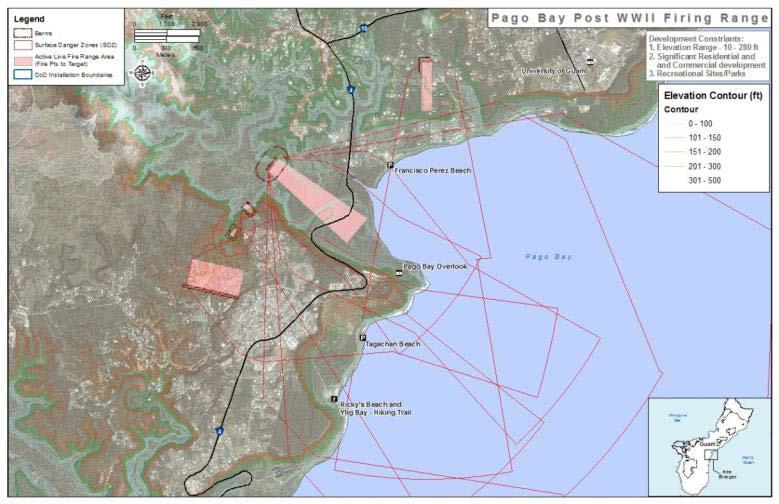
141 139


142 Comments received on the FEIS also suggested that virtual training could substitute for the use of live fire training ranges. Virtual training is currently used through the military to supplement both live fire and non-live fire training. At the tactical level, virtual training prior to live fire training enhances the trainee s ability to master basic techniques and procedures, such as proper sight picture, sight alignment, target acquisition and immediate actions drills. For nonlive fire training, virtual training enhances crew performance through use of proper start-up or shut down procedures, emergency procedures and exposure to different scenario factors such as terrain, darkness or inclement weather. Virtual training results in perhaps the greatest benefit at the operational and strategic level where large scale training scenarios can be conducted with 140
Draft Environmental Impact Statement / Overseas Environmental Impact Statement
 Draft Environmental Impact Statement / Overseas Environmental Impact Statement GUAM AND CNMI MILITARY RELOCATION Relocating Marines from Okinawa, Visiting Aircraft Carrier Berthing, and Army Air and Missile
CHAPTER 2. PROPOSED ACTION AND ALTERNATIVES
 CHAPTER 2. PROPOSED ACTION AND ALTERNATIVES 2.1 OVERVIEW The proposed action consists of development of facilities and infrastructure on Guam to support relocating approximately 600 military personnel
Officer In Charge of Construction (OICC) Marine Corps Marianas Overview Brief for GEDA Symposium
 Marine Corps Marianas Overview Brief for GEDA Symposium") Officer In Charge of Construction (OICC) Marine Corps Marianas Overview Brief for GEDA Symposium 1 CAPT Dan Turner Commanding Officer February 23, 2017 Presentation Clarifying Guidance DISCLAIMER: Although
Officer In Charge of Construction (OICC) Marine Corps Marianas Overview Brief for GEDA Symposium 1 CAPT Dan Turner Commanding Officer February 23, 2017 Presentation Clarifying Guidance DISCLAIMER: Although
TOWNSEND BOMBING RANGE MODERNIZATION
 Frequently Asked Questions August 2011 BACKGROUND... 3 Who owns, operates, and uses Townsend Bombing Range?... 3 What is the primary purpose of TBR?... 3 Where is TBR located?... 3 When did TBR begin its
Scoping Summary Report
 Final Scoping Summary Report Guam and CNMI Military Relocation (2012 Roadmap Adjustments) Supplemental Environmental Impact Statement Prepared for: Joint Guam Program Office Washington, D.C. Prepared by:
Proposal for Land Acquisition and Airspace Establishment in Support of Large-Scale MAGTF Live Fire and Maneuver Training
 Proposal for Land Acquisition and Airspace Establishment in Support of Large-Scale MAGTF Live Fire and Maneuver Training Public Information Brief February 14, 2013 Marine Air Ground Task Force Training
Environmental Impact Statement/Overseas Environmental Impact Statement (EIS/OEIS) for the Northwest Training Range Complex (NWTRC). An EIS/OEIS is con
 for the Northwest Training Range Complex (NWTRC). An EIS/OEIS is con") Environmental Impact Statement/Overseas Environmental Impact Statement (EIS/OEIS) for the Northwest Training Range Complex (NWTRC). An EIS/OEIS is considered to be the appropriate document for this review
Environmental Impact Statement/Overseas Environmental Impact Statement (EIS/OEIS) for the Northwest Training Range Complex (NWTRC). An EIS/OEIS is considered to be the appropriate document for this review
4.17 PUBLIC HEALTH AND SAFETY
 4.17 PUBLIC HEALTH AND SAFETY Section 4.17 describes the potential impacts to public health and safety as a result of the proposed action. The region of influence for construction activities includes the
29Palms Training Land/Airspace Acquisition Project Project Description Paper Number 9
 Proposed Land Acquisition/Airspace Establishment in Support of Large-Scale MAGTF Live-Fire and Maneuver Training Project Description Paper Issue 9 July 2015 Marine Air Ground Task Force Training Command
Appendix E: Public Participation
 Appendix E: Public Participation TABLE OF CONTENTS APPENDIX E PUBLIC PARTICIPATION... E-1 E.1 PROJECT WEBSITE... E-1 E.2 GENERAL SUMMARY OF THE SCOPING PERIOD... E-1 E.2.1 PUBLIC SCOPING NOTIFICATION...
PA for Military Relocation to Guam and CNMI. 15 September 2010 Page 1
 Page 1 PROGRAMMATIC AGREEMENT AMONG THE DEPARTMENT OF DEFENSE 1, THE ADVISORY COUNCIL ON HISTORIC PRESERVATION, THE GUAM STATE HISTORIC PRESERVATION OFFICER, COMMONWEALTH OF THE NORTHERN MARIANAS STATE
PUBLIC NOTICE Application for Permit
 PUBLIC NOTICE Application for Permit 30-Day Notice Issue Date: January 24, 2017 Expiration Date: February 22, 2017 US Army Corps of Engineers No: NWP-2007-5/2 Oregon Department of State Lands No: N/A Interested
Proposal for Land Acquisition and Airspace Establishment in Support of Large-Scale MAGTF Live Fire and Maneuver Training
 Proposal for Land Acquisition and Airspace Establishment in Support of Large-Scale MAGTF Live Fire and Maneuver Training Public Information Brief June, 2015 Marine Air Ground Task Force Training Command/
Department of Defense INSTRUCTION
 Department of Defense INSTRUCTION NUMBER 4715.9 May 3, 1996 USD(A&T) SUBJECT: Environmental Planning and Analysis References: (a) DoD Directive 4715.1, Environmental Security, February 24, 1996 (b) DoD
Public Notice U.S. ARMY CORPS OF ENGINEERS, GALVESTON DISTRICT AND TEXAS COMMISSION ON ENVIRONMENTAL QUALITY
 Public Notice U.S. Army Corps Permit Application No: SWG-2012-00381 Of Engineers Date Issued: April 27, 2016 Galveston District Comments Due: May 30, 2017 U.S. ARMY CORPS OF ENGINEERS, GALVESTON DISTRICT
REQUEST FOR STATEMENTS OF INTEREST NUMBER N R-800X PROJECT TO BE INITIATED IN FISCAL YEAR 2018
 REQUEST FOR STATEMENTS OF INTEREST NUMBER N40192-18-R-800X PROJECT TO BE INITIATED IN FISCAL YEAR 2018 Project Title: SEA TURTLE MONITORING, PROTECTION, AND EDUCATIONAL OUTREACH ON ANDERSEN AIR FORCE BASE
Welcome. Environmental Impact Statement for Multiple Projects in Support of Marine Barracks Washington, D.C.
 Environmental Impact Statement for Multiple Projects in Support of Marine Barracks Washington, D.C. Welcome Public Meeting Your involvement assists the Marine Corps in making an informed decision. Marine
MEMORANDUM OF AGREEMENT BETWEEN THE FLORIDA DEPARTMENT OF ENVIRONMENTAL PROTECTION AND THE UNITED STATES ENVIRONMENTAL PROTECTION AGENCY
 ***DRAFT DELIBERATIVE. DO NOT RELEASE UNDER FOIA. NOTHING CONTAINED HEREIN SHALL BE CONSTRUED AS CREATING ANY RIGHTS OR BINDING EITHER PARTY*** MEMORANDUM OF AGREEMENT BETWEEN THE FLORIDA DEPARTMENT OF
Consolidation Plan for Facilities and Areas in Okinawa. April 2013
 Consolidation Plan for Facilities and Areas in Okinawa April 2013 Table of Contents Section 1 - Introduction I. Overview II. Notes Section 2 - Land Returns III. Areas Eligible for Immediate Return Upon
OPNAVINST N46 24 Apr Subj: MISSION, FUNCTIONS, AND TASKS OF NAVAL FACILITIES ENGINEERING COMMAND
 DEPARTMENT OF THE NAVY OFFICE OF THE CHIEF OF NAVAL OPERATIONS 2000 NAVY PENTAGON WASHINGTON, DC 20350-2000 OPNAVINST 5450.348 N46 OPNAV INSTRUCTION 5450.348 From: Chief of Naval Operations Subj: MISSION,
Report No. D July 25, Guam Medical Plans Do Not Ensure Active Duty Family Members Will Have Adequate Access To Dental Care
 Report No. D-2011-092 July 25, 2011 Guam Medical Plans Do Not Ensure Active Duty Family Members Will Have Adequate Access To Dental Care Report Documentation Page Form Approved OMB No. 0704-0188 Public
Department of Defense INSTRUCTION
 Department of Defense INSTRUCTION NUMBER 4715.6 April 24, 1996 USD(A&T) SUBJECT: Environmental Compliance References: (a) DoD Instruction 4120.14, "Environmental Pollution Prevention, Control and Abatement,"
Appendix C: Public Participation
 Appendix C: Public Participation TABLE OF CONTENTS APPENDIX C PUBLIC PARTICIPATION... C-1 C.1 PROJECT WEBSITE... C-1 C.2 GENERAL SUMMARY OF THE SCOPING PERIOD... C-1 C.2.1 TRIBAL NOTIFICATION LETTERS...
Advance Questions for Buddie J. Penn Nominee for Assistant Secretary of the Navy for Installations and Environment
 Advance Questions for Buddie J. Penn Nominee for Assistant Secretary of the Navy for Installations and Environment Defense Reforms Almost two decades have passed since the enactment of the Goldwater- Nichols
TRANSPORTATION ALTERNATIVES (TA) SET ASIDE PROGRAM July 2016
 SET ASIDE PROGRAM July 2016") Regional Transportation Commission TRANSPORTATION ALTERNATIVES (TA) SET ASIDE PROGRAM July 2016 Contents 1.0 Purpose and Eligibility... 2 2.0 Process... 5 3.0 Implementation of Funded Projects... 5 Attachment
Regional Transportation Commission TRANSPORTATION ALTERNATIVES (TA) SET ASIDE PROGRAM July 2016 Contents 1.0 Purpose and Eligibility... 2 2.0 Process... 5 3.0 Implementation of Funded Projects... 5 Attachment
EXECUTIVE SUMMARY. Florida; (3) Elmendorf AFB, Alaska; (4) Mountain Home AFB, Idaho; (5) Tyndall AFB, Florida; and (6) Nellis AFB, Nevada.
 Elmendorf AFB, Alaska; (4) Mountain Home AFB, Idaho; (5) Tyndall AFB, Florida; and (6) Nellis AFB, Nevada.") EXECUTIVE SUMMARY This Draft Environmental Impact Statement (EIS) analyzes the Air Force proposal to locate or beddown 72 operational F-22 aircraft at an existing Air Force base. The United States Congress
EXECUTIVE SUMMARY This Draft Environmental Impact Statement (EIS) analyzes the Air Force proposal to locate or beddown 72 operational F-22 aircraft at an existing Air Force base. The United States Congress
What is the 29 Palms Proposed Training Land Acquisition and Airspace Establishment Project? Frequently Asked Questions July 27, 2012
 FINAL ENVIRONMENTAL IMPACT STATEMENT (EIS) MADE AVAILABLE FOR PUBLIC REVIEW 1. What are the major changes between the Draft EIS and the Final EIS? An additional mitigation measure for recreation was developed
Welcome Scoping Meeting U.S. Navy Environmental Impact Statement for the EA-18G Growler Airfield Operations at Naval Air Station (NAS) Whidbey Island
 Whidbey Island") Welcome Scoping Meeting U.S. Navy Environmental Impact Statement for the EA-18G Growler Airfield Operations at Naval Air Station (NAS) Whidbey Island Open House Public Scoping Meetings 4:00 pm to 8:00
Welcome Scoping Meeting U.S. Navy Environmental Impact Statement for the EA-18G Growler Airfield Operations at Naval Air Station (NAS) Whidbey Island Open House Public Scoping Meetings 4:00 pm to 8:00
MEMORANDUM OF UNDERSTANDING COOPERATIVE ECOSYSTEM STUDIES UNITS NETWORK
 MEMORANDUM OF UNDERSTANDING Continuation of the COOPERATIVE ECOSYSTEM STUDIES UNITS NETWORK among the NATIONAL AERONAUTICS AND SPACE ADMINISTRATION U.S. DEPARTMENT OF AGRICULTURE Agricultural Research
Frequently Asked Questions (FAQs) and SEIS Fact Sheet
 and SEIS Fact Sheet") Frequently Asked Questions (FAQs) and SEIS Fact Sheet 1. What has happened since the 2012 Land Acquisition EIS? The Environmental Impact Statement (EIS) and National Environmental Policy Act (NEPA) process
Frequently Asked Questions (FAQs) and SEIS Fact Sheet 1. What has happened since the 2012 Land Acquisition EIS? The Environmental Impact Statement (EIS) and National Environmental Policy Act (NEPA) process
COASTAL CONSERVANCY. Staff Recommendation June 16, 2005 MALIBU ACCESS: DAN BLOCKER BEACH. File No Project Manager: Marc Beyeler
 COASTAL CONSERVANCY Staff Recommendation June 16, 2005 MALIBU ACCESS: DAN BLOCKER BEACH File No. 03-163 Project Manager: Marc Beyeler RECOMMENDED ACTION: Authorization to augment the Conservancy s January
Regulatory Guidance Letter 92-01
 Regulatory Guidance Letter 92-01 SUBJECT: Federal Agencies Roles and Responsibilities DATE: May 12, 1992 EXPIRES: December 31, 1997 1. PURPOSE: The purpose of this guidance is to clarify the Army Corps
Army National Guard Nepa Handbook 2011
 Army National Guard Nepa Handbook 2011 The National Environmental Policy Act of 1969 (NEPA) requires federal through regulations promulgated by the Council on Environmental Quality (CEQ) (40 required to
PUBLIC NOTICE. Section 404 of the Clean Water Act (33 U.S.C. 1344) Section 10 of the Rivers and Harbors Act of 1899 (33 U.S.C.
 Section 10 of the Rivers and Harbors Act of 1899 (33 U.S.C.") US Army Corps Of Engineers Wilmington District PUBLIC NOTICE Issue Date: March 1, 2018 Comment Deadline: April 2, 2018 Corps Action ID Number: SAW-2011-02228 The Wilmington District, Corps of Engineers
US Army Corps Of Engineers Wilmington District PUBLIC NOTICE Issue Date: March 1, 2018 Comment Deadline: April 2, 2018 Corps Action ID Number: SAW-2011-02228 The Wilmington District, Corps of Engineers
U.S. ARMY CORPS OF ENGINEERS BUILDING STRONG LOS ANGELES DISTRICT
 PUBLIC NOTICE U.S. ARMY CORPS OF ENGINEERS BUILDING STRONG LOS ANGELES DISTRICT NOTICE OF AVAILABILITY (NOA) For FINAL ENVIRONMENTAL IMPACT STATEMENT (EIS) and DRAFT GENERAL CONFORMITY DETERMINATION (GCD)
PUBLIC NOTICE Application for Permit
 PUBLIC NOTICE Application for Permit 30-Day Notice Issue Date: April 19, 2016 Expiration Date: May 19, 2016 US Army Corps of Engineers No: NWP-2014-37/2 Oregon Department of State Lands No: 56882-RF Interested
Defense Environmental Funding
 1 Defense Environmental Funding The Department of Defense (DoD) funds its environmental programs through effective planning, programming, budgeting, and execution processes that allocate financial resources
GENERAL ASSEMBLY OF NORTH CAROLINA SESSION 2013 SESSION LAW HOUSE BILL 484
 GENERAL ASSEMBLY OF NORTH CAROLINA SESSION 2013 SESSION LAW 2013-51 HOUSE BILL 484 AN ACT TO ESTABLISH A PERMITTING PROGRAM FOR THE SITING AND OPERATION OF WIND ENERGY FACILITIES. The General Assembly
S One Hundred Seventh Congress of the United States of America AT THE FIRST SESSION
 An Act S.1438 One Hundred Seventh Congress of the United States of America AT THE FIRST SESSION To authorize appropriations for fiscal year 2002 for military activities of the Department of Defense, for
Conservation Appendix C: Conservation Budget Overview
 The Department of Defense (DoD) is a major user of land, sea, and air spaces and manages 30 million acres of land on more than 425 major military installations and is the third largest federal land management
APPENDIX 1 BROWARD COUNTY PLANNING COUNCIL PLAN AMENDMENT REQUIREMENTS AND PROCEDURES
 APPENDIX 1 BROWARD COUNTY PLANNING COUNCIL PLAN AMENDMENT REQUIREMENTS AND PROCEDURES Broward County Land Use Plan Amendment Requirements Amendments which are not within the rules of flexibility or more
A FUTURE MARITIME CONFLICT
 Chapter Two A FUTURE MARITIME CONFLICT The conflict hypothesized involves a small island country facing a large hostile neighboring nation determined to annex the island. The fact that the primary attack
CHAPTER 1 PURPOSE, NEED, AND SCOPE
 CHAPTER 1 PURPOSE, NEED, AND SCOPE 1.1 INTRODUCTION 1-1 1.2 BACKGROUND 1-3 1.3 PURPOSE OF THE PROPOSED ACTION 1-4 1.4 NEED FOR THE PROPOSED ACTION 1-4 1.5 SCOPE OF ANALYSIS 1-5 1.6 DECISION(S) TO BE MADE
INTERGOVERNMENTAL COORDINATION ELEMENT:
 INTERGOVERNMENTAL COORDINATION ELEMENT: Goals, Objectives and Policies Goal 1: To give the Town the maximum amount of input, control, and advisory power with other public agencies for the protection of
Subj: COMPLIANCE WITH ENVIRONMENTAL REQUIREMENTS IN THE CONDUCT OF NAVAL EXERCISES OR TRAINING AT SEA
 MEMORANDUM FOR THE CHIEF OF NAVAL OPERATIONS COMMANDANT OF MARINE CORPS 28 December 2000 Subj: COMPLIANCE WITH ENVIRONMENTAL REQUIREMENTS IN THE CONDUCT OF NAVAL EXERCISES OR TRAINING AT SEA Ref: (a) OPNAVINST
Public Notice U.S. ARMY CORPS OF ENGINEERS, GALVESTON DISTRICT AND TEXAS COMMISSION ON ENVIRONMENTAL QUALITY
 Public Notice U.S. Army Corps Permit Application No: SWG-2015-00306 Of Engineers Date Issued: 14 January 2016 Galveston District Comments Due: 16 February 2016 U.S. ARMY CORPS OF ENGINEERS, GALVESTON DISTRICT
Commonwealth Transportation Board Briefing
 Hampton Roads Crossing Study (HRCS) (SEIS) Commonwealth Transportation Board Briefing September 20, 2016 Angel Deem VDOT, Environmental Division Director HRCS History 1991: Federal funding allocated for
FOREST SERVICE MANUAL NATIONAL HEADQUARTERS (WO) WASHINGTON, DC
 WASHINGTON, DC") Page 1 of 39 Information on how to comment is available online at http://www.fs.usda.gov/goto/planningrule/directives. FOREST SERVICE MANUAL NATIONAL HEADQUARTERS (WO) WASHINGTON, DC CHAPTER 1920 LAND
Page 1 of 39 Information on how to comment is available online at http://www.fs.usda.gov/goto/planningrule/directives. FOREST SERVICE MANUAL NATIONAL HEADQUARTERS (WO) WASHINGTON, DC CHAPTER 1920 LAND
APPENDIX A PROGRAMMATIC AGREEMENT FOR MINOR TRANSPORTATION PROJECTS
 APPENDIX A PROGRAMMATIC AGREEMENT FOR MINOR TRANSPORTATION PROJECTS PROGRAMMATIC AGREEMENT AMONG THE FEDERAL HIGHWAY ADMINISTRATION THE PENNSYLVANIA DEPARTMENT OF TRANSPORTATION, THE PENNSYLVANIA STATE
PROPOSED ACTION AND ALTERNATIVES... I
 April 2015 Draft Table of Contents CHAPTER 2 PROPOSED ACTION AND ALTERNATIVES Table of Contents CHAPTER 2 PROPOSED ACTION AND ALTERNATIVES... I ACRONYMS AND ABBREVIATIONS... IV 2.1 OVERVIEW OF THE PROPOSED
OPNAVINST G N514 8 Jan Subj: RELEASE OF INFORMATION ON NUCLEAR WEAPONS AND ON NUCLEAR CAPABILITIES OF U.S. NAVY FORCES
 DEPARTMENT OF THE NAVY OFFICE OF THE CHIEF OF NAVAL OPERATIONS 2000 NAVY PENTAGON WASHINGTON, DC 20350-2000 OPNAVINST 5721.1G N514 OPNAV INSTRUCTION 5721.1G From: Chief of Naval Operations Subj: RELEASE
Department of Defense DIRECTIVE
 Department of Defense DIRECTIVE NUMBER 2010.9 April 28, 2003 Certified Current as of November 24, 2003 SUBJECT: Acquisition and Cross-Servicing Agreements USD(AT&L) References: (a) DoD Directive 2010.9,
DEPARTMENT OF THE ARMY U.S. ARMY CORPS OF ENGINEERS, SACRAMENTO DISTRICT 1325 J STREET SACRAMENTO CA PUBLIC NOTICE
 DEPARTMENT OF THE ARMY U.S. ARMY CORPS OF ENGINEERS, SACRAMENTO DISTRICT 1325 J STREET SACRAMENTO CA 95814-2922 Operations and Readiness Branch PUBLIC NOTICE REQUEST FOR PERMISSION TO ALTER A US ARMY CORPS
Exemptions from Environmental Law for the Department of Defense: Background and Issues for Congress
 Order Code RS22149 Updated August 17, 2007 Summary Exemptions from Environmental Law for the Department of Defense: Background and Issues for Congress David M. Bearden Specialist in Environmental Policy
PUBLIC NOTICE. Attn: Mr. Christopher Layton 1200 Duck Road Duck, North Carolina CB&I 4038 Masonboro Loop Road Wilmington, North Carolina 28409
 US Army Corps Of Engineers Wilmington District PUBLIC NOTICE Issue Date: January 15, 2015 Comment Deadline: February 16, 2015 Corps Action ID Number: SAW-2014-02202 The Wilmington District, Corps of Engineers
Sustaining the Readiness of North Carolina s Military September 10, 2013
 Sustaining the Readiness of North Carolina s Military September 10, 2013 Mark Sutherland Vice President NC s Eastern Region sutherland@nceast.org Topics Encroachment, readiness and the military value of
Final Supplemental Environmental Impact Statement APPENDIX C: COORDINATION PLAN
 TABLE 1: AGENCIES AND CONSULTING PARTIES Final Supplemental Environmental Impact Statement Role Federal Federal Tribes Virginia Local / Others Federal Highway Administration N/A N/A Lead Agency Transportation
WHO'S IN AND WHO'S OUT
 WHO'S IN AND WHO'S OUT The Best Places to Work in the Federal Government rankings, produced by the Partnership for Public Service since 2003, are based almost entirely on data from the Office of Personnel
DEPARTMENT OF THE ARMY GENERAL PERMIT
 DEPARTMENT OF THE ARMY Wilmington District, Corps of Engineers 69 Darlington A venue Wilmington, North Carolina 28403-1343 http://www.saw.usace.army.mil/wetlands/index.html General Permit No. 198000291
WRP Natural Resources Committee s Southeastern Arizona/New Mexico (SoAZ/NM Project)
") 2015 WRP Natural Resources Committee s Southeastern Arizona/New Mexico (SoAZ/NM Project) SoAZ/NM Project: A formula for success. As a direct result of this project s efforts, the area: Won the 2014 REPI
2015 WRP Natural Resources Committee s Southeastern Arizona/New Mexico (SoAZ/NM Project) SoAZ/NM Project: A formula for success. As a direct result of this project s efforts, the area: Won the 2014 REPI
NAS North Island WELCOME. Open House Public Meeting
 NAS North Island WELCOME Open House Public Meeting for the Transition from C-2A to CMV-22B Aircraft at Naval Air Station North Island, CA and Naval Station Norfolk, VA January 18, 2018 4:00 PM to 6:00
Foreword. Mario P. Fiori Assistant Secretary of the Army (Installations and Environment)
") April 2003 Army Environmental Cleanup Strategy Foreword I am pleased to present the Army s Environmental Cleanup Strategy. The Strategy provides a roadmap to guide the Army in attaining its environmental
April 2003 Army Environmental Cleanup Strategy Foreword I am pleased to present the Army s Environmental Cleanup Strategy. The Strategy provides a roadmap to guide the Army in attaining its environmental
SPD Emergency Procedures and SPK Regional General Permit 8 for Emergency Actions
 SPD Emergency Procedures and SPK Regional General Permit 8 for Emergency Actions Regulatory Program Workshop November 6, 2015 Zachary Fancher Project Manager, California North Branch Sacramento District
What is the 29 Palms Training Land Acquisition and Airspace Establishment Project Frequently Asked Questions July 2015
 NATIONAL DEFENSE AUTHORIZATION ACT FOR FISCAL YEAR 2014 (NDAA) ENACTED DECEMBER 26 2013 1. Did Congress approve a modified version of Alternative 6, the Preferred Alternative, to meet the Marine Corps
COORDINATION PLAN. September 30, 2011
 COORDINATION PLAN September 30, 2011 TABLE 1: AGENCIES AND CONSULTING PARTIES Role Federal Agencies Virginia Agencies Local Agencies / Others Lead Agency Federal Highway Administration (FHWA) Transportation
Partners for a Compatible Future NAF El Centro
 Partners for a Compatible Future NAF El Centro WHO WE ARE Naval Air Facility (NAF) El Centro is a 2,800-acre fleet training complex with oversight of 54,000 acres of training ranges. The primary function
STATE ENVIRONMENTAL REVIEW PROCESS FOR PENNSYLVANIA WASTEWATER PROJECTS. Clean Water State Revolving Fund Program
 A STATE ENVIRONMENTAL REVIEW PROCESS FOR PENNSYLVANIA WASTEWATER PROJECTS Clean Water State Revolving Fund Program Pennsylvania Infrastructure Investment Authority & Pennsylvania Department of Environmental
Army. Environmental. Cleanup. Strategy
 Army Environmental Cleanup Strategy April 2003 28 April 2003 Army Environmental Cleanup Strategy Foreword I am pleased to present the Army s Environmental Cleanup Strategy. The Strategy provides a roadmap
FUTURE U.S. NAVY AND USCG OPERATIONS IN THE ARCTIC
 Working Document of the NPC Study: Arctic Potential: Realizing the Promise of U.S. Arctic Oil and Gas Resources Made Available March 27, 2015 Paper #7-13 FUTURE U.S. NAVY AND USCG OPERATIONS IN THE ARCTIC
DEPARTMENT OF THE ARMY U.S. ARMY CORPS OF ENGINEERS, SAVANNAH DISTRICT 1590 ADAMSON PARKWAY, SUITE 200 MORROW, GEORGIA FEB O
 DEPARTMENT OF THE ARMY U.S. ARMY CORPS OF ENGINEERS, SAVANNAH DISTRICT 1590 ADAMSON PARKWAY, SUITE 200 MORROW, GEORGIA 30260-1777 FEB O 2 2018 Regulatory Branch SAS-2002-03090 JOINT PUBLIC NOTICE Savannah
***************************************************************** TQL
 ---------------------------------TQL----------------------------- DEPARTMENT OF THE NAVY VISION, GUIDING PRINCIPLES, AND STRATEGIC GOALS AND STRATEGIC PLAN FOR TOTAL QUALITY LEADERSHIP Published for the
Corps Regulatory Program Update
 Corps Regulatory Program Update Presentation for the National Association of Flood and Stormwater Management Agencies David Olson Headquarters, U.S. Army Corps of Engineers August 25, 2016 1 BUILDING STRONG
FORWARD, READY, NOW!
 FORWARD, READY, NOW! The United States Air Force (USAF) is the World s Greatest Air Force Powered by Airmen, Fueled by Innovation. USAFE-AFAFRICA is America s forward-based combat airpower, delivering
SAFETEA-LU. Overview. Background
 SAFETEA-LU This document provides information related to the Safe, Accountable, Flexible, Efficient Transportation Equity Act: A Legacy for Users (SAFETEA-LU) that was previously posted on the Center for
Department of Defense INSTRUCTION. SUBJECT: Management of Environmental Compliance at Overseas Installations
 Department of Defense INSTRUCTION NUMBER 4715.5 April 22, 1996 SUBJECT: Management of Environmental Compliance at Overseas Installations USD(A&T) References: (a) DoD Directive 6050.16, "DoD Policy for
Guidance for Urban/Metropolitan Area Installation/Bases
 Defense Access Road (DAR) Program Eligibility Guidance Guidance for Urban/Metropolitan Area Installation/Bases November 2013 Purpose for Additional DAR Program Guidance Department of Defense (DOD) military
PUBLIC NOTICE.
 US Army Corps Of Engineers Wilmington District PUBLIC NOTICE Issue Date: January 19, 2017 Comment Deadline: February 17, 2017 Corps Action ID Number: SAW-2011-01243 The Wilmington District, Corps of Engineers
ALLIANCE MARITIME STRATEGY
 ALLIANCE MARITIME STRATEGY I. INTRODUCTION 1. The evolving international situation of the 21 st century heralds new levels of interdependence between states, international organisations and non-governmental
DEPARTMENT OF THE NAVY OFFICE OF THE CHIEF OF NAVAL OPERATIONS 2000 NAVY PENTAGON WASHINGTON, DC
 DEPARTMENT OF THE NAVY OFFICE OF THE CHIEF OF NAVAL OPERATIONS 2000 NAVY PENTAGON WASHINGTON, DC 20350-2000 OPNAVINST 3380.5A N314 OPNAV INSTRUCTION 3380.5A From: Chief of Naval Operations Subj: HIGH-VALUE
DEPARTMENT OF HOMELAND SECURITY REORGANIZATION PLAN November 25, 2002
 DEPARTMENT OF HOMELAND SECURITY REORGANIZATION PLAN November 25, 2002 Introduction This Reorganization Plan is submitted pursuant to Section 1502 of the Department of Homeland Security Act of 2002 ( the
Proposed Connector between Airline Highway (US 61) and Interstate 10 in St. John the Baptist Parish
 and Interstate 10 in St. John the Baptist Parish") DRAFT COORDINATION PLAN Proposed Connector between Airline Highway (US 61) and Interstate 10 in St. John the Baptist Parish OCTOBER 2, 2009 State Project No. 70-48-0101 Federal Aid No. HP-TO21(517) RPC
DRAFT COORDINATION PLAN Proposed Connector between Airline Highway (US 61) and Interstate 10 in St. John the Baptist Parish OCTOBER 2, 2009 State Project No. 70-48-0101 Federal Aid No. HP-TO21(517) RPC
Public Notice of Re-Authorization for General Permit
 U.S. Army Corps Of Engineers Honolulu District Public Notice of Re-Authorization for General Permit Regulatory Branch Building 230, Ft. Shafter Honolulu, HI 96858-5440 PUBLIC NOTICE DATE: August 25, 2005
Department of Defense DIRECTIVE
 Department of Defense DIRECTIVE SUBJECT: Transportation and Traffic Management NUMBER 4500.09E September 11, 2007 Incorporating Change 1, July 31, 2017 USD(AT&L) References: (a) DoD Directive 4500.9E,
Jacksonville Range Complex Final Environmental Impact Statement/ Overseas Environmental Impact Statement (EIS/OEIS) Volume 1
 Volume 1") Jacksonville Range Complex Final Environmental Impact Statement/ Overseas Environmental Impact Statement (EIS/OEIS) Volume 1 Prepared by: United States Fleet Forces March 2009 This page intentional left
Jacksonville Range Complex Final Environmental Impact Statement/ Overseas Environmental Impact Statement (EIS/OEIS) Volume 1 Prepared by: United States Fleet Forces March 2009 This page intentional left
Department of Defense DIRECTIVE
 Department of Defense DIRECTIVE NUMBER 3025.12 February 4, 1994 USD(P) SUBJECT: Military Assistance for Civil Disturbances (MACDIS) References: (a) DoD Directive 3025.12, "Employment of Military Resources
This Page Intentionally Left Blank
 This Page Intentionally Left Blank OCEAN SSTEWARD U..SS.. Cooaasst t Guuaar rdd Maar rinnee PPr root teecct teedd SSppeecci ieess SSt traat teeggi icc PPl laann TABLE OFF CONTENTSS Ocean Steward s Purpose
APPENDIX: FUNCTIONAL COMMUNITIES Last Updated: 21 December 2015
 FUNCTIONAL Acquisition APPENDIX: FUNCTIONAL COMMUNITIES Last Updated: 21 December 2015 ROLE Plans for, develops, and procures everything from initial spare parts to complete weapons and support systems,
HOMELAND SECURITY PRESIDENTIAL DIRECTIVE-4. Subject: National Strategy to Combat Weapons of Mass Destruction
 [National Security Presidential Directives -17] HOMELAND SECURITY PRESIDENTIAL DIRECTIVE-4 Unclassified version December 2002 Subject: National Strategy to Combat Weapons of Mass Destruction "The gravest
Chapter 4 Implementation and Reuse
 Chapter 4 Implementation and Reuse When implementing decisions during the past four BRAC rounds, the Department worked diligently to assist its military and civilian personnel in transition, to transfer
Public Notice NOTICE ANNOUNCING MINOR MODIFICATIONS TO THE LETTER OF PERMISSION AUTHORIZING TRANSPORATION PROJECTS
 Public Notice US Army Corps of Engineers Louisville, Huntington, Memphis, Nashville Districts Public Notice No. Date: Closing Date: LRL-2006-259-pgj 28 Oct 10 N/A Please address all comments and inquiries
DEPARTMENT OF THE ARMY ER U.S. Army Corps of Engineers CECW-P Washington, DC Regulation No February 2016
 DEPARTMENT OF THE ARMY ER 1165-2-211 U.S. Army Corps of Engineers CECW-P Washington, DC 20314-1000 Regulation No. 1165-2-211 4 February 2016 Water Resource Policies and Authorities OPERATION AND MAINTENANCE
South Sacramento HCP Regional General Permit
 South Sacramento HCP Regional General Permit MINIMAL IMPACT COVERED ACTIVITIES CONDUCTED UNDER THE SOUTH SACRAMENTO HABITAT CONSERVATION PLAN IN-LIEU FEE PROGRAM EFFECTIVE: EXPIRES: (5 years from effective
EXECUTIVE SUMMARY. Global Hawk Main Operating Base Beddown EA
 EXECUTIVE SUMMARY EXECUTIVE SUMMARY Global Hawk Main Operating Base Beddown EA This final Environmental Assessment (EA) describes the potential environmental consequences resulting from a U.S. Air Force
Project Priority Scoring System Texas Recreation & Parks Account Non-Urban Indoor Recreation Grant Program (Effective May 1, 2014)
") Project Priority Scoring System Texas Recreation & Parks Account Non-Urban Indoor Recreation Grant Program (Effective May 1, 2014) Applicant Eligibility All previously completed Recreation Grant Projects
Project Priority Scoring System Texas Recreation & Parks Account Non-Urban Indoor Recreation Grant Program (Effective May 1, 2014) Applicant Eligibility All previously completed Recreation Grant Projects
Frameworks for Responses to Armed Attack Situations
 Section 2 Frameworks for Responses to Armed Attack Situations It is of utmost importance for the national government to establish a national response framework as a basis for an SDF operational structure
FINDING OF NO SIGNIFICANT IMPACT: CONVERSION OF 5-5 AIR DEFENSE ARTILLERY BATTALION AT JOINT BASE LEWIS-MCCHORD
 FINDING OF NO SIGNIFICANT IMPACT: CONVERSION OF 5-5 AIR DEFENSE ARTILLERY BATTALION AT JOINT BASE LEWIS-MCCHORD Pursuant to the Council on Environmental Quality (CEQ) Regulations (40 CFR [Code of Federal
FOR IMMEDIATE RELEASE No June 27, 2001 THE ARMY BUDGET FISCAL YEAR 2002
 FOR IMMEDIATE RELEASE No. 01-153 June 27, 2001 THE ARMY BUDGET FISCAL YEAR 2002 Today, the Army announced details of its budget for Fiscal Year 2002, which runs from October 1, 2001 through September 30,
Readiness and Environmental Protection Integration (REPI) Program Overview. NMFWA Webinar 16 July 2013
 Program Overview. NMFWA Webinar 16 July 2013") Readiness and Environmental Protection Integration (REPI) Program Overview NMFWA Webinar 16 July 2013 1 REPI Program Overview Agenda Agenda I. Overview of the REPI Program II. III. IV. VI. VII. VIII. Buffer
Readiness and Environmental Protection Integration (REPI) Program Overview NMFWA Webinar 16 July 2013 1 REPI Program Overview Agenda Agenda I. Overview of the REPI Program II. III. IV. VI. VII. VIII. Buffer
Bruce Goff, Barb Giacomini, Noah Stewart, and Larry Dean Anteon Corporation San Diego, CA USA.
 Bruce Goff, Barb Giacomini, Noah Stewart, and Larry Dean San Diego, CA USA www.anteon.com Purpose and Need for Desert Scimitar Exercise Annual 1 st Marine Division live-fire exercise at Marine Corps Air
Executive Summary EXECUTIVE SUMMARY
 EXECUTIVE SUMMARY ES INTRODUCTION AND BACKGROUND On October 14, 2011, the Army published a Notice of Availability (NOA) of a Draft Programmatic Environmental Impact Statement (PEIS) for the Modernization