US Navy s GeoReadiness, CPLO Support, & Community Planning
|
|
|
- Arthur Stokes
- 5 years ago
- Views:
Transcription


1 US Navy s GeoReadiness, CPLO Support, & Community Planning NAVFAC SE GeoReadiness Center (GRC) NAS Jacksonville FL Ryan Warne, Sr. GIS Analyst Ryan.Warne.ctr@navy.mil 1 1
2 2 2


3 What is NAVFAC? Naval Facilities Engineering Command A Systems Command that buildings and maintains facilities, delivers utilities and services, and provides Navy expeditionary combat force capabilities. With 18,000+ Civil Engineer Corps officers, civilians and contractors, deliver the best value facilities engineering and acquisition for the Navy & Marine Corps. 3 3


4 GeoReadiness Program Mission & Vision Mission: GeoReadiness delivers, maintains, and provides access to authoritative geospatial data to improve situational awareness and strengthen decision-making at Navy shore and expeditionary installations. Vision: Empower users with Easily accessible, precise and up-to-date geospatial information delivered from a common data and technology foundation, connected to location-enabled Navy systems, and Enhanced decision support tools for contingency, consequence and facilities management of Navy shore and expeditionary missions. 4 4


5 GeoReadiness Concept Locally Owned and Operated Regional Centers Supporting the Navy Shore Installation mission to achieve: Readiness, Performance & Sustainability Corporately Connected 5 5


6 Geospatial Systems Are Helping Us Understand Understanding Sharing and Collaboration Knowledge Information Integration Mapping Data... Helping Us Make Better Decisions 6 6

7 NAVFAC Southeast Region 7 7
8 CPLO = Community Plans & Liaison Officer What is a CPLO? Installation Commanding Officer s direct representative with: Local communities Elected Officials City Council County Commission State Agencies Major Landowners Chamber of Commerce School Board NGOs Etc, etc. Why is this important? Navy installations attract development (people want to live near where they work) Navy is part of the community Protect the Mission of the Installation & the Public Develop strategic plans & partnerships. 8 8
9 Geospatial Data Layers Installation Boundary Fencing Tree Height & Growth Potential Towers Existing Land Use Future Land Use Zoning Land Development Potential Wetlands Flood Zones Reef conditions Windmill locations Bird Migrations Endangered Species Critical Habitats Alternative Energy Projects Cemeteries Archaeological sites Pollutants Transportation Corridors Utility Corridors Airfield Obstructions Census tracts & population Imaginary Surfaces Accident Potential Zones Noise Contours Current Imagery Etc. etc. 9 9

10 Studies to Protect the Public & the Mission AICUZ Air Installations Compatible Use Zones A program to assist governmental entities and communities in identifying and planning for compatible land use and development near military air installations. RAICUZ Range Air Installations Compatible Use Zones A program to create land use recommendations for areas exposed to potential weapons impact and noise to prevent encroachment from degrading the operational value of the range. JLUS Joint Land Use Study A collaborative study conducted by the city, county, and federal officials, residents, business, land owners, and the Navy to identify compatible land use and growth management guidelines near military installations

11 Studies to Protect the Public & the Mission AICUZ Air Installations Compatible Use Zones A program to assist governmental entities and communities in identifying and planning for compatible land use and development near military air installations. RAICUZ Range Air Installations Compatible Use Zones A program to create land use recommendations for areas exposed to potential weapons impact and noise to prevent encroachment from degrading the operational value of a range. JLUS Joint Land Use Study A collaborative study conducted by the city, county, and federal officials, residents, business, land owners, and the Navy to identify compatible land use and growth management guidelines near military installations


 Noise Levels Flight Clearance")
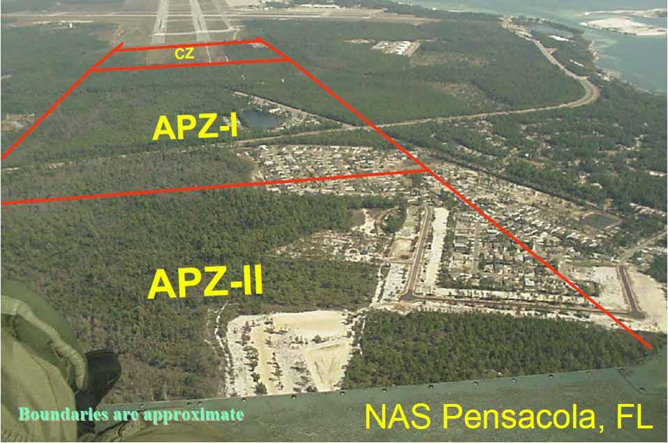
12 AICUZ Purpose: Help state and local governments promote compatible land use and development near military air installations. Considerations Accident Potential (APZ) Noise Levels Flight Clearance Requirements 12 12


13 Noise Contours & Accident Potential 13 13

14 NAS Corpus Christi APZ & Noise 14 14

15 AICUZ Land Use Compatibility 15 15

16 Virginia Beach, VA April 6,
17 17 17

18 NAS Corpus Christi Imaginary Surfaces 18 18


19 RAICUZ Purpose Help state and local governments promote compatible land use and development near military air ranges. Considerations Range safety zones Noise levels Flight clearance requirements 19 19

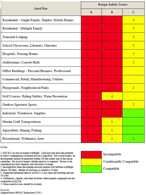
20 RAICUZ Land Use Compatibility 20 20

21 JLUS Purpose To foster a relationship between the installation and the community to act as a team to prevent or curtail encroachment issues associated with future mission expansion or local growth. The intent is to protect the resident s quality of life, property owner s rights, and existing and future missions of the installation. Considerations 21 21


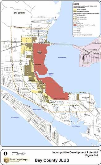
22 Bay County FL JLUS 22 22

23 JLUS Strategies 23 23
")
24 Spatial Data Standards (SDSFIE) 24 24

25 Gathering and Updating Information New GIS Deliverable 2000 AICUZ Deliverable GIS deliverable to be included in GRX 25 25

26 Map Products 26 26
27 Visualizing Data 27 27
28 GeoReadiness Explorer (GRX) GRX is a flex-based web viewer developed to facilitate the viewing and analysis of spatial data served through ESRI ArcGIS Server. It is available to any user with an active NAVFAC portal account. Contains Common Installation Picture (CIP) layers such as buildings, installation boundary, roads, parking areas, airfield surface, etc. + additions added by specialists throughout the regions. GRX can: Ingest web services from 3 rd parties Perform spatial/tabular queries Allow for on-screen mark-ups, Allow for saving and sharing mark-ups Enable map sharing between users Support search functionality for features Bookmark favorite extents Export the current view to a JPG Print the current view to a PDF View Property Records for Facilities Access Media associated with any feature Measure Areas or Linear features Place a list of coordinates on the map Export coordinates to Excel Customize saved map views for varied users Etc

29 GRX Products & Self-Service Analysis Which off-base parcels are inside a MIA? Are there wind turbines within 20 nm of the installation? Are there any endangered/threatened species habitats nearby? Do the county/city zoning rules conflict with the installation mission? 29 29

30 GRX - Noise Zones 30 30

31 Sharing Information 31 31

32 Developing Partnerships & MOUs Maintain Military Readiness Protect & Inform the public Ensure safe growth 32 32

33 GeoReadiness, CPLO Support & Community Planning Questions/Comments? 33 33
UNMANNED AIRCRAFT SYSTEMS CORRIDOR STUDY
 Scope of Work The Joint Land Use Study Implementation (JLUS) will be a series of projects that will address the recommendations in the Fort Riley Joint Land Use Study. The corridor between Fort Riley Army
MCAS BEAUFORT SUSTAINABLE RANGES BRIEF MCAS BEAUFORT COMMUNITY PLANS AND LIAISON OFFICE (CP&L)
") MCAS BEAUFORT SUSTAINABLE RANGES BRIEF MCAS BEAUFORT COMMUNITY PLANS AND LIAISON OFFICE (CP&L) LtCol. Don Noonan (843)-228-7119 Mr. Bruce Jackson (843)-228-7558 Report Documentation Page Form Approved
MCAS BEAUFORT SUSTAINABLE RANGES BRIEF MCAS BEAUFORT COMMUNITY PLANS AND LIAISON OFFICE (CP&L) LtCol. Don Noonan (843)-228-7119 Mr. Bruce Jackson (843)-228-7558 Report Documentation Page Form Approved
Compatibility Planning Near Military Bases (S562) Sponsored by Zoning Practice. APA National Planning Conference Monday, April 16, 2012
 Sponsored by Zoning Practice. APA National Planning Conference Monday, April 16, 2012") Compatibility Planning Near Military Bases (S562) Sponsored by Zoning Practice APA National Planning Conference Monday, April 16, 2012 Meet Our Panel Cyrena Eitler, AICP Department of Defense, Office
Compatibility Planning Near Military Bases (S562) Sponsored by Zoning Practice APA National Planning Conference Monday, April 16, 2012 Meet Our Panel Cyrena Eitler, AICP Department of Defense, Office
In God We Trust, All Others Must Bring Data. Installation Geospatial Information and Services in DoD
 In God We Trust, All Others Must Bring Data Installation Geospatial Information and Services in DoD Mr. David LaBranche, P.E. Geospatial Information Officer OASD(EI&E) February 24-25, 2015 ESRI FedGIS
ENCROACHMENT MANAGEMENT A Comprehensive Approach
 ENCROACHMENT MANAGEMENT A Comprehensive Approach NASA International Workshop On Environment and Alternative Energy University of California at San Diego San Diego, CA Alan F. Zusman, AICP November 4, 2010
The Defense Installation Spatial Data Infrastructure. - An Overview - JSEM US Army Installation Geospatial. US Air Force GeoBase
 US Army Installation Geospatial US Navy Information GeoReadiness & Services USMC GeoFIDELIS US Air Force GeoBase The Defense Installation Spatial Data Infrastructure - An Overview - JSEM 2006 Spatial Information
Establish a regional entity charged with enhancing the relationship between the military and civilian communities
 MILITARY INSTALLATIONS JLUS PARTNERSHIP Action 1: LAND USE Participate in the JLUS hip at the Central Midlands Council of Governments. Promote land use compatibility on land near critical training and
Air Installations Compatible Use Zones Study. Eielson Air Force Base, Alaska
 Air Installations Compatible Use Zones Study Eielson Air Force Base, Alaska 2018 Air Installations Compatible Use Zones Program The Department of Defense s (DoD s) Air Installations Compatible Use Zones
Air Installation Compatible Land Use Zone. Beale Air Force Base California Citizen s Brochure
 Air Installation Compatible Land Use Zone Beale Air Force Base California Citizen s Brochure CITIZEN S BROCHURE 1 What is AICUZ? Air Installation Compatible Use Zone (AICUZ) is a program concerning people,
Subj: READINESS SUSTAINMENT AND COMPATIBILITY PROGRAM
 DEPARTMENT OF THE NAVY COMMANDER NAVY INSTALLATIONS COMMAND 716 SICARD STREET SE SUITE 1000 WASHINGTON NAVY YARD DC 20374-5140 CNICINST 11010.1A N4 CNIC INSTRUCTION 11010.1A From: Commander, Navy Installations
Hampton Roads Region Joint Land Use Study Norfolk / Virginia Beach
 NAVFAC Mid-Atlantic Hampton Roads Region Joint Land Use Study Norfolk / Virginia Beach CAPT DEAN VANDERLEY COMMANDING OFFICER, NAVFAC MID-ATLANTIC DIRECTOR, FACILITIES & ENVIRONMENTAL NAVY REGION MID-ATLANTIC
Goals and Objectives. What is a Joint Land Use Study? The California JLUS Program. R-2508 Complex-Overview
 E X E C U T I V E S U M M A R Y May 2008 What is a Joint Land Use Study? A Joint Land Use Study ( JLUS) is a collaborative planning effort between active military installations, surrounding counties and
Getting The Boundaries Right: The DoD Real Property Inventory Mapping Pilot Project
 Getting The Boundaries Right: The DoD Real Property Inventory Mapping Pilot Project David LaBranche, P.E. DISDI Mission Assurance Officer ODUSD(I&E), Business Enterprise Integration 24 May, 2007 Agenda
NAS North Island WELCOME. Open House Public Meeting
 NAS North Island WELCOME Open House Public Meeting for the Transition from C-2A to CMV-22B Aircraft at Naval Air Station North Island, CA and Naval Station Norfolk, VA January 18, 2018 4:00 PM to 6:00
Subj INSTALLATION GEOSPATIAL INFORMATION AND SERVICES
 DEPARTMENT OF THE NAVY HEADQUARTERS UNITED STATES MARINE CORPS 3000 MARINE CORPS PENTAGON WASHINGTON. DC 20350-3000 MCO 11000.25A S 2013 MARINE CORPS ORDER 11000.25A From Commandant of the Marine Corps
ENCROACHMENT STUDY COMMITTEE. Key Findings & Recommendations
 ENCROACHMENT STUDY COMMITTEE Key Findings & Recommendations February 2007 Executive Summary Southern Maryland Navy Alliance Encroachment Study Committee The overriding objective of the Encroachment Study
NAVAL BASE VENTURA COUNTY POINT MUGU AICUZ STUDY
 NAVAL BASE VENTURA COUNTY POINT MUGU AICUZ STUDY Welcome and Overview Welcoming Remarks Overview Naval Base Ventura County (NBVC) Point Mugu Air Installations Compatible Use Zones (AICUZ) Program NBVC
2 Description of the Proposed Action and Alternatives
 2 Description of the Proposed Action and Alternatives 2.1 Proposed Action The DON proposes to transition the Expeditionary VAQ squadrons at NAS Whidbey Island from the EA-6B Prowler to the EA-18G Growler
THE MILITARY'S IMPACT ON COASTAL DEVELOPMENT: THE NEED FOR REGIONAL COLLABORATION
 THE MILITARY'S IMPACT ON COASTAL DEVELOPMENT: THE NEED FOR REGIONAL COLLABORATION James "Jamie" Norment Ward and Smith, P.A. April 20, 2016 NCBIWA Local Governments Meeting Ward and Smith, P.A. New Bern,
Encroachment Management
 Encroachment Management Proven methodology for evaluating encroachment issues at DoD installations and providing communications and outreach strategies that promote active engagement and issue resolution
COMPLIANCE WITH THIS PUBLICATION IS MANDATORY
 BY ORDER OF THE SECRETARY OF THE AIR FORCE AIR FORCE POLICY DIRECTIVE 90-20 12 APRIL 2012 Certified Current 16 September 2016 Special Management ENCROACHMENT MANAGEMENT PROGRAM COMPLIANCE WITH THIS PUBLICATION
Readiness and Environmental Protection Integration (REPI) Program Overview. NMFWA Webinar 16 July 2013
 Program Overview. NMFWA Webinar 16 July 2013") Readiness and Environmental Protection Integration (REPI) Program Overview NMFWA Webinar 16 July 2013 1 REPI Program Overview Agenda Agenda I. Overview of the REPI Program II. III. IV. VI. VII. VIII. Buffer
Readiness and Environmental Protection Integration (REPI) Program Overview NMFWA Webinar 16 July 2013 1 REPI Program Overview Agenda Agenda I. Overview of the REPI Program II. III. IV. VI. VII. VIII. Buffer
INSTALLATION GEOSPATIAL INFORMATION AND SERVICES
 DEPARTMENT OF THE NAVY HEADQUARTERS UNTED STATES MARNE CORPS 3000 MARNE CORPS PENTAGON WASHNGTON, DC 20350-3000 MCO 11000. 25A Jul. 3 2013 MARNE CORPS ORDER 11000. 25A From: To : Subj: Ref : Encl : Commandant
SECTION 2 INSTALLATION DESCRIPTION
 SECTION 2 INSTALLATION DESCRIPTION 2.1 DESCRIPTION OF ANDREWS AIR FORCE BASE Andrews AFB is located in the Maryland portion of the Washington D.C. Metropolitan Area. The Base is situated in northwestern
GIS Mapping of Army Real Property Land Data
 GIS Mapping of Army Real Property Land Data Jordan Gibb US Army Office of the Assistant Chief of Staff for Installations Management (OACSIM) Army Installation Geospatial Information and Services (IGI&S)
2015 Policy Update for the Defense Installations Spatial Data Infrastructure (DISDI)
") 2015 Policy Update for the Defense Installations Spatial Data Infrastructure (DISDI) Mr. David LaBranche, PE DISDI Geospatial Information Officer OSD(EI&E) July 22, 2015 DUSD(I&E) is now the ssistant Secretary
2015 Policy Update for the Defense Installations Spatial Data Infrastructure (DISDI) Mr. David LaBranche, PE DISDI Geospatial Information Officer OSD(EI&E) July 22, 2015 DUSD(I&E) is now the ssistant Secretary
The Defense Installation Spatial Data Infrastructure Group Enterprise Governance for Installation Geospatial Information and Services
 The Defense Spatial Data Infrastructure Group Enterprise Governance for Geospatial Information and Services Colonel Hal Tinsley, USAF DISDI Executive Manager ODUSD I&E (Business Enterprise Integration)
TOWNSEND BOMBING RANGE MODERNIZATION
 Frequently Asked Questions August 2011 BACKGROUND... 3 Who owns, operates, and uses Townsend Bombing Range?... 3 What is the primary purpose of TBR?... 3 Where is TBR located?... 3 When did TBR begin its
City of Huntsville Michelle Gilliam Jordan, AICP Planning Director Scott Erwin Planner II Ashley Nichols Planner III
 August 21, 2018 Public Workshop #2 1 Welcome / Introductions City of Huntsville Michelle Gilliam Jordan, AICP Planning Director Scott Erwin Planner II Ashley Nichols Planner III Matrix Design Group Mike
Paul Paine Chairman, NAS Fort Worth, JRB Regional Coordination Committee Chairman, Texas Military Preparedness Commission.
 Paul Paine Chairman, NAS Fort Worth, JRB Regional Coordination Committee Chairman, Texas Military Preparedness Commission www.nctcog.org/rcc Importance of NAS Fort Worth, JRB Regional Economic Impact Jobs
The Use of Sikes Act Cooperative Agreements for Implementing INRMP Projects
 The Use of Sikes Act Cooperative Agreements for Implementing INRMP Projects Presented to the Department of Defense Conservation Conference INRMP Workshop Tommy Wright, NAVAFAC WASHINGTON Natural Resource
Regional Joint Land Use Study Implementation Strategy
 Joint Base San Antonio Regional Joint Land Use Study Implementation Strategy Joint Base San Antonio Regional Joint Land Use Study Implementation Strategy TABLE OF CONTENTS Executive Summary... 1 Methodology...
OPNAVINST N46 24 Apr Subj: MISSION, FUNCTIONS, AND TASKS OF NAVAL FACILITIES ENGINEERING COMMAND
 DEPARTMENT OF THE NAVY OFFICE OF THE CHIEF OF NAVAL OPERATIONS 2000 NAVY PENTAGON WASHINGTON, DC 20350-2000 OPNAVINST 5450.348 N46 OPNAV INSTRUCTION 5450.348 From: Chief of Naval Operations Subj: MISSION,
U.S. Army Installation Management Command Centralized Geospatial Data Collection Effort Update
 U.S. Army Installation Management Command Centralized Geospatial Data Collection Effort Update Francis Boylan, AGEISS Environmental, Inc. US Army Environmental Command Range & Technology Division 410-436-2873
Capability Planning for Today and Tomorrow Installation Status Report
 Capability Planning for Today and Tomorrow Army Installation Status Report Installation Status Report Report Documentation Page Form Approved OMB No. 0704-0188 Public reporting burden for the collection
GENERAL ASSEMBLY OF NORTH CAROLINA SESSION 2013 SESSION LAW HOUSE BILL 484
 GENERAL ASSEMBLY OF NORTH CAROLINA SESSION 2013 SESSION LAW 2013-51 HOUSE BILL 484 AN ACT TO ESTABLISH A PERMITTING PROGRAM FOR THE SITING AND OPERATION OF WIND ENERGY FACILITIES. The General Assembly
Compatible Development Surrounding Joint Base McGuire/Dix/Lakehurst
 Naval Air Engineering Station Lakehurst Compatible Development Surrounding Joint Base McGuire/Dix/Lakehurst Ocean County Planning Board Annual Dinner Captain JC Harding, U.S. Navy Executive Officer, NAES
Southeast Regional Partnership for Planning and Sustainability (SERPPAS) PARTNERSHIP CHARTER 2008
 PARTNERSHIP CHARTER 2008") Southeast Regional Partnership for Planning and Sustainability (SERPPAS) PARTNERSHIP CHARTER 2008 In the Southeastern United States, the population is growing and shifting rapidly, urban areas are sprawling,
Southeast Regional Partnership for Planning and Sustainability (SERPPAS) PARTNERSHIP CHARTER 2008 In the Southeastern United States, the population is growing and shifting rapidly, urban areas are sprawling,
South Dakota Transportation Alternatives
 South Dakota Transportation Alternatives Program Summary and Application Guide Updated March 2018 Connecting South Dakota and the Nation 1 Transportation Alternatives (TA) Summary 1. Overview Transportation
ArcGIS for the Military Maritime Operations
 Federal GIS Conference February 9 10, 2015 Washington, DC ArcGIS for the Military Maritime Operations John Fry jfry@esri.com Curt Hammill chammill@esri.com James Weakland jweakland@esri.com Guest Presenter:
COUNTY COUNCIL OF PRINCE GEORGE'S COUNTY, MARYLAND SITTING AS THE DISTRICT COUNCIL 2016 Legislative Session
 DR- COUNTY COUNCIL OF PRINCE GEORGE'S COUNTY, MARYLAND SITTING AS THE DISTRICT COUNCIL 0 Legislative Session Resolution No. Proposed by CR-0-0 Council Chairman Davis Introduced by Co-Sponsors Date of Introduction
COMMANDER S GUIDE COMMUNITY INVOLVEMENT
 SUSTAINABILITY GROUP COMMANDER S GUIDE COMMUNITY INVOLVEMENT WHITE SANDS MISSILE RANGE KWAJALEIN MISSILE RANGE YUMA PROVING GROUND DUGWAY PROVING GROUND ABERDEEN TEST CENTER NATIONAL TRAINING CENTER ELECTRONIC
DOD INSTRUCTION THE READINESS AND ENVIRONMENTAL PROTECTION INTEGRATION (REPI) PROGRAM AND ENCROACHMENT MANAGEMENT
 PROGRAM AND ENCROACHMENT MANAGEMENT") DOD INSTRUCTION 4715.24 THE READINESS AND ENVIRONMENTAL PROTECTION INTEGRATION (REPI) PROGRAM AND ENCROACHMENT MANAGEMENT Originating Component: Office of the Under Secretary of Defense for Acquisition,
DOD INSTRUCTION 4715.24 THE READINESS AND ENVIRONMENTAL PROTECTION INTEGRATION (REPI) PROGRAM AND ENCROACHMENT MANAGEMENT Originating Component: Office of the Under Secretary of Defense for Acquisition,
The Fifth Element and the Operating Forces are vitally linked providing the foundation that supports the MAGTF, from training through Operational
 The Fifth Element and the Operating Forces are vitally linked providing the foundation that supports the MAGTF, from training through Operational Readiness to Deployment to Reconstitution Department of
Ninety percent of U.S. Marines train in pre-deployment events at
 MCAGCC TWENTYNINE PALMS : CALIFORNIA Ninety percent of U.S. Marines train in pre-deployment events at Marine Corps Air-Ground Combat Center (MCAGCC) 29 Palms, the Marine Corps largest installation. Located
Sentinel Landscapes. We partner with the military, communities, businesses, governments, multilateral institutions, and other nonprofits.
 Sentinel Landscapes The mission of The Nature Conservancy Everything we do is rooted in good science aided by 600+ staff scientists. We pursue non-confrontational, pragmatic solutions to conservation challenges.
Leading Louisiana Baton Rouge G.I.S.
 Leading Louisiana Baton Rouge G.I.S. Louisiana Remote Sensing and G.I.S. Workshop Lindy C. Boggs Conference Center New Orleans, Louisiana April 8, 2008 Warren L. Kron, Jr. Justin Priola Leading Louisiana
Geographic Intelligence
 MCWP 2-12.1 Geographic Intelligence U.S. Marine Corps 6 July 2000 PCN 143 000067 00 DEPARTMENT OF THE NAVY Headquarters United States Marine Corps Washington, DC 20380-1775 6 July 2000 FOREWORD Marine
Partners for a Compatible Future NAF El Centro
 Partners for a Compatible Future NAF El Centro WHO WE ARE Naval Air Facility (NAF) El Centro is a 2,800-acre fleet training complex with oversight of 54,000 acres of training ranges. The primary function
MERG: Mountain Empire Regional Geographic Information System Project
 MERG: Mountain Empire Regional Geographic Information System Project Washington County, VA 2011 VACO Achievement Awards Page 1 of 8 2011 VACO ACHIEVEMENT AWARD MERG: Mountain Empire Regional Geographic
NAVY BIRD/ANIMAL AIRCRAFT STRIKE HAZARD PROGRAM IMPLEMENTING GUIDANCE
 DEPARTMENT OF THE NAVY COMMANDER, NAVY INSTALLATIONS COMMAND 716 SICARD STREET, SE, SUITE 1000 WASHINGTON NAVY YARD, DC 20374-5140 CNIC INSTRUCTION 3700 From: COMMANDER, NAVY INSTALLATIONS COMMAND CNICINST
Joint Base San Antonio: Randolph AFB
 WELCOME! June 8 th, 2017 One Team, One Mission: Your Success! Joint Base San Antonio: Randolph AFB Ray Garza C.M. JLUS Project Manager Joint Base San Antonio: The Premier Joint Base in the Department of
Fleet Readiness Centers
 Fleet Readiness Centers Recommendation: Realign Naval Air Station Oceana, VA, by disestablishing the Aircraft Intermediate Maintenance Department Oceana, the Naval Air Depot Cherry Point Detachment, and
Streamlining U.S. Army Military Installation Map (MIM) Production
 Production") INFRASTRUCTURE & TECHNOLOGY Streamlining U.S. Army Military Installation Map (MIM) Production Greg Edmonds, GISP Army Sustainable Range Program (SRP) Geospatial Support Center Army Garrison Fort A.P. Hill,
INFRASTRUCTURE & TECHNOLOGY Streamlining U.S. Army Military Installation Map (MIM) Production Greg Edmonds, GISP Army Sustainable Range Program (SRP) Geospatial Support Center Army Garrison Fort A.P. Hill,
Commonwealth Transportation Board Briefing
 Hampton Roads Crossing Study (HRCS) (SEIS) Commonwealth Transportation Board Briefing September 20, 2016 Angel Deem VDOT, Environmental Division Director HRCS History 1991: Federal funding allocated for
Conservation Partners Legacy Grant Application
 My Applications Application main menu CPL Applications (Total to date: 129) Spreadsheet Conservation Partners Legacy Grant Application CPL1000082 Name and Contact Project Identifier: CPL1000082 Street
PRIVACY IMPACT ASSESSMENT (PIA) For the
 For the") PRIVACY IMPACT ASSESSMENT (PIA) For the Advanced Skills Management (ASM) U.S. Navy, NAVSEA Division Keyport SECTION 1: IS A PIA REQUIRED? a. Will this Department of Defense (DoD) information system or
PRIVACY IMPACT ASSESSMENT (PIA) For the Advanced Skills Management (ASM) U.S. Navy, NAVSEA Division Keyport SECTION 1: IS A PIA REQUIRED? a. Will this Department of Defense (DoD) information system or
Navy Entomology Center of Excellence PROCEDURE FOR REVIEWING INSTALLATION PEST MANAGEMENT PLANS
 Navy Entomology Center of Excellence PROCEDURE FOR REVIEWING INSTALLATION PEST MANAGEMENT PLANS PURPOSE To describe responsibilities and procedures for the timely review of installation pest management
Subj: MISSION AND FUNCTIONS OF THE BUREAU OF MEDICINE AND SURGERY. Ref: (a) SECNAV Washington DC Z Jul 2005 (ALNAV 055/05)
 SECNAV Washington DC Z Jul 2005 (ALNAV 055/05)") DEPARTMENT OF THE NAVY OFFICE OF THE CHIEF OF NAVAL OPERATIONS 2000 NAVY PENTAGON WASHINGTON, DC 20350-2000 OPNAVINST 5450.215D DNS/BUMED-00 OPNAV INSTRUCTION 5450.215D From: Chief of Naval Operations
DEPARTMENT OF THE NAVY OFFICE OF THE CHIEF OF NAVAL OPERATIONS 2000 NAVY PENTAGON WASHINGTON, DC 20350-2000 OPNAVINST 5450.215D DNS/BUMED-00 OPNAV INSTRUCTION 5450.215D From: Chief of Naval Operations
QW. o cc. o >* c. o c (0. o 0> Land Use Planning and Sustaining the Military Land Base. 3 o. (0 o
 >' US Army Corps of Engineers Engineer Research and Development Center Land Use Planning and Sustaining the Military Land Base Robert M. Lacey July 2001 c CD o >* c mwmm o c (0 LU o c 12
SeaPort-e Program N R-4000
 1.1.1 ONYX PRIME: GSA IT GS-35F-5185H: TASK ORDER: HSTS01-07-C-CAO084 TSA SAFETY INFORMATION SYSTEM (SIS) BUSINESS PROCESS MAPPING, IMPROVEMENTS, PROGRAM DEVELOPMENT AND IMPLEMENTATION FOR RISK MANAGEMENT
Integrated Comprehensive Planning for Range Sustainability
 Integrated Comprehensive Planning for Range Sustainability Steve Helfert DOD Liaison, Southwest Region, U.S. Fish and Wildlife Service Steve Bonner Community Planner, National Park Service Jan Larkin Range
Frequently Asked Questions (FAQs) and SEIS Fact Sheet
 and SEIS Fact Sheet") Frequently Asked Questions (FAQs) and SEIS Fact Sheet 1. What has happened since the 2012 Land Acquisition EIS? The Environmental Impact Statement (EIS) and National Environmental Policy Act (NEPA) process
Frequently Asked Questions (FAQs) and SEIS Fact Sheet 1. What has happened since the 2012 Land Acquisition EIS? The Environmental Impact Statement (EIS) and National Environmental Policy Act (NEPA) process
US Army Europe Joint Multinational Training Command
 US Army Europe Joint Multinational Training Command TSAE Tap In: Disseminating US Army Europe Training and Exercise Capability with ArcGIS Esri IUC 2016 28 Jun 2016 Sustainable Range Program Responsible
Advance Questions for Buddie J. Penn Nominee for Assistant Secretary of the Navy for Installations and Environment
 Advance Questions for Buddie J. Penn Nominee for Assistant Secretary of the Navy for Installations and Environment Defense Reforms Almost two decades have passed since the enactment of the Goldwater- Nichols
Fiscal Year 2012 Defense Environmental Programs Annual Report to Congress
 Fiscal Year 2012 Defense Environmental Programs Annual Report to Congress November 2013 Office of the Under Secretary of Defense for Acquisition, Technology, and Logistics The estimated cost of report
3D Elevation Program (3DEP)
") + 3D Elevation Program (3DEP) GIS-T Jim Langtry USGS National Map Liaison for Nebraska, Iowa, & Kansas April 20, 2015 + 2 3D Elevation Program (3DEP) Applies groundbreaking lidar technology to acquire
+ 3D Elevation Program (3DEP) GIS-T Jim Langtry USGS National Map Liaison for Nebraska, Iowa, & Kansas April 20, 2015 + 2 3D Elevation Program (3DEP) Applies groundbreaking lidar technology to acquire
Between Local Governments and Military Installations A Best Practices Guide
 Encouraging Compatible Land Use Between Local Governments and Military Installations A Best Practices Guide Encouraging Compatible Land Use between Local Governments and Military Installations A Best Practices
2014 GSDI Small Grant Project Final Report
 2014 GSDI Small Grant Project Final Report Title of Project/Activity Towards GIS Interoperability For Environmental Protection And Sustainable Development Focal Point Institution Makerere University, Kampala
DEPARTMENT OF THE ARMY U.S. ARMY CORPS OF ENGINEERS, SAVANNAH DISTRICT 1590 ADAMSON PARKWAY, SUITE 200 MORROW, GEORGIA FEB O
 DEPARTMENT OF THE ARMY U.S. ARMY CORPS OF ENGINEERS, SAVANNAH DISTRICT 1590 ADAMSON PARKWAY, SUITE 200 MORROW, GEORGIA 30260-1777 FEB O 2 2018 Regulatory Branch SAS-2002-03090 JOINT PUBLIC NOTICE Savannah
EGLIN AIR FORCE BASE JOINT LAND USE STUDY DRAFT NOT FINAL
 SECTION 13 - WALTON COUNTY (UNINCORPORATED AREAS) Section Contents Section No. Title Page No. 13.1 Introduction 13-2 13.2 Issues 13-2 13.2.1 Development at Eglin Perimeter Boundary 13-2 13.2.2 Impulse
Ray Garza C.M. JLUS Project Manager April 12, 2017
 One Team, One Mission: Your Success! Joint Base San Antonio JLUS RJIS Ray Garza C.M. JLUS Project Manager April 12, 2017 Joint Base San Antonio: The Premier Installation in the Department of Defense! RJIS
VILLAGE OF FOX CROSSING REQUEST FOR PROPOSAL FOR COMPREHENSIVE PLAN
 VILLAGE OF FOX CROSSING REQUEST FOR PROPOSAL FOR COMPREHENSIVE PLAN Issuing Department: Community Development Department Village of Fox Crossing 2000 Municipal Dr. Project Officer: George L. Dearborn Jr.,
Conservation Appendix C: Conservation Budget Overview
 The Department of Defense (DoD) is a major user of land, sea, and air spaces and manages 30 million acres of land on more than 425 major military installations and is the third largest federal land management
JOINING FORCES ALIGNING COMMUNITY & MILITARY MISSIONS
 JOINING FORCES ALIGNING COMMUNITY & MILITARY MISSIONS Military & Community Collaboration Forum June 29, 2016 NAS Fort Worth JRB Regional Coordination Committee October 16, 2017 STUDY PURPOSE Joining Forces
The DEP has four main regulations that relate to pipeline construction.
 Testimony of Domenic Rocco, Acting Environmental Program Manager, Regional Permit Coordination Office Pennsylvania Department of Environmental Protection Joint Hearing on Pipeline Safety Senate Environmental
Eglin Installation Growth Committee
 Eglin Installation Growth Committee Impacts of BRAC 2005 Military mission growth at Eglin Air Force Base. 12,000 increase in community s population base. Increase in jobs. Increase in military spending.
DEPARTMENT OF THE NAVY HEADQUARTERS UNITED STATES MARINE CORPS 3000 MARINE CORPS PENTAGON WASHINGTON, DC
 DEPARTMENT OF THE NAVY HEADQUARTERS UNITED STATES MARINE CORPS 3000 MARINE CORPS PENTAGON WASHINGTON, DC 20350-3000 NREPLYREF RTO 11000 LF 042012 From: Commandant of the Marine Corps (LF) To: Commanding
COORDINATION PLAN. As of November 14, 2011
 As of November 14, 2011 TABLE 1 SUMMARY OF AGENCY ROLES Agency Role Federal Agencies Virginia Agencies Local Agencies Lead Agencies Federal Highway Administration () Virginia Department of Transportation
ABBREVIATIONS AND ACRONYMS
 ABBREVIATIONS AND ACRONYMS 18 AF 18th Air Force 19 AW 19th Airlift Wing 29 WS 29th Weapons Squadron 34 CTS 34th Combat Training Squadron 314 AW 314th Airlift Wing 189 AW 189th Airlift Wing ACC AETC AFB
Scope of Services for Environmental Assessment for Projects
 Scope of Services for Environmental Assessment for Projects The Consultant shall submit a Scope and Fee for completion of all required studies, and final documentation in compliance with the National Environmental
OPNAVINST DNS-3/NAVAIR 24 Apr Subj: MISSIONS, FUNCTIONS, AND TASKS OF THE COMMANDER, NAVAL AIR SYSTEMS COMMAND
 DEPARTMENT OF THE NAVY OFFICE OF THE CHIEF OF NAVAL OPERATIONS 2000 NAVY PENTAGON WASHINGTON, DC 20350-2000 OPNAVINST 5450.350 DNS-3/NAVAIR OPNAV INSTRUCTION 5450.350 From: Chief of Naval Operations Subj:
Public-Public Partnerships: Shared Services Between Communities and Military Installations. Fred Meurer.
 Public-Public Partnerships: Shared Services Between Communities and Military Installations Fred Meurer meurer@meurermuni.com Retired City Manager of Monterey Ca. Session Facilitator Federal legislation
Department of Defense INSTRUCTION
 Department of Defense INSTRUCTION NUMBER 4715.9 May 3, 1996 USD(A&T) SUBJECT: Environmental Planning and Analysis References: (a) DoD Directive 4715.1, Environmental Security, February 24, 1996 (b) DoD
Request for Proposals
 April 24, 2018 Request for Proposals ABSTRACT Gulf Regional Planning Commission is requesting proposals from qualified contractors to implement the recommendations of the 2017 JLUS for Keesler AFB and
REQUEST FOR PROPOSALS:
 REQUEST FOR PROPOSALS: Feasibility Study to Establish a Produce Flash Freezing Program at the Middle Peninsula Regional Security Center MIDDLE PENINSULA JAIL BOARD AUTHORITY & MIDDLE PENINSULA PLANNING
The Department of Defense s Readiness and Environmental Protection Integration (REPI) Program
 Program") The Department of Defense s Readiness and Environmental Protection Integration (REPI) Program A Guide for State, Local, and Private Partners Cover photos: Left: Joint Base Lewis-McChord in Washington Middle:
The Department of Defense s Readiness and Environmental Protection Integration (REPI) Program A Guide for State, Local, and Private Partners Cover photos: Left: Joint Base Lewis-McChord in Washington Middle:
NAVAL STATION MAYPORT February 2017
 NAVAL STATION MAYPORT February 2017 Naval Station History Commissioned in 1942 to establish a Southeastern Naval Air Base -Designed to support two aircraft carriers and eight squadrons Decommissioned in
Welcome Scoping Meeting U.S. Navy Environmental Impact Statement for the EA-18G Growler Airfield Operations at Naval Air Station (NAS) Whidbey Island
 Whidbey Island") Welcome Scoping Meeting U.S. Navy Environmental Impact Statement for the EA-18G Growler Airfield Operations at Naval Air Station (NAS) Whidbey Island Open House Public Scoping Meetings 4:00 pm to 8:00
Welcome Scoping Meeting U.S. Navy Environmental Impact Statement for the EA-18G Growler Airfield Operations at Naval Air Station (NAS) Whidbey Island Open House Public Scoping Meetings 4:00 pm to 8:00
Welcome. Environmental Impact Statement for Multiple Projects in Support of Marine Barracks Washington, D.C.
 Environmental Impact Statement for Multiple Projects in Support of Marine Barracks Washington, D.C. Welcome Public Meeting Your involvement assists the Marine Corps in making an informed decision. Marine
APPENDIX D. MCAS MIRAMAR INRMP PROJECTS
 APPENDIX D. MCAS MIRAMAR INRMP PROJECTS Planned INRMP projects within this chapter are summarized by general topics (e.g., Special Status Species Management, Vernal Pool Management, Fish and Wildlife Management),
Sustaining the Readiness of North Carolina s Military September 10, 2013
 Sustaining the Readiness of North Carolina s Military September 10, 2013 Mark Sutherland Vice President NC s Eastern Region sutherland@nceast.org Topics Encroachment, readiness and the military value of
DISDI SDSFIE 3.0 Adaptation
 Defense Installation Spatial Data Infrastructure Program DISDI SDSFIE 3.0 Adaptation Requirements Analysis Prepared by: Geographic Information Services, Inc. 7/12/2012 Table of Contents 1. SDSFIE Overview...
Integration of marine spatial data in Japan: "Japan's Marine Cadastre"
 Integration of marine spatial data in Japan: "Japan's Marine Cadastre" Masayuki FUJITA The Secretariat of the Headquarters for Ocean Policy Cabinet Secretariat, Government of Japan MSDI Open Forum, Tokyo
DoD Natural Resource Programs & INRMP Implementation:
 DoD Natural Resource Programs & INRMP Implementation: Funding Natural Resource Projects 9-1 Traditional Funding Sources: O&M Recurring conservation requirements maintain compliance Non-recurring conservation
Joint Basing Execution
 Joint Basing Execution Joint Basing Initiative started as part of the Base Realignment and Closure (BRAC), 2005 Realigned 26 geographically proximate bases into 12 joint bases Joint Basing was rolled out/initiated
Guidelines. Ministry of Natural Resources and Forestry Land Stewardship and Habitat Restoration Program (LSHRP) Ontario.
 Ontario.") Ministry of Natural Resources and Forestry Land Stewardship and Habitat Restoration Program (LSHRP) 2015-2016 Guidelines Ontario.ca/lshrp Page 1 of 12 Application Deadline: Applications must be received
Ministry of Natural Resources and Forestry Land Stewardship and Habitat Restoration Program (LSHRP) 2015-2016 Guidelines Ontario.ca/lshrp Page 1 of 12 Application Deadline: Applications must be received
Navy Operational Range Clearance (ORC) Plans Improve Sustainability A Case Study
 Plans Improve Sustainability A Case Study") Navy Operational Range Clearance (ORC) Plans Improve Sustainability A Case Study Richard A. Barringer, Shaw Environmental, Inc., Monroeville, PA; William B. Bacon, Technical Consultant to Shaw, Alexandria,
Navy Operational Range Clearance (ORC) Plans Improve Sustainability A Case Study Richard A. Barringer, Shaw Environmental, Inc., Monroeville, PA; William B. Bacon, Technical Consultant to Shaw, Alexandria,
Minutes NAS JRB FORT WORTH JOINT LAND USE STUDY POLICY COMMITTEE MEETING
 Minutes NAS JRB FORT WORTH JOINT LAND USE STUDY POLICY COMMITTEE MEETING Public Meeting Date and Location Brewer High School Ninth Grade Campus 1025 West Loop 820, North, Fort Worth Monday, September 24,
Jacksonville Defense Business Conference
 Jacksonville Defense Business Conference - 2015 Doing Business with Military Bases in Florida Tuesday - July 28, 2015 7:30am - 4:00pm University of North Florida (Herbert Conference Center) 12000 Alumni