Final Report Annexes:
|
|
|
- Barry Simon
- 5 years ago
- Views:
Transcription


1 : Capacity Needs Assessment for Disaster Preparedness and Response Submitted to the UN World Food Programme Philippines May 1, megacities.org
2 Earthquakes and Megacities Initiative (EMI) and World Food Programme (WFP) All rights reserved. No part of this publication may be reproduced, stored in a retrieval system or transmitted, in any form or by any means, electronic, mechanical, photocopying, recording or otherwise, without prior permission. Requests for permission to reproduce for noncommercial distribution should be addressed to the Partnerships and Communications Unit of the WFP in the Philippines. This publication or any part thereof may be only be used without prior permission from EMI and WFP, provided that it is for educational or personal use only and that any reproduction of this publication or extract therefrom reproduced is attributed to EMI and WFP and the title of this publication is stated in any publication and that a copy thereof is sent to WFP. The opinions expressed in this publication are those of the authors and do not necessarily represent those of EMI nor of WFP. The designations employed and the presentation of the material in this publication do not imply the expression of any opinion whatsoever on the part of EMI and WFP concerning the legal status of any country, territory, city or area or of its authorities, or concerning the delimitation of its frontiers or boundaries. All reasonable precautions have been taken by EMI and WFP to verify the information contained in this publication. However, the published material is being distributed without warranty of any kind, either express or implied. The responsibility for the interpretation and use of the material lies with the reader. In no event shall EMI or WFP be liable for damages arising from its use. EMI and WFP 2011 i P age
3 About the project This project is funded by the United Nations World Food Programme (UNWFP), Philippines and implemented by EMI. The main objective of the project is to map existing capacity development activities for disaster risk reduction, identify key gaps in capacity and recommend specific areas of intervention at the national level and in four (4) highly disaster prone provinces in Luzon. United Nations World Food Programme, Philippines 5/F GC Corporate Plaza, 150 Legazpi St., Legazpi Village, Makati City 1229 Philippines Telephone: , , ; Fax: E mail: wfp.manila@wfp.org; URL: Earthquakes and Megacities Initiative 2/F Puno Bldg., 47 Kalayaan Ave., Diliman, Quezon City 1101 Philippines Telefax: , ; E mail: info@emi megacities.org; URL: megacities.org Contributors Dr. Fouad Bendimerad, Chairman and Executive Director Mr. Jerome Zayas, Technical Manager Mr. Jose Mari Daclan, Project Manager Atty. Violeta Seva, Legal and Institutional Expert (Local) Dr. Asteya Santiago, Legal and Institutional Expert (National) Dr. Antonio Fernandez, Capacity Needs Assessment Expert (National) Mr. Marino Deocariza, Capacity Needs Assessment Expert (Local) Mr. James Buika, Disaster Preparedness and Response Trainer Mr. Leigh Lingad, Provincial Coordinator, Laguna Mr. Moses Kent Borinaga, Provincial Coordinator, Cagayan Mr. Jerome Cruz, Provincial Coordinator, Benguet Ms. Joyce Lyn Salunat, Provincial Coordinator, Sorsogon Mr. Jesus Dominic Dizon, Support Staff, Sorsogon EMI and WFP 2011 ii P age
4 Table of Contents I. Short Report on the Findings and Observations from the Disaster Preparedness and Response Trainer Field Investigation... 1 II. DRRI Indicators III. Disaster risk profiles of the 4 provinces IV. Field Investigation Reports V. List of Participants VI. Local DRM Related Documents VII. Summary of CNA Activities VIII. Capacity building Activities of WFP s Collaborating Partners with Foreign Funding IX. Characterizing WFP s Partner National Government Agencies X. DRR Capacity Building Activities of Non governmental Organizations XI. Mainstreaming Projects Implemented by the National Economic and Development Authority EMI and WFP 2011 iii P age
5 I. Short Report on the Findings and Observations from the Disaster Preparedness and Response Trainer Field Investigation By James Buika, Disaster Preparedness and Response Trainer Rationale for Training Program Partnerships 1. During 2011 and 2012, as mandated under the new law, Republic Act No , the Philippines will be moving towards a new paradigm of comprehensive disaster management, emphasizing preparedness and disaster risk reduction to compliment the nation s strong emergency management operational organization. A key mandate under the new law is the requirement for all Local Government Units to establish and staff physical Disaster Risk Reduction Offices, with preparedness, training, and operations as three professional components for each office. 2. Although these organizational changes are still underway for all Local Government Units (LGUs), no clear guidance or professional training has been developed to assist LGUs with this mandated new task. The WFP EMI Philippines Partnership Training Program is designed to fill this immediate gap to build LGUs capacity in order to become compliant with the new disaster risk management law. The WFP EMI vision is that these local government changes will mimic state of the art disaster risk management systems throughout the world, developed and perfected over the past 20 years by the United Nations, the United States, and other advanced nations. Responsibilities for Disaster Risk Reduction at all levels of government within the Philippines is a new concept requiring a concerted training programme to move local governments towards fully implementing the intent of the new Disaster Risk Reduction and Management law. 3. UNWFP s mandate is to reduce disaster risks by supporting governments and partners. Specifically, WFP s Strategic Objective 2 from its Strategic Plan ( ) includes investing in disaster prevention, preparedness and mitigation measures. The objective of the Philippines Country Office is to design and build a disaster risk reduction programme based on understanding 1) risk, 2) prevention, and 3) preparedness. (Policy No. 5, 2009, WFP Policy on Disaster Risk Reduction). 4. UNWFP can benefit from EMI s worldwide experience in disaster risk management, leadership in scientific knowledge, and its disaster management training capabilities. 5. This Capacity Needs Assessment provides a comprehensive understanding of gaps and needs from which a WFP specific training strategy and methodology are proposed. 6. Focused on improving WFP s disaster risk reduction strategies in the Philippines, the common goal of the WFP EMI Philippines partnership is to integrate disaster risk reduction into local government programs, through a targeted training program, in order to prevent EMI P age
6 acute hunger through investments in disaster preparedness and disaster risk reduction measures. Analysis of Training Program Gaps and Suggested Support Requirements for Key National Level Agencies and Selected Provinces Department of Interior and Local Government (DILG) DILG s responsibility with local government units is far reaching at the regional, provincial, and local levels. DILG provides budgets for LGUs as well as dictates LGU policies regarding plans and preparedness role for disasters. DILG also coordinates training programmes at the LGU level across the nation. The DILG also oversees implementation and monitoring of required Comprehensive Development Plans and Comprehensive Land use Plans. Under the new laws, LGUs are required to complete a plan for DRR and another plan for climate change, incorporating these new important elements into their CLUP and CDP. DILG, being the national agency most closely associated with LGUs in various aspects of governance, can potentially set the tone with respect to actual implementation of plans and a formal planning process. The EMI WFP Programme can fill a gap by providing DILG and LGUs with guidance on DRR Plan Development and the principles of the Planning Process. The DILG recognizes gaps in the existing DRRM system: 1. Of note, the DILG recognizes the difficulty faced by LGUs to create and operate a disaster risk management office that can operate with its own staff, budget and logistics. Certain provisions of the Local Government Code limits the capacity of the mayor and/or the local to immediately create the offices in terms of allocating physical space, ensuring salaried positions and the like, in the current fiscal year. LGUs had already done budgets when the law came out, this is taken into account in current financial planning. This indicates that some LGUs (especially the lower class municipalities) may not be able implement the law particularly for this fiscal year. Thus, training to fill a gap focused on creating local DRM offices would be of critical value to initiating implementation of the DRRM law at the LGU level. 2. The NDRRM Act requires an emergency operations plan at the regional/local level. LGUs also must have a contingency plan for worst case scenario. Such plans are still to be formulated in many LGUs with no guidance. Development of guidelines to help standardize LGU Emergency Operations Plans, based on International Standards, is warranted and would be an important beneficial contribution of the WFP EMI training programme that would fill a gap. 3. During emergency situations, DILG are tasked with monitoring the progression of events. This suggests a need to strengthen DILG s capacity to monitor emergency situations, including damage assessment and needs assessment capabilities. OCD does assist with templates for data collection. Additional coordination and training on damage assessment EMI P age
7 capabilities is warranted at all levels to fill apparent gaps in the Damage Assessment and Needs Assessment process. This focus would ultimately benefit the WFP mission. 4. The DRRM law requires that a disaster risk reduction and management council be set up from the national, provincial, municipal/city to barangay level. However, the National Disaster Risk Reduction and Management Council (Disaster Council) has not set forth guidelines that will enable the councils to function. The Disaster Council has not met to discuss how to operationalize the law. Thus, a gap of critical guidance at the national level still exists and must be addressed. The EMI WFP Training Programme can be at the forefront and anticipate some of the lacking guidance and fill in critical gaps, based on International Best Practices. Department of Social Work and Development (DSWD) The DSWD mandate and function is critical in areas of humanitarian assistance, including family assistance, shelter assistance, and disaster response operations monitoring. WFP works most closely with the DSWD to implement its disaster programmes. The DSWD division has been reorganized as the Disaster Risk Reduction and Management Division, consisting of 3 units: (1) response and preparedness unit, (2) early recovery and rehabilitation unit and (3) special concerns unit. The altered structure organization was finalized in February 2011; however it is not fully implemented yet. DSWD Implementing Guidelines are under development. Each Department will draft their own implementing rules. On the whole, DSWD is applying provisions of the NDRRRM Act despite the limitations of the Implementing Rules and Regulations of the NDRRM Act. The DSWD has a close linkage with the WFP through Cash for Work and Food For Work projects. Within the new DRRM system, an added dimension is how to work together with a disaster risk management office within the LGU. To promote and augment these mandates and responsibilities, DSWD has implemented a series of training programmes, via its training arm the Social Welfare and Institutional Development Bureau, at the local level, to include topics under Pre Disaster Response Services and Disaster Response Services. The Family and Community Preparedness training materials are being revised and enhanced as an add on to a two year UNDP Bicol Recovery Project grant. The revision was began in December 2010 incorporating best practices on DRR as well as the new National Disaster Risk Reduction and Management Act (NDRRMA). The training courses are being rolled out in May 2011 to other regions in to other regions. A major conference is being planned. The completed draft has several modules which include: (a) Planning process, (b) Basic laws and policies, (c) Identification participatory hazard mapping, d) Tabletop exercises, and (e) Installing an early warning system, to which new modules are being added. Topics not limited to prevention or DRR. EMI and WFP should look at these training enhancements in consideration of its own training DRR programmes. DSWD recognizes key gaps in the DRRM system: EMI P age
8 1. DSWD recognizes that gaps exist in the national damage assessment process, which at the moment is basically collection of damage information, i.e. without relating the data to cost of rehabilitation and recovery. DSWD coordinates with the Social Welfare Office at the regional level while OCD coordinates with Planning Office. The original source of data used by both OCD and DSWD is the same however the Planning Office of the LGU. In some instances, interagency coordination at regional level may not work well. The files are in Excel and can be shared rather easily. The reason for gaps according to the interviewees is there little time to coordinate. It appears that the main reason is that each agency trusts its own data sources (planning, for OCD and Social Welfare Offices, for DSWD). Parallel damage assessment and situation reporting by DSWD and OCD need to be investigated further. Coordination and documentation of the National damage assessment process is an area for potential improvement via the EMI WFP Training Programme. 2. DSWD has no Emergency Operations Plan, which are essential to establishing regional response operations. In addition, few, if any, LGUs currently have the capability to respond to disasters in a timely manner through a coordinated emergency response operations plan. The EMI WFP Training Programme could fill a gap to improve response capabilities of LGUs through formulation of Emergency Operations Plans Templates and guidance on the required Planning Processes. 3. LGUs appear to be arbitrarily select evacuation sites. Schools are used as Evacuation Centers (EC) in many LGUs. In some regions, multi purpose halls or neighborhood centers have been constructed and used as EC. EC planning needs to be mainstreamed into the land use plan, especially as LGUs decide individually on the EC location. This identified gap of lack of planning directly reflects on WFP disaster relief and delivery programmes and can be addresses via the EMI WFP Training Programme. 4. DSWD expressed concerns about post disaster relief and response related to information and communication channels and media (such as consistency/accuracy of disaster data). This eventually translates the need to building capacity in this area, but also in the subject of post disaster damage and needs assessment. In the context of building capacity among the DSWD stakeholders while conducting WFP projects, training interventions in improving postdisaster food related issues may be appropriate. In connection with this, a training module concerning food and related aspects (such as health) may be designed for future training activities. Office of Civil Defense (OCD) The Office of Civil Defense recognizes that the country has adopted a paradigm shift from relief and response to preparedness and mitigation. As a key stakeholder in the new DRRM system, these major shifts present great challenges to the OCD organization, in terms of finances, human, logistics, and management guidelines. Four key functions of OCD under the new law are to: 1) establish national training institutes and associated training programmes and training materials; 2) conduct early recovery and post disaster needs assessments; 3) monitor and evaluate disaster risk reduction EMI P age
9 components of existing plans; and 4) monitor and evaluate the progress of LGUs in meeting the provisions of the DRRM law. OCD also formally recognizes the linkage of DRR and Climate Change Adaptation laws and has stated the need to consider actions that take the two into account in a consistent matter. Within these new legal frameworks, OCD still has limited financial resources under both the new DRRM law and Climate Change Law and finds it desirable for international donors to provide a more comprehensive approach to assistance, including development and delivery of disaster risk reduction training programmes. OCD has consistently worked with international donors whom have developed and delivered past and available training programmes to various stakeholders, including LGUs. The humanitarian assistance component of DRRM is a mainstay in the mandate of OCD and the DRRM law, particularly in a very disaster prone country. WFP s role in this area is an expected one. However, OCD also agrees that pre disaster assistance is an area where WFP can help in terms of emergency preparedness and its many components (the most relevant appears to be stockpiling and contingency planning). OCD has identified many important gaps that limits its ability to pursue a comprehensive training programme under the new laws. These gaps are identified in the WFP EMI Capacity Needs Assessment, to include: 1) limited funds, 2) limits on hiring additional personnel, 3) lack of sustainability of training programmes, 4) lack of guidance or tool kits to perform LGU evaluation and monitoring, 5) lack of strategic support to establish LGU DRM offices and Emergency Operations Plans (Contingency Plans), and 6) lack of training templates, tools, and guidance based on International Standards. OCD is ready to partner with WFP and EMI, as a team player in the training programme, and encourages the partnership to bring forth Subject Matter Experts to assist with these suggested areas of training interest: 1) capacity building for the personnel of OCD in the provinces and regions, 2) technical know how for Disaster Risk Management office set up, needed equipment for response, 3) equipping the Emergency Operations Center, and 4) Emergency Operation Plan development templates. OCD is encouraged by the WFP partnership to assist OCD to pursue it training mandate. OCD also recognizes that the WFP project s current provincial and municipal divisions can serve as pilot project areas for implementation of the new DRRM law. Laguna Province From the Laguna Province Focus Group Discussion, EMI recorded the following gaps and required information and training needs by this local government: a) education on the basic provisions of the new law; b) relevance and interrelatedness of other existing laws; c) proper appreciation of commonly used DRRM concepts; d) funding sources; e) organizational and structural improvements; and f) tapping other stakeholders. EMI P age
10 1. Education on the basic provisions of the new law. LGU officials have a need for better understanding of the various concepts and terms used in DRRM law, more particularly now that there is a long list of definitions found in the law and in the Implementing Rules and Regulations, e. g. need for finer distinctions among the basic terms, as contingency plans from emergency plans or DRRM preparedness which they equate with precautionary measures. There is also the serious need for capacity building to generate resources to augment the government budgetary allocation since no LGU would ever consider themselves as having sufficient funds for their DRRM activities. 2. Relevance and interrelatedness of other existing laws. This includes, among other relevant laws, the Solid Waste Management Act where non compliance therewith, contribute to increasing hazards and risks ( ex land pollution resulting from improper disposal of wastes); and the Climate Change Law. 3. Proper appreciation of commonly used DRRM concepts. For example, there is a need to change the notion of local government s heavy reliance on the government as exclusive immediate responders to include the participation of the community in response functions and all aspects of DRRM. Communities must be trained to become active participants in some simple tasks of assisting in community disaster preparedness, rescue operations, and risk reduction activities, to include their own able bodied members of their families and even of older children. 4. Fund Sourcing. There is still some misunderstanding on the use of Calamity funds. There is still no adequate and accurate knowledge of the provisions of the new law, nor any distinction between different types of funds and their utilization. Even the budget officers in the province and the towns of Pila and Mabitac still have to learn about the changed financial aspects of the law. They are still of the belief that these funds can only be utilized during actual calamity and not for other purposes that are allowed in the other stages of DRRM, under the new law. 5. Organizational and structural Improvements. Mabitac is located very close to other towns and their problem of quick response, especially where some disasters could trap their residents, (such as being a catch basin in case of floods) without immediate access to rescue operations could be solved through joint or clustered communities DRRM efforts which include developing their common plan for coping with specific disasters. This could be achieved through enactment of common ordinances which could reinforce each other. This embodies an approach of joint response and the enactment of joint tools or instruments for DRRM, which could result in complementing efforts and supplementing and augmenting available resources. 6. Tapping other stakeholders. The case of Laguna reveals the need to maximize the participation of other stakeholders such as the business sector and the academe in line with the following description that capacity development is needed to build the ability of people, organizations and societies to manage their risks successfully. This requires not only training and specialized technical assistance, but also the strengthening of the capacities of communities and individuals to recognize and reduce risks in their localities. EMI P age
11 Basis for the WFP EMI Proposed Training Curriculum 1. The context of existing training materials, relevant available training programs, and the existing planning framework requirement of Local Comprehensive Development Plans and Comprehensive Land Use Plans; 2. The training needs expressed and documented for three (3) National agencies and twelve (12) targeted Local Government Units, during the WFP EMI Capacity Needs Assessment conducted during February and March 2011; 3. Interpretation of the Disaster Risk Reduction and Management Act of 2010; 4. EMI experience in establishing emergency management systems at the local government level; 5. Known International Best Practices for emergency management systems; 6. Requirements of the UN World Food Programme to improve its delivery of food during humanitarian crises in the Philippines; 7. Requirements of the UN World Food Programme to meet its Strategic Planning Requirements, , by working with strategic partners and governments, specifically, to strengthen its partnership with three key government agencies, namely, the Department of Social Welfare and Development, Department of Interior and Local Government, and the Office of Civil Defense; and 8. The World Food Programme s desired direction to create a professional cadre of disaster managers at the local government level through a professional disaster risk reduction curriculum and eventual credentialing program. Expected Outcomes of the Proposed Training Program 1. Clear guidance and tools for Local Governments to establish Disaster Risk Reduction Offices; 2. Improved information management and disaster response mechanisms in place for delivery of food and other assistance during disasters; 3. Guidance to Local Governments on the planning process required to understand, document, and prioritize mitigation and disaster risk reduction projects at the local level; 4. Guidance for developing Emergency Operations Plans and Disaster Risk Reduction Plans (Note that no actual plans will be produced as part of the training); and 5. A coherent curriculum for continued training of local government units in the Philippines. EMI P age
12 Proposed Training Modules EMI proposes development of five professional training modules that can be taught over a three day period, to include table top exercises and workshop oriented discussions. Each day would contain 4 to 5 hours of training and workshop interactions. The audience for the training will target professional staff of national agencies, regional and provincial level staff and designated LGU representatives, assumed to be competent in English. Below is a list of five proposed training modules, with brief descriptions below: 1. Defining Roles and Responsibilities for Disaster Risk Reduction in the Philippines; 2. Establishing a LGU Emergency Management Office based on NDRRM Law and International Standards for Emergency Management Systems; 3. Guidance for Developing an Emergency Operation Plan Based on International Standards for Emergency Management Systems; 4. Damage Assessment and Situation Reporting Responsibilities and Methods at the LGU level and United Nations World Food Programme Logistical Delivery of Resources to LGUs Following Disasters; and 5. Guidance for Development of a Disaster Risk Reduction Plan as a Component of Comprehensive Land Use and Development Plans and Implementation of a Disaster Risk Reduction Planning Process. DAY ONE, TRAINING MODULE 1: DEFINING ROLES AND RESPONSIBILITIES FOR DISASTER RISK REDUCTION IN THE PHILIPPINES. Learning objectives for Module 1 are to: 1) provide a common understanding of LGU obligations and responsibilities under Law 10121, 2) fully understand the various roles and responsibilities of local governments during and following a disaster, 3) to understand common functions that must be addressed by governments during disaster operations that are not part of daily routine responsibilities, and 4) to understand the national support mechanism for response and disaster risk reduction activities. From the WFP EMI Capacity Needs Assessment document, translate the research and results into a useful training tool as a first introductory module. This assessment will become a valuable component for strategic planning for all agencies and LGUs to understand. This first training module provides a baseline of learning about the new Disaster Risk Reduction concepts in the law and corresponding LGUs responsibilities. EMI P age
13 The WFP EMI Capacity Needs Assessment, 2011, represents the required baseline research for elements of future disaster risk reduction strategic planning under the Law The Capacity Needs Assessment has generated, at the minimum, the following set of information: 1) Current policy and institutional environment, particularly the structures and mechanisms of the National Disaster Risk Reduction and Management (NDRRM) and partner institutions in disaster risk reduction at the national level and the selected LGUs; 2) Inventory and review of the existing capacity development initiatives and practices in DRRM at the national level and the selected LGUs; and 3) Issues/concerns encountered by the sector/organization in pursuing their Disaster Risk Reduction agenda. Develop a framework for LGUs regarding the current capacity of existing disaster risk reduction and management capabilities at the national, provincial, and local government levels. The Module will include presentation of the new law and proposed Disaster Risk Reduction and Emergency Management systems. Define Disaster Risk Reduction organizational roles and responsibilities for National, Provincial, and LGU participants, as well as key United Nations Programmes with DRR responsibilities. Define how the system will function organizationally. The module will include an effective icebreaker table top exercise that will be based on a disaster scenario crafted for each Province in order to: 1) review sections of the NDRRM law for LGU s to self discover their responsibilities; 2) concur upon the proposed organizational relationships required; and 3) define the organization and construct of a local government unit Disaster Risk Reduction Office, and define its roles and operational responsibilities within the new law. An interactive workshop will be conducted as part of the training to complete a Local Government Matrix defining specific local government responsibilities to manage defined disaster functions, to include Disaster Risk Reduction functions. Length of Training Module 1: This module is envisioned as a three hour training, emphasizing a onehour table top interactive session. Modules 1 and 2 are envisioned as comprising a complete Day One Training Curriculum. EMI P age
14 Day One, Training Module 2: Establishing a LGU Emergency Management Office based on NDRRM Law and International Standards for Emergency Management Systems. Learning Objectives for Training Module 2 are to: 1) understand how to establish a local Disaster Risk Reduction Office and 2) understand the basic concepts of the Incident Command System organizational structure required to support a local Disaster Risk Reduction Office. This second module will build on the NDRRM Law and defined roles and responsibilities in Module 1, to introduce and describe the necessary planning processes as well as steps required to establish an Emergency Management and Disaster Risk Reduction Organizational structure and local institutional improvements. This module will include a suggested consultation for the LGU operational office on the following topics: a. Suggested local risk reduction ordinance based on the NDRRM Law; b. Suggested office organization chart; c. Suggested Mission Statement; d. Suggested Position Descriptions and Job Duties based on International Standards, to include both operational and disaster risk reduction functions; and e. Suggested Emergency Operations procedures and protocols for a local LGU office based on Incident Command System standards, as set forth for the Philippines. Flexible guidelines will be developed on each of the above topics for operationalizing a local Disaster Risk Reduction Office. This guidance will be set forth as a curriculum and manual that can be trained in a group setting as well as discussed individually with each LGU, depending on its circumstances. Length of Training Module 2: This module is envisioned as a two hour training, emphasizing interactive discussions, to include a table top exercise designed to reinforce the efficiency and importance of the Incident Command System organizational structure. Modules 1 and 2 are envisioned as comprising a complete Day One Training Curriculum. Day Two, Training Module 3: Guidance for Developing an Emergency Operation Plan Based on International Standards for Emergency Management Systems. Learning objectives of Module 3 are to: 1) an understanding of the essential elements of a Basic Emergency Operations Plan and 2) an understanding of international standards for the development of such plans, to include the Emergency Operations Center, Incident Command System, and Emergency Support Functions, emphasizing the United Nations Cluster Approach. EMI P age
15 Building on Modules 1 and 2 above, this module will provide a formatted structure for development of a local Emergency Operations Plan. A formal Emergency Operations Plan will not be developed only a proposed Table of Contents with development guidelines will be covered, due to time limitations. The module will include a suggested Planning Process for development of the Emergency Operations Plan, with a projected time line for completion. The Emergency Operations Plan structure will be formulated based on a two hour lecture on Emergency Management Systems that are included as part of the Emergency Operations Plan: a) the purpose and functions of a local Emergency Operations Center, b) Incident Command System organizational concepts to be implemented in the local Emergency Operations Center, and c) the Emergency Support Function System that defines roles and responsibilities for all response personnel, to include Disaster Risk Reduction personnel. This module is designed to provide LGUs with a) an educational model to understand modern, stateof the art Emergency Management Systems used around the world as the basis for b) designing a practical yet comprehensive Basic Emergency Operations Plan that will define the local Disaster Risk Reduction Office organization and function. Length of Training Module 3: The training module will be a minimum of three hours, with one hour devoted to training on the Emergency Operations Plan structure and two hours devoted to training on Emergency Management Systems that are required to be addressed by the Emergency Operations Plan. Modules 3 and 4 are envisioned as comprising a complete Day Two Training Curriculum. Day Two, Training Module 4: Damage Assessment and Situation Reporting Responsibilities and Methods at the LGU Level and United Nations World Food Programme Logistical Delivery of Resources to LGUs Following Disasters Learning Objectives for Training Module 4 are to: 1) document a common understanding at the LGU level of the damage assessment process as a critical component of response operations; 2) understand damage assessment and situation reporting roles and responsibilities at all vertical levels, including the LGU role; 3) understand that documentation of the initial damage and needs assessment in a disaster leads to positive relief and recovery efforts at the local level; and 4) understand how to systematically collect required information and report this information in order to gain critical resources locally, including resources and assets from the UN World Food Programme. As part of any significant disaster operation, damage assessment, needs assessment, and situation assessment reporting must be performed and thus, understood, at the local level. Damage assessment, documentation, and reporting is the key to critically understanding vulnerabilities and priorities of risk reduction. Thus, risk reduction activities begin at the onset of a disaster through damage assessment, documentation and reporting. Local risk reduction activities will be fully addressed as a component of Module 5, below. EMI P age
16 These systems and reporting procedures are in place in the Philippines, have been exercised, and some training exists as part of this disaster function. However, according to EMI findings, even national level government personnel are not clear on reporting and documentation procedures. The objective of this training module is to document a common understanding at the LGU level of these critical assessment and response operations. Along with Search and Rescue and life saving priorities, activities associated with damage assessment become parallel priority response operations. The training module, designed for a provincial and LGU audience, will focus on documenting established and existing damage assessment techniques, processes, and protocols as well as established situation assessment reporting. Physical, social, environmental and economic data collection required by National and Provincial governments will be documented and described in the training module. The training will include an understanding and documentation of DSWD s and WFP s damage assessment data requirements in order to refine situation reports for improved delivery of critical relief supplies. As part of this module, a table top exercise will be conducted for the four targeted provinces to formalize the damage assessment and reporting process with the national government, with the WFP, and other critical relief organizations. The exercise will help to define damage assessment and situation reporting roles and responsibilities at all vertical levels, including the LGU reporting role. Research and documentation for this training module by EMI and WFP will improve capacity to create a more integrated damage assessment reporting process, to be documented and verified at the provincial, regional, and national levels for three national organizations that integrate with WFP DILG, DSWD and OCD. The module will define the LGU role in the damage assessment and situation assessment/needs assessment reporting process. The module will specify delivery of food and related resources from the WFP via WFP s roles with DSWD, DILG, and OCD. This module will require background research and documentation by EMI Local Investigators with identified National, LGU, and WFP representatives. Modules 3 and 4 are envisioned as comprising a complete Day Two Training Curriculum. Day Three, Training Module 5: Guidance for Development of a Disaster Risk Reduction Plan as a Component of Comprehensive Land Use and Development Plans and Implementation of a Disaster Risk Reduction Planning Process. Learning Objectives for Training Module 5 are to: 1) understand how to structure a local Disaster Risk Reduction Plan as part of the required LGU Comprehensive Plans; 2) understand types of risk reduction projects that can be funded; 3) understand what funds are available and how to access these funds for disaster risk reduction activities; and 4) understand the Planning Process involved in developing a local Disaster Risk Reduction Plan as part of the NDRRM law as well as part of the disaster recovery process. Training Module 5 is a logical follow on to Module 4, which pertains to disaster assessment and needs assessment, and will train LGUs to produce a Disaster Risk Reduction Plan as part of its EMI P age
17 Comprehensive Plans and to update Disaster Risk Reduction Plans following significant local disasters. As noted in Module 4, disaster damage assessment, documentation, and reporting is the key to understanding vulnerabilities and priorities for risk reduction. Thus, risk reduction activities begin at the onset of a disaster through damage assessment, documentation and reporting. Module 5 training will provide a proposed outline for a Disaster Risk Reduction Plan for LGUs as well as describe the required risk reduction planning process. The risk reduction planning process focuses on identifying and documenting local vulnerabilities and risks in a report format in order gain consensus on prioritizing risk reduction projects for identified vulnerabilities at the community level. The risk reduction planning process should be put in place to document and understand the social, physical, environmental, and economic impacts from specific disasters and scenario disasters. This documentation process leads to lessons learned, resulting in improved processes, and identification of vulnerabilities, listing of vulnerabilities, and consensus priority for minimizing identified risks with systematic lessening of risk over time. Types of mitigation practices include land use, building codes, flood control, strengthening of structures, avoidance, and movement of communities out of harms way these topics become chapters in a LGU Disaster Risk Reduction Plan. The Planning Process will emphasize the importance of forming a Disaster Risk Reduction Council and deliberation and decisions of this council. The module will emphasize integration of a DRR team into the recovery process in order to extend disaster risk reduction as part of the recovery process. A Table Top Exercise is envisioned to highlight the required Planning Process in order to formulate a local Disaster Risk Reduction Planning Council, technical planning team, and implementation process. The module will provide several examples of Best Practices in Disaster Risk Reduction Plans and Hazard Mitigation Plans and from around the world (focused on local level). Examples of state ofthe art US Interagency Hazard Mitigation Team Reports and Mitigation strategies will be provided (note that hazard mitigation planning process is a mature process in the United States and updated hazard mitigation plans are required to receive future disaster funds at local government levels). This module will also provide references to Sound Practice examples from the Philippines and from other similar local governments from around the world. Module 5 will require initial research and coordination with DILG to examine and document the structure and content of existing LGU Comprehensive Plans and Land use Plans. With concurrence from DILG, the module will suggest how to integrate a logical disaster risk reduction component into these mandatory plans. The module will present a suggested Table of Contents for a Disaster Risk Reduction Plan, as well as guidelines to develop each section. Financial opportunities and constraints of the Disaster Risk Reduction implementation process will be researched and presented. A second short table top exercise can be devised to identify specific local projects as part of the Disaster Risk Reduction Plan and to undertake an examination of local financial policies for directed use of the Calamity fund for risk reduction projects. EMI P age
18 This module will require research into available LGU Plans and financial management schemes allowed under the NDRRM law by EMI Local Investigators with cooperation of identified National and LGU representatives. Length of Training Module 5: This module is envisioned as a three hour training session with one or two short table top exercises built into it. Module 5 is envisioned as comprising the Day Three Training Curriculum as a standalone module, completed in a morning session followed by concluding ceremonies, presentation of training certificates, and lunch. Module 5 is envisioned as a joint presentation with DILG and other subject matter expert trainers. EMI P age
19 Preliminary Training Development and Delivery Strategy The Training Development and Delivery Strategy is summarized as seven phases, in Figure 1, below, with further details provided by the timeline following Figure 1. Phase I: May 2011 Kick Off Meeting Creation of Project Implementation Team and Project Advisory Group, explained below, & definition of roles; assign Subject Matter Experts and Local Investigators. Discuss and finalize details for the training workshops; and determine the expectation for the final product, reporting protocols, requirements and points of contact Gain feedback from WFP of proposed SOW and resource commitments. Phase II: June 2011 Assemble Dev't Team Phase III: July 2011 Data Collection for Training Materials Phase III: Aug Data Collection for Training Materials Determine the composition of TDT, the individual assignments, contracts, resource requirements, and conduct the Project Initiation Meeting and assemble research mats. Develop training modules, outreach strategy, media strategy; produce draft format product development w/ corresponding guidelines; Finalize Project Roll-Out strategy. EMI-WFP to present proposed Training Programme to PIT and PAG. Assemble and distribute typical research materials for all researchers to study. SME to determine research topics for EMI research staff to complete; EMI LI will interview and assemble data for modules 1-5 under the guidance by SMEs. SMEs and LIs to track progress, references, and National-LGU Points of Contact. Produce final format for product development with product development guidelines. SMEs to begin development of Training Module content. Finalize Training Programme with draft detailed Table of Contents per module by end of July. Gain approval by WFP by end of August. Organize an Informational and Outreach Workshop for participants. Phase IV: Sep Content Development Continue developing training module, develop sample Slide Cast and sample products for internal and WFP review. Conduct Outreach Workshop for defined audience. Phase IV: Oct Content Development Provide mid-term feedback to PAG and gain for final enhancements. PAG to plan for dates, venues and training program. EMI P age
20 Phase V: Nov Finalize Product Development Finalize content development by combined team. WFP to review and gain feedback on Draft Content. Format and finalize product development. Phase V: Dec Finalize Product Development Develop logistics for training workshops. Identify targeted audience. Phase VI: Jan WFP Approval & Completion WFP Final Review EMI final content revisions, Training Manual compilation (final product delivery). Phase VI: Feb WFP Approval & Completion Complete training program logistics. Phase VII: Mar Conduct of Training EMI to complete training. Finalize all product deliverables by end of March, Phase VII: Apr Completion of Project Submission of other relevant documents (e.g. Financial Report) Figure 1: Summary of Training Development and Delivery Strategy. The Training Development and Delivery Strategy is summarized as seven phases, in Figure 1, above, with further details provided by the timeline provided below. EMI P age
21 I. Month 1, May 2011: Conduct Kick Off Meeting with WFP, EMI and Government representatives. Define Project Scope of Work and key project parameters. 1. Define a Project Implementation Team (PIT), Subject Matter Experts, and Local Investigators. Define a National Government Training Programme Advisory Group (PAG) to include representatives from key Philippines agencies and define PIT and PAG roles, to include advisement, product review, education, and project outreach. 2. Discuss final envisioned training workshops. Identify targeted audiences. Define the final product. 3. Determine expectations on final product delivery. Define format for final product delivery. Discuss and agree to timelines, delivery steps, and schedule. 4. Define and concur on production resources and budget limitations. 5. Gain feedback from WFP on proposed Scope of Work and resource commitment. Accomplish changes to scope. Agree to Scope of Work on Training topics add to content. 6. Define reporting protocols, requirements, and Points of Contact. II. Month 2, June: Assemble Development Team, Support Resources, and Assign Tasks. Further define training content, Outreach Strategy, Media Strategy, and Project Roll Out Strategy. Finalize contracts. 1. Define Technical Development Team and support resources. 2. Develop Training Module Topics and Outlines. 3. Produce draft format for product development with product development guidelines. 4. Develop specific tasking for each project member. Assign Research Project Tasks and Training Development Tasks. 5. Complete contracts and assignments with all researchers (Local Investigators) and curriculum developers. 6. Develop an initial Outreach Strategy and Media Strategy. 7. Conduct a Project Initiation Meeting with the development team. 8. Finalize Project Roll Out Strategy for WFP comment and concurrence, to include all items above. EMI P age
22 9. Begin an assembly of a common body of research materials for all researchers and trainers to study. 10. Provide each training curriculum developer with appropriate background and research materials. Allow time to complete background reading and questions. III. Months 3 4, July August: Complete background research, Philippine interviews and data collection for defined training manuals. Note: Content development begins with Local Expert focus. 1. EMI WFP to present proposed Training Programme to Project Implementation Team and National Government Training Programme Advisory Group. 2. Assemble and distribute a common body of research materials for all researchers to study. 3. Each SME will define on the ground research to be conducted and assign EMI research staff to complete data collection. EMI Local Investigators will be tasked to interview and assemble key data collection components for Training Modules 1, 2, 3, 4, and 5, guided by Subject Matter Experts. 4. Subject Matter Experts and Local Investigators to track progress with assignments. 5. Subject Matter Experts and Local Investigators to track a bibliography of resources, defining primary and secondary resources. 6. Subject Matter Experts and Local Investigators to track National, Provincial, and LGU Points of Contact. 7. Produce final format for product development with product development guidelines, with input from all team members. 8. Subject Matter Experts to begin development of Training Module content with monthly updates to WFP. 9. Finalize Training Programme with draft detailed Table of Contents per module by end of July. Gain approval by WFP by end of August. 10. Organize an Informational and Outreach Workshop for participants. Define preliminary targeted training persons, by organization, then by name. IV. Months 5 6, September October: Focus on Content Development for all Training Modules. Gain Feedback from key constituents. Note, content development shifts to Curriculum Developers. EMI P age
23 1. Continue development of Training Module content with monthly updates to WFP. Content development will shift to SMEs for each module. 2. EMI technical team to develop sample Slide Cast sample products for internal and WFP review. 3. Conduct above Informational and Outreach Workshop for a defined audience. 4. Provide Mid term feedback to PAG. Brief out on product progress and gain feedback for final enhancements. With PAG, develop dates and venues for training programme. V. Months 7 8, November December: Finalize product development and translate into desired training medium. 1. Finalize content development by combined team. 2. WFP to review and gain feedback on Draft Content. 3. Format and finalize product development. 4. Develop logistics for training workshops. Identify targeted audience. VI. Months 9 10, January February 2012: WFP Review and Approval and Final Product Completion. 1. WFP Final Review. 2. EMI final content revisions, Training Manual compilation (final product delivery). 3. Complete training programme logistics. VII. Months 11 12, March April, 2012: Training Conduct and Administrative completion of project. 1. EMI to complete training. 2. Finalize all product deliverables by end of March, EMI P age
24 II. DRRI Indicators Introduction The Disaster Risk Reduction Indicators (DRRI) tool was developed by Dr. Bijan Khazai and Dr. Fouad Bendimerad to capture the potential for achieving risk resiliency in each of the different sectors analyzed in the Disaster Risk Management Master Plan (DRMMP) of EMI based on pre defined benchmarks and performance targets. The DRRI has been designed to be simple at an initial stage to implement the vision that the indicators be adopted and used by the stakeholders. As a tool, DRRI relies on the moderator s grasp on the concepts of mainstreaming and resiliency. Resiliency has been given various definitions depending on the context to which it is applied. One can define resiliency of physical, social and institutional systems, and in all cases it indicates the commonly understood and accepted goal of being able to adapt to and cope with adverse conditions. The concept of resiliency has found its way into disaster risk management. It is mentioned in the Hyogo Framework for Action (HFA), which establishes for itself a goal of "building resilience in nations and communities", and more recently in the United Nations campaign for urban disaster reduction, which has been undertaken under the banner Making Cities Resilient 1. The United Nations International Strategy for Disaster Reduction (UN ISDR) defines resiliency as: Capacity of an individual, community, organization, city and nation to respond, cope and recover from disaster. The DRMMP is built around EMI s concept of mainstreaming, and thus resiliency is linked to the mainstreaming recommendations of the DRMMP as explained below. Mainstreaming Disaster Risk Reduction (DRR) means that local governments need to develop or modify laws, policies, institutional arrangements and capacities, as well as plans and projects to integrate disaster risk reduction within their governance, operational, functional and developmental processes. In the context of the DRMMP, effectiveness in mainstreaming DRR, and achieving resiliency, at the local level can be seen as a function of the organizational ability of its key institutions as well as their capacity and level of preparedness and planning to protect lives and property in the city or municipality following a disaster. Descriptions of indicators The rationale for selecting the 10 DRRRI indicators can be traced in the Figure below by following the information from top to bottom of the chart. The main aim of the DRRRI indicators is to track progress on the mainstreaming of risk reduction approaches in the city s organizational, functional, operational and development systems and processes. The mainstreaming goal is further divided into three strategic goals shown in the chart. Each of the strategic goals corresponds to one or more key areas analyzed in the DRMMP where these goals are to be implemented. Finally, two indicators corresponding to each of the five key areas of mainstreaming are shown. Mainstreaming risk reduction and achieving risk resiliency cuts across all the key areas and all the 10 indicators shown below. Thus, the stakeholders using and scoring the indicators should look at all 10 indicators 1 UN ISDR World Disaster Reduction Campaign , Making Cities Resilient: "My city is getting ready" / EMI P age

25 together from the perspective of their institutions, and not only the indicators that relate most closely to their activities. EMI P age
26 The following are descriptions of the 10 Indicators: Areas Indicators Description Legal and Institutional Awareness and Capacity Building Critical Services, Infrastructure Emergency Preparedness, Development Planning, Regulation Indicator 1: Effectiveness of Legislative Framework Indicator 2: Effectiveness of Institutional Arrangements Indicator 3: Training and Capacity Building Indicator 4: Advocacy, Communication, Education and Public Awareness Indicator 5: Resiliency of Critical Services Indicator 6: Resiliency of Infrastructure Indicator 7: Emergency Management Indicator 8: Resource Management, Logistics and Contingency Planning Indicator 9: Hazard, Vulnerability and Risk Assessment Indicator 10: Risk Sensitive Urban Development and Mitigation This indicator measures the effectiveness of laws, policies, ordinances and regulations pertaining to the Local Government Unit and affiliated institutions for achieving risk reduction. This indicator measures the effectiveness of the organizational structures and institutional arrangements and their ability to coordinate their activities to support the processes and policies outlined in the DRMMP. This indicator measures the capacity of the various institutions at the provincial or municipal level and the extent to which systematic and coordinated training and capacity building programs are implemented. This indicator measures the capacity of the various institutions at the provincial or municipal level to efficiently advocate for disaster risk reduction, manage knowledge, and facilitate research activities as well as efforts to reach out and inform the public of the various threats facing Mumbai and promote its mitigation. This indicator also measures the extent to which public awareness has been operationalized as the awareness of the need for risk reduction. This indicator measures the resiliency of infrastructure, healthcare and shelter on issues ranging from emergency shelter and healthcare services to living and livelihood conditions of slums to deteriorated urban areas at risk for improvement. This indicator measures the resiliency in the water, storm drainage, waste water and transportation systems within the LGU in terms of the extent of service disruptions and recovery time of these systems. This indicator measures the effectiveness of pre disaster planning for emergency response and the capacities of the Municipality in post disaster response. This indicator measures the extent of resource management and logistical support for emergency response and the systematic identification of resource requirements, shortfalls and inventories. This indicator measures the effectiveness of how hazard, vulnerability and risks are understood and action is taken to assess their risk and to guide DRR policy. This indicator measures the effectiveness in implementing various risk reduction measures ranging from reinforcing and retrofitting of public and private assets to risk consideration in land use urban planning, urban development, and slum rehabilitation projects. EMI P age
27 Ranking tool The following are the indicators, formatted and utilized during the DRRI Workshops. Indicator 1: Effectiveness of Legislative Framework INDICATOR 1: Effectiveness of Legislative Framework The aim of this indicator is to measure the effectiveness of laws, policies, ordinances and regulations for achieving risk reduction. GUIDE QUESTIONS How are DRR policies articulated? Group Round How well are the DRR policies complied with? How well is accountability practiced? Are there sufficient resources (financial, human) allocated for DRR? How are they sustained? Level of Attainment Level 1 Level 2 Level 3 Level 4 Level 5 Very Low Low Moderate High Very High Little or no understanding of relevance or importance of DRR Local laws and policies do not reflect relevant national or provincial legislation on DRR Recognition of the need to coordinate legislation and policies to reduce disaster risks Existing legislative framework for disaster management Existing DRR laws and policies on disaster risk with realistic, achievable goals for mainstreaming Explanation/Comments: Compliance and accountability measures are effective and operational with policy and practice strictly following the law EMI P age
28 Indicator 2: Effectiveness of Institutional Arrangements INDICATOR 2: Effectiveness of Institutional Arrangements The aim of this indicator is to measure the effectiveness of the organizational structures and institutional arrangements and their ability to coordinate their activities to support DRR processes and policies. GUIDE QUESTIONS Are roles and responsibilities well defined among the relevant organizations? How well are the arrangements working? How are institutional processes assessed (reviewed), updated, enforced, monitored and reported? What partnerships exist among civil society, communities and the government? How well are these working? Group Round Level of Attainment Level 1 Level 2 Level 3 Level 4 Level 5 Very Low Low Moderate High Very High Non functioning institutional arrangements No viable strategy for DRR, institutions reactive in disaster planning Limited cooperation for DRR among institutions Recognition of need for greater interinstitutional coordination for DRR Generally functional institutional arrangements to deal with disaster issues Participation in many DRR initiatives Moving towards pro active disaster planning Institutional strategy for DRR exists with successful implementation in some areas Adoption is disjointed in other areas because of lack of ownership, capacity or political will Functional and operational institutional arrangements Clearly defined roles and responsibilities regarding preparedness, mitigation, response and recovery issues of disaster management. Explanation/Comments: EMI P age
29 INDICATOR 3: Training and Capacity Building INDICATOR 3: Training and Capacity Building The aim of this indicator is to measure the capacity of the various institutions at MCGM and the extent to which systematic and coordinated training and capacity building programs are implemented. GUIDE QUESTIONS Are resources programmed for training and capacity building? Are these activities evaluated? How appropriate are these activities to the requirements? Are there appropriate means to build, store and diffuse knowledge (e.g., lessons learned)? How well is knowledge packaged for specific target groups? Group Round Level of Attainment Level 1 Level 2 Level 3 Level 4 Level 5 Very Low Low Moderate High Very High Little or no capacity to understand disaster risk issues and put in place DRR mainstreaming approaches Training programs are offered but not well attended Importance of disaster reduction training and capacity building is recognized Some training programs are offered, but there is still a lack of institutional training vision Existing plans to allocate human and financial resources to develop institutional capacities for mainstreaming DRR DRR training and capacity building programs are under development and some are offered in various sectors Institutional capacity for risk reduction is being strengthened in all sectors Strategy to offer training and capacity building programs in a systematic and coordinated manner is in place High level of institutional capacity to support all DRR processes Strong competency in many departments Explanation/Comments: EMI P age
30 INDICATOR 4: Advocacy, Communication, Education and Public Awareness INDICATOR 4: Advocacy, Communication, Education and Public Awareness The aim of this indicator is to measure capacity to efficiently advocate for disaster risk reduction, manage knowledge, facilitate research activities, as well as efforts to reach out and inform the public of the various threats facing the LGU and promote its mitigation. Group Round GUIDE QUESTIONS Are there advocacy and public awareness and education programs that engage all relevant audiences and stakeholders including civil society and community organizations? What participatory processes are in place? How do you involve the community? What means are used to disseminate information (e.g., Information Technology and Communication (ITC)? Level of Attainment Level 1 Level 2 Level 3 Level 4 Level 5 Very Low Low Moderate High Very High No efforts undertaken in public education and communication of disaster risk Public education and communication efforts are infrequent Involvement in disaster risk management is based on individual efforts rather than as part of institutional policy There is a structured advocacy program and the value of risk communication is understood and supported institutionally Process is still under development and not matured Existing policy recognizes importance of risk communication and public education Effective advocacy and strategic communication system involving a broad range of stakeholders Advocacy campaigns reach deeply into institutions and among the population including those most at risk Many people and organizations involved in DRM of the LGU and participate in the decisionmaking process Explanation/Comments: EMI P age
31 INDICATOR 5: Resiliency of Critical Services INDICATOR 5: Resiliency of Critical Services The aim of this indicator is to measure the resiliency of infrastructure, healthcare and shelter. Group GUIDE QUESTIONS How inclusive, participatory and transparent are policies and programs for marginalized groups and/or people living in hazardprone areas? How safe are living (i.e. shelter) conditions against disasters? Are there safety nets such as options for shelter and livelihood (i.e. access to and availability critical services including opportunities for livelihood)? How resilient are health services during a disaster? Can health services be rendered even during a disaster? Round Level of Attainment Level 1 Level 2 Level 3 Level 4 Level 5 Very Low Low Moderate High Very High Very few institutional programs and policies for building resilience in the critical service providing facilities such as healthcare centers and shelter Some protocols and plans have been adopted for ensuring resiliency of shelter and healthcare system, but these plans are not coordinated with different actors and stakeholders Institution has developed operational plans and made some investment to increase resiliency of critical services This process is ongoing and has not yet matured The institution has operational plans and coordination mechanisms for developing greater resiliency of health and housing services based on an assessment of impact Investments have been allocated based on assessment of impacts to upgrade the infrastructure and incorporate more resiliency in the provision of shelter and healthcare services. Explanation/Comments: EMI P age
32 INDICATOR 6: Resiliency of Infrastructure INDICATOR 6: Resiliency of Infrastructure The aim of this indicator is to measure the resiliency in the water, storm drainage, waste water and transportation systems of the LGU in terms of the extent of service disruptions and recovery time of these systems. GUIDE QUESTIONS How resilient are the water, sewer and storm drainage systems? How resilient are transportation systems? Are there provisions for contingency in the delivery of essential services? How resilient are food storage and distribution systems? Is risk built into the design of flood mitigation structures and others such measures? Group Round Level of Attainment Level 1 Level 2 Level 3 Level 4 Level 5 Very Low Low Moderate High Very High No studies of impacts to infrastructure systems No investment in increasing resiliency of infrastructure systems Particular departments may have detailed information about different infrastructure systems. No institutional knowledge of the resiliency of infrastructure systems in terms of service disruptions and recovery time after a disaster The institution has carried out some studies of impact to its infrastructure Investments made to update and strengthen some of its most vulnerable networks LGU invests in upgrading and strengthening its infrastructure against the most immediate threats In most barangays, infrastructure can be restored at an adequate rate and the magnitude of losses is reduced significantly Detailed studies conducted to assess the magnitude of infrastructure losses and recovery times for multiple hazards Infrastructure services in all parts of the LGU can be quickly restored to predisaster levels to minimize impacts to society and businesses. Explanation/Comments: EMI P age
33 INDICATOR 7: Emergency Management INDICATOR 7: Emergency Management This indicator measures the effectiveness of pre disaster planning for emergency response and the capacities of the LGU in post disaster response. Group GUIDE QUESTIONS Is there a functioning Emergency Operations Plan (EOP) with Basic Plan and Emergency Support Functions (ESF) system? Does response planning take place the whole year round? How well are the SOP s functioning? Are drills and simulation involving relevant stakeholders including civil society and communities regularly done? Are there preparedness programs for first responders and leaders and representatives of communities at risk? What is the status of stockpiling, especially of food? Round Level of Attainment Level 1 Level 2 Level 3 Level 4 Level 5 Very Low Low Moderate High Very High No local framework for establishing a process for emergency planning Operational organizations have developed some mechanisms for institutional response, but lack coordination Some institutions have organizational plans for EM and undertake sporadic simulation exercises Operational organizations have developed and coordinated some mechanisms for institutional response. Emergency management protocols and operational procedures are well defined Coordination mechanisms are put in place but not necessarily well practiced for major disasters. EOPs and coordination mechanisms are well practiced and understood. Planning mechanisms enable stakeholders participation Contingency plans are complete EOP is compliant with international standards Response preparedness is based on all probable scenarios EM is integrated in all LGU Departments and other relevant organizations Explanation/Comments: EMI P age
34 INDICATOR 8: Resource Management, Logistics and Contingency Planning INDICATOR 8: Resource Management, Logistics and Contingency Planning This indicator measures the extent of resource management and logistical support for emergency response and the systematic identification of resource requirements, shortfalls and inventories. Group Round GUIDE QUESTIONS How is self analysis of resource management and logistics being done? Is contingency planning for key institutions being done for predefined scenario analysis and planning parameters? How good is the ability to manage delivery of resources to most vulnerable populations? How well are food stocks and food security issues embedded into contingency plans? Level of Attainment Level 1 Level 2 Level 3 Level 4 Level 5 Very Low Low Moderate High Very High Little understanding of available resources and mobilization process Reliance on ad hoc initiatives and top down decision making during an event, instead of pro active planning Some inventories of resources exist, but the mobilization process is not understood A few critical institutions have contingency plans EM policies and procedures in place to mobilize resources Good inventory and understanding of resources and their use in communications, search and rescue, etc. Comprehensive understanding of the existing resources, including missing resources. Plan to mobilize the resources and to allocate them exists and is typically understood Advanced levels of interinstitutional organization between public, private and community based bodies have been tested and created. Explanation/Comments: EMI P age
35 INDICATOR 9: Hazard, Vulnerability and Risk Assessment INDICATOR 9: Hazard, Vulnerability and Risk Assessment The aim of this indicator is to measure the effectiveness of how hazard, vulnerability and risks are understood and action is taken to assess their risk and to guide DRR policy. GUIDE QUESTIONS What is the level of awareness of hazards and vulnerabilities (natural and man made) among stakeholders? Are risk identification and assessment, vulnerability and capacity analysis, impact assessments (loss analysis) being done by relevant sectors and segments of populations at risk? How well are forecasting and early warning used in preparedness and response planning? How good is the drought warning system? Are there feedback and improvement mechanisms involving relevant stakeholders? How well are food security issues taken into account into assessment processes? Group Round Level of Attainment Level 1 Level 2 Level 3 Level 4 Level 5 Very Low Low Moderate High Very High No institutional understanding or competency for hazard, vulnerability or risk assessment Particular departments may have information about hazards, vulnerability or risks. Institution generally aware of the importance of HVRA. Some investment to assess frequent hazards Policy recognizes the relevance and importance assessing HVRs Investments in assessing HVRs and has competency to understand outputs HVRAs are an integral part of the day to day functions and decisionmaking process of the institution. Explanation/Comments: EMI P age
36 INDICATOR 10: Risk Sensitive Urban (and Rural) Development and Mitigation INDICATOR 10: Risk Sensitive Urban (and Rural) Development and Mitigation The aim of this indicator is to measure the effectiveness in implementing various risk reduction measures ranging from reinforcing and retrofitting of public and private assets to risk consideration in land use urban planning, urban development, and slum rehabilitation projects. Group Round GUIDE QUESTIONS Does land use planning and urban re development take disasters risk into account? Are risks considered in addressing agricultural land? Are codes and standards enforced, particularly in slum upgrading programs? What is the status of implementation of quality control norms in construction? At what level are capital investments in disaster risk reduction? Are there sufficient investments on flood control measures? Are critical assets and infrastructure being reinforced and retrofitted? Level of Attainment Level 1 Level 2 Level 3 Level 4 Level 5 Very Low Low Moderate High Very High Little or no recognition for practicing risksensitive urban planning and urban (re)development as risk reduction tools Growing recognition of riskdriven land use planning, but not systematically used in formulation of risk sensitive urban planning or site planning Land use zones & development control regulations are risk sensitive; but not systematically used nor consistently enforced in planning and project implementation. Land use zones and development controls from all hazards are systematically considered as factors in urban development planning and project implementation. Risk mitigation is mainstreamed in the day today functions, city development and decisionmaking process of the institution. Explanation/Comments: EMI P age
37 III. Disaster risk profiles of the 4 provinces Province of Benguet and Municipalities of Atok and Tublay Physical Characteristics The Province of Benguet is located at the southern end of the Cordillera Mountain Range. It is bound on the south by Pangasinan province, on the west by the provinces of La Union and Ilocos Sur, on the north by Mountain Province and on the east by Ifugao. It is a 2 nd Class Province with an annual budget of Php 643,657,177 (2009). Benguet is one of the six provinces that compose the Cordillera Administrative Region in Northern Luzon. The Province has mountainous terrain of peaks, ridges and canyons, many of which are 2,400 meters above sea level (MASL). At least 60% of the province is considered as having a very steep slope (>50%), while 20% of the terrain is characterized simply as steep (30 50%). The province has a land area of approximately 290,000 hectares. The province has two distinct climates: dry from November to April and wet from May to October, with the average monthly rainfall for the province at approximately 3,836.9 mm. based on 2006 data from PAGASA and Benguet State University. The province also enjoys cool average temperatures ranging from a low of 11 degrees Celsius to a high of 26 degrees Celsius. Being a landlocked province, Benguet is accessible by land and air through Pangasinan via Kennon Road, La Union via Marcos Highway, Abra and Ilocos via Naguilian Road, Mountain Province via Halsema Highway, and from Nueva Viscaya and Region II Provinces via the Benguet Nueva Viscaya Road. By air, Benguet is accessible through the Loakan Airport in Baguio City. Demography Benguet s population is around 370,000 (2007) with a growth rate of 1.86% per annum. It is comprised of three main ethnolinguistic groups, namely the Ibaloi, Kankana ey, and Kalangoya, and minor ethnolinguistic groups such as the Karao, Iowak, Kalahan, and Kataban. Benguet is home to several indigenous people collectively known as Igorots. Aside from their own languages, the people of Benguet also speak Ilocano, Tagalog and English. Male to female ratio is at 1:1, where 52% are male and 48% are female. Employment rate is at 89.3% while unemployment is at 10.7%. Political Benguet is divided into 13 municipalities and is composed of 140 barangays, with its capital in the town of La Trinidad. Table 1 below shows the Municipalities, their population and population density. The province is a sole congressional district and has two provincial board districts. Baguio City used to be part of the province until the city s charter was enacted in 1909 making Baguio an independent city. EMI P age
38 Table 1. List of Municipalities and their population and density (2007) Municipality Population Population Density (persons/km 2) Atok Bakun Bokod Buguias Itogon Kabayan Kapangan Kibungan La Trinidad Mankayan Sablan Tuba Tublay Economy The Benguet economy is still largely dependent on agriculture, producing 86% of domestic consumption for temperate vegetables for the whole Philippines. Crops such as potatoes, carrots, cabbage, broccoli, cauliflower, garden peas, chayote, cucumber, snap beans, and other salad greens are grown in Benguet. Decorative flowers such as roses, chrysanthemums, gladiolas, callalilies, etc. are also produced in the province. Other distinctive agricultural products include strawberries, Arabica coffee, and tiger grass brooms. The majority of the labor force are farmers and farm workers and a significant portion of the province s trade and agricultural transactions are agriculture based. Mining (large scale and small scale) is still second in providing employment to 30% of the province s residents, as well as those from nearby provinces. There are three large scale mining operations in Benguet, namely: Lepanto Mine Division in Lepanto, Mankayan, the Philex Mining Corporation in Padcal, Tuba, and the Benguet Coporation in Balatoc, Itogon. Manufacturing, such as weaving, knitting, fruit processing, bamboo craft, woodcarving and tiger grass craft, is likewise a major activity in the province. Based on resources, the province holds great potential for ore processing, silk fibercraft, root crops, white potato, mushroom and strawberry processing. Tourism as an industry is a resource and means for economic growth in the province and is now being recognized and manifested in the present day policies and programs. Tourism development in Benguet is sustainable as it focuses on ecotourism. EMI P age
39 Socio Economic Profile of Tublay, Benguet Physical Characteristics The Municpality of Tublay is one of the thirteen municipalities comprising the Province of Benguet. It is bound on the north and northwest by Kapangan, on the north and northeast by Atok, on the east by Bokod, on the southeast by Itogon, on the south by La Trinidad, and on the west by Sablan. It is a fifth class municipality with a total annual budget of Php 31,462,552 (2008). The municipality has a total land area of 10,255 hectares, and is composed of eight barangays, namely: Ambassador, Ambongdolan, Ba ayan, Basil, Caponga, Daclan, Tublay Central, and Tuel. Tublay is dominated by steep to hilly mountainous terrain with slope ranging from 25 degrees and above, covering about 45% of the municipality. Another 38% of its land area is moderately sloping and undulating with slopes ranging from 8 to 25 degrees, while 10% of the municipality has slopes of 3 to 8 degrees. The remaining areas have slope ranging from degrees. Tublay has two distinct seasons, a dry season which lasts from December until April and a wet season during the rest of the year. Demography (2007 Figures) The population of Tublay according to the 2007 NSO Survey is at 15,096, the population density is at 161 persons/km 2, and a growth rate of 0.65%. The male to female ratio is males for every 100 females. The number of households is at 2,819 households, and the average household size is at 5.2 persons. Economy Agriculture is the main source of livelihood for the population of Tublay. Agricultural activities include crop production and livestock/poultry production. The main products of the municipality are commercial temperate vegetables, rice, cutflowers, and other plantation crops. There are also manufacturing businesses such as broom making, food processing, furniture and cabinet making, loom weaving, and blacksmithing. Small scale mining is still present in some barangays. Several tourist attractions are also in Tublay, such as caves for spelunking and hot springs. Scenic views of rice terraces are also available. Socio Economic Profile of Atok, Benguet Physical Characteristics The Municipality of Atok is located at the middle portion of the Province of Benguet. It is bound on the north by the municipalities of Kibungan and Buguias, on the east by Kabayan and Bokod, on the west by Kapangan, and on the south by Tublay and Bokod. It is a fourth class municipality. The total land area of Atok is approximately 21,912 hectares and is divided into eight barangays, namely: Abiang, Caliking, Cattubo, Naguey, Paoay, Pasdong, Poblacion, and Topdac. EMI P age
40 Atok has an elevation of 2,400 MASL, and the highest point of the Philippine Highway system is located here at 2,256 MASL in Barangay Cattubo. 63% of the terrain of Atok is considered very steep and mountainous, while the remaining areas are classified as steep and hilly. Atok has two distinct seasons, a wet season which starts from May and lasts until October and a dry season from November until April. Temperatures in some parts of Atok can reach below zero degrees Celsius, especially during the months of December and early part of February where vegetables are subject to frost. Highs of 25 degrees Celsius are experienced in lower parts of the municipality. Demography (2007 Figures) The population of Atok according to a 2009 Municipal Health Office Survey is at 17,570. The number of households is at 3,588. Economy Atok s main economic activity is agriculture, with the production of crops such as rice, potatoes, cabbages, carrots, beans, chayote, etc. being the main source of livelihood for the population of the municipality. Hazard Environment Geo Hazards Active fault lines along the branches of the northern segment of the Philippine Fault Zone which trigger seismic activity are spread out within the province. The mountainous and steep terrain, rugged topography, unstable land workings and farming practices, geologic composition and extreme rainfall contribute to geologic hazards such as landslides, erosion, and earthquakes. The major faults in Benguet can be found in the southern parts along the Agno River while another fault is located in the northern part of the province. Benguet is considered part of the Philippine Fault Zone. The figure below shows the location of the fault lines that are found in Benguet. EMI P age

41 Figure 2. Map showing location of fault lines in Benguet EMI P age
42 Flooding Heavy rains brought by typhoons have caused flooding and landslides in parts of Benguet, the most recent being Typhoon Pepeng (Parma) which caused massive flooding and landslides in parts of the province. Landslides Due to its steep slopes Benguet is vulnerable to landslides caused by heavy rainfall and seismic activity. The following maps show the Landslide and Flood Susceptibility Map of Benguet and nearby provinces. It can be seen that majority of the areas are in red, which illustrates high susceptibility to landslides, with the green and yellow areas indicating moderate and low susceptibility respectively. EMI P age

43 EMI P age

44 Impacts of Recent Disasters 1990 Luzon Quake The most recent seismic disaster to hit the Province of Benguet was the 7.8 Magnitude Luzon Quake with epicenter at the town of Rizal, Nueva Ecija along the Philippine Fault in July 16, Baguio City, located in the heart of Benguet, was the one of the most hard hit areas and was cut off from outside help due to landslides in the major roads leading up to the city and downed communication lines. Estimates placed casualties at more than 1,600, including children who died inside collapsed school and college buildings. EMI P age


45 The following photos show the devastation caused by the earthquake (source: EMI P age


46 Typhoon Pepeng (Parma) Typhoon Pepeng (international name Parma) first made landfall on October 3, 2009 on the eastern coast of Cagayan Province, it weakened into a tropical depression and was almost stationary over Northern Luzon moving in a north western direction, only to come back and make landfall two more times. The typhoon affected areas of Regions I, II, and CAR in Northern Luzon and poured heavy rains on the Province of Benguet. In Benguet alone, a total of 5,799 persons were affected by the Typhoon in 53 barangays. 213 individuals were from Atok and 159 from Tublay. More than 250 persons were killed in Benguet as a result of landslides, 128 injured, and 37 were missing. In terms of properties, 173 houses were totally destroyed, while 160 were partially damaged. In terms of road infrastructure losses, the damage to Benguet amounted to Php 62,000,000. Agricultural damage was estimated at more than Php 5 million in rice and corn, and around Php 8 million in other high value commercial crops (HVCC). Another Php 12 million were lost in terms of agricultural facilities, infrastructure and equipment. EMI P age


47 The following pictures illustrate the damage caused by Typhoon Pepeng (source: and Art Tibaldo) EMI P age

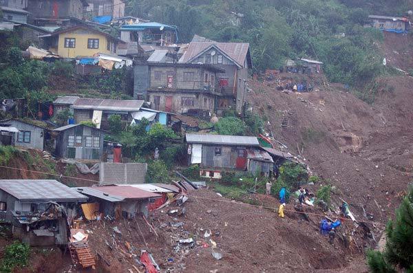
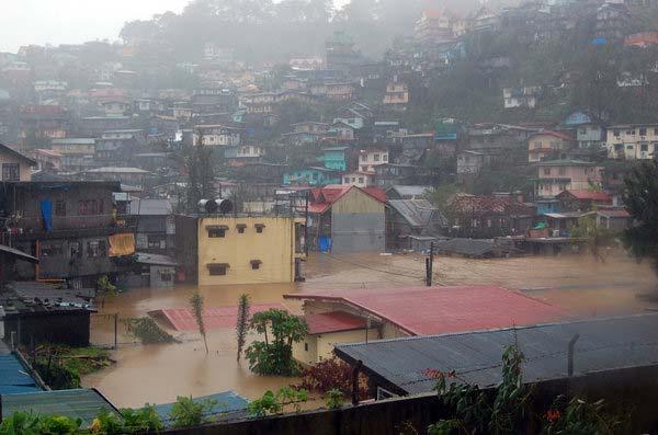
48 EMI P age

49 Province of Cagayan and the Municipalities of Amulung and Enrile Socio economic Profile With an area of square kilometers, Cagayan Province has a population of 1,191,000 as of 2010 with an estimated 13% residing in its capital, Tuguegarao City. It is comprised of 28 municipalities including the third class municipalities of Amulung and Enrile. The two municipalities have population of 44,367 and 29,719 respectively as of Cagayan relies heavily on its agricultural sector, which accounts for 73.5% of the total employment in the province. The agricultural products are mostly corn, tobacco, rice and vegetables that are water intensive and are visible near river banks. Prominent also are fishery products, as the province has a significant coastline. Accounting for the remaining workforce of 22.3% is the service sector, which includes the tourism sector, and 4.2% from the industrial sector. (Department of Agrarian Reform Cagayan Provincial Office, 2011) Hazard Environment In the Municipality of Enrile alone, the region s major supplier of maize, there are hectares of corn planted on low lying areas near the Cagayan River. This agricultural practice is prevalent in other municipalities that are within the passageway of the rivers such as Amulung. The river flows from the nearby Province of Nueva Vizcaya in the south and the bordering mountains, traversing Cagayan going northwards to the Pacific Ocean. For this reason, Amulung and Enrile encounters extreme Figure 3: Cagayan River and its Tributaries. Source: PSWDO flooding during typhoons. The Cagayan River and its tributaries, namely, Pinacanauan Zinundungan, Chico, Pata, Abulug, Buquey, Cabicungan and Matalag are subject to extensive flooding during monsoon season. To add to the predicament, the province is a potential pathway of powerful typhoons such as Juan and Pepeng. The province also has five active volcanoes located in the municipalities of Gonzaga and Calayan Island in the north. Eruption from any of these volcanoes might trigger earthquakes and tsunamis that will affect the coastal municipalities. EMI P age
50 Impact of Recent Disasters Volcanic eruption has not occurred in recent times in Cagayan, leaving floods as the worst hazard to hit the province and the two municipalities. In October 2009, Typhoon Pepeng wreaked havoc, causing Php 1,848,496, in damages, with the agricultural sector taking most of the blow. It also affected 181,213 persons or 15% of the population. Fortunately, there were no fatalities and persons missing. Typhoon Juan, which occurred in October 2010, did not provide similar statistics with only 6 fatalities and 1 missing. However, 25% of the population was affected but registered only Php 771 million in damages, again mostly to its agricultural sector. The Inter tropical Convergence Zone that followed a month after, caused widespread flooding that rendered large portions of agricultural lands under water. During the March 11, 2011 earthquake and tsunami in Fukushima Japan, waves between 0.3 to 0.7 meters reached the coastal areas of the province. References 1) Wikipedia: Accessed: February 17, ) Tripod: Accessed: February 17, ) Cagayan Provincial Disaster Risk Reduction Management Council: Accessed 18, ) Provincial Social Welfare and Development Office in Cagayan, DRR Strategies PowerPoint Presentation. 5) Department of Agrarian Reform Cagayan Provincial Office: Accessed: April 11, EMI P age

51 Province of Laguna General Profile of Laguna The Province of Laguna is located directly southeast of Metro Manila, surrounding the south and eastern parts of Laguna de Bay. It is bordered to the north by Rizal province, to the east and southeast by Quezon province, to the south and south west by Batangas, and to the west by Cavite. Its total land area is 1,823.6 square kilometers. The capital city is Sta. Cruz. The southern and eastern municipalities are largely agricultural based economies, while the northern municipalities and cities, due to proximity to Metro Manila, are industrialized. Figure 4: Political map of Laguna Socio Economic Profile of Laguna Laguna is currently governed by the Hon. Emilio Ramon P. Ejercito. There are four congressional districts in Laguna. There are four cities and one special city zone (Los Baños) in the province. There are 26 municipalities. Table 2 summarizes the list of municipalities and cities in Laguna. EMI P age
52 Table 2: Cities and Municipalities in Laguna Municipality Income Class Population (2007) Alaminos 3 rd class 40,380 Bay 3 rd class 50,756 Cabuyao 1 st class 205,367 Calauan 3 rd class 54,248 Cavinti 4 th class 20,469 Famy 5 th class 13,577 Kalayaan 5 th class 21,203 Liliw 4 th class 32,727 Los Baños 1 st class 98,631 Luisiana 4 th class 19,255 Lumban 3 rd class 28,443 Mabitac 5 th class 17,608 Magdalena 5 th class 20,204 Majayjay 4 th class 23,681 Nagcarlan 3 rd class 57,070 Paete 4 th class 24,696 Pagsanjan 2 nd class 35,944 Pakil 5 th class 20,242 Pangil 4 th class 23,421 Pila 4 th class 44,227 Rizal 5 th class 15,459 San Pedro 1 st class 281,808 Santa Cruz 1 st class 101,914 Santa Maria 4 th class 26,267 Siniloan 3 rd class 34,877 Victoria 4 th class 33,829 Biñan City 1 st class city 262,735 Calamba City 1 st class city 360,281 San Pablo City 1 st class city 237,259 Santa Rosa City 1 st class city 266,943 Source: NSO EMI P age


53 The following maps show the spatial distribution of the Laguna census. Figure 5: Municipal income classes in Laguna Figure 6: Population distribution in 2007 EMI P age


54 Figure 7: Population density in Laguna Figure 8: Population density and income class in Laguna EMI P age
55 Municipality of Mabitac The Municipality of Mabitac is a fifth class municipality 3. In 2007, it had a population of 17,608, distributed in 15 barangays. The population density of Mabitac is approximately persons per square kilometer. Table 3 summarizes the barangays and their respective population in Table 3: Barangays and Population (2007) in Mabitac, Laguna Barangay Population Amuyong 531 Lambac (Poblacion) 1,518 Lucong 1,100 Matalatala 2,571 Nanguma 2,321 Paagahan 3,229 Bayanihan (Poblacion) 505 LibisngNayon (Poblacion) 771 Maligaya (Poblacion) 270 Masikap (Poblacion) 535 Pag Asa (Poblacion) 953 Sinagtala (Poblacion) 779 San Antonio 1,216 San Miguel 771 MABITAC 17, 608 The Commission on Audit (COA) reports that in , the income of Mabitac is PhP 32, 437, It spent PhP 30, 958, , giving it a net income of PhP 1, 479, Municipality of Pila The Municipality of Pila is a fourth class municipality. In 2007 it has 44, 227 people 6 in 17 barangays. The population density of Pila is approximately 1, persons per square kilometer. Table 4 summarizes the barangay and population. Table 4: Barangays and Population (2007) in Pila, Laguna Barangay Population Aplaya 3,253 BagongPook 2,752 Bukal 591 Bulilan Norte (Poblacion) 2,112 Bulilan Sur (Poblacion) 3,271 Concepcion 931 Labuin 3, Commission on Audit Annual Financial Report: Local Governments (Volume III) 6 EMI P age
 reports that in 2008 7, the income of Pila is PhP 11, 661, 854.60. It spent PhP 47, 281, 384.63, giving it a net loss of PhP 35, 619, 530.03.")
56 Barangay Population Linga 3,542 Masico 1,994 Mojon 714 Pansol 1,993 Pinagbayanan 5,011 San Antonio 3,315 San Miguel 866 Santa Clara Norte (Poblacion) 2,491 Santa Clara Sur (Poblacion) 5,691 Tubuan 1,933 PILA 44,227 The Commission on Audit (COA) reports that in , the income of Pila is PhP 11, 661, It spent PhP 47, 281, , giving it a net loss of PhP 35, 619, Hazard Environments of Laguna The province of Laguna is exposed to several hazards: landslides. flooding, volcanism, liquefaction and Figure 9: Physical Map of Laguna 7 Commission on Audit Annual Financial Report: Local Governments (Volume III) EMI P age
 Figure 10 shows the distribution of volcanoes in the Philippines 8.")
57 Figure 9 shows the physical map of Laguna. From the map it can be seen that the municipalities adjacent to Laguna de Bay have low elevation, making them susceptible to floods. Figure 10: Volcanoes in the Philippines (inset added by author) Figure 10 shows the distribution of volcanoes in the Philippines 8. It can be seen that there are two active volcanoes near the province: the San Pablo Volcanic Field 9 and Mount Banahaw 10. Figure 11 below shows a liquefaction map of the Philippines 11. The inset shows the Laguna province area where there is a possibility of liquefaction = 10 of the philippines 11 EMI P age
58 Figure 11: Areas susceptible to liquefaction (inset added by author) The northeastern area of Laguna is susceptible to earthquake induced landslides, as shown by Figure EMI P age

59 Figure 12: Landslide susceptibility map (inset added by author) Municipality of Mabitac Figure 13 shows the topography of the Municipality of Mabitac. It can be seen that the central region of the municipality is a low lying valley. The western region is high relief. The low lying areas make it exposed to flood hazards. From Figure 12 above it can be seen that the region is exposed to liquefaction as well as earthquake induced landslides. EMI P age


60 Figure 13: Mabitac Physical Map Municipality of Pila Figure 14: Physical map of Pila EMI P age

61 Figure 14 shows the physical terrain of Pila. It can be seen from the above figure that the entire town has low elevation, and coupled with its proximity to Laguna de Bay, it is exposed to flood hazards. It is also susceptible to liquefaction (figure 11). Impacts of Recent Disasters of Laguna The most recent disaster that affected the Province of Laguna is flooding due to the Typhoons Ondoy and Santi. Figure 15 below shows the flood levels in the cities and municipalities surrounding Laguna de Bay 13. Figure 15: Flood levels during Typhoon Ondoy and Pepeng It can be seen from the map that most of the barangays affected by flood were submerged at knee level water. Due to flood waters, more than one thousand families were evacuated 14. According to the Laguna Provincial DRRMP final report the flood water lasted almost four months Oct 09%20Flood%20Water%20Levels%20 %202%20of%203%20 %20A3.pdf 14 cbnnews.com/nation/regions/09/26/09/1000 families evacuated laguna EMI P age
62 Province of Sorsogon Socio economic Profile of Sorsogon Sorsogon is a second class province and has a total land area of 214, hectares comprising 12.1 percent of the total land area of the region. According to COA 2008 report, the province has an average annual income of 740,771, The province of Sorsogon has 15 municipalities and 1 city namely: Municipalities 1. Barcelona 6. Gubat 11. Prieto Diaz 2. Bulan 7. Irosin 12. Santa Magdalena 3. Bulusan 8. Juban 13. Casiguran 4. Castilla 9. Matnog 14. Magallanes 5. Donsol 10. Pilar 15. Bacon City Sorsogon City Demography As of the 2007 census, the province had a total population of 709,673. In terms of distribution of the municipal population, Bulan has the biggest population followed by Pilar. The municipality of Barcelona has the smallest population. Economy Sorsogon is set to participate in the developing growth corridor of Bicol and take advantage of its position as Luzon s link to the Visayas. The fertile earth produces rice, coconuts, abaca, and coffee. The hills and mountains are also sources of limestone, coal, pumice, pumicite, and white clay. Sorsogon s location on the tail of the southern Luzon and skirting the deep waters of the Pacific Ocean gives the province a bounty of aquamarine resources. The province also has an abundance of technically skilled, highly trainable labor force. The province is easily accessed through the Maharlika Highway System, and buses plying the Manila Tacloban or Manila Davao route carry commuters all the way up to Matnog and are ferried across to Allen in Northern Samar. A network of secondary roads also links the other municipalities together. There are two airstrips in Sorsogon although nearby Legaspi City Airport is the usual air link to the province. There are 3 major ports and 6 municipal ports that provide sea borne access to the province. Matnog is a major link between Luzon and Samar Islands, while the port in Bulan moves cargo and passengers between Sorsogon and Masbate. Reliable telecommunications link the province to the rest of the country and to the world. The province is a major source of geothermal power to the Luzon Grid and is amply supplied with electricity while local water districts supply water for domestic and industrial use. Nineteen private and government banks provide the province with a vibrant banking industry. Resource based industries are the most promising prospects for potential investors. Gifts and handicraft manufacture, food processing, brick making and pottery, seaweed production and fiber EMI P age
63 processing are the most encouraging industries in the province. The province also holds a big potential for tourist development. Natural wonders, such as Mount Bulusan and Bulusan Lake, and Rizal Beach have traditionally attracted visitors to the province. However, the province also offers pristine beaches, cold and hot springs, isolated island getaways, caves and waterfalls. Droves of tourists are now pouring into the province attracted by the gentle whale sharks or the butandings that feed off the coast of Donsol. The local government is promoting the development of tourist facilities in destinations such as Pinaculan Island, the Bulusan National Park, the Rizal Beach Tourism Estate, and, of course, the Donsol Whale Shark Watching area. The province reputedly produces the best abaca hemp in the entire region, a matter of great importance in a province that supports a number of abaca based industries. Sinamay cloth weaving and abaca fiber slippers are chief household industries. Socio cultural The people of Sorsogon are Bicolanos and generally speak the Bicol language. However, close proximity to the Visayan island of Samar has given the dialects spoken in the province a peculiarly Visayan tone and vocabulary, which probably indicates a mixture of the Waray and Bicol languages. Most Sorsogon Bicols can speak English and Filipino fluently. Sorsogon s people are mostly farmers and fishermen engaged in the cultivation of coconut, abaca and rice. Sorsogon Bay is one of the great prides of the Bicol region. It is blessed with mangrove areas rich with a variety of shrubs, vines and palms. The bay abounds with fin fishes, crabs and shellfishes. Because of the bay s natural abundance, it has continuously attracted migration of fishers from other fishing villages and merchant capitalists who invest in aquaculture and export of shellfish. Festivals are also celebrated in the province to showcase the cultural and historical activities of the region. Kasanggayaan, Pili festival, Padaraw, Butanding Arribada, Ginubat and Hin ay Festival are some of the festivals. Municipality of Juban Juban is a 4th class municipality in the province of Sorsogon, Philippines. Based on the 2000 census, it has a population of 26,848 people in 4,957 households. According to COA 2008 report, the municipality has an average annual income of 44,888, Juban is politically subdivided into 25 barangays namely: 1. Anog 9. Carohayon 17. North Poblacion 25. Tublijon 2. Aroroy 10. Catan agan 18. South Poblacion 3. Bacolod 11. Catanusan 19. Puting Sapa 4. Binanuahan 12. Cogon 20. Rangas 5. Biriran 13. Embarcadero 21. Sablayan 6. Buraburan 14. Guruyan 22. Sipaya 7. Calateo 15. Lajong 23. Taboc 8. Calmayon 16. Maalo 24. Tinago The municipality is predominantly engaged in agricultural activities. Their major crops include rice, coconut and banana. EMI P age

64 There are two (2) private secondary schools and (4) public secondary schools in Juban. Elementary schools are greater in number; there are 25 public schools and 1 private. Health facilities are also present in the municipality, 25 barangay heath centers and 28 barangay day care centers. There is a total of 16 health personnel. Municipality of Irosin Irosin is a 3rd class municipality in the province of Sorsogon, Philippines. It is the only land locked municipality of the province. According to the 2000 census, it has a population of 45,507 people in 8,639 households. According to COA 2008 report, the municipality has an average annual income of 58,405, Irosin is politically subdivided into 28 barangays namely: 1. Bagsangan 9. Cawayan 17. Mapaso 25. San Pedro 2. Bacolod 10. Cogon 18. Monbon 26. Tabon Tabon 3. Batang 11. Gabao 19. Patag 27. Tinampo 4. Bolos 12. Gulang Gulang 20. Salvacion 28. Tongdol 5. Buenavista 13. Gumapia 21. San Agustin (Pob) 6. Bulawan 14. Santo Domingo 22. San Isidro 7. Carriedo 15. Liang 23. San Juan (Pob) 8. Casini 16. Macawayan 24. San Julian (Pob) The municipality is primarily engaged in agricultural activities. Hazard Environment The Province of Sorsogon lies between 124 <> and east longitude and from 12 0 to 13 0 north latitude. It is the southernmost province in the island of Luzon. Except for its overland link with the province of Albay to the north, it is completely surrounded by water. To the east lies the vast Pacific Ocean; the turbulent San Bernardino Strait separates it from the Samar provinces in the south; and it is bounded on the west by the Burias and Ticao Passes of the South China Sea. The province is divided into two (2) congressional districts, composed of 14 municipalities, one component city which is the provincial capital, and 541 barangays. Except for lrosin, all the municipalities including the City of Sorsogon are located along coastal zones, sites of beautiful beaches, with great tourism potential. EMI P age
65 Topography Sorsogon province is characterized by an irregular topography mountains sprawl over the northeast, southeast and west portions of the province. These mountains slope down to small valleys and plains. Mount Bulusan is its tallest peak as it towers 1,560 meters above sea level. It is an active volcano located at the southeastern part of the province. Major water bodies include Sorsogon Bay, Bulusan Lake, and the rivers of Cawayan in Sorsogon; Putiao in Pilar; and Cadac an in Irosin and Juban. Climate The province is well within the country's typhoon belt, influenced by the northeast and southeast monsoons, ten months a year. The northeast monsoon occurs from October to March while the southeast monsoon prevails from June to September. Summer lasts for only two months when favorable North Pacific Trade winds come during April and May. Under the corona climate classification system, the province falls under type II; a type of climate with no dry season but with very pronounced maximum rain period from November to January. Rainfall Barometer readings on annual rainfall give an average of 2,811.0 mm. The wettest month is November at mm and May has the least rainfall at mm. Temperature Mean annual temperature stands at 26.4 C to a high of 30 C. February is the coolest month and May is the warmest. Drainage Natural basins in mountain ranges collect water which then flow to major river channels and their tributaries downstream, empty into surrounding water bodies such as the Pacific Ocean, San Bernardino Straitl Burias and Ticao Passesl and Sorsogon Bay. Serving as a natural drainage system of the area are 55 rivers and 31 major creeks and streams, with Cawayan River yielding the highest daily discharge of 3,040 cubic meters. Man made dikes, however, are found in the Irosin Juban valley. which serve as irrigation, drainage, and river control facilities. Existing Land Use The province is predominantly agricultural, owing to its rugged terrain; coconut trees dominate the provincial landscape in virtually all of its component municipalities. Lowland areas are irrigated and irrigable areas, which are largely found in the Juban Irosin Valley alongside the Cadac an River, the Donsol Pilar boundary, and, along rivers and tributaries in the towns of Bulan, Matnog and Gubat. Rice lands are, likewise, located in coastal areas next to mangroves, brackish water fishponds and some urban centers. There are a few areas devoted to cultivated annual crops, such as corn and cassava, including upland rice and these are mostly found near the Pilar Castiila boundary. In coastal EMI P age
66 Final Report Annexes zones, mangroves are being utilized as brackish water fishponds. Forest lands are still found in the northern portion of the province surrounding the BACON MANITO Geothermal Production Field in the southern part of Castilla, around Mt. Bulusan National Park, and the Mt. Bintacan Watershed area. Areas for water sources are abundant, but entail huge costs for bringing the water to communities. Quality of Physical Environment The physical environment plays an important factor in the development of the province. Like other provinces of the Bicol Region, Sorsogon lies along the typhoon belt, getting the "wrath" of these howlers at least six times a year. Another is the existence of Bulusan Volcano, which greatly affects the province, particularly the neighboring towns of Bulusan, lrosin,,juban and Casiguran. Twenty six (26) barangays lie along the volcano's danger zones. During the occurence of these natural calamities, the most affected are the vulnerable groups, especially women and children which are found mostly in the rural areas. Bulusan Vocano Profile Source: PowerPoint Presentation of Mayor Jimmy J. Fragata, April 5, 2011 Location and Accessibility Bulusan Volcano is the southernmost volcano in the northwest trending volcanic belt known as the Bicol Volcanic Chain. It lies near the central part of Sorsogon province at the southern portion of Bicol Peninsula. It is located about 70 km BE of Mayon Volcano and approximately 250 SE of Metro Manila. Bounded on the East by San Bernardino Strait, on the North by Sor80gon Bay and on the EMI P a g e
67 West and South by intermediate zones of fairly flat terrain punctuated by highly dissected volcano mountains. The main access to Bulusan is via Daang Maharlika, a national highway traversing the Bicol Peninsula. Geologic Features The volcanic deposits that comprise Bulusan Volcano, Sharp Peak, Mt. Jormajan and the encompassing Caldera deposits were included in the Polangui Volcanics classified in geologic mapping. Bulusan is a stratavolcano and dome complex located at the NE floor of the caldera. The dominant rocks are two pyroxene andesite in Bulusan and dacite associated with caldera. Based on evidence and preliminary data, a calderagenic eruption occurred about 40,000 Y.B.P. this eruption reated a volcanic depression which now measures about 200 m in depth an 11 km in diameter. The strongest eruption recorded was in 1912 but no data available as to the extent of damage. In March 2006 the Bulusan Volcano was reactivated, followed by an alert level 1 volcanic eruption in May Then, an alert level 2 volcanic eruption the following month, June There were series of volcanic ashfalls and eruptions up to the present, The most recent was on March 21, Hazard Environment of Juban and Irosin The Municipality of Juban is a town centrally located in the province of Sorsogon with a distance of 23 kilometers from Sorsogon City. Like other towns of the province it is not spared from the wide range disaster like typhoons, quakes, the danger of volcanic eruptions and flashfloods. Irosin is considered to be one of the most high risk municipalities in the Bicol Region with combined weather, volcanic and earthquake related risks. The municipality is usually affected by tropical storms that pass through the region. Irosin is also listed among the 48 municipalities in the region which are considered to be in a geologically hazardous area highly prone to landslides and flooding. And from March 2006 up to October of 2007, Mount Bulusan s volcanic activities threatened the lives of people in Irosin and other municipalities in Sorsogon. Numerous explosions deposited undetermined volume of ash and volcanic debris at the slopes of the volcano. At the same period, flash floods and mudflows affected 18 barangays in Irosin distressing a total of 894 families or 3,991 individuals. Bulusan Volcano again had ten episodes of ash explosion from November to December last year which caused ash fall and lahar flows in many barangays of Irosin. These volcanic activities resulted to the temporary displacement of 231 families or 1,014 individuals last November. EMI P age

68 Impact of Recent Disasters Sorsogon The recent Honshu Japan Earthquake last 11 th March 2011 (Philippine time) affected the provinces facing the Pacific Ocean and Sorsogon province was one of these. The first tsunami was expected to arrive between 5:00PM to 7:00 PM and may not always be the largest and these waves may continue for hours. The concerned public was advised to be on alert for unusual waves. They were also advised to stay away from the shoreline during this period and should not go to the coast to watch the tsunami. Also, the recent lahar flow which transpired on the 15 th March 2011 was brought about by heavy rains and directly affected the five (5) municipalities of Sorsogon namely Juban, Casiguran, Bulusan, Irosin and Barcelona. In addition, these towns are within the Bulusan Permanent Danger Zones set by PHIVOLCS. This phenomenon resulted to great economic losses in the province since Sorsogon is predominantly agriculture. Bulusan Volcano Danger Zones Figure 16: Major Volcanic Eruptions in 2010 and 2011 EMI P age


69 Table 5: Record of Mt. Bulusan eruptions ( ) Source: PowerPoint Presentation of Mayor Jimmy J. Fragata, April 5, 2011 Figure 17: Photos of Major Eruptions of Mt. Bulusan Source: PowerPoint Presentation of Mayor Jimmy J. Fragata, April 5, 2011 Municipality of Junab and Irosin The recent lahar flow was observed in municipalities of Juban and Irosin last 15 th March 2011 brought about by heavy rains that transpired the night before. According to NDRRMC report, three (3) houses were partially damaged and covered by mudflow. Fifty (50) houses were reached and affected by mudflow. EMI P age
70 Table 6: Affected Population as of 12:00 NN Municipality Barangay Evacuated Remarks Families Persons IROSIN Patag Relief goods distributed Bagsangan Relief goods distributed Tabon Tabon Relief goods distributed Monbon Moved to neighboring houses, bridge in Bliss coved in lahar Bolos 1 3 Flooding of access toad to Guruyan, Juban. Houses collapsed/washed out. Relief goods distributed (sponsored by Louis de Marillac Sorsogon & Irosin Macawayan Rice field flooded Gulang gulang Damaged to water pipe reported Subtotal JUBAN Anog Evacuated last night. Decamped in Guruyan 7 35 the afternoon due to improved Sipaya weather condition Catanusan Calateo Subtotal GRAND TOTAL Source: NDRRMC Report. Accessed on March 15, 2011 Prior to lahar flow that transpired last March 15, 2011, there was a Bulusan volcano ash ejection on February 21, 2011 at 9:12 AM. The event was recorded as explosion type earthquake lasting for about nineteen (19) minutes and was accompanied by a rumbling sound which was heard up to ten (10) kilometers away in the town of Juban, Sorsogon. Figure 18: Bulusan Volcano February 21, :12 AM ash ejection EMI P age
71 Photo courtesy of Joel Alarcon The explosion produced a greyish ash column that rose to a height of about three (3) kilometers above the summit before drifting to the southwest. Field investigations and reports confirmed the presence of ash deposits in the following areas: 1) Municipality of Irosin, Sorsogon: Barangays Casini, Salvacion, Buenavista, Monbon, 2) Tinampo, Cogon, Gulang Gulang and Bolos. 3) Municipality of Juban, Sorsogon: Barangays Sankayon and Puting Sapa 4) Municipality of Magallanes, Sorsogon: Barangay Lapining 5) Masbate: Masbate City and Malinta 6) Municipality of Bulan, Sorsogon: Barangays Cadandan, Palali, Quirino, San Francisco, 7) Sumagongsong, Aquino, Bulan Proper, Fabrica, Del Pilar, San Roque, San Isidro, Gate and 8) Trece. According to PHIVOLCS, the source of activity of Bulusan Volcano is hydrothermal and shallow. PHIVOLCS also prohibits entry to the 4 kilometer radius Permanent Danger Zone (PDZ) since the area is at risk to sudden steam and ash explosions. Residents in the northwest and southwest sectors of the volcano are reminded to take precautions against ashfalls due to the prevailing wind direction. Civil aviation authorities is advised to warn pilots to avoid flying close to the volcano s summit as ejected ash and volcanic fragments from sudden explosions may be hazardous to aircraft. If possible aircraft should avoid flying on the western side of the volcano as volcanic debris are likely to be carried in this direction by the prevailing winds. Furthermore, people living near valleys and river/stream channels were advised to be vigilant against sediment laden stream flows and lahars in the event of heavy and prolonged rainfall. Alert status of Bulusan. REFERENCES Draft Provincial Physical Framework Plan, Province of Sorsogon. Provincial Development Council. June Juban Disaster Management Plan. Undated. Oplan Bulkan Bulusan. Undated. Sorsogon Provincial Disaster Protocol Annual Municipal Disaster Risk Reduction and Management Plan and Proposed Programming of the Municipal Disaster Risk Reduction and Management Fund Accessed on February 27, /profile.htm EMI P age
72 IV. Field Investigation Reports Field Investigations (FIs) were conducted in four provinces and eight municipalities. This section provides: 1) narrative on the activities conducted, 2) the DRRI ranking results, and 3) initial findings during the FIs, in the following order: 1) Province of Benguet 2) Province of Cagayan 3) Province of Laguna 4) Province of Sorsogon This will be followed by the List of Participants in the same order. EMI P age

73 Field Investigation Report Province of Benguet and the Municipalities of Tublay and Atok March 9 March 11, 2011 Submitted by: Mr. Jose Mari Daclan, Project Manager, EMI Mr. Mariño Deocariza, LUP Expert Mr. Jerome Cruz, Provincial Coordinator EMI P age
74 Field Investigation Team and Provincial Contacts The EMI Field Investigation Team was composed of Mr. Jose Mari Daclan, Mr. Mariño Deocariza, and Mr. Jerome Cruz. The team prepared Question Guides and Workshop Kits for the participants. Accompanying the team during the LGU visits and workshops was Mr. Joseph Alviar, the field monitor of WFP. The Provincial Planning and Development Office, headed by Engr. Tuho Chapdian arranged for the invitations of the participants, venue and caterer for the three workshops. He was assisted by Ms. Rose Badival, of the PPDO, who personally informed the mayors of Tublay and Atok on the CNADPR workshops. Ms. Badival and Engr. Mike Epie, of the PPDO, assisted the team during the workshops in the two other municipalities. Field Investigation Agenda The workshop has two particular objectives: 1. To undertake an inventory and review of the existing capacity development initiatives and practices in DRRM at the provincial level down to the two selected municipalities, and; 2. To identify gaps and recommend areas for intervention Day Time Activity March 8, am 5pm 5pm 6pm Team Preparations and Travel to Baguio City Arrival; Preparatory Meeting with Benguet PPDO March 9, am 4pm Benguet Provincial DRRI Workshop and Key Informant Investigation March 10, am 9am 9am 4:30pm Travel to Municipality of Tublay Tublay Municipal DRRI Workshop and Key Informant Investigation March 11, am 9am 9am 4:30pm Travel to Municipality of Atok Atok Municipal DRRI Workshop March 12, am 4pm Travel back to Manila EMI P age


75 Summary Field Investigation Activities Arrival and Preparatory Meeting/ Briefing o The Field Investigation Team arrived in Baguio City at around 3:30 PM in the afternoon of March 8, 2011 for a three day Field Investigation. o A short preparatory meeting was held at the Benguet Provincial Planning and Development Office in the Municipality of La Trinidad. Ms. Rose Badival and Engr. Tuho Chapdian briefed the visiting team on the arrangements made for the workshops. Also, Mr. Deocariza interviewed Engr. Chapdian on the Legal and Institutional Arrangements on DRM in Benguet and handed out forms for them to answer. Figure 19 Benguet Provincial DRRI Workshop Figure 20 Gov. Nestor Fongwan giving the closing remarks Benguet Provincial Workshop o The Workshop was held in the Provincial Capitol Building March 9, 2011 o It was attended by more than 50 participants from the regional and provincial agencies headed by the provincial government. Worth noting is the presence of the Provincial Governor Hon. Nestor Fongwan, who gave the closing remarks, and Vice Governor Hon. Crecencio Pacalso, who also heads the Provincial Legislative Council or Sangguniang Panglalawigan. Mayor Hon. Peter Albos and Vice Mayor Hon. Marson Lay At of Atok Municipality also attended the Workshop o A presentation on current and past DRR/DRM related activities in the province was given by Mr. Ronald Villa of the Office of Civil Defense Cordillera Administrative Region. o The participants were divided into three groups to grade the DRRI answer sheets. Figure 21 Participants after the workshop Figure 22 (L R) Mr. Jom Daclan (EMI), Mayor Ruben Paoad, Mr. Joseph Alviar (UNWFP), and Mr. Mariño Deocariza (EMI) during the courtesy call to the Mayor. EMI P age


76 Tublay Municipal Workshop o The Field Investigation Team, together with Mr. Joseph Alviar of the UNWFP, had a courtesy call with the Municipal Mayor of Tublay, Hon. Ruben Paoad to discuss the WFP Capacity Needs Assessment Project. o The Workshop was held in the Municipal Hall Building on March 10, 2011 o It was attended by more than 45 participants from the municipal offices and barangay representatives. gave the welcoming and closing remarks for the workshop o Mayor Ruben Paoad gave the welcoming and closing remarks for the workshop. o The workshop participants were again divided into three groups for the DRRI ranking. o While one of the group was still finishing answering the DRRI forms, Mr. Deocariza and Mr. Cruz conducted Key Informant Interviews with the Municipal Social Welfare and Development Officer. Figure 23 Participants during the Tublay Municipal Workshop Figure 24 Atok Municipal Workshop Participants Atok Municipal Workshop o The travel to Atok Municipality took almost two hours by way of the Halsema Highway. On the way, the Field Investigation Team was able to see and pass through the sections of the highway affected by landslides and undergoing repairs. o The Vice Mayor of Atok Municipality Hon. Marson Lay At was the one who welcomed the Field Investigation Team, the Mayor was unable to join the Municipal Workshop as he had an appointment with Gov. Fongwan on the same day. o The Workshop was held at the legislative hall of the municipal capitol building. It was attended by more than 40 participants from the municipal government offices and representatives from the different barangays of Atok on March 11, 2011 Figure 25 Highway repairs due to Landslides on the Halsema Highway Figure 26 Staff from the PPDO answering the Key Informant Interview Questionnaire EMI P age
77 o Mr. Deocariza and Mr. Cruz also conducted Key Informant Interviews and gathered pertinent documents Challenges Encountered Local knowledge on DRR/DRM and related terms were limited. The Field Investigation Team had to give a brief backgrounder on terms such as Hazards, Vulnerability, and Resiliency. There was a problem with communication as the workshop participants could not understand some of the terms used because they were more comfortable using Ilocano, English and other local dialects rather than Tagalog. Lack of soft copies for important documents such as Executive Orders, Provincial/Municipal Ordinances, and plans meant that a lot of time was spent photocopying these documents for the Field Investigation. The geographical distance between municipalities made travelling to some of the municipalities a long drive almost two hours and you had to pass through some landslide damaged portions of the Halsema Highway to get to the municipalities. Data for the Initial Findings Disaster Risk Reduction Resiliency Indicators Results Legal and Institutional Processes Indicator 1. Effectiveness of Legislative Framework Indicator 2. Effectiveness of Institutional Arrangements Awareness and Capacity Building Indicator 3. Training and Capacity Building Indicator 4. Advocacy, Communication, Education and Public Awareness Critical Services and Infrastructure Resiliency Ave. Score BENGUET PROVINCE Ave. Score Key Area Ave. Score ATOK Ave. Score Key Area Ave. Score Indicator 5. Resiliency of Critical Services Indicator 6. Resiliency of Infrastructure Emergency Management and Response Planning TUBLAY Ave. Score Key Area EMI P age
78 Indicator 7. Emergency Management Indicator 8. Resource Management, Logistics and Contingency Planning Development Planning, Regulation and Risk Mitigation Indicator 9. Hazard, Vulnerability and Risk Assessment Indicator 10. Risk Sensitive Urban (and Rural) Development and Mitigation AVERAGE SCORE LGU EMI P age
79 DRM Gaps, Recommendations and Potential WFP Intervention Benguet Province INDICATOR RATING STRENGTHS GAPS RECOMMENDATIONS Potential WFP Areas 1 Effectiveness of Legislative Framework 3 Moderate DRRM law has been adopted; EO/AO issued by Governor DRRM Council in place EO creating DRRM Office signed Feb 2011 Funds allocated for DRM Internal budget is augmented with supplemental budget when not enough Province has the capacity to tap outside resources EO needs to be translated to ordinances and policies for other agencies and department DRM awareness of officials is adequate, but not at the community/household level Minimal funds for DRRM. Insufficient to cover all DRRM activities. May not be enough for large magnitude disasters and extended rescue operations Not all policy requirements of DRRM Act have been complied with Legislative briefing on DRRM DRRM Act needs to be translated to policies and ordinances for various agencies and department Info dissemination, seminar on DRRM / DRRM Act / DRRM sound practices EMI P age
80 INDICATOR RATING STRENGTHS GAPS RECOMMENDATIONS Potential WFP Areas 2 Effectiveness of Institutional Arrangements 3 Training and Capacity Building 3.3 Moderate 2.5 Low Good coordination among different provincial and local agencies, NGOS and communities are actively involved in DRR Several agencies e.g. DSWD, DOH, PNP, etc. are well prepared for disaster Initial stages of transition from PDCC to PDRRMC Disaster Response Trainings undertake Funding is readily available Training of trainors conducted No full time personnel to man the DRRMO. The provincial government is saddled by personnel budget ceiling on hiring. Overlapping responsibilities in terms of info management No incident command system in place No centralized disaster information management system Decision making is highly centralized, should be improved with the creation of the DRRM Office The old PDCC meets irregularly, adhoc meetings Lack of comprehensive DRRM capacity building program DRRM trainings not regularly conducted and sustained Establish appropriate institutional/organizational structures in accordance with RA Formulation of DRRM Capacity Building Program for Benguet. Establish Regional/Provincial DRRM Training Center TA from WFP TA from WFP/OCD/Provincial Government EMI P age
81 INDICATOR RATING STRENGTHS GAPS RECOMMENDATIONS Potential WFP Areas 4 Advocacy, Communication, Education and Public Awareness 2.3 Low There are trainings for the rescue team Yearly IEC programs on preparedness and response. Initiatives during fire/disaster prevention months Awareness on disasters is high due to recent disasters Various modes used to disseminate DRM messages (radio, posters, meetings, Limited funding for DRRM capacity building (P200,000 per year), results to limited range of DRRM trainings offered. Lack of training for other DRRM competencies like early warning, IEC, Hazard Mapping, ICS, Basic Life support for all sector and Advance Life Support (ACLS) and other special trainings Limited nos. of manpower trained No IEC program / awareness raising campaign on DRRM Moderate level of DDRM awareness for policy makers, managers and professionals Low level of DRRM awareness among the public no formal advocacy strategy/program for DRRM Formulation of DRRM IEC Program for the Province TA from WFP/NGOs EMI P age
82 INDICATOR RATING STRENGTHS GAPS RECOMMENDATIONS Potential WFP Areas 5 Resiliency of Critical Services 2.7 Moderate community gatherings) Initial system in place for early warning and DRM messages Advocacy and awareness campaigns integrated into environmental programs Coordination with specific sectors (mining and agriculture) in place, media (esp. Radio) involved in information dissemination Livelihood programs available from national and provincial government, NGOS, etc. Presence of water delivery services (trucks) in 5 Inadequate supply of water (water shortage) even during normal conditions, water shortage during summer Inadequate capacity of provincial and district hospitals in terms of medical equipment, Install system to ensure that emergency services and critical services are adequate, resilient in time for emergencies. Strengthen medical services and capacity to reach far flung areas TA/FA from WFP/DOH/Private Hospitals/Clinics EMI P age
83 INDICATOR RATING STRENGTHS GAPS RECOMMENDATIONS Potential WFP Areas 6 Resiliency of Infrastructure 2.7 Moderate municipalities Volunteer nurses may be tapped during emergencies and disasters There are available stocks of medicine Damage assessment conducted by the Provincial Engineering Office and PPDO The engineering group has the manpower, resources Inadequate supply of medicine during major disasters Several areas not accessible to critical emergency services Provincial and district hospitals may not be wellequipped for major emergencies. The Provincial Hospital lacks trauma unit, patients are brought to Baguio General Hospital for advance medical attention There are stocks of medicine but may not be enough for a major disaster; Poor resiliency of infrastructure in Benguet. The province sustained massive damages to roads, power supply, water supply, other Landslide Mitigation Plan for Benguet Province Infrastructure vulnerability assessment Retrofitting program for critical structures TA/FA from WFP/Provincial Government/MGB/Local experts EMI P age
84 INDICATOR RATING STRENGTHS GAPS RECOMMENDATIONS Potential WFP Areas 7 Emergency Management 2.8 Moderate capacity to construct temporary infrastructure. Province purchased heavy equipment and rescue equipment LGUS have capacity to restore functionality of infrastructure systems in case of disruption. Blocked roads are cleared faster by LGUS compared to National Government Emergency Operations Center is temporarily lodged at the Provincial Governor s Office There are standard services in Typhoon Pepeng Still 80% to full recovery after 2 years of reconstruction No retrofitting program for critical structures. No technical capacity to assess resiliency of key infrastructure No information available on potential impacts of disasters to infrastructure, information/studies on impact of disasters on infra not readily available No internal capacity yet for risk assessment on infrastructure Lacks funds for rehabilitation Lack of Emergency Operations Plan Limited emergency drills (for earthquake only) First responders, rescue team are not full time Strengthening the Emergency Management capacity of the Province Improve stockpiling system by increasing supply and including needs of TA from WFP/OCD/National Government EMI P age
85 INDICATOR RATING STRENGTHS GAPS RECOMMENDATIONS Potential WFP Areas 8 Resource Management, Logistics and Contingency Planning 2.7 Moderate operations procedure for selected frontline agencies such as social welfare, health, PNP and fire Earthquake drills and simulations conducted There is enough stockpile of foods for disasters Emergency management service under BFP in place Contingency planning conducted thru OCD (ongoing) Province conducts logistics inventory of resources Resources are generally easy to mobilize when needed. Most vulnerable are prioritized in resource mobilization (provincial employees who are activated in time of disaster) Lack of preparedness program for communities and leaders Stockpiling limited to rice, canned goods, blankets and used clothes (lacks water, food for infants and elderly) No permanent evacuation centers. Schools, churches and government buildings are used as evacuation centers. There are no emergency kits in the evacuations centers. Sanitation is a big issue in temporary evacuation centers. Insufficient toilets, etc. No contingency and recovery plans in place vulnerable and special groups Increase disaster preparedness of communities (CBDRM) Establish permanent evacuation (multipurpose) centers Institutionalize contingency planning Acquisition of appropriate emergency equipment TA/FA from WFP EMI P age
86 INDICATOR RATING STRENGTHS GAPS RECOMMENDATIONS Potential WFP Areas 9 Hazard, Vulnerability and Risk Assessment 2.2 Low Risk identification conducted (hazard maps by MGB) (on going) Inadequate resources, logistics, emergency equipment Lack of communication systems for remote areas Procurement of emergency supplies constrained by accounting and budgeting procedures Need for better identification and mapping of hotspots needing relief during disasters; need for common systems for remote areas Lack of technical capacity for HVRA Limited hazard information/ hazard maps (landslide susceptibility only c/o MGB) Province may be unaware of other risks and vulnerabilities such as Conduct province wide HVRA Build appropriate capacity on HVRA Establish appropriate network of early warning system TA/FA/Hardware support from WFP EMI P age
87 INDICATOR RATING STRENGTHS GAPS RECOMMENDATIONS Potential WFP Areas 10 Risk Sensitive Urban (and Rural) Development and Mitigation 2.2 Low Investment in flood control programs in place Enforcement of building codes and hazards fall on the faults, soft soils, subsidence, etc. Only 4 out of 9 municipalities have early warning devices (rain gauge at Atok, Buguias, La Trinidad, Tuba)Internal capacity for HVRA still lacking; EWS system already in place, with some aspects building upon indigenous knowledge; level of awareness on HVR still low because info not readily available, risk awareness is low No risk assessment, vulnerability and capacity analysis (VCA) impact assessment; Risk parameters not fully integrated in PPFP and municipal land use and development planning. Limited risks information used in previous plans, Promote Risk Sensitive CLUP in all municipalities Promote effective and safe construction technologies on sloping lands. Promote and finance TA/FA from WFP EMI P age
88 INDICATOR RATING STRENGTHS GAPS RECOMMENDATIONS Potential WFP Areas municipal governments. There are areas where codes are strictly enforced. There are also areas where enforcement is weak. CLUPs only includes EQ parameters. Building codes strictly enforced in some LGUS but weak in others Communities are aware of the risks but accept them due to spatial constraints as there is a lack of safer areas to build their houses Inadequate capital investments on DRR due to lack of funds, very expensive projects No plan on retrofitting and reinforcement of vulnerable infrastructure retrofitting of vulnerable infrastructure EMI P age
89 Municipality of Tublay INDICATOR STRENGTHS GAPS RECOMMENDATIONS Potential WFP Areas 1 Effectiveness of Legislative Framework 2.5 Low EO issued creating the MDRRM Council. Council needs to be supported by committees Existing DRRM ordinance in place Municipal Ordinance on LDRRM officer P1.8M fund available for DRRM Municipal officials, implementers have good knowledge of DRRM MDRRMC has been created; but roles and responsibilities not fully defined EO creating DRRM Council needs to be improved to make it more pro active Need to communicate DRRM policies at community level Minimal funds for DRRM, P1.8M fund available for DRRM when damages from Pepeng estimated at P60M Define roles and responsibilities of MDRRMC, Legislative briefing on DRRM, DRRM Act needs to be communicated to communities Resource generation TA from WFP Info dissemination, seminar on DRRM / DRRM Act / DRRM sound practices 2 Effectiveness of Institutional Arrangements 2.5 Low Barangay tanods and BDC also in place for DRRM There are existing committee structure for disaster response; roles and responsibilities generally understood No established DRRM Office No personnel for DRRM Office No incident command system in place Lack of clear system on decision making Some confusion in terms of roles during actual disasters Creation of DRRM Office with appropriate manpower and resource allocation, Emergency Operations Planning TA from WFP 3 Training Capacity Building and 2.3 Low Barangay volunteers active during Pepeng, disasters Trainings on 1st aid, No formal capacity building program or strategy for DRRM Trainings mostly on response e.g. First Aid, Rescue and Contingency DRRM Capacity Building Plan, Allocate and source out funds for training, Lobby TA from WFP/OCD/Provincial Government EMI P age
90 INDICATOR STRENGTHS GAPS RECOMMENDATIONS Potential WFP Areas 4 Advocacy, Communication, Education and Public Awareness 5 Resiliency of Critical Services 6 Resiliency Infrastructure of 2.2 Low 2.0 Low 2.5 Low rescue skills, and contingency planning; providers are PNRC, OCD, PNP, BFP; There is budget allocation for DRRM trainings Municipal and barangay officials are aware of DRR, PNP and BFP provide disaster related IEC IECS during barangay general assemblies Water sources are springs and water delivery, BHCS able to cope with simple medical needs Churches and schools as temporary evacuation centers Flooding is not a major issue All barangay halls were safe during Typhoon Planning. Other specialized trainings needed. Lack of funds for training, no incentives for trainings Lack of IEC program / awareness raising campaign on DRRM Low level of DRRM awareness among the public Limited medical services in the Municipality. Access to medical treatments is hampered by road blockages due to landslides Several areas not accessible to critical emergency services during typhoons and landslides Shortage of rice supply during disasters Roads annually damaged due to landslides Water scarce during summer, streams are damaged and soiled creation of Regional /Provincial DRRM Training Center Formulate DRRM IEC program Improve capacity of Municipal Health Center, Ensure food security in Atok Ensure resiliency of emergency operations/services Formulate a Landslide Mitigation Program for the Municipality Promote and finance Ta from WFP/NGOs TA/FA from WFP/Provincial Government/DOH/Priv ate Hospitals/Clinics TA/FA from WFP/Provincial Government/MGB/Loc al experts EMI P age
91 INDICATOR STRENGTHS GAPS RECOMMENDATIONS Potential WFP Areas 7 Emergency Management 2.0 Low Pepeng; Ability to restore road networks through community effort and provincial support Rice supply good for 5 days PNP and BFP plus Mayor's office provide immediate action during emergencies EQ drills in schools; preparatory meetings convened for forecasted hazards Food stockpiles good for 5 days Brgy. Volunteers serve as rescue responders during typhoons and landslides, 2 3 days to restore water source No retrofitting program for critical structures. Lack of Emergency Operations Plan No EOC (Police, Fire and Mayor's office provide immediate response) No contingency and recovery plans Lack of preparedness program for communities No permanent evacuation centers No permanent food storage Earthquake drills not conducted regularly (subject to funds) Stockpiles good for 5 days only retrofitting of vulnerable schools, community centers, structures Formulate Emergency Operations Plan; source funding for proactive implementation of EOP including community preparedness, community and institutional drills, creation of response team Establish permanent evacuation center and warehouse; improve stockpile to include supplies for people with special needs TA from WFP/Provincial Government/OCD/Nati onal Government EMI P age
92 INDICATOR STRENGTHS GAPS RECOMMENDATIONS Potential WFP Areas 8 Resource Management, Logistics and Contingency Planning 9 Hazard, Vulnerability and Risk Assessment 10 Risk Sensitive Urban (and Rural) Development and Mitigation 2.2 Low 2.2 Low 2.2 Low Contingency planning training recently conducted Existing inventory of equipment undertaken; conducted initial ID of resources during contingency planning training MPDC, MSWD, Eng'g in charge of post disaster assessment; Community awareness of hazards is high Landslide hazard map available Importance of hazard mapping recognized Post disaster assessment conducted CLUP updating currently ongoing, to integrate DRRM Building code enforced in business areas Some investments in Inadequate emergency resources, logistics, equipment Lack of contingency planning Lack of technical capacity for HVRA Lack of hazard information/ hazard maps (landslide susceptibility only c/o DENR MGB) CLUP needs updating (on going). Limited risk information used in the old CLUP Difficult implementation of risksensitive land use planning in Tublay, lack of safe spaces to Establish Municipal MIS System under MPDO; Acquisition of appropriate emergency equipments, Formulation and implementation of contingency plans Develop appropriate capacity on HVRA Build Municipal knowledge in using HVRA information Develop capacity for Risk Sensitive Land Use Plan, Promote effective and safe construction technologies on TA/FA from WFP TA/FA/Hardware support from WFP/Provincial Government/Local experts TA/FA from WFP/Provincial Government/ Local experts EMI P age
93 INDICATOR STRENGTHS GAPS RECOMMENDATIONS Potential WFP Areas slope protection build houses Limited enforcement of building code/building permit system, enforced only in business areas sloping lands. Municipality of Atok INDICATOR RATING STRENGTHS GAPS RECOMMENDATIONS Potential WFP Areas 1 Effectiveness of Legislative Framework 2 Effectiveness of Institutional Arrangements 2.4 Low 2.2 Low EO organizing the DRRM Council in place Mun. can request additional resources from the provincial and national gov't and NGOS Volunteers augment existing manpower and resources Roles and functions defined in EO No resolution formally creating DRRM Office Compliance with DRRM Act constrained by policies from national level (budget, procurement, etc.) DRRM Fund is small. External support from national, provincial and NGOS needed No DRRM office yet EO defines roles and functions of committees but not individual responsibilities, sometimes there is confusion on who should do what, may lead to lack of coordination, fingerpointing (Typhoon Lobby with SB formulation of resolution supporting the creation of DRRM Office in Atok Resource generation Creation of DRRM Office Emergency Operations Planning Resource generation TA from WFP Info dissemination, seminar on DRRM / DRRM Act / DRRM sound practices TA from WFP EMI P age
94 INDICATOR RATING STRENGTHS GAPS RECOMMENDATIONS Potential WFP Areas 3 Training Capacity Building and 4 Advocacy, Communication, Education and Public Awareness 2.2 Low 2.0 Low Basic DRM, first aid and rescue training conducted; Equipment purchased and donated; P30,000 allotted for training on Disaster Response BFP conducts training in Barangays Use of text messaging for warning; forest fire prevention, Earthquake and fire drills conducted Info drives usually during public gatherings There are plans to produce IEC materials Media maybe used for info dissemination Pepeng) Ability to engage in other DRR activities limited by financial constraints Absence of DRRM capacity building program Limited trainings received e.g. Response, first aid, rescue Lack of funds, no incentives, not all barangays attended No formal process for sharing lessons and skills Lack of IEC program / awareness raising campaign on DRRM Lack of knowledge and awareness on DRRM Lack of communications equipment; lack of generators for power outages; Not all sectors engaged in DRRM Formulate DRRM Capacity Building Plan, allocate and source out funds for training, lobby/support creation of Regional/Provincial DRRM Training Center Formulate Municipal DRRM IEC Program TA from WFP/OCD/Provincial Government TA from WFP/NGOs EMI P age
95 INDICATOR RATING STRENGTHS GAPS RECOMMENDATIONS Potential WFP Areas 5 Resiliency of Critical Services 2.0 Low There is plan to improve health centers and increase ambulances Only 1 Municipal Health Center. Limited medical services, staff, and equipment in the Municipality. Major cases brought to tertiary hospitals in La Trinidad and Baguio. Hospital services inaccessible to far flung barangay; Several areas inaccessible to emergency services during typhoons and landslides Build medical capacity of Municipal Health Center, Establish MOU/agreements/link ages with private hospitals/clinics during emergencies Ensure resiliency of critical services TA/FA from WFP/Provincial Government/DOH/Priv ate Hospitals/Clinics Health stations damaged during past typhoons Limited supply of medicine Access to roads is critical in terms of serious casualties High possibility of water shortage 6 Resiliency Infrastructure of 2.1 Low Shortage of rice during disasters, resorts to camote and potatoes Households stock food and water Capital investments made on resiliency of infrastructure and Road damages, power outage and lack of communication hampered response operations during Typhoon Pepeng, Took more than 3 months to restore damaged major roads, Several weeks to restore water supply in some areas Formulate a Landslide Mitigation Plan for the Atok Ensure food security in Atok Establish appropriate drainage system TA/FA from WFP/Provincial Government/MGB/Loc al experts EMI P age
96 INDICATOR RATING STRENGTHS GAPS RECOMMENDATIONS Potential WFP Areas 7 Emergency Management 2.3 Low utilities systems but not consciously for DRR Planning undertaken every 3 years There is an existing plan with sops and specific roles and responsibilities of different offices/sectors, First aid and rescue training available at the barangay; MSWD stockpiles certain amount in preparation for disasters Barangay officials are designated as first responders; BFP and Police have SOPs, EQ and fire drills There is a warehouse for stockpiling of food Rice shortage experienced during disasters (resorted to camote, potatoes) Lack of drainage system Emergency Operations Plan needs updating Limited emergency sops e.g. Social welfare, health, police, and fire First responders are volunteers, not full time Lack of preparedness program for communities and leaders Drills and simulations rarely undertaken due to limited funds No warehouse for stockpiling of food, stockpiling limited to rice, canned goods, lacks food for infants, elderly, etc. No permanent evacuation centers (uses school buildings and churches) No regular response planning Formulate Emergency Operations Plan; source funding for proactive implementation of EOP including community preparedness, community and institutional drills, creation of response team Establish permanent evacuation center and warehouse; improve stockpile to include supplies for people with special needs TA from WFP/Provincial Government/OCD/Nati onal Government EMI P age
97 INDICATOR RATING STRENGTHS GAPS RECOMMENDATIONS Potential WFP Areas 8 Resource Management, Logistics and Contingency Planning 9 Hazard, Vulnerability and Risk Assessment 1.8 Low 2.0 Low There is an existing inventory of equipment that can be used during emergencies Plan for deployment exist There is awareness of hazards and certain vulnerabilities due to past disasters Information on hazards communicated to the community; Post disaster damage assessment being conducted Absence of DRRM Resource Management system, MIS Inadequate resources and logistics Lack of emergency equipment e.g. Power generators, stretchers, rescue vehicles, reliable communications equipment, lack of transport for resource mobilization Absence of early warning system Lack of contingency planning Lack of communication systems for remote areas Lack of training for assessment Lack of technical capacity to conduct HVRA Limited knowledge in using Hazard maps (HVRA results) Establish Municipal MIS System under MPDO; Acquisition of appropriate emergency equipments, communication systems, EWS Formulation and implementation of contingency plans Outsource experts to conduct HVRA Build Municipal knowledge in using HVRA information TA/FA from WFP TA/FA/Hardware support from WFP/Provincial Government/Local experts EMI P age
98 INDICATOR RATING STRENGTHS GAPS RECOMMENDATIONS Potential WFP Areas 10 Risk Sensitive Urban (and Rural) Development and Mitigation 2.3 Low CLUP is being updated to integrate DRRM Zoning ordinance is strictly complied with There is regulation on commercial establishments; for residential construction before building permit Schools 1 storey and high school 2 storey are mostly safe in construction design Municipal CLUP needs updating. Limited risk info used in old CLUP Limited safe areas to build houses Limited enforcement of building code/building permit system Issuance of building permits are limited to built up areas No plan for retrofitting and reinforcement of vulnerable infrastructure Outsource experts to formulate Risk Sensitive Land Use Plan, Promote effective and safe construction technologies on sloping lands. Promote and finance retrofitting of vulnerable infrastructures TA/FA from WFP/Provincial Government/ Local experts EMI P age

99 Field Investigation Report Cagayan Province and the Municipalities of Amulung and Enrile March 8 March 11, 2011 Submitted by: Mr. Atty. Violeta S. Seva, LIA Expert, EMI Mr. Moses Kent B. Borinaga, Provincial Coordinator, EMI Ms. Joyce Lyn L. Salunat, Provincial Coordinator, EMI March 21, 2011 EMI P age
100 Field Investigation Team and Provincial Contacts The EMI Field Investigation traveling team was composed of Atty. Violeta S. Seva as the Team Leader, Ms. Joyce Lyn L. Salunat, and Mr. Moses Kent B. Borinaga. The team prepared Question Guides and Workshop Kits for the participants. Accompanying the team during the LGU visits and workshops was Ms. Saripa Alangadi, the field monitor of WFP. She shared the WFP vehicle with the EMI team. The Provincial Social Welfare Development Office, headed by Ms. Edna T. Junio, arranged for the invitations of the participants, venue and caterer. She was assisted by Mr. Bonifacio Cuarteros, the Division Chief of PSWDO, who personally informed the mayors of Amulung and Enrile on the CNADPR workshops. Ms. Rosario B. Manrac and Mr. Restituto P. Vargas assisted the team during the workshops in the municipalities. Field Investigation Agenda The workshop has two particular objectives: 1. To undertake an inventory and review of the existing capacity development initiatives and practices in DRRM at the provincial level down to the two selected municipalities, and; 2. To identify gaps and recommend areas for intervention Table 7. Field Investigation Agenda Day Time Activity March 8, am 10am 12am 5pm Team Preparations and Travel to Cagayan Arrival; Preparatory Meeting March 9, am 12pm 12pm 5.30pm Preparations; Cagayan Province DRRI workshop Cagayan Province DRRI Workshop and Provincial KIIs March 10, am 12pm 12pm 4.30pm Municipality of Enrile DRRI Workshop Municipality of Enrile DRRI Workshop EMI P age


101 Day Time Activity March 11, 011 8am 12pm 12pm 4.30pm 5.00pm 7pm Municipality of Amulung DRRI Workshop Municipality of Amulung DRRI Workshop De briefing March 12, 2011 Travel back Summary of Field Activities Courtesy Call o EMI and UNWFP representatives proceeded to Tuguegarao City to meet with officials in Cagayan province on Feb. 24, The team visited OCD Region 2 and met with representatives of Dir. Norma Talosig to brief them on the DRR capacity needs assessment to be conducted in the province. A courtesy visit was also made to Dir. Arnel Garcia of DSWD Region 2 to provide his office with the necessary background about the project and to apprise him and his staff of the activities to be conducted in the coming weeks. A meeting was also held with Gov. Alvaro Antonio and Ms. Edna Junio, the Provincial Social Welfare and Development Officer. Figure 27. The Core Team: (from left) Jaja Salunat, Resty Vargas, Ms. Junio, Kent Borinaga, Atty. Seva and Bonnie Cuarteros. Arrival and Preparatory Meeting/ Briefing o The visiting team arrived in Tuguegarao in the mid afternoon of March 8, 2011 for a five day Field Investigation. o A preparatory meeting was held at the PSWD Office in the Municipality of Penablanca. Ms. Junio, Mr. Cuarteros and Mr. Vargas briefed the visiting team on the arrangements made for the workshops. Also, Atty. Seva interviewed Ms. Junio on the Legal and Institutional Arrangements on DRM in Cagayan. Figure 28. With the ordinance on DRRMC and DRRMO still pending at the legislature, PSWDO is currently the main DRM agency in the province. EMI P age


.")
102 Provincial Workshop o The Workshop was held in the Provincial Capitol Conference Hall. Due to colder winds prevalent in the Cagayan Province at that time, the venue became an ideal place for group discussions and debates. o It was attended by more than 40 participants from the regional and provincial agencies headed by the provincial government. Worth noting was the presence of two members of the provincial legislative branch or the Sangguniang Panglunsod namely, Board Member Ma. Olivia Pascual and Board Member Mila Catabang Lauigan. Figure 29. The Panel: from left are Atty Seva, Ms. Junio, Board Member Lauigan and Police Provincial Director Aplasca. o The event was partially covered by the local media. o Registration of participants was the first order in the set of activities (see Annex 1 for the Attendance). For an hour, the members of the visiting team had informal discussions with some of the participants. This waiting time period became an opportunity to get acquainted with the DRR activities of some agencies in the province. Figure 30. Atty. Violeta Seva presented the background of the project and the objectives of the workshop. o Ms. Junio gave the opening remarks in behalf of Gov. Alvaro Trinidad Antonio. Afterwards, the participants were given the chance to introduce themselves. o Atty. Seva provided the background of EMI and the UNWFP Capacity Needs Assessment Project. She also discussed the concept of mainstreaming and risk reduction by emphasizing the importance of integrating DRR in the laws and institutional programs, projects and activities. In her presentation, she gave the participants an overview of the technical support the WFP will offer and the Figure 31. Figure 5. The participants come from different agencies and provincial government departments. EMI P age

103 objectives of the technical support. This information became helpful as the participants prepare for the capacity gaps identification activity in the latter part of the workshop. o Mr. Cuarteros and Mr. Vargas first presented the hazard profile of Cagayan. It was then followed by an overview of strategies and activities of the province before, during and after a disaster. An inventory of material and human resources were also presented. See Annex 2 for the copy of the presentation was provided to the visiting team. Figure 32. Figure 8. Rescue equipments of the province o o o o o o o After his brief discussion on the Disaster Risk Resiliency Indicators (DRRI) tool and the mechanics of the small group workshop, Mr. Borinaga then randomly divided the participants into three groups. Each group was instructed to rate all 10 indicators in 5 levels. The groups were constantly reminded to come up with a consensus in rating each indicator. As the groups have settled in, the members elected a facilitator and assigned someone to document the explanations. Two groups were able to finish right after lunch. While waiting for the third group to finish the exercise, the team conducted key informant interviews to selected respondents. Group reporting started at 2:00PM with Mr. Leopoldo Coronan, the facilitator for G 1, articulated the group s outputs. Mr. Coronan was followed by two other reporters namely, Leo L. Bonag of PAG ASA (G 2) and Corazon Torribo, the Provincial Director of DILG (G 1). The discussions between groups heated up when the rates were tabulated and the team found out that in Indicators 2 5 two groups has rates that were two levels apart. Each group was firm with their respective rate and a debate ensued. Ultimately, one of the groups changed their rate, an amicable rate was provided. In the end, the participants were happy to provide a picture of the DRR situation in the Cagayan Province based on the DRR Indicator tool exercise. Realizing the deficiencies they have on DRR and in attaining resiliency from disasters through the exercise, the participants brought out the gaps, provided recommendations to address the gaps, and supplied the potential WFP interventions they need in the province. EMI P age


104 o o The good thing of having participants belonging to different agencies or sectors is getting a 360 degree perspective on the DRM gaps. With all the provincial level gaps revealed, the workshop ended at 5:30PM. Municipal Workshop in Enrile o The Municipality of Enrile is a 20 to 30 minute drive from the City of Tuguegarao. Within the Municipality, one could notice hectares of maize and tobacco planted on low lying areas near the Cagayan River. During the floods, these agricultural products, unlike rice, will be damage and gone to waste. o The Workshop was held at the Legislative Building. The edifice was not spared during the floods that reached at least a meter in the first floor. o The Municipal Workshop followed the same agenda with the Provincial Workshop except, Administrator Arhel Isidro Luyun welcome the participants in behalf of Mayor Robert Turingan. After his opening remarks, Atty. Seva provided an overview on the project, EMI and WFP support for LGUs like Enrile. Administrator Luyun then presented Enrile s profile and the municipality s DRR Management (see Annex 3 for his presentations). Mr. Borinaga then discussed the concepts of mainstreaming and resiliency, the DRRI tool exercise and the small group mechanics unaided by his PowerPoint presentation. Figure 34. Atty. Violeta Seva presents the Identified gaps along with recommendations and WFP Areas of intervention Figure 33. Administrator Luyun discusses the DRR Management in Enrile. o Unlike the Provincial Workshop, the participants were divided first according to their respective agencies role in DRR that is either line or support. Line agencies are those that make decisions and implement DRR policies, programs and activities. They can be responders, planners, technocrats and law makers. While agencies that provide supporting role such as financial and logistical in nature were considered as support agencies. After such partition, they were then evenly grouped into two with each group having members from line and support agencies. EMI P age

 Mayor Nicanor de Leon gave the opening remarks,")
105 o The succeeding pictures show some pictures taken during the workshop. The participants were really passionate on something that has impact on their lives, family, property and municipality. Figure 35. Group 1 was facilitated by Atty. Violeta Seva Figure 36. Small group discussions on DRRI facilitated by Mr. Moses Kent Borinaga Municipal Workshop in Enrile o The Municipality of Amulung is a 40 to an hour drive from Tuguegarao City. Similar with the workshop in Enrile, the generic agenda, presentation and corresponding activities was followed with the exception of the following: 1) Mayor Nicanor de Leon gave the opening remarks, 2) DRR or EM activities was presented by Ms. Myrna Matias, 3) an actual earthquake occurred in Japan and the province of Cagayan was under Tsunami alert. o The three day LGU FI ended with a De briefing with dinner between the EMI visiting team headed by Atty. Seva and PSWD headed by PSWDO Junio. EMI P age


106 o The following are some photographs taken during the last day: Figure 37. Workshops are informative, interactive, lively and fun. The atmosphere of easiness was introduced by Mayor de Leon during the Amulung Workshop. EMI P age


107 Figure 38. The Amulung Gym can be converted as an Evacuation Center during disasters. Figure 39. Graduation picture during the Amulung Workshop. EMI P age


108 Challenges Encountered Participation during the workshops for all 3 LGUs was generally remarkable. The LGUs manifested their support for the activities by providing the venue and facilities. The number of participants exceeds the original expectation; with key stakeholders were able to contribute in the small group discussions and plenary sessions. The regional office of the Office of Civil Defense was not able to send a representative during the three workshops. The gaps and reasons for the DRRI ratings were captured easily due to the enthusiasm shown by the key stakeholders although the prevailing mindset in tackling the indicators at that time tend towards emergency response and relief rather than DRR. Apart from revealing their deficiencies, the participants also reflected on the guide questions, the sample DRR activities mentioned and the workshop as a whole. However, the documents supporting some of their claims such as contingency plans and draft ordinances were scarce and were not readily available for sharing during the workshops. As of this writing, PSWDO are still compiling the following documents for delivery to EMI: 1) Org chart, manpower complement of PWSD during disasters 2) Budget for DRM for the Province and the Municipalities of Enrile and Amulung 3) PWSD Work and Financial Plan on DRM for ) A list of Civil Society partners of PSWD on DRM as well as MSWD offices of Amulung and Enrile 5) A list of National Government Agency Partners 6) Accomplishment reports on DRM in ) A list of trainings conducted on DRM from ) Contingency or DRM related plans from the health and agriculture provincial offices 9) Comprehensive Land Use Program Zoning Ordinance EMI P age
109 Data for the Initial Findings Disaster Risk Reduction Resiliency Indicators Results Legal and Institutional Processes Indicator 1. Effectiveness of Legislative Framework Indicator 2. Effectiveness of Institutional Arrangements Awareness and Capacity Building Indicator 3. Training and Capacity Building Indicator 4. Advocacy, Communication, Education and Public Awareness Critical Services and Infrastructure Resiliency Indicator 5. Resiliency of Critical Services Indicator 6. Resiliency of Infrastructure Emergency Management and Response Planning Indicator 7. Emergency Management Indicator 8. Resource Management, Logistics and Contingency Planning Development Planning, Regulation and Risk Mitigation Indicator 9. Hazard, Vulnerability and Risk Assessment Indicator 10. Risk Sensitive Urban (and Rural) Development and Mitigation CAGAYAN PROVINCE Ave. Score Ave. Score Key Area Municipality of Enrile Ave. Score Ave. Score Key Area Municipality of Amulung Ave. Score Ave. Score Key Area AVERAGE SCORE LGU EMI P age
110 DRM Gaps, Recommendations and Potential WFP Intervention Cagayan Province INDICATOR RATING STRENGTHS GAPS RECOMMENDATIONS POTENTIAL WFP AREAS 1 Effectiveness of Legislative Framework 3.7 High Technical training 2 Effectiveness of Institutional Arrangements 3.7 High Provincial DRRM Council and DRRM Office to be created awaiting final approval from Sangguniang Panlalawigan Municipal LGUs are already organizing their DRRMCs through the issuance of Sanggunian Resolutions. Roles and responsibilities are well defined as far as the old PDCC is concerned. Active partnership with CSO and government agencies for DRRM. CSO, academe, church and other organizations respond and assist in recovery efforts after disasters. Most CSO are not involved in Pending adoption of the ordinance creating PDRRMC and PDRRMO Limited research, policy making and technical writing on DRM for legislative arm and the PDRMMC member Organizational structure is not updated in accordance with RA Lack of policy guidelines and policy information on relief donations No official representation from CSOs although they have programs on disasters. They leave after accomplishing their mission. Effectiveness of institutional arrangements for DRRM not Lobby with the SP for immediate passage of ordinance Training on policy making, policy research and technical writing on DRRM for provincial and municipal DRMMC Lobby with the SP for immediate passage DRMMO to draft a policy `executive pronouncement to be signed by the Governor No intervention from WFP EMI P age
111 INDICATOR RATING STRENGTHS GAPS RECOMMENDATIONS POTENTIAL WFP AREAS preparedness activities. Existence of wellorganized provincial and municipal rescue units. regularly evaluated. Need to strengthen disaster reporting system especially Barangay level reporting. 3 Training and Capacity Building 2.7 Moderate DILG is integrating DRRM in the conduct of training among the local Chief Executives and Barangay officials. Lack of DRRM capacity development program. Limited resources for training and capacity building Lack of capacity to document DRM knowledge, initiatives, best practices Formulation of capacity development for the province Source out additional funding Train/develop staff and provide necessary IT equipments for documentation Technical and financial assistance from WFP (series of workshops and seminars) Technical and financial assistance from WFP 4 Advocacy, Communication, Education and Public Awareness 5 Resiliency of Critical Services 3.0 Moderate 3.3 Moderate DRRM IEC conducted thru drills, mostly school based activities DRRM information can be disseminated thru modern gadgets, facilities and technology. Health services are resilient during disaster No DRRM IEC plan No emergency drills for the community. Inadequate hospital facilities during disasters. Lacks sanitation in Formulate a DRRM IEC plan Train EMS staff Acquire mobile emergency response WFP to assist in formulating DRRM IEC plan Technical assistance from WFP in terms of EMI P age
112 INDICATOR RATING STRENGTHS GAPS RECOMMENDATIONS POTENTIAL WFP AREAS evacuation centers. Inadequate shelter, relocation program Inadequate livelihood programs facilities/ equipments in strategic areas Prepare a resettlement plan Conduct census. GIS training; Adopt sustainable livelihood programs training and acquisition of hardware 6 Resiliency of Infrastructure 2.7 Moderate Presence of reliable water, sewer and storm drainage systems Lack of vehicles for damage assessment to affected and inaccessible areas. Lack of sewage disposal facilities Lack of water transportation to isolated areas Slow power restoration, may take long due to damage/fallen electric post; poor drainage system. Lack of communication device/equipment Lack of food storage facilities Difficulty in implementing flood control management plan in Cagayan (Mindanao model) Acquisition of emergency vehicles (4x4 rapid damage assessment, amphibian) Request for power supply from public utility provider Acquisition of communication facilities Provide mobile and stationary warehouses in strategic locations Implementation of flood control master plan Hardware / financial assistance support from WFP EMI P age
113 INDICATOR RATING STRENGTHS GAPS RECOMMENDATIONS POTENTIAL WFP AREAS 7 Emergency Management 3.3 Moderate Technical and hardware support 8 Resource Management, Logistics and Contingency Planning 9 Hazard, Vulnerability and Risk 3.0 Moderate 3.0 Moderate Contingency plans in place Presence of emergency responders with basic equipments IEC for DRRM conducted in schools Emergency drills are conducted every quarter. Disaster preparedness activities conducted. Frontline agencies have emergency SOPs Can request additional resources from national agencies Logistics is well managed. Prepositioning of food supplies being done. Food stocks are ready for emergency relief Provincial and municipal HVRA in place EWS devices installed in some areas of the Lack of an updated contingency plan based on international standards (IAEMS) No permanent Emergency Operations Center Insufficient training on emergency management Emergency operations plan needs updating Lack of disaster proof, child, gender, elderly, physically challenged friendly evacuation centers Lack of EM equipment (for fire fighting, water rescue, life saving kits, etc.) Insufficient emergency food supplies Contingency plan needs updating Lack of manpower, funding and equipment Lacks HVRA capacity at Barangay level Lack of HVRA Maps and training for GIS specialist Lack of Early Warning Provide training on EM plan preparation based on IAEMS. Establish state of the art EOC Draw up a comprehensive emergency management training program Establish safe evacuation centers in strategic locations in each of Cagayan s 3 districts Acquisition of basic emergency equipments Stockpiling and provision of supplies sensitive to the needs of special groups Procure mobile water purifier Train personnel on HVRA mapping Provide communitybased rain gauges Institutionalize feedback, Technical, financial, hardware food support Technical and hardware support EMI P age
114 INDICATOR RATING STRENGTHS GAPS RECOMMENDATIONS POTENTIAL WFP AREAS Assessment province Updating PPFP, shall integrate DRR/CCA devices at the provincial level Lack of an institutionalized feedback, monitoring and evaluation system monitoring and evaluation system 10 Risk Sensitive Urban (and Rural) Development and Mitigation 2.3 Low DRR initiatives undertaken such as coco fiber to prevent slides and soil erosion Some areas are inaccessible. Insufficient training on risksensitive urban and rural development planning Limited/lax enforcement of Building Codes Small capital investments for DRR. Inadequate investment in flood control. Informal settlers residing in high risk areas (ex. along river banks) Poor physical planning in many areas of the province Provide training on mainstreaming DRR and CCA in the preparation of Development Plans TA from WFP EMI P age
115 Municipality of Enrile INDICATOR RATING REASONS GAPS RECOMMENDATIONS POTENTIAL WFP INTERVENTION 1 Effectiveness of Legislative Framework 2 Effectiveness of Institutional Arrangements 3 Training and Capacity Building 3.0 Moderate 2.0 Low 2.0 Low EO#2 series of 2011 issued reorganizing the Municipal Disaster Coordinating Council into the Municipal Disaster Risk Reduction and Management Council Moderate awareness of DRRM Municipal Rescue 22 in place Presence of disaster control units Emergency response training available for volunteers No MDRRM Office. Lack of knowledge on DRRM DRRM not yet translated in local ordinances Insufficient funds for DRRM DRRM Office not yet established Lack of coordination mechanisms Lack of pre disaster preparedness program Absence of document that defines roles and responsibilities Lack of skilled personnel for DRRM Lack of DRRM capacity building program Insufficient funds for training and capacity Draft an ordinance creating the LDRRMO. Establish a permanent office Strengthen capacity building and training among municipal officials and members of the MDRRMC Technical assistance from OCD Organize Disaster Management Office and set meetings Reflect the roles and responsibilities in the EO or ordinance and in disaster risk master plan for specific types of hazard Look for other source of funding To develop a training program Technical Assistance from WFP Technical and Financial Assistance Technical and Financial Assistance Hardware support EMI P age
116 INDICATOR RATING REASONS GAPS RECOMMENDATIONS POTENTIAL WFP INTERVENTION 4 Advocacy, Communication, Education and Public Awareness 5 Resiliency of Critical Services 6 Resiliency of Infrastructure 2.0 Low 2.0 Low 2.0 Low Information dissemination for emergency preparedness and response takes place down to barangay level IEC conducted by BFP Priority areas are alerted immediately based on flood warning/monitoring levels. There are 2 designated evacuation centers church and school. Food Storage facility being constructed Stockpiling at household level mainly rice. building Lack of volunteers to be trained No advocacy IEC plan Inadequate skill on documentation and packaging experiences and best practices Lack of safe, permanent evacuation centers Potable water shortage of potable areas in flooded low lying areas. Lack of water purifier Lack of reliable storage To conduct training on documentation for municipal staff To develop IEC plan and production of info materials Establish a safe evacuation center with complete equipments and facilities including food and medicine Training of volunteers on camp management Request for Water purifier with generator set Request construction of a flood control from WFP TA from WFP TA and Hardware from WFP Hardware support from National government EMI P age
117 INDICATOR RATING REASONS GAPS RECOMMENDATIONS POTENTIAL WFP INTERVENTION 7 Emergency Management 8 Resource Management, Logistics and Contingency Planning 2.0 Low 2.0 Low Roads and transportation system in Enrile can be easily restored after disasters. Drills are conducted for fire and earthquake. Capable in relief operations and emergency services Alternative method in conducting EM activities practiced. Presence of Rescue Unit RESCUE 22 Response from the community facility No drills for floods Lack of emergency equipments. Rescue volunteers do not have gears Insufficient number of trained responders Lack of rubber boats and water recue and transport vehicle Lack of a Local DRRM Plan Lack of rescue equipment/ llogistics to respond during disasters for fire fighters (list of needed equipment supplied) No Control/ command center (EOC type) There is no contingency plan and SOPs in place for multihazards. Existing Emergency/Contingency Emergency Plan needs to be drafted Expand the conduct of emergency drills Increase the number of trained responders Acquire 5 boats and distribute in strategic areas Rescue equipment badly needed Establishment/Creation of an EOC is sought with communications equipment. Equip EOC forecasting and early warning devices Additional Rescue equipment needed (e.g. rubber boats, water purifier) TA, financial or food stocks needed from WFP TA, hardware support from WFP EMI P age
118 INDICATOR RATING REASONS GAPS RECOMMENDATIONS POTENTIAL WFP INTERVENTION Plan is not updated 9 Hazard, Vulnerability and Risk Assessment 10 Risk Sensitive Urban (and Rural) Development and Mitigation 2.5 Low 2.0 Low Hazard maps are available Many hazards are already known Vulnerable areas have been identified CLUP is being updated, to integrate DRRM/CCA Lack of technical capacity to conduct Hazard Vulnerability Risk Assessments Lack of technical personnel on risk sensitive land use planning Training, equipment and software needed Organize a TWG focusing on the risk assessment, preparation and updating of risk sensitive land use plan TA from WFP TA from WFP EMI P age
119 Municipality of Amulung INDICATOR RATING REASONS GAPS RECOMMENDATIONS POTENTIAL WFP AREAS EO No. 35 issued No Municipal Ordinance Draft Municipal ordinance No WFP Effectiveness of Legislative Moderate creating the LDRRM Council on DRRM Office Insufficient financial Intervention Framework resources Insufficient human 2 Effectiveness of Institutional Arrangements 3 Training and Capacity Building 3.5 Moderate 2.5 Low Clear understanding of the organizational structure as far as MDCC is concerned. Duties and responsibilities of MDCC is well defined Presence of organized Rescue Unit, RESCUE 47 Trainings are available mainly for response resources No established MDRRMO Poor coordination system in some Barangays, takes 5 days to report. Awareness raising campaign on DRRM Act and CCA is needed Limited training for SAR and WASAR, basic life support Inadequate personnel to document DRRM knowledge, practices Inadequate funds for training and capacity building Creation of a MDRRMO through an ordinance Formulate DRRM capacity building program Conduct regular training on SAR, WASAR, basic life support and first aid Conduct training on technical writing, photography and documentation TA from WFP TA assistance from PDRRMC and WFP EMI P age
120 4 Advocacy, Communication, Education and Public Awareness 5 Resiliency of Critical Services 6 Resiliency of Infrastructure 2.5 Low 2.5 Low 2.5 Low Safety tips flyers for fire and earthquake are given away to the community and seminars are being conducted at the schools There are 48 core shelter units available. Good road condition. Absence of IEC materials Lack of DRRM IEC plan No information officer Insufficient relocation areas and housing. Needs more core shelter units especially in high risk Barangays Insufficient livelihood opportunities for those affected by the disasters Inadequate water supply during disasters Lack of medical staff, equipment, supplies Inadequate food storage facility. Silted rivers and canals Soil erosion in river bends Absence of sewer and storm water drainage system. Request water purifier Purchase of lots for relocation sites and provision of disaster proof shelter Livestock (large animals) and seeds (rice and corn) are needed 2 Storage Facilities are needed Establishment of flood control structure depending on soil type Resettlement of high risk communities TA from WFP TA and FA, Hardware support from WFP FA and Hardware support from EMI P age
121 7 Emergency Management 2.5 Low Stockpiling conducted Drills are conducted in schools EM plan to be formulated No EOP in place. No Emergency Operations Center Limited Stockpiling of commodities Drills are conducted limited to schools, not at the community level Formulate emergency operations plan Establish EOC equipped with appropriate facilities and trained staff Acquisition of EM equipments for firefigting, SAR, EWS such as fire hose, ladder, cutter for live wire, pistolized nozzle, breathing apparatus, search light, flash light, light marker placed on towers, sire, rescue ropes, carabiners/ harness, axe, binoculars, night vision goggles, rubber boat and ambulance Increase stockpiling capacity in preparation for disasters TA, Stocks of food needed from WFP. EMI P age
122 8 Resource Management, Logistics and Contingency Planning 9 Hazard, Vulnerability and Risk Assessment 10 Risk Sensitive Urban (Rural) Development and Mitigation 2.5 Low 3.5 Moderate 2.0 Low There is a localized contingency plan. Awareness among officials on hazards, vulnerabilities and risks CLUP needs updating to integrate DRRM No Local DRRM Plan Contingency plan needs to be updated Insufficient funding for DRRM No HVRA studies undertaken No early warning system and devices Need to identify families in high risk areas Lack of an updated CLUP Lack of technical staff to undertake a Risk Sensitive Land Use Plan Prepare a Local DRRM Plan Update Contingency Plan Consider other source of funding, resource mobilization Rapid assessment reporting system needs improvement. Sanctions should be imposed on delayed damage assessment reports from Barangays. HVRA studies (flood & landslides) are needed Acquisition of computers with internet connection to efficiently coordinate to the provincial, regional and national government Updating of CLUP/ZO to incorporate DRR/CCA Capacity building on Risk Sensitive land Use Plan TA and FA from WFP TA and FA from WFP TA and FA from WFP EMI P age

123 Field Investigation Report Laguna Province and the Municipalities of Mabitac and Pila March 1 March 3, 2011 Submitted by: Mr. Jose Mari Daclan, Project Coordinator, EMI Mr. Marino Deocariza, LUP Expert, EMI Dr. Antonio Fernandez, Consultant, EMI Dr. Asteya Santiago, LIA Expert, EMI Atty. Violeta Seva, LIA Expert, EMI 25 March 2011 EMI P age
124 Field Investigation Team and Provincial Contacts The Earthquakes and Megacities Initiative (EMI) Field Investigation team was composed of Mr. Jose Mari Daclan, as the Team Leader, Mr. Marino Deocariza, Dr. Antonio Fernandez, Dr. Asteya Santiago, Atty. Violeta Seva and Ms. Zenaida Tejerero. The team prepared Question Guides and Workshop Kits for the participants. Accompanying the team during the LGU visits and workshops was Ms. Natasha Jaro, the field monitor of World Food Programme (WFP). The Provincial Disaster Risk Reduction and Management Office, headed by Engr. Jen Sorel Jasareno, together with Mr. Romeo Panisales Jr. from the Provincial Social Welfare and Development Office, arranged for the invitations of the participants, logistical requirements such as venue and catering services. These offices also informed the municipal mayors of Pila and Mabitac on the CNA DPR workshop. Field Investigation Agenda The workshop has two particular objectives: 1. To undertake an inventory and review of the existing capacity development initiatives and practices in DRRM at the provincial level down to the two selected municipalities, and; 2. To identify gaps and recommend areas for intervention. Table 8. Field Investigation Agenda Day Time Activity March 1, am 9:00 10:00 5:30pm Team Preparations and Registration for Province Provincial DRRI Workshop and KIIs Laguna March 2, am 12pm Municipality of Pila DRRI Workshop 12pm 4.30pm Municipality of Pila DRRI Workshop March 3, am 12pm Municipality of Mabitac DRRI Workshop 12pm 4.30pm Municipality of Mabitac DRRI Workshop 5.00pm 7pm De briefing March 4, 2011 Travel back EMI P age
125 Summary of Field Investigation Activities Courtesy Call and Preparatory Meeting/Briefing o In preparation for the province s CNA for DPR, the field investigation team composed of Mr. Jose Mari Daclan and Mr. Leigh Lingad from Earthquakes and Megacities Initiative (EMI) together with Mr. Abraham Abatneh and Ms. Natasha Jaro from World Food Programme (WFP) conducted a field visit and courtesy call to Hon. ER Ejercito, the Governor of Laguna on the 22 nd of February While the governor had prior engagement during that time, the team was introduced to the Provincial Disaster Risk Reduction and Management Office and Provincial Social Welfare and Development Office. o The purpose of the meeting is to discuss and finalize prior engagements regarding the project and to identify target municipalities for the workshop. Arrival and Field Investigation Workshop o The FI team arrived in the province of Laguna on March 1, 2011 for the 3 day Field Investigation. The team conducted workshops in the province and municipalities of Mabitac and Pila respectively. Provincial Workshop o The Provincial workshop was held in Laguna Provincial Hospital on March 1, o o o o o It was attended by 23 participants from the regional and provincial agencies headed by the provincial government. (Refer to the annexes for the list of participants during the workshop) Aside from the provincial agencies, the presence and participation of non government organization like the Philippine National Red Cross was worth noting. The workshop started at 9:35 in the morning with an introduction of Field Investigation Team from EMI and WFP. The participants introduced themselves as well on the team. An overview of the CNA DPR initiative was presented by Mr. Jose Daclan to provide the participants a general idea of the project. He highlighted the importance of integrating DRR in the institutional policies, project and activities of the province. The objectives and purpose of the project was also discussed along with the flow and activities of the workshop. Engr. Jen Sorel Jasareno, the head of the Provincial Disaster Risk Reduction and Management Office (PDRRMO) provided a short presentation on the existing problems and disaster risk reduction activities of the province. Some of the conducted activities were basically trainings on search and rescue operations, fire rescue, basic first aid and life support, etc. He also mentioned that the province has an inventory of hazard and risk maps of each municipality and emergency equipments and supplies for rescue and response. In response to the flooding problem of the province, they have set up and installed rain gauges that served as an early warning system for most of the low lying municipalities and communities. EMI P age
126 o o o o o o o Having realized the potential and critical importance of DRR, the province was on their way of setting up a 24/7 operations center that will be used to house and operate disaster risk reduction projects and activities. This opened an opportunity to build satellite offices that would speed up the time of response during emergency situations and disasters. After the presentation, Mr. Jose Mari Daclan discussed in detail the Disaster Risk Resiliency Indicators which will be used in the workshop to assess and address the key areas of government s functional and operational activities on disaster risk reduction and management. After the step by step explanation of the DRRI tool, the participants were asked to discuss among themselves the capacity development activities on disaster preparedness and response at the provincial level. The participants were assisted by facilitators for any questions and clarifications. While the group was in process of discussing the DRR indicators, Atty. Violeta Seva, the team s legal and institutional expert conducted a key informant interview to selected provincial officials/department heads. The summary of the results can be viewed in the annexes. Each working group assigned a reporter to present the discussion points and findings of the provincial DRRI. The presentation of the findings on different key areas has provided the participants an understanding of the existing legislative framework, knowledge and capacities in terms of disaster preparedness and response. The summary of the results can be found in the annexes. The workshop ended at 5:30 in the afternoon. Municipal Workshop o After the workshop at the provincial level, the team went to the municipalities of Mabitac and Pila respectively on March 2 and 3, o The municipal workshops followed the same agenda with the provincial workshop. Mr. Jose Mari Daclan of EMI explained the concept and background of the project as well as the objectives of the workshop. EMI P age
127 Challenges Encountered There is a lack of coordination with concerned departments prior to the start of the workshop in Mabitac, Laguna. The participants were not informed about this undertaking resulting not to engage other stakeholders. During the workshop, the participants mentioned available pertinent documents related to DRM, however, these documents such as contingency plan and draft ordinances were scarce and not readily available. Data for the Initial Findings Disaster Risk Reduction Resiliency Indicators Results Key Areas Legal and Institutional Processes Indicator 1. Effectiveness of Legislative Framework Indicator 2. Effectiveness of Institutional Arrangements Awareness and Capacity Building Indicator 3. Training and Capacity Building Indicator 4. Advocacy, Communication, Education and Public Awareness Critical Services and Infrastructure Resiliency Indicator 5. Resiliency of Critical Services Indicator 6. Resiliency of Infrastructure Emergency Management and Response Planning Laguna Province Ave. Score Indicator 7. Emergency Management 2 Indicator 8. Resource Management, Logistics and Contingency Planning Development Planning, Regulation and Risk Mitigation Ave. Score Key Area Municipality of Pila Ave. Scor e Ave. Score Key Area Municipality of Mabitac Ave. Score Ave. Score Key Area EMI P age
128 Key Areas Indicator 9. Hazard, Vulnerability and Risk Assessment Indicator 10. Risk Sensitive Urban (and Rural) Development and Mitigation AVERAGE SCORE OF LGU Laguna Province Ave. Score 3 Ave. Score Key Area Municipality of Pila Ave. Scor e 2 Ave. Score Key Area Municipality of Mabitac Ave. Score Ave. Score Key Area EMI P age
129 DRM Gaps, Recommendations and Potential WFP Intervention Laguna Province INDICATOR RATING STRENGTHS GAPS RECOMMENDATIONS WFP 1 Effectiveness of Legislative Framework 3 Moderate 2 Effectiveness of Institutional Arrangements 3 Training and Capacity Building 4 High 3 Moderate Adequate laws and policies Existing DRR policies are adequate High level of compliance with these policies among relevant provincial offices High level of coordination Good awareness of roles and responsibilities Good links with CSOs and community Participants feel that there is already a high level of coordination among the departments tasked with DRM and that each of those offices already has a good awareness of their roles and responsibilities. Many agencies involved in training Trainings are specific to work specialization Many provincial departments conduct DRR related [activities]. Minimal funds for DRRM, hampers full implementation of DRRM policies EO needs to be translated into special orders for different units and departments Need to delineate roles and responsibilities Lack of coordination and oversight on DRRM activities Lack of coordination/communication system with all disasterrelated organizations Lack of DRRM MIS DRRM Act not well disseminated at local level. Lack of comprehensive DRRM capacity building program Limited nos. of manpower trained Lacks specialized training in relief operations/disaster Legislative briefing on DRRM DRRM Act needs to be translated to policies and ordinances for various agencies and department Establish appropriate institutional/organization al structures in accordance with DRRM Act Formulation of DRRM Capacity Building Program for Laguna. Info dissemination, seminar on DRRM / DRRM Act / DRRM sound practices TA from WFP TA from WFP/OCD/Provinci al Government EMI P age
130 INDICATOR RATING STRENGTHS GAPS RECOMMENDATIONS WFP Personnel are provided training relevant to their specific fields. preparedness Weak in response training Municipalities are dependent on the province for capacity building 4 Advocacy, Communication, Education and Public Awareness 5 Resiliency of Critical Services 2.5 Low 3 Moderate Event information in place Allotted time for ROTC and integration Municipal level orientation on RA IEC materials Different departments are engaged in various advocacy and communication activities such as production and dissemination of IEC materials, municipal level orientations on RA 10121, and integration of DRR into public school and college curricula. Assistance to farmers Hospitals have disaster SOPs in place, medicines are inventoried, expiry dates are noted Health sector looking at the resiliency of hospitals The provincial government is initiating a program to relocate families residing in hazard prone locations. Lack of IEC program / awareness raising campaign on DRRM Lack of plan/ strategy to communicate DRRM information/messages No communication system with disaster related organizations in place Inadequate supply of medicine for major disasters PHO lacks capacity to handle epidemics Lacks system to assist to animal victims Formulation of DRRM IEC Program for the Province TA from WFP/NGOs TA/FA from WFP/DOH/Private Hospitals/Clinics EMI P age
131 INDICATOR RATING STRENGTHS GAPS RECOMMENDATIONS WFP Assistance is provided to farmers during disasters through the provision of seeds, fertilizer and some cash support from national and provincial governments. The health sector has been active in the DOH s Safe Hospitals campaign, and as such, health care facilities have been assessed and disaster SOPS in place, including guidelines for the handling of mass casualties. The health sector has also been divided into specific clusters (WASH, nutrition, health, medical, psychosocial) to look into the particular needs of people displaced during disasters. 6 Resiliency of Infrastructure 3 Moderate Pre disaster preparedness of sewer and drainage systems Water delivery is available Establishment of road networks No problems in equipment and manpower Stockpile on hand, can be augmented when necessary Province has its own warehouse Existing programs on water safety, environmental Lacks supplemental feeding for children, elderly, pregnant, lactating, severely ill. Relief donations and distribution often politicized Infrastructure vulnerability assessment Retrofitting program for critical structures TA/FA from WFP/Provincial Government/MGB/ Local experts EMI P age
132 INDICATOR RATING STRENGTHS GAPS RECOMMENDATIONS WFP sanitation and WASH A distribution system is in place for delivering water during times when there is a disruption to the water system. Heavy equipment is on hand to clear roads and restore the functionality of the road network. All the capabilities have been tested during previous disasters. The manpower and equipment are sufficient. The province s stockpile in the warehouse is sufficient to augment the relief operations of municipalities. 7 Emergency Management 2 Low Health sector conducts earthquake drive twice a year Contingency plan with sectoral responsibilities Quarterly drills, planned every month Encourage the MDRRMCs to do the same PNRC and other CSOs are engaged in drills Organization of community for disaster 20 municipalities (SWDO) on The health sector plan has only been reviewed once There is no ICS in the province There is no formal review and evaluation process for monitoring the usefulness and relevance of these plans. There is no existing first responder program. The towns are dependent on the province in building their EM capacity. Strengthening the Emergency Management capacity of the Province Improve stockpiling system by increasing supply and including needs of vulnerable and special groups Increase disaster preparedness of communities (CBDRM) Establish permanent evacuation (multipurpose) centers TA from WFP/OCD/National Government EMI P age
133 INDICATOR RATING STRENGTHS GAPS RECOMMENDATIONS WFP disaster preparedness DepEd, PNRC & BFP have quarterly and unannounced drills Flood and EQ contingency plans with sectoral responsibilities Regular drills are conducted for EQ and fire by the provincial government, Bureau of Fire Protection, schools, Red Cross, and other CSOs. Personnel from different provincial departments have been organized into a rescue unit. Lacks review and monitoring of emergency operations plan Lacks of communications system No permanent evacuation centers EWS installed in few towns 8 Resource Management, Logistics and Contingency Planning 9 Hazard, Vulnerability and Risk Assessment 2.5 Low 3 Moderate The provincial government has an inventory of its own resources, as well as the resources of the different towns. The provincial government has the capacity to provide or restore critical services such as food, water and transportation. Rain gauges are existing There is an awareness of the importance of HVRA. There is a system for determining and reporting on damages, particularly in terms of casualties and agricultural losses. Lacks logistics management Lack of emergency equipment audit Inadequate communications equipment in some operations center Need to upgrade emergency equipments There is limited internal capacity to carry out HVRA studies. Most information on HVR comes from studies conducted by institutions outside the provincial government. Lack of hazard information/ Institutionalize contingency planning Acquisition of appropriate emergency equipment Conduct province wide HVRA Build appropriate capacity on HVRA Establish appropriate network of early waning system TA/FA from WFP TA/FA/Hardware support from WFP EMI P age
134 INDICATOR RATING STRENGTHS GAPS RECOMMENDATIONS WFP Hazard maps are available hazard maps (DENR/REDAS conducted hazard assessment provided hazard maps) There is no system for evacuation for landslide and flooding 10 Risk Sensitive Urban (and Rural) Development and Mitigation 3 Moderate Regular maintenance of roads and bridges every month. TA/FA from WFP No assessment of buildings No plan on retrofitting and reinforcement of vulnerable infrastructure Risks are not mainstreamed in the land use plan Informal Settlers in vulnerable locations do not want to relocate Promote Risk Sensitive CLUP in all municipalities Promote effective and safe construction technologies on sloping lands. Promote and finance retrofitting of vulnerable infrastructure EMI P age
135 Municipality of Pila INDICATOR RATING STRENGTHS GAPS RECOMMENDATIONS WFP 1 Effectiveness of Legislative Framework 3 Moderate MDRRM Council established Municipal Ordinance passed on DRRM preparedness and awareness Ordinance needs to be disseminated and adopted at community/barangay level Barangay level briefing orientation on DRRM TA from WFP seminar on DRRM / DRRM Act / DRRM sound practices 2 Effectiveness of Institutional Arrangements 3 Training and Capacity Building 3 Moderate 2 Low Municipal Disaster Action Center in place with 3 personnel SOPs in place, roles and responsibilities are well defined Strong ties with the private sector CSOs involved in disaster preparedness (Deltacom, youth, private sector, Kababaihan, Phil Guardians, Crimewatch. Dialogues conducted with the urban poor Ability to request external sources for assistance Seminars/training on DRRM regularly conducted Earthquake and fire disaster preparedness conducted by BFP and DepEd in schools Training conducted on forecasting and disease prevention (Agri), Basic life support, water rescue, boat handling, community fire brigade, camp management, Insufficient DRRM funds No clear guidelines/direction for use of DRRM funds Kamag anak/politicking Needs to strengthen interagency/inter department coordination for DRRM Problems with activation of response personnel at barangay level EQ training is expensive Irregular training for MSWDO Specialized EM training needed Creation of DRRM Office Conduct of Emergency Operations Planning Resource generation Formulate DRRM Capacity Building Plan, allocate and source out funds for training, lobby/support creation of Regional/Provincial DRRM Training Center TA from WFP TA from WFP/OCD/Provinci al Government EMI P age
136 INDICATOR RATING STRENGTHS GAPS RECOMMENDATIONS WFP relief operations, DRM plan drafting 4 Advocacy, Communication, Education and Public Awareness 5 Resiliency of Critical Services 6 Resiliency of Infrastructure 7 Emergency 2.5 Low 1 Very Low 2 Low 2 Low Information campaign on particular hazards (event dependent) Monthly information drives by BFP Disaster information drives by PNP Waste management information drive (Engineering Office) Outbreaks information drive (MHU) Resource sharing among MHUs (inter local health zone) Crop and livestock support for farmers Relief assistance provided for loss of livelihood Community mortgage program in place 200 houses relocated (PNRC) Relief operations Good community relations System of relief distribution Maintenance of irrigation canals (NIA) De clogging of drainage systems Water impounding facility Telephone, radio set up, VHF used for emergency Low participation in DRRM. Some sectors/communities are not cooperative with the DRRM programs/activities No relocation sites tor at risk groups Many informal settlers (3,000 families) Siltation, flooding problems with Laguna Lake No drills and simulations Existing integrated disaster Formulate Municipal DRRM IEC Program Formulate Shelter and Relocation Plan for at risk communities. Promote alternative livelihood program Formulate Flood Mitigation Plan for Pila Formulate Emergency Operations Plan; TA from WFP/NGOs TA/FA from WFP/Provincial Government TA/FA from WFP/Provincial Government TA from WFP/Provincial EMI P age
137 INDICATOR RATING STRENGTHS GAPS RECOMMENDATIONS WFP Management communications, reporting Radio Group (deltacom) provides communications assistance Annual updating of EDP SOPs in place, roles and responsibilities are well defined Fire protection has 24/7 operations reporting system Establish permanent evac. center and warehouse; improve stockpile to include supplies for people with special needs Government/OCD/ National Government 8 Resource Management, Logistics and Contingency Planning 2 Low Office of the mayor is in charge/planning, 24/7 action center Inventory for EM equipments, logistics Existence of sectoral plans for emergencies No Local DRRM Plan Prepare a Local DRRM Plan Acquisition of appropriate EM equipment TA, financial assistance, hardware 9 Hazard, Vulnerability and Risk Assessment 10 Risk Sensitive Urban (and Rural) Development and Mitigation 2 Low 2 Low Hazard maps available Lack of HVRA technical capacity Capacity building on HVRA TA from WFP Building codes, building permits enforced CLUP needs to integrate DRR Lack of technical staff to undertake a Risk Sensitive Land Use Plan Formulation of Risk Sensitive CLUP/ZO Capacity building on Risk Sensitive Land Use Plan TA from WFP EMI P age
138 Municipality of Mabitac INDICATOR RATING STRENGTHS GAPS RECOMMENDATIONS Potential WFP Areas 1 Effectiveness of Legislative Framework 3 Moderate MDRRM Council established, conducts quarterly meetings Plans on creating DRRMO and center Availability of documents Previous use of goods and medicines, maintenance Moderate awareness of DRRM Awaits disasters before reacting Conduct briefingorientation for on DRRM for municipality and barangays TA from WFP 2 Effectiveness of Institutional Arrangements 3 Training and Capacity Building 4 Advocacy, Communicatio 3.5 Moderate 2.5 Moderate 2 Low Clear roles and responsibilities Mayor commands coordination mechanism No issues with coordination with other agencies CSOs,private sector actively participate in relief and response Can source assistance from national, provincial, private sector, international aid agencies, Trainings for brgy officials conducetd on first aid, damage assessment, earthquake preparedness, resource generation camp management, relief operations, rescue Barangay disaster councils Information campaigns on avian flu and FMD MDRRM Office has no personnel yet Insufficient funds for DRRM P1.7 million is not enough Specialized EM trainings and capacity building needed No DRRM IEC Plan in place Low consciousness/ awareness of DRRM at community Hire and train competent DRRM Office personnel Generate funding, clarify guidelines on hiring personnel Formulate DRRM Capacity Building Plan Conduct Trainings/Capacity Building Activities Develop DRRM IEC Plan Produce local DRRM flyers. TA from WFP TA from WFP Financial and technical assistance from EMI P age
139 INDICATOR RATING STRENGTHS GAPS RECOMMENDATIONS Potential WFP Areas n, Education and Public Awareness Regular preparedness information drive by BFP DRRM awareness through Barangay assemblies conducted twice a year Regular DRRM IEC activities in communities WFP. IEC assistance 5 Resiliency of Critical Services 6 Resiliency of Infrastructure 7 Emergency Management 2 Low 2 Low 2.5 Low Ability to provide health care despite floods Relocation program for highly vulnerable communities Agri damage assistance provided Adequate water supply system Adequate food supply Existence of contingency plans Procedures for food distribution in place (mayor s directive) Coordination facilitated by relative proximity of barangays Preventive evacuation conducted in the past Post disaster damage assessment in place Insufficient livelihood opportunities for those affected by the disasters Open canals presents safety hazards No Emergency operations plan No Emergency Operations Center Lacks EM equipment Promote alternative livelihood program Community townwatching Formulate emergency operations plan Establish EOC equipped with appropriate facilities and trained staff TA and financial assistance from WFP TA from WFP TA, hardware 8 Resource Management, Logistics and Contingency Planning 2 Low EM equipment includes, heavy equipment, floatation devices, ropes and flashlights PAGASA installed rain gauges Early warning system in place through on site visits and communication No Local DRRM Plan Prepare a Local DRRM Plan Acquisition of appropriate EM equipment TA, hardware EMI P age
140 INDICATOR RATING STRENGTHS GAPS RECOMMENDATIONS Potential WFP Areas Contingency planning conducted 9 Hazard, Vulnerability and Risk Assessment 2 Low Risk identification and assessment: erosion, hazard assessment DSWD regional office has socioeconomic data, can identify vulnerable households and families in high risk areas Lack of HVRA technical capacity Capacity building on HVRA TA, hardware 10 Risk Sensitive Urban (and Rural) Development and Mitigation 2 Low Annual inspection of buildings for safety Flood mitigation includes tree planting, flood control (river wall) and dredging CLUP needs to integrate DRR Lack of technical staff to undertake a Risk Sensitive Land Use Plan Limited implementation of building permit system Formulation of Risk Sensitive CLUP/ZO Capacity building on Risk Sensitive Land Use Plan TA, hardware support from WFP EMI P age
141 Field Investigation Report Sorsogon Province and the Municipalities of Juban and Irosin April 4 April 6, 2011 Submitted by: Atty. Violeta Seva, Team Leader Mr. Marino Deocariza, LUP Expert, EMI Ms. Joyce Lyn Salunat, Provincial Coordinator, EMI Mr. Jesus Dominic Dizon, Support Staff April 11, 2011 EMI P age
142 Field Investigation Team and Provincial Contacts The Earthquakes and Megacities Initiative (EMI) Field Investigation team was composed of Atty. Violeta Seva, Mr. Marino Deocariza, Ms. Joyce Lyn Salunat and Mr. Jesus Dominic Dizon. The team prepared Question Guides and Workshop Kits for the participants. Accompanying the team during the LGU visits and workshops were Ms. Ruby Senin, the field monitor from WFP, Mr. Juan Blenn Huelgas and Mr. Juanito Berja, both from WFP; Dir. Patricia Luna and Ms. Amada Dimaculangan from the Department of Social Welfare and Development (DSWD) Central Office. The Sorsogon Provincial Disaster Risk and Management Office (SPDRMO), spearheaded by Mr. Jose Lopez together with Ms. Vivian Sincero arranged for the invitations of the participants, logistical requirements such as venue and catering services. The office also informed the municipal mayors of Juban and Irosin on the CNA DPR workshop. Field Investigation Agenda The workshop has two particular objectives: 1. To undertake an inventory and review of the existing capacity development initiatives and practices in DRRM at the provincial level down to the two selected municipalities, and; 2. To identify gaps and recommend areas for intervention Table 9. Field Investigation Agenda Day Time Activity April 4, am 9:00 10:00 5:30pm Team Preparations and Registration for Sorsogon Province Provincial DRRI Workshop and KIIs April 5, am 12pm Municipality of Juban DRRI Workshop 12pm 4.30pm Municipality of Juban DRRI Workshop April 6, am 12pm Municipality of Irosin DRRI Workshop 12pm 5pm Municipality of Irosin DRRI Workshop April 7, 2011 Travel back EMI P age
 and Mr. Abraham Abatneh together with Ms. Ruby Senin from the UN World Food Programme (WFP) conducted a courtesy visit with by Mr.")

143 Summary of Field Investigation Activities Courtesy Call o In preparation for the province s CNA for DPR, the field investigation team composed of Mr. Jose Mari Daclan from Earthquakes and Megacities Initiative (EMI) and Mr. Abraham Abatneh together with Ms. Ruby Senin from the UN World Food Programme (WFP) conducted a courtesy visit with by Mr. Jose Joe Lopez of Mr. Jose Lopez of the Provincial Disaster Risk Management Office, Ms. Cristina Racelis of the Provincial Tourism Office, and Ms. Amy Maria Deniega of the Provincial Management Office to brief them on UNWFP s proposed DRR initiatives and to request for their support in the capacity needs assessment to be conducted in the province. Arrival and Preparatory Meeting/ Briefing o The FI team arrived in the province of Sorsogon on April 3, 2011 for the 3 day Field Investigation. o Prior to the start of the workshop, a preparatory meeting was held at the Paradise Hotel with Ms. Vivian Sincero and Mr. Von Andre Labalan from SPDRMO to discuss on the arrangements made for the workshops. Sorsogon Provincial Workshop o The Provincial workshop was held in Paradise Hotel Conference Hall in Sorsogon on April 4, Figure 40. Ms. Sally Lee, Head of SPMO welcomed the participants while o More than 50 participants representing different sectors (regional and provincial offices, non government organizations and local media) have brought together in this event and positively contributed to the success of the workshop. The workshop was partly covered by local media. o Ms. Sally Lee, the former governor and currently the Head of the Sorsogon Provincial Management Office welcomed the participants in behalf of Gov. Raul Lee. In her opening speech, she highlighted the importance of such workshop and expressed a keen interest in the project. Figure 41. Mr. Juan Blenn Huelgas from WFP gave a short message EMI P age


144 She thanked the organizing team, WFP and EMI respectively, for hosting the event. o o A short message from Mr. Juan Blenn Huelgas, Senior National DRR Consultant of WFP providing an overview of the Capacity Needs Assessment Project. Followed by a presentation from Ms. Patricia Luna, Director of Program Management Bureau of DSWD, on the disaster risk reduction initiatives of the office in the province. She reported the ongoing construction of housing and infrastructures activities in the area. She pointed out the capability and skills training on livelihood were in place providing opportunities Figure 42. (Above) Mr. Joe Lopez of SPDRMO and (Below) Mr. Florito Dapena of OCD discuss the DRR Initiatives in the province o Atty. Violeta Seva of EMI provided the context and background of the WFP EMI CNA DPR Project. She discussed the concept of mainstreaming and stressed out the importance of integrating DRR in institutional policies, project and activities of the province. Among other things, she discussed the flow and objectives of the workshop. She then introduced Mr. Marino Deocariza from EMI who will explain the DRRI tool that will be used in the workshop. o Reporting on the Disaster Risk Reduction Activities in Sorsogon were Dir. Bernardo R. Alejandro from the Regional Office of the Civil Defense and Mr. Jose Lopez, the head of the SPDRMO. Figure 43. Focus Group Discussions on DRRI o Mr. Alejandro presented the data on the activities and trainings conducted, along with the inventory of the equipments available and needed by the province. It was note taking that the province has been equipped with several trainings on disaster EMI P age
 Formulation of Contingency and Response Plans for multiple hazards (2) Trainings on PCVA, Risk Mapping, Communication and Evacuation Procedures, REDAS.")
145 risk reduction and management from different agencies, local and abroad. o On the other hand, Mr. Jose Lopez from SPDRMO pointed out number of activities conducted from Years Activities conducted are the following: (1) Formulation of Contingency and Response Plans for multiple hazards (2) Trainings on PCVA, Risk Mapping, Communication and Evacuation Procedures, REDAS. (3) Forums on CBDRM Planning, Geological Risks and Climate Change Adaptation, Mainstreaming DRR in Local Planning, etc. Figure 44. Workshop Participants o Mr. Marino Deocariza discussed in detail the Disaster Risk Resiliency Indicators which was used to assess and address the key areas of government s functional and operational activities on disaster risk reduction and management. Figure 45. Workshop Participants in Juban o o o o o o After the discussion of the DRRI tool, each participant in the workshop was assigned to a working group. Each working group was asked to discuss among themselves the 10 indicators and come up with a consensus rating in their understanding of capacity development activities at the provincial level. Each working group assigned reporters to present the results of their rating. Col. Felix Castro Jr. presented the results of Group 1 followed by Mr. Dante Bonos for Group 2 and Engr. Plutarco Encela for Group 3. The presentation of the findings on different key areas has provided the participants an understanding of the existing legislative framework, knowledge and capacities of the province in terms of disaster preparedness and response. Ms. Joyce Lyn Salunat reported the average rating of the three groups. To set the stage for the workshop discussions, Atty. Violeta Seva asked the participants collectively in identifying the gaps and to provide some recommendations along with WFP interventions needed in the province Mr. Huelgas from WFP expressed his gratitude to the participants for a productive workshop and hoping that the collaboration in this initiative would continue in the next months. EMI P age


146 o Hearing all thoughts and recommendations from the participants, the workshop ended at 5:30 in the afternoon. Juban Municipal Workshop o The workshop in Juban was conducted on April 5, It was held in the Municipal Hall of Juban. o The workshop was participated by 40 people representing municipal departments and from civil society organizations. o Like the provincial workshop, the municipal workshop followed the same agenda. The workshop began with welcome remarks from Mr. Jimmy Fragata, the Municipal Mayor of Juban followed by a presentation of disaster risk reduction activities in the area. The presentation showed how the municipality was considered highly vulnerable to hazards and disasters. Figure 46. Mayor Jimmy Fragata welcomes the participants and presents the DRRI initiatives of the municipality o The workshop proceeded with an explanation of the concept and background of the project along with the objectives of the workshop by Atty. Violeta Seva. o Then, it was followed by Mr. Marino Deocariza who presented the DRRI Tool. o Mr. Huelgas summarized observations of the workshop and offered positive hopes for future interventions. o Closing remarks were offered by Mayor Jimmy Fragata. Figure 47. Workshop Participants in Irosin EMI P age


147 Irosin Municipal Workshop o The workshop in Irosin was conducted on April 6, It was held in the Likas Conference Room near the municipal hall. The municipality of Irosin is a 45 minute ride from the city proper. o A total of 24 people from municipal agencies/departments attended the workshop. o Mr. Edwin Garcia, the municipal administrator opened the program by welcoming the participants in behalf of Mayor Eduardo Ong. He thanked and appreciated the organizing team, WFP and EMI for selecting Irosin for the project. Figure 48. Atty. Violeta Seva provides the background of the project and objectives of the workshop o o o o o Atty. Violeta Seva discussed the background of the CNA PDR Project and workshop objectives as well. Mr. Edilberto Elorza, the MDRRMC Action Officer enumerated the disaster risk reduction activities of the municipality. He reported that several trainings and capacity building activities were conducted to strengthen and enhance the skills of the officials in disaster risk management. Followed by a step by step explanation of the DRRI tool by Mr. Marino Deocariza. The participants were divided into groups to discuss among themselves and rate the operational and functional processes of the municipality in terms of disaster preparedness and response. The results of the ranking were presented and validated by the participants. The workshop ended at 5:00 in the afternoon. Figure 49. Group Discussions on DRRI EMI P age
148 Challenges Encountered In general, time management is one of the major challenges during the workshops. Some key stakeholders arrived late that delayed the start of the workshop activities. In the case of Irosin, the presence of Chief Local Executives somehow, hindered the participants to make an honest to goodness assessment unlike in the Province and municipality of Juban. Internal conflict among agencies concerned in disaster risk management in some way affected the assessment. Participation during the workshops for all 3 LGUs was generally remarkable. The LGUs manifested their full support for the activities by coordinating the venue and facilities. Data such as plans and ordinances relating to disaster risk management are readily available. They provided the team with hard and soft copies of these documents. Data for the Initial Findings Disaster Risk Reduction Resiliency Indicators Results Key Areas Legal and Institutional Processes Indicator 1. Effectiveness of Legislative Framework Indicator 2. Effectiveness of Institutional Arrangements Awareness and Capacity Building Indicator 3. Training and Capacity Building Indicator 4. Advocacy, Communication, Education and Public Awareness Critical Services and Infrastructure Resiliency Sorsogon Province Ave. Score Ave. Score Key Area Municipality of Juban Ave. Score Ave. Score Key Area Municipality of Irosin Ave. Score Indicator 5. Resiliency of Critical Services Indicator 6. Resiliency of Infrastructure Emergency Management and Response Planning Ave. Score Key Area EMI P age
149 Indicator 7. Emergency Management 3.7 Indicator 8. Resource Management, Logistics and Contingency Planning Development Planning, Regulation and Risk Mitigation Indicator 9. Hazard, Vulnerability and Risk Assessment Indicator 10. Risk Sensitive Urban (and Rural) Development and Mitigation AVERAGE SCORE OF LGU EMI P age
150 DRM Gaps, Recommendations and Potential WFP Intervention Sorsogon Province INDICATOR RATING STRENGTHS GAPS RECOMMENDATIONS POTENTIAL WFP AREAS 1 Effectiveness of 3 Established the Provincial Disaster Risk Reduction and Management DPWH, PIA, DOH, NFA, NIA not members of PDRRMC. There should be a review of the structure of the Legislative Moderate Council (Sorsogon PDRRMC). There are insufficient PDRRMC and consider the Framework Created the Sorsogon Provincial funds to cover/hire inclusion of other agencies Disaster Risk Reduction and permanent personnel in the Council. Management Office (SPDRMO) To seek clearance/guidance from National OCD. 2 Effectiveness of Institutional Arrangements 3 Training and Capacity Building 3.3 Moderate 2.8 Moderate Partnerships among civil society organizations, and government agencies are well established Several organizations assist the province in capacity building (Oxfam, WV GVDP, Coastal Core, etc). Trainings/awareness seminar/orientation of PDRRMC members conducted. Need for improved interinstitutional coordination for DRR Need for greater participation from various stakeholders. Clarify cut off time of data reporting. Need to standardize information format/reporting. DRR capacity needs at the management/ decisionmakers level. Local DRR funds are small/minimal, not sufficient for training activities. Training needed in gender and sensitivity, Seek guidance from DBM on personnel cap. Improve communication system. Come up with mother protocol. SPRDMO consolidated the protocol, to synchronize with stakeholders. Operation Center building and facility. Training of trainors to orient all government employees on RA Produce modules/iec materials on DRR. Orient stakeholders down to ground level (speakers bureau) Prepare different kinds of TA from WFP TA from WFP on trainings, capacity building activities. TNA needed. EMI P age
151 INDICATOR RATING STRENGTHS GAPS RECOMMENDATIONS POTENTIAL WFP AREAS psychosocial training, camp management. capacity building modules for different levels of stakeholders. Regular meeting of PDRRMC to address gaps and issues. 4 Advocacy, Communication, Education and Public Awareness 5 Resiliency of Critical Services 3 Moderate 3.3 Moderate There are IEC materials in DRRM and CCA mostly for students. Disaster Risk Reduction is also included in school curricula e.g. Sibika and Science Disaster risk management and Climate Change Adaptation primers are being developed and translated into local language. Internet through Website can be tapped to give timely information, reports and news updates. Regular Radio program can be tapped for IEC. The province has list of identified high risk barangays in the area. They are informed by the municipality and prioritized for CBDRM activities. Provision of 200 housing facilities through DSWD core shelter program for those living in dangerous areas. LGUs also identified relocation sites Livelihood programs are available (noodles making, others) Lack of logistics, funds for producing local DRRM IEC materials. Lack of DRRM IEC Plan Needs IEC materials for multiple hazards. There is a need to establish a communications group in the PDRRMC Vulnerable populations, communities keep returning in danger zones (volcanoes, floodplains). Many houses are made of light materials (bamboo and nipa shingles). Develop local IEC materials/drrm primer (in Bicol) Develop DRRM IEC/Advocacy Plan Consult members of the PDRRMC. PDRRMC planning session. Relocate populations in high risk zones into safer areas Request municipalities to identify possible safe relocation sites for core shelter projects. Include livelihood component/comprehensiv e package in relocation site. WFP assistance e.g. Food forwork / cash forwork program (Juban affected by floods). EMI P age
152 INDICATOR RATING STRENGTHS GAPS RECOMMENDATIONS POTENTIAL WFP AREAS All towns have health units (Have capacity for first aid, simple medical emergencies, birthing, lying). Presence of big hospitals e.g. SORDOC. Available ambulances in RHUs. 6 Resiliency of Infrastructure 3 Moderate Water Districts supplying water is in place, resilient in times of disasters. In case of water disruption, deep wells and water refilling stations are available. Resilient power supply system except for extreme cases like Typhoon Milenyo and Reming which took 1 month to restore the power supply. Generators are available, power supply is limited to certain areas. Warehouses are in place and safe from disasters. The food storages have enough supply. In case of disasters, the province has tie up with business establishments for food supplies. Early Warning Systems (Rain Gauges (15)/Flood Markers/Alert System) are in place Irosin, Bulusan, Magallanes, Donsol, Sorsogon City, Casiguran Seawall river controls in place for flood mitigation, but not sufficient. During light landslides, the roads are restored immediately. Interrupted water supply in some areas. Lack of funds, phased construction of sea wall No standard design for sea walls. Areas surrounding Cadacan river experienced heavy flooding during typhoons and heavy rains. Some communities are inaccessible during these times. Report to water district. Request Bureau of Design for standards on sea walls EMI P age
153 INDICATOR RATING STRENGTHS GAPS RECOMMENDATIONS POTENTIAL WFP AREAS 7 Emergency Management 3.7 High Need for EM equipments, capacity building. 8 Resource Management, 3.3 Moderate Emergency Operations Plan is in place. Emergency Support Function is established. Search and Rescue Unit is established with 15 members. Personnel from PNP and AFP help on search and rescue operations. DRRM Council meeting at least quarterly, planning conducted Proposed tsunami drill (can evacuate in 1 hour) Ongoing CBDRM first responders training (to known hazards). Modules and manuals for first responders are available. Stockpiling regularly replenished and inspected. There are enough stocks. There are also agreements from NFA and other businesses for food supply in case of disasters. Infant food Province can purchase when needed. Province promotes Policy of Self Sufficiency There should be a Memorandum of Mutual Support Neighbor provinces/regions should help the affected communities. Ongoing CBDRM first responders training (to known hazards). Need for trainings on gender sensitivity, psychosocial support, camp management, etc. Lack of logistics (communication system devices, rubber boats, stretchers, medical kits, Request guidelines from NDRRMC on LDRRM Plan/Contingency plan Conduct trainings for SAR teams (from various agencies) for interoperability Procurement of high tech equipments for EM. Nighttime SAR (vision goggles/thermal cameras), rescue trucks Conduct trainings/capacity building. Acquisition of logistics TA for trainings for SAR, Basic Life Support, Advanced Life Support, TA from WFP EMI P age
154 INDICATOR RATING STRENGTHS GAPS RECOMMENDATIONS POTENTIAL WFP AREAS Logistics and Contingency Planning first aid kits, hand held radios, hotline, waterfiltration equipment, etc.) Over supply of donations in some occasions due to poor coordination and communication 9 Hazard, Vulnerability and Risk Assessment 10 Risk Sensitive 2.7 Moderate 2.5 Low Risk assessment was conducted with assistance from external organizations, CIRCA, APSEMO, MGB, Phivolcs, PAG ASA for meteorological activities Towns have community hazard maps Paper maps GIS capacity in REDAS GIS in 12 municipalities, need for human resource and capacity building in GIS. Request for retraining for REDAS. Concerned offices conduct damage assessment. Training modules on CBDRM are available. Most trainings are dependent on external funding, NGOs There are installed rain gauges per municipality provided by Oxfam. No food security issues, only during El Niño and La Niña (2010 Donsol/Pilar rainfedarea) Provincial Physical Framework Plan integrates risk parameters. Risk mapping for all types of hazards. HVRA capacity needs training Need for HVRA equipments (GPS, GIS, etc.) Need for re training for REDAS GIS. Some trained were not utilized/were replaced. EWS needs capacity building (training). There are less than 100 early warning systems in 541 Barangays. Disseminate results of the risk assessment Needs livelihood programs. Ineffectiveness of old evacuation routes. Need new evacuation routes. Capability building for HVRA at Barangay level. Support the province and municipalities to improve GIS capability. Re orient/train PPDO/MPDO DRMOs in NEDA s DRR mainstreaming TA and hardware support from WFP Request Phivolcs for REDAS training TA from WFP EMI P age
155 INDICATOR RATING STRENGTHS GAPS RECOMMENDATIONS POTENTIAL WFP AREAS Urban (and Rural) Development and Mitigation Municipal CLUPs are being updated to incorporate disaster risks Building codes are implemented, No building permit, no construction. Mostly safe buildings except for those in hazard prone unsafe locations DPWH is doing some infra retrofitting. Flood control projects in Banwang Gurang Donsol Cadac An River in Juban and Irosin Larger and new flood risks created by the river flow diversion in Juban and Irosin. A river wall was damaged creating new river channel, constantly flooding major agri area. Lacks structural assessment of critical facilities/schools/hospitals Risk reduction investments insufficient, e.g. flood control mitigation in Juban Irosin tool for local development. Survey/mapping of Cadacan river. Structural and non structural assistance. Provide alternate evacuation routes. Alternative livelihood program. Structural and non structural program. TA from WFP. EMI P age
156 Municipality of Juban INDICATOR RATING STRENGTHS GAPS RECOMMENDATIONS POTENTIAL WFP AREAS 1 Effectiveness of Legislative Framework 2 Low TA from WFP 2 Effectiveness of Institutional Arrangements 3 Training and Capacity 3 Moderate 2 Low Executive Order # signed creating the JMDRR Council. Pending council resolution (SB) for the creation of the MDRRM office. DRRM physical office already available. Special contingency plan for Bulusan Volcano in place in Juban with multihazard considerations. Can augment funds by outsourcing from National, Provincial government, foreign funding, etc. JMDRRMC organized, holds monthly meetings Roles and functions of different agencies are clear and well defined. There is a Comprehensive Juban Disaster Management Plan as of 2006 and needs to be updated. Active involvement of NGOs and civil society organizations (Green Valley, Red Cross) People s Organization and community leaders. NGOs contributes in the formulation of Community based Risk Management Plan (CBRMP) Juban Early response Team (JERT) conducted training on Basic Life Support Risk Mapping and Assessment Training Insufficient awareness on DRRM, CCA for Legislative and Executive branch. No personnel yet. Human Resources (insufficient funds, ceiling cap). Insufficient financial resources for DRM projects. JMDRRM system needs to be institutionalized Lack of budget for personnel/ constrained by budget ceiling. No DRRM capacity building plan. Trainings needed in : Conduct briefingorientation for Legislative and Executive branch on DRRM including cluster approach. Review the functions and responsibilities of personnel manning the evacuation camps. Institutionalization of JMDRRM System. Lobby to waive budget ceiling specifically for DRRM Office. Physical structure for JMD Operation Center for JMDRRM Council and Office. Formulate DRRM Capacity Building Plan Conduct TA from WFP EMI P age
157 INDICATOR RATING STRENGTHS GAPS RECOMMENDATIONS POTENTIAL WFP AREAS Building c/o MDCC, Juban Early Warning System skills trainings have been conducted among barangay officials Spot mapping was administered by MPDO prior to the conduct of HVR mapping exercise Advanced Basic Life Support, Search and Rescue Operations, Training of Trainors, Community based Disaster Risk Management, Camp Management, Cluster Approach, BHERT, Psycho social, Child Protection, Alternative Livelihood, Logistics Management Trainings/Capacity Building Activities Mapping of volunteers/matching of skills for operations/training of volunteers 4 Advocacy, Communication, Education and Public Awareness 5 Resiliency of Critical Services 3 Moderate 2.5 Low Committee members are actively involved in the IEC. There is a knowledge/info sharing in the community. DRRM IEC through Brgy. Assembly for community awareness Drills conducted (fires and earthquakes) in schools, once a year Regular radio program (DZMS) can be used for DRM IEC Emergency hotlines (cellular phones) in barangays 2 way radio used by PNP, Fire, Engineering. Barangays have list of vulnerable families. LGU already identified resettlement areas. Community Based Disaster Risk Reduction No Advocacy plan in place Need for local brochures and flyers on disaster preparedness Insufficient resources to produce and disseminate IEC materials. Limited communication system. Lack of funds for relocation sites families in Brgy. Binanuahan needs to be Develop DRRM Advocacy Plan Produce local DRRM flyers. Regular DRRM IEC activities in communities Formulate Shelter and Relocation Plan for vulnerable population. Identification of ideal EMI P age
158 INDICATOR RATING STRENGTHS GAPS RECOMMENDATIONS POTENTIAL WFP AREAS and CCA are integrated in the programs and policies through World Bank technical assistance In Guruyan, there are 100 core shelter units and serves as a permanent relocation site under CSAP (Core Shelter Assistance Program) of DSWD. Livelihood and skills development program available thru TESDA, DOLE, DTI, DSWD, etc. MHU has Doctors, Nurses, BHW, Daycare Workers, for basic medical services. Barangay Tabuc identified for satellite stockpiling warehouse. relocated as well as Informal settlers in Poblacion area. Changing channel of Cadac an River endangers several barangays. Insufficient medicine, supplies, equipment. Heavy flooding experienced at least 6 times a year. Disruption of livelihood due to heavy flooding in some barangays. Several barangays are situated in flood prone and landslide prone areas. Insufficient medicine, supplies, equipment 13 of 25 brgys are inaccessible for relief and rescue operations (e.g. Calmayon, Maayo, Sipaya, Laong, Biriran) relocation sites. Alternative livelihood program 6 Resiliency of Infrastructure 2.5 Low 9 Brgys covered by Level 3 water distribution DPWH now reinforcing some parts of the highway Search and Rescue activities disrupted 4 Brgys have no water supply during disasters). Juban sustained damages on water pipes during heavy flooding. DPWH reinforcing some parts of the highway. Completion of Maharlika Highway Rehabilitation. Construction of Cut off EMI P age
159 INDICATOR RATING STRENGTHS GAPS RECOMMENDATIONS POTENTIAL WFP AREAS due to landslides and flooding. In response, DPWH conducted road clearing activities. Relief Operations are continuous Small Food Storage for Stockpiling (20 sq. m). Enough supply 100 sacks of rice KALAHI projects have elevated school design. Elevated health centers Hardware support from WFP 7 Emergency Management 2 Low EOP for volcanic eruption in place, with designated evacuation centers, assigned personnel, transportation equipments and services are well organized. Philippine Army supports evacuation and transportation services. 4 Evacuation Centers identified, mostly schools Maharlika Highway was damaged due to scouring, may be damaged in other areas. Flood control system installed in Cadac an river was damaged affecting Brgy. Binanuahan specifically Sitio Tampi and Embarcadero. Barangay Binanuahan specifically Sitio Tampi is heavily affected by flooding, Guruyan not passable due to flooding Lack of sanitation facilities for evacuation camps No detailed damage assessment study, technical study needs to be undertaken Low Capacity for Pre Disaster and Post Disaster Response Planning Schools as evacuation centers disrupts classes, reports of damages to school facilities, books, Channel way. Construction of Diversion Dam. River dredging. Conversion of an existing court into an evacuation center with warehouse for stockpiling. Construction of satellite stockpiling warehouse in Barangay Tabuc. Construction of toilet/sanitation facilities Improve LGU Capacity for Pre Disaster and Post Disaster Response Planning TA From WFP EMI P age
160 INDICATOR RATING STRENGTHS GAPS RECOMMENDATIONS POTENTIAL WFP AREAS Inadequate equipments such as boat (material still to be resolved stainless or thick plywood). Proposal to set up multipurpose Evacuation Center Preparedness program for first responders (JERT) is proposed Stockpiling Food are replenished during disaster months (June December). Nonfood items available poor sanitation No food stock for infants. 8 Resource Management, Logistics and Contingency Planning 9 Hazard, Vulnerability and Risk Assessment 2.5 Low 2 Low EM policies and procedures in place to mobilize resources. There is inventory of resources and their use in the communications, search and rescue. There is sufficient manpower for emergency preparedness and response but lack in skills training. 2 ambulance, 1 mini truck, 1 patrol boat, 2 stretchers, radio room, ropes, harness, flashlight. Contingency plans for flooding and volcanic eruption are in place PHIVOLCS conducted hazards mapping. List of vulnerable groups available/updated regularly. Damage assessment conducted by Engineering and Agriculture. Ocular and physical assessment conducted. PAG ASA warning in Juban for weather forecasting. Insufficient logistics and equipments / Logistical needs Megaphone, evacuation centers, first aid, vest uniforms, personal safety equipment Need for rescue vehicle, equipments, paraphernalia Food supply affected during disasters Lacks technical capacity on HVRA Lack of Forecasting and EWS at Brgy. Level No early warning for flooding There may be hazards in Juban not yet known. Acquisition of logistical needs Acquisition of rescue vehicle, equipments, paraphernalia Capacity building on HVRA Provision of Forecasting and EWS at Brgy. Level Hardware support from WFP TA from WFP EMI P age
161 INDICATOR RATING STRENGTHS GAPS RECOMMENDATIONS POTENTIAL WFP AREAS Early Warning System Batingting for volcanic eruption 10 Risk Sensitive Urban (and Rural) Development and Mitigation 2 Low Currently developing the Risk Sensitive Land Use Plan, Development plan in place Building codes and building permit system is in place, covers only commercial bldgs in the poblacion. Zoning Ordinance is also in place DPWH have flood control programs No CLUP CDP needs updating Juban lacks funds for flood control and slope stability projects Formulation of Risk Sensitive CLUP/ZO TA from WFP EMI P age
162 Municipality of Irosin INDICATOR RATING STRENGTHS Gaps Recommendations Potential WFP Areas 1 Effectiveness of Legislative Framework 2 Effectiveness of Institutional Arrangements 3.3 Moderate 3 Moderate Executive Order No. 10 signed creating IMDRRMC. The local policies and laws need to be documented There is enough manpower based on the recent Bulasan incident last February 21, it was well managed in terms of SAR, information was efficiently disseminated among the affected populace The Irosin Contingency Plan was updated in 2010 At present, protocols are in responseoriented phase, however, the need and willingness is recognized Operations Center is temporarily located at the Mayor s office. DRR projects, programs and activities are incorporated into the CDP MDRRMO to be created. Roles and responsibilities of concerned agencies are clear & well defined To add research and development, disaster preparedness and mitigation in the council to conduct technical studies. Conducts post disaster and needs Assessment Active involvement of volunteers and agencies Bayanihan Need to institutionalize DRRM office 24/7 operation. No local DRR laws and policies in place, it is not spelled out in black and white but the need is very well recognized among the officials Insufficient funds, 3.6 M DRRM funds Expensive dredging operations and maintenance project P500,000 (P15,000 per day for fuel only) Lack of written policies, protocols Need for permanent DRRM Office. Non functional BDRRMCs Lack of protocols/commitments from support agencies Disaster preparedness and mitigation component is yet not to be considered. No technical personnel Institutionalize DRRM System/Office 24/7 operations. Coaching, seminar, IEC and training to Barangay level and all stakeholders. More intensive training on DRRM for municipal legislative and executive branch. Training skills for policy formulation on DRRM. Crafting of policies, protocols by the SB, executive branch, MDRRMC/O Creation of DRRM Office. Organize and capacitate BDRRMCs Come up with their own protocols and memorandum of agreement TA from WFP TA, financial assistance from WFP EMI P age
163 INDICATOR RATING STRENGTHS Gaps Recommendations Potential WFP Areas Emergency volunteers, organizations provide relief goods Partnership with NGOs in evacuation operations Private businesses provide transportation and relief goods NGOS (e.g. KABALIKAT CIVICOM) volunteers assist/cook in evacuation centers. DRRM Assistance from Provincial Engineering Office, DPWH, OCD focusing on DRR programs and activities 3 Training and Capacity Building 3 Moderate PAGASA, Philvolcs, OCD, MGB and DSWD facilitated the hazard mapping activity, contingency planning last December 2010 Bulusan Summit March conducted contingency planning, drafting of ordinance creating the DRRM office March 29 consultation on NDRRMC framework HEMS training was conducted first week of March programmed for the whole year Training conducted on REDAS GIS IRDF (Integrated Rural Development Foundation) spearheaded the Hazard Mapping activity last February 17 21, the output is 3D Map, participants include Barangay officials, academe, NGOs, civil Trainings needed in: Advance Life Support, Search and Rescue, Camp Management, First Aid, CBDRM, Gender Sensitivity training, Relief operations, HVRA, Psycho Social, Reporting on Barangay Level DANA, Protocol on reporting, Cluster approach Conduct of Training/Capacity Building program for Municipal down to Purok level. TA from WFP EMI P age
164 INDICATOR RATING STRENGTHS Gaps Recommendations Potential WFP Areas society PNP recently undertaken Water Search and Rescue (WASAR) Conducted drills on earthquakes and fires in schools (BFP) and community drills at the Barangay level) 4 Advocacy, Communication, Education and Public Awareness 5 Resiliency of Critical Services 2.5 Low 3 Moderate Efficient communication system, information is efficiently disseminated in case of disasters (via text messaging, calls). Barangay Assemblies used for awareness campaign on DRRM. 2 way radio available PNP, DRRM Council, QRT, Barangays, Kabalikat CIVICOM The health services are said to be adequate, as experienced during the last Bulusan ash fall last February 21. No disruption in school classes in the recent disasters Irosin critical infrastructures can withstand an Alert level 2 EQ Gallanosa National Highschool is used as an evacuation center Brgy. Salvacion identified safe relocation site by NHA and Gawad Kalinga. There are 30 GK houses but only Lack of structured DRRM IEC Plan. Lack of dedicated IEC Team. Need to produce and disseminate local IEC materials. Most Barangays are not reached and inadequately informed about the hazards faced in their community Unsafe location of houses / Unsafe housing structures. Critical infrastructures are not resilient enough to withstand in worst case scenario. Lacks permanent evacuation center About 1/3 of Brgy Cogon should be for relocated due to lahar. Formulation of IEC Plan Creation of IEC team, Speakers Bureau training, production of local IEC materials based on technical studies, conduct road shows for barangays. Relocation of houses from flooded and lahar areas (Tulay, Bagsangan, BLISS, Poblacion, Macawayan, Cogon) Approx Families Construction of permanent Multi purpose Evacuation Center/Warehouse/Trainin g Center, etc. in Salvacion 1,000 person capacity. Procurement of agri lands for relocatees. Financial and technical assistance from WFP. IEC Equipment. Financial assistance for building construction EMI P age
165 INDICATOR RATING STRENGTHS Gaps Recommendations Potential WFP Areas 18 families has relocated because of economic considerations like livelihood opportunities in the relocation site NHA assisted land development project in Brgy. Salvacion can accommodate 750 houses but still seeking source of funding for building of houses Alternative livelihood program reported by MAO farming program, seedlings. Senator Pangilinan backyard piggery, artificial insemination Health services Irosin district hospital capable of emergency medical services, 50 bed capacity, maximum of 100 patients RHU 1 Doctor, nurses available, lack medicines Barangay health centers are available but needs upgrading 700+ families in danger zones. Evacuated in schools less than a month Lacks alternative livelihood program (People mostly dependent on farming activities) Lack of schools, health clinics and community facilities for relocation sites Encourage home industries with marketing support from LGUs. Revive Abaca industry through financing, seedlings, disease resistant variety. Provision of schools, health clinics and community facilities for relocation sites TA on product marketing. 6 Resiliency of Infrastructure 2.5 Low Flood control projects in the municiaplity thru dredging operations and construction of river wall Warehouse/food Storage facility has enough space for stockpiling. Stockpiling warehouse is temporarily located at the Mayor s office. Additional spring source for water district was already identified namely Patag and Mapaso Water supply problem. Existing water districts are inadequate to cater the entire population, deep well is seen as an alternative water source Drainage system clogged due to lahar, dredging is needed. Flooding. Need to construct flood control facilities and continuous Develop alternative sources of water supply Formulate drainage master plan. Dredging. Repair of bridges, roads in Tondol, Gabao, BLISS Construction flood control facilities and continuous dredging TA and financial assistance from WFP EMI P age
166 INDICATOR RATING STRENGTHS Gaps Recommendations Potential WFP Areas dredging Transportation affected by landslide and flooding, there are still inaccessible areas ex. Barangay Cogon, it is characterized by narrows roads and also is also located in high risk area Impassable bridge affecting 2 Barangays (Tondol and Gabao) 7 Emergency Management 8 Resource Management, Logistics and 2 Low 3.5 Moderate Organizing, creating, and training the EM team ongoing EOP for volcanic eruption in place. SOPs in frontline agencies (PNP, MDRRMC, Fire, MSWD) Equipments are available but still insufficient Drills conducted once a year in schools, need for Barangay and purok level drills EM policies and procedures in place to mobilize resources. Detailed inventory and understanding of resources and their use in their Needs to upgrade communications system. Lack of EOP for all hazards. Lack of Operation Center. Need for more regular drills. Lack of Barangay Response teams No full time first responders (BFP serves as rescuers, responders) Insufficient EM equipment Old fire truck needs upgrading Need for rescue/operations vehicle. Upgrading of EM Communications system. Formulation of EOP for all hazards. Construction of Operation Center/DRRMO. Conduct of regular earthquake/fire/calamities drill. Creation/training of Brgy. Response teams Additional fire truck Procurement of rescue/operations vehicle Conduct of training on TA, financial assistance, hardware TA, financial assistance, hardware EMI P age
167 INDICATOR RATING STRENGTHS Gaps Recommendations Potential WFP Areas Contingency Planning resource management and mobilization 9 Hazard, Vulnerability and Risk Assessment 10 Risk Sensitive Urban (and Rural) Development 3 Moderate 2 Low communications, search and rescue. There is sufficient manpower for emergency preparedness response. EM Logistics available Fire truck 1, ambulance 2, 2 stretchers, first aid, harness and ropes, communication systems, PA system, fog lights Contingency Planning in place Hazard mapping was conducted in Cogon and Macawayan up to household level and can be replicated in other Barangay. Listing of vulnerable population in Barangay available, updated regularly Damage assessment conducted, needs further training on DANA EWS in place Barangay Cogon, 2 in Poblacion and Mapaso regular monitoring since 2008 Forecasting through Phivolcs, PAG ASA in place Building permits are implemented in commercial establishments (only 16 building permits approved last year) Need for training on resource management and mobilization Lack of capacity on HVRA Need for Communitybased monitoring system/information collection. No EWS in agriculture sector for CCA. No sophisticated warning system for volcanic eruption (for lead time). Inadequate number of rain gauges (only 3 available) in communities. Needs to raise awareness and appreciation of HVRA at the Barangay Outdated CLUP, will be updated, DRR will be incorporated. Unsafe schools in San Isidro, Salvacion, Tulay Training on Risk Assessment/Risk Indicators Creation and training of community based monitoring system. Establishment of EWS, Forecasting, Agro Met. Training on Climate Farming System (Dumangas). Revision of planting calendar. Provision of sophisticated warning system for volcanic eruption. Provision of more rain gauges with training/capacity building. Need to update CLUP. Integrate DRR. Improve GIS capacity, personnel training, hardware, software, data TA, financial assistance, hardware TA, hardware support from WFP EMI P age
168 INDICATOR RATING STRENGTHS Gaps Recommendations Potential WFP Areas and Mitigation and San Pedro priority Barangay for relocation Collapsed bridges Gabao Tundol and Bliss (soon to collapse) Road swelling (1 ft) Road system needs re planning Insufficient capital investment in flood mitigation measures Inadequate GIS capacity Unsafe schools in San Isidro, Salvacion, Tulay and San Pedro. Collapsed bridges Gabao Tundol and Bliss (soon to collapse) Road swelling (1 ft) along the highway. generation. Priority schools for relocation. Retrofitting of bridges Road system needs replanning. EMI P age
169 V. List of Participants The following is the List of Participants in this order: 1) Province of Benguet and the Municipalities of Atok and Tublay 2) Province of Cagayan and the Municipalities of Amulung and Enrile 3) Province of Laguna and the Municipalities of Mabitac and Pila 4) Province of Sorsogon and the Municipalities of Irosin and Juban. EMI P age
170
171
172
173
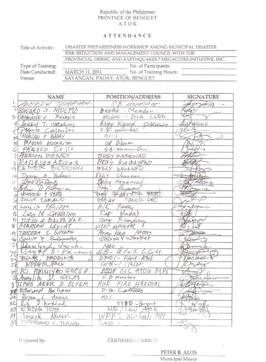
174
175
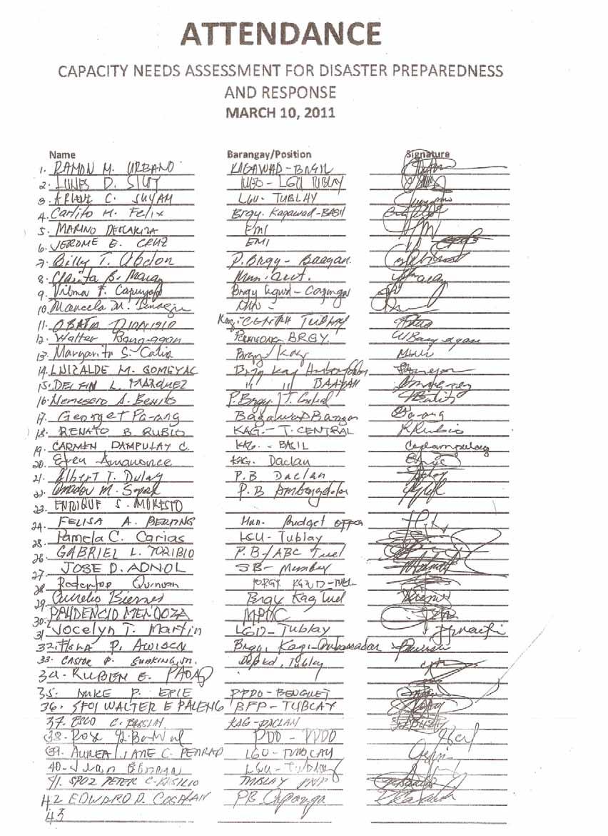
176
177
178
179
180
181
182
183
184
185
186
187
188
189
190
191
192
193
194
195
196
197
198
199
200
201
202
203 VI. Local DRM Related Documents Province of Benguet No. LGU Council Office Plans Budget 1 Benguet (Province) Executive Order No : Constituting the Benguet Provincial Disaster Risk Reduction and Management Council (PDRRMC) The PDRRM Office has not yet been established. The Provincial Planning and Development Officer has been assigned as Action Officer by the Governor Provincial Development Physical Framework Plan (PDPFP) currently being reviewed and revised 5% Local DRRM Fund: P29,106, Tublay (Municipality) Executive Order No : Creation of the Municipal Disaster Risk Reduction Management Council (MDRRMC) Municipal Ordinance No : Ordinance Creating the Position of Municipal Risk Reduction and Management Officer (MDRRMO) Salary Grade 11, Under the Office of the Municipal Mayor of Tublay, Benguet Tublay Contingency Plan being formulated: Land Use Plan being updated; Municipal Disaster Risk Reduction Management and Preparedness Action Plan in Place P13,751,000 as indicated in Municipal Disaster Risk Reduction Management and Preparedness Action Plan EMI P age
204 Atok (Municipality) Administrative Order No. 5 Series of 2010: An Administrative Order Creating the Municipal Disaster Risk Reduction and Management Council and the Local Disaster Risk Reduction Management Office Administrative Order No. 5 Series of 2010: An Administrative Order Creating the Municipal Disaster Risk Reduction and Management Council and the Local Disaster Risk Reduction Management Office Emergency Operations Plan (updating in progress); CLUP being updated 5% CF: Php 2,491,155 EMI P age
205 Province of Laguna No. LGU Council Office Plan Budget 1 Laguna (Province) An EO creating the Provincial Disaster Risk Reduction and Management Council. Composition of the council is based from Section 2, Rule 5 of IRR of RA There is no permanent physical building of PDRRMO. The creation of the PDRRMO office is not yet established. Provincial Development Physical Framework Plan, Provincial Disaster Risk Reduction and Management Plan. P49, 363,070 2 Pila (Municipality) There is an Executive Order establishing the Municipal Disaster Risk Management Council. Municipal Disaster Action Center is in place with 3 personnel. SOPs in place Comprehensive Land Use Plan and Zoning Ordinance, Comprehensive Development Plan P1,884, Mabitac (Municipality) MDRRMC is established At the moment, there is a plan on creating DRRMO and center CLUP/ZO, CDP P1,239, EMI P age
206 Province of Cagayan No. LGU Council Office Plan Budget 1 Cagayan (Province) 2 Enrile (Municipality) Ordinance on the establishment of the Provincial Climate Change and DRRM Council for final approval by the SP. Executive Order # 2 (series of 2011): Reorganization of Municipal Disaster Risk Reduction and Management Council from the old MDCC. The executive order lacks provisions on a laiason office let alone a prelude to the DRRMO. Pending adoption of the ordinance DRM creation of PDRRMO; Organizational structure includes: 1) Climate Change and DRR & Management Officer, 2) Administrative Officer V, Planning Office III and Special Operations Officer III Awareness in the passage of LDRRMO is not articulated in the municipal level. Not informed in terms of crafting the municipal ordinance. The Municipal ordinance is not yet in place. There is no LDRMMO/LDRRMC Lack of an updated contingency plan based on international standards (IAEMS); Ordinance stipulates for the adoption and implemention of a coherent, comprehensive, integrated, efficient and responsive DRM program incorporated in the development plan in the province as well as the other local government units Existing Emergency/Contingency Plan is not updated For the PDRRM Office, the budget is P4 million for Personnel and P1 million for Maintenance and Operational Expenses but under the law, P56, is allotted for DRM activities P716,383 EMI P age
207 3 Amulung (Municipality) No Municipal Ordinance on DRM; (LDRRMO/C) is not articulated among municipal officials. Same with the Municipality of Enrile, there is an existing Executive Order (EO # 35 Series of 2011) contain provisions for the reorganization of the DRRMC. The EO stipulates the formulation of a disaster plan and a provision on the established MDRRMO that is under the office of the Mayor. Although the EO # 35 stipultes the formulation of the disaster plan, there is no comprehensive disaster management plan in place P1,323,713 EMI P age
208 Province of Sorsogon No. LGU Council Office Plan Budget 1 Sorsogon (Province) Executive Order # 006 A Series of 2010 Organization of the PDRRMC Resolution No Approving the Renaming of Sorsogon Provincial Public Safety Disaster Risk Management Office(SPPSDMO) to Sorsogon Provincial Disaster Risk Management Office (SPDRMO) Provincial Ordinance No Creation of the Sorsogon Provincial Public Safety and Disaster Management Office Sorsogon Provincial Disaster Protocol/Contingency Plan in place; Currently updating their PDPFP ( ); Oxfam Manual of Operations PDRRMO; Sorsogon Health Emergency Preparedness, Response and Recovery Plan The Maintenance and Other Operating Expenses (MOOE) amounting to P488,000 as reflected in the 2009 Provincial Public Safety and Management Office Annual Report. Other related expenses were sourced out from established INGO partners such as Oxfam GB/GVDP/ World Vision, Christian Aid 2 Juban (Municipality) Executive Order # creating JMDRRMC There is a pending council resolution (SB), Resolution no. 1 Series of 2011 for the creation of the MDRRM office Juban Disaster Management Plan 2006; CDP; Currently developing their Risk Sensitive Land Use Plan CF: P2,500,000 EMI P age
209 No. LGU Council Office Plan Budget 3 Irosin (Municipality) Executive Order No. 10 Organizing the Municipal Disaster Risk Management Council (MDRRMC)of the Municipality of Irosin, Sorsogon MDRRM Office still being created with proposed 4 permanent staff. Temporary office building is available, budget issue PS ceiling cap. Bulusan Contingency Plan; Irosin Contingency Plan 2010; CDP; DRRM Plan 2011; Reentry Plan 2011 DRRM fund: P3,663,165 EMI P age
210
211
212
213
214
215
216
217
218
219
220
221
222
223
224
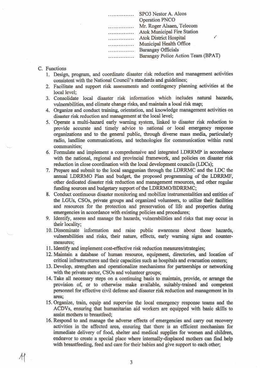
225
226
227
228
229
230
231
232
233
234
235
236
237
238
239
240
241 EXECUTIVE ORDER No. 006-A Series of 2010 ORGANIZATION OF THE PROVINCIAL DISASTER RISK REDUCTION AND MANAGEMENT COUNCIL WHEREAS, Republic Act No or the Philippine Disaster Risk Reduction and Management Act of 2010 (DRRM Act), an Act Strengthening the Philippine Disaster Lusk Reduction and Management System, Providing for the National Disaster Risk Reduction and Management Framework and Institutionalizing the National Disaster Risk Reduction and Management Plan, Appropriating Funds Therefore and For Other Purposes which was promulgated and approved on May 27, 2010, aims to transform and modernize the Philippine disaster management system, institutionalize the best practices of local communities which have been implementing effective DRRM and shifts its focus from emergency relief and response (post-disaster) to disaster prevention and risk reduction (pre-disaster); WHEREAS, pursuant to Section 11 of the abovementioned law, The existing Provincial, City, and Municipal Disaster Coordinating Councils shall henceforth be known as the Provincial, City, and Municipal Disaster Risk Reduction and Management Councils. The Barangay Disaster Coordinating Councils shall cease to exist and its powers and functions shall henceforth be assumed by the existing Barangay Development Councils (BDCs) which shall serve as the LDRRMCs in every barangay. ; WHEREAS, there is a need to organize the Provincial Disaster Risk Reduction and Management Council, which shall oversee the implementation of the Provincial Disaster Risk Reduction and Management Plan formulated by the Provincial Disaster Risk Management Office. NOW, THEREFORE, I, RAUL R. LEE, Provincial Governor of Sorsogon, by virtue of the power vested in me by law, do hereby direct/order the following: Section 1. ORGANIZATION AND COMPOSITION. There is hereby created the Provincial Disaster Risk Reduction and Management, which shall be composed of but not limited to the following: Chairman Members : Provincial Governor : SPDRMO PPDO PSWDO PHO OPA GAD Office PEO PVO PBO PENRO-LGU Sangguniang Panlalawigan The Division Head/Superintendent of Schools of the DepED The highest-ranking officer of the Armed Forces of the Philippines (AFP) assigned in the province The Provincial Director of the Philippine National Police (PNP) The Provincial Director/Fire Marshall of the Bureau of Fire Protection (BFP) Philippine Coast Guard 1
242 Department of Environment & Natural Resources Department of Interior Local Government The Provincial Federation President League Barangay The Philippine National Red Cross (PNRC) Four (4) accredited CSOs and One (1) private sector representative. Support Members: Philippine Information Agency (PIA) PHIVOLCS PAGASA Department of Health (DOH) Department of Trade & Industry (DTI) National Food Authority (NFA) Department of Public Works & Highways (DPWH) I&II National Irrigation Authority (NIA) SORECO I & II Sorsogon Water District Energy Development Corporation Section 2. FUNCTIONS, DUTIES AND RESPOSIBILITES. The PDRRMC shall have the following functions: 1. Approve, monitor and evaluate the implementation of the Provincial Disaster Risk Reduction and Management Plan and regularly review and test the plan consistent with other national and local planning programs; 2. Ensure the integration of disaster risk reduction and climate change adaptation into local development plans, programs and budgets as a strategy in sustainable development and poverty reduction; 3. Recommend the implementation of forced or preemptive evacuation of local residents, if necessary; and 4. Convene the Council once every three (3) months or as necessary. Section 3. ALTERNATIVE REPRESENTATION TO THE COUNCIL. Each regular member shall designate and submit name of a permanent alternate representative to the Council through the Secretariat. The officially designated alternate representative shall be recognized as the only official representative of each council member. Should both be unavailable, participation of another representative must be covered by proper authorization issued and signed by the head of the agency/organization. As a general rule, a single individual can not represent more than one (1) agency/organization. The officially designated alternate representative shall compose the PDRRMC Technical Working Group (TWG). Section 4. TECHNICAL WORKING GROUP. A Technical Working Group (TWG) composed of representatives from member agencies/organization is hereby created to provide technical assistance to the Council. The TWG shall be headed by the SPDRMO. Section 5. FUNCTIONS OF THE TECHNICAL WORKING GROUP. The Technical Working Group shall perform the following duties and functions: a. Assist in the formulation of the Provincial Disaster Risk Reduction and Management Plan; 2
243 b. Act as advisory/recommendatory to the Council on matter concerning the affairs and operations of the PDRRMC; c. Provide technical assistance and serve as advisory to the Council in the management of the PDRRMC particularly in the performance of its functions as provided for in Section 11(b) of the Act; d. Prepare plans and programs related to Disaster Risk Reduction and Management for review and approval of the Council and assist in their implementation; e. Serve as the technical arm of the Council in the conduct of IEC; f. Provide technical assistance to the Council in sourcing out funds from funding institutions/organizations; g. Assist in the enforcement of DRRM law and regulations; and h. Assist in the monitoring and evaluation of plans and programs implemented by the Council. Section 6. COUNCIL SECRETARIAT. Pursuant to Section 12(c)(18) of the Act, the Sorsogon Provincial Disaster Risk Management Office (SPDRMO) shall officially serve as the Secretariat and Executive arm to the Provincial Disaster Risk Reduction and Management Council. Section 7. FUNCTION OF THE SECRETARIAT. In addition to the functions enumerated in Section 12(c) of the Act, SPDRMO as Council Secretariat shall perform the following duties and functions: a. Prepare the minutes and agenda, records the attendance and proceedings of all meetings of the Council; b. Serve notices to all members of the Council; c. Furnishes the members of the Council certified copies of the minutes of the meetings; d. Keeps a register of the names and addresses of all members and keeps complete file of the resolutions and executive orders relevant to the reorganization of the Council and the affairs and deliberations of the Council; e. In general, performs all duties incidental to the office of the secretariat and those that may be assigned by the Chairman of/or the Council. Section 8. NOTICE OF MEETINGS. A notice, containing the date, place, time and agenda shall be served either by mail, personal delivery, electronic mail ( ), short messaging system (SMS/text messaging) or through facsimile transmittal or any means approved by the Council, to every member at least seven (7) days before the date of regular meeting and at least two (2) days before the special meeting as the case maybe. Section 9. QUORUM. All Council meetings shall require two-thirds (2/3) of all members to constitute a quorum. Section 10. TOPIC FOR DELIBERATION. Before the start of any Council meeting, any member may recommend to the Chairman, subject to his approval, items to be included in the agenda. Section 11. VOTING. The Council shall endeavor to reach a consensus on all issues. Where it is not possible, the issue shall be resolved through a democratic 3
244 process which is through the casting of votes of all duly authorized representatives present. Each agency/organization will only have one (1) vote. A majority vote of all duly authorized representatives present shall be enough to give a motion/issue due course. Section 12. COVERAGE. This Order shall be enforced in the province of Sorsogon. Section 13. FUNDING. Expenses to be incurred in the implementation of this Order shall be charged against the local funds. Section 14. REPEALING CLAUSE. All Orders, rules and regulations and other issuances or parts thereof, which are inconsistent with this Order, are hereby repealed or modified accordingly. Section 15. EFFECTIVITY. This Order shall take effect immediately. SO ORDERED this 12 th day of October 2010, at Sorsogon Province. RAUL R. LEE Governor 4
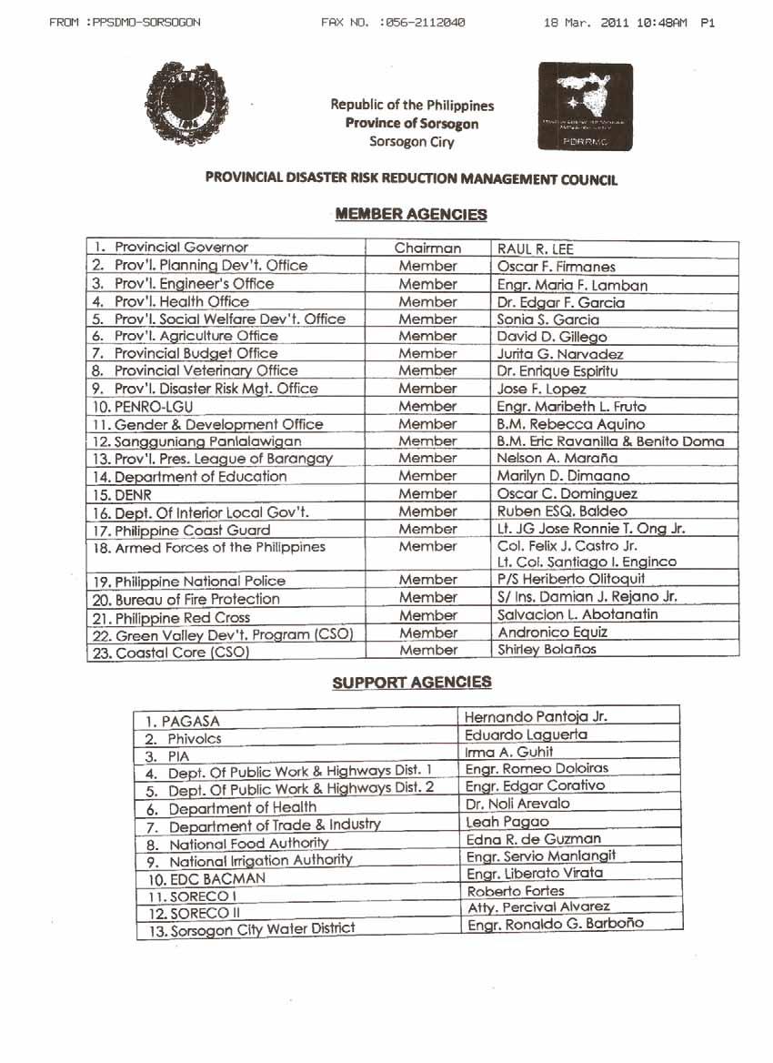
245
246
247
248
249
250
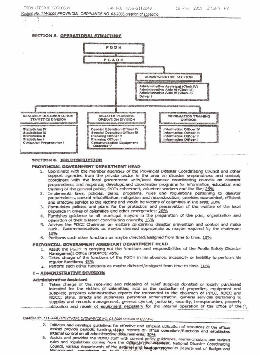
251
252
253
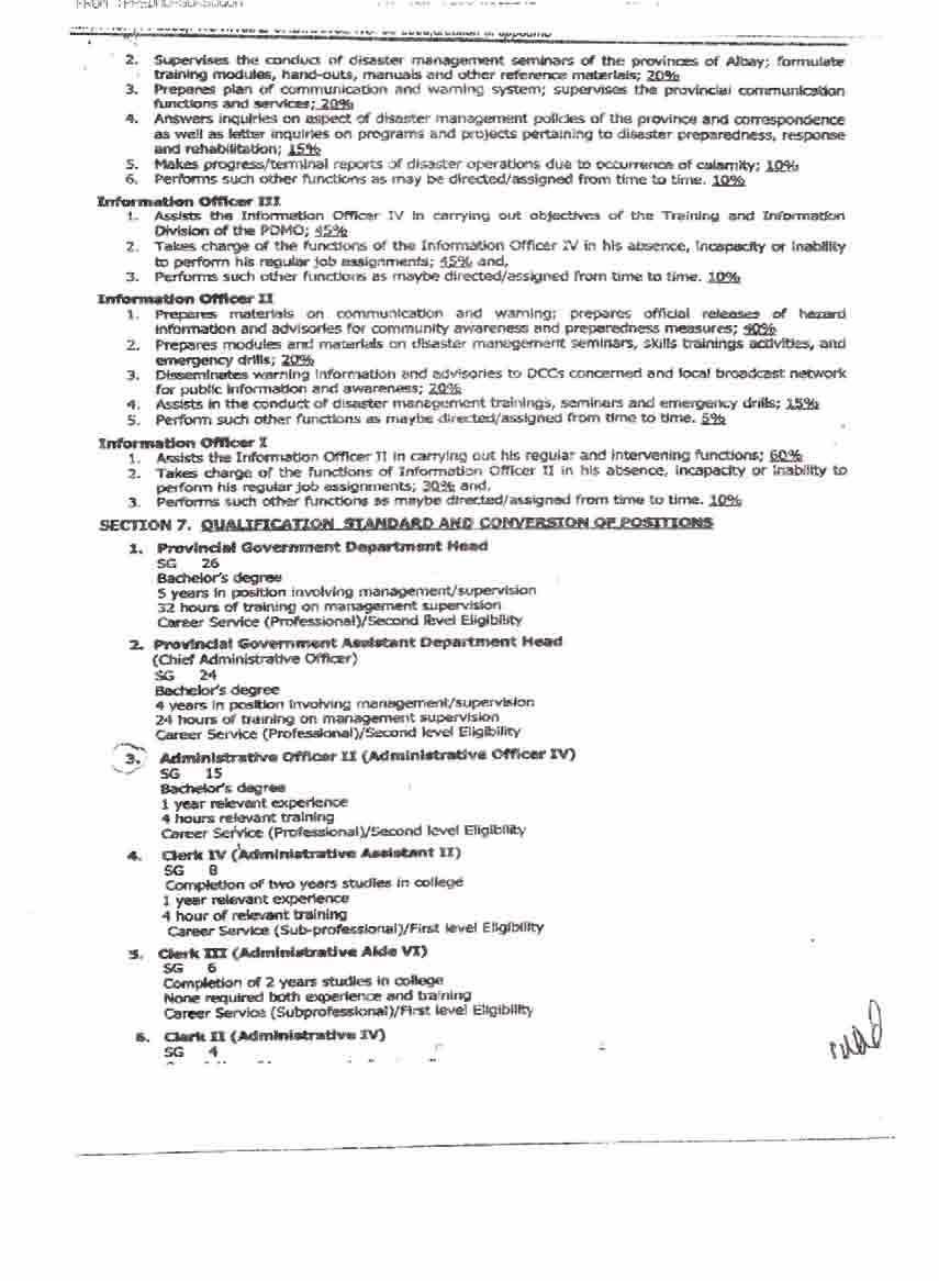
254
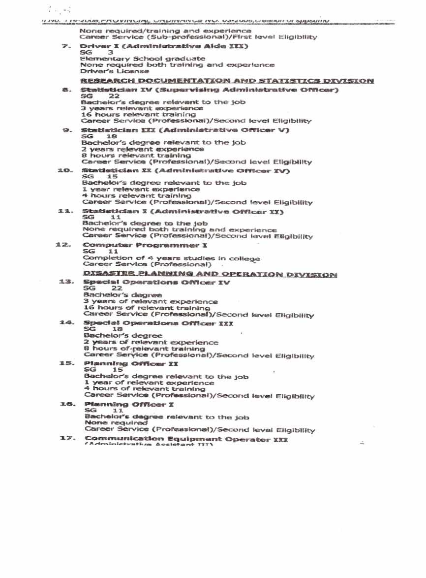
255
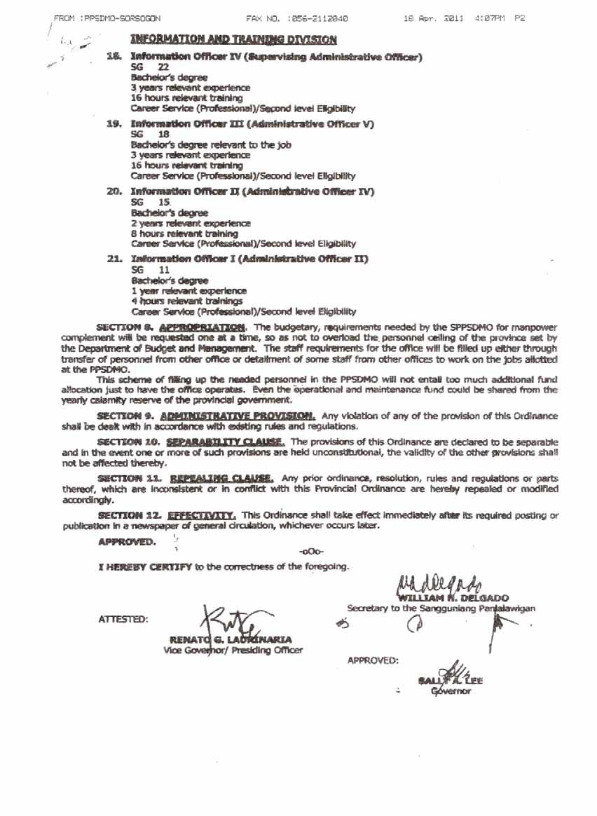
256
July Philippine Disaster Response Structure and its linkage to WFP Programmes
 July 2015 Philippine Disaster Response Structure and its linkage to WFP Programmes NDRRMC Functional Structure President OVERSIGHT Secretary, Department of National Defense CHAIRPERSON, NDRRMC Administrator,
Scope of Presentation
 Scope of Presentation Philippines DRRM Act of 2010 The TY Yolanda (Haiyan) and other DRRM Experiences CBDRRM Policy Implementation Challenges and Way Forward The Philippine Archipelago occupies the western
MAKATI: investing in disaster risk reduction towards a resilient city
 MAKATI: investing in disaster risk reduction towards a resilient city ATTY. VIOLETA SOMERA SEVA SENIOR ADVISER, OFFICE OF THE MAYOR MAKATI CITY, PHILIPPINES Outline of the Presentation Introduction to
North Lombok District, Indonesia
 North Lombok District, Indonesia Local progress report on the implementation of the 10 Essentials for Making Cities Resilient (2013-2014) Mayor: H. Djohan Sjamsu, SH Name of focal point: Mustakim Mustakim
Improving Patient Safety: First Steps
 The African Partnerships for Patient Safety Framework Improving Patient Safety: First Steps This resource outlines an approach to improving patient safety using a partnership model, structured around 12
WHO s response, and role as the health cluster lead, in meeting the growing demands of health in humanitarian emergencies
 SIXTY-FIFTH WORLD HEALTH ASSEMBLY A65/25 Provisional agenda item 13.15 16 March 2012 WHO s response, and role as the health cluster lead, in meeting the growing demands of health in humanitarian emergencies
Ahmedabad Action Agenda for School Safety
 Ahmedabad Action Agenda for School Safety SA~E, SCHOOLS Outcome document of the International Conference on School Safety 18th - 20th January, 2007 Ahmedabad, India PREAMBLE The International Conference
DISASTER RISK REDUCTION OF MEGACITIES AND COMPLEX URBAN METROPOLISES PREPARATORY ASSISTANCE PHASE
 www.emi-megacities.org DISASTER RISK REDUCTION OF MEGACITIES AND COMPLEX URBAN METROPOLISES PREPARATORY ASSISTANCE PHASE Summary of Activities and Accomplishments Final Report Submitted to UNDP/BCPR 30
Emergency Education Cluster Terms of Reference FINAL 2010
 Emergency Education Cluster Terms of Reference FINAL 2010 Introduction The Government of Pakistan (GoP), in partnership with the Humanitarian Coordinator in Pakistan, is responsible for leading and ensuring
Informal note on the draft outline of the report of WHO on progress achieved in realizing the commitments made in the UN Political Declaration on NCDs
 Informal note on the draft outline of the report of WHO on progress achieved in realizing the commitments made in the UN Political Declaration on NCDs (NOT AN OFFICIAL DOCUMENT OR FORMAL RECORD 1 ) Geneva,
WFP Philippines Country Office. Actions to be taken
 Decentralized evaluation for evidence-based decision making Office of Evaluation Decentralized Evaluation Quality Assurance System (DEQAS) Response Evaluation of Disaster Preparedness and Response/Climate
COMMISSION DE LA CEDEAO PLAN OF ACTION OF THE ECOWAS HUMANITARIAN POLICY ( )
") COMISSÃO DA CEDEAO COMMISSION COMMISSION DE LA CEDEAO PLAN OF ACTION OF THE HUMANITARIAN POLICY (2012 2017) 1 PLAN OF ACTION OF THE HUMANITARIAN POLICY STRATEGIC OBJECTIVE 1 Ensuring Appropriate Legal
COMISSÃO DA CEDEAO COMMISSION COMMISSION DE LA CEDEAO PLAN OF ACTION OF THE HUMANITARIAN POLICY (2012 2017) 1 PLAN OF ACTION OF THE HUMANITARIAN POLICY STRATEGIC OBJECTIVE 1 Ensuring Appropriate Legal
Key Concerns & Trends
 Typhoon Hagupit (Ruby), Dec. 5, 2014 BLUF Implications to PACOM Dept. of Foreign Affairs of the Government of the Philippines (GOP) has formally requested assistance from the U.S. (RP DFA RFA). However,
DEMOCRATIC PEOPLE S REPUBLIC OF KOREA
 DEMOCRATIC PEOPLE S REPUBLIC OF KOREA Assessment of Capacities using SEA Region Benchmarks for Emergency Preparedness and Response SEA-EHA-22-DEMOCRATIC PEOPLE S REPUBLIC OF KOREA Assessment of Capacities
PROJECT COMPLETION REPORT
 PROJECT COMPLETION REPORT This report must be completed and signed by the Contact person. The information provided below must correspond to the financial information that appears in the financial report.
TERMS OF REFERENCE Individual Contractor. National Consultant Post Disaster Needs Assessment in Cambodia
 TERMS OF REFERENCE Individual Contractor 1. Project Information Assignment Title Organization Post Level Cluster/Project Duty Station Duration National Consultant Post Disaster Needs Assessment in Cambodia
History of Disaster Management in the Philippines
 Page 1 History of Disaster Management in the Philippines Commonwealth to Post-Commonwealth Era During the Commonwealth days, two (2) executive orders were issued by the late President Manuel L. Quezon,
WHO s response, and role as the health cluster lead, in meeting the growing demands of health in humanitarian emergencies
 130th session EB130.R14 Agenda item 6.15 21 January 2012 WHO s response, and role as the health cluster lead, in meeting the growing demands of health in humanitarian emergencies The Executive Board, Having
TERMS OF REFERENCE. East Jerusalem with travel to Gaza and West Bank. June 2012 (flexible depending on consultant availability between June-July 2012)
") TERMS OF REFERENCE THE DEVELOPMENT OF TRAINING FOR WASH CLUSTER PARTNERS IN THE DEVELOPMENT & DESIGN OF KNOWLEDGE, ATTITUDE, PRACTICE SURVEYS IN THE OCCUPIED PALESTINIAN TERRITORY. Summary Title Purpose
TERMS OF REFERENCE THE DEVELOPMENT OF TRAINING FOR WASH CLUSTER PARTNERS IN THE DEVELOPMENT & DESIGN OF KNOWLEDGE, ATTITUDE, PRACTICE SURVEYS IN THE OCCUPIED PALESTINIAN TERRITORY. Summary Title Purpose
Spread Pack Prototype Version 1
 African Partnerships for Patient Safety Spread Pack Prototype Version 1 November 2011 Improvement Series The APPS Spread Pack is designed to assist partnership hospitals to stimulate patient safety improvements
Direct NGO Access to CERF Discussion Paper 11 May 2017
 Direct NGO Access to CERF Discussion Paper 11 May 2017 Introduction Established in 2006 in the United Nations General Assembly as a fund for all, by all, the Central Emergency Response Fund (CERF) is the
Incorporated Research Institutions for Seismology. Request for Proposal. IRIS Data Management System Data Product Development.
 Incorporated Research Institutions for Seismology Request for Proposal IRIS Data Management System Data Product Development February 8, 2011 RFP IRIS Data Management System Data Product Development Table
Practical Data Use for Disaster Prevention 3rd JPTM
 Practical Data Use for Disaster Prevention 3rd JPTM 13-15 March 2007, Singapore Edna I. Conda Civil Defense Officer Office of Civil Defense National Disaster Coordinating Council REPUBLIC OF THE PHILIPPINES
Monthly Progress Report. Tahafuz: Building Resilience through Community Based Disaster Risk Management in the Sindh Province of Pakistan
 IDENTIFICATION: Name of Project Monthly Progress Report Tahafuz: Building Resilience through Community Based Disaster Risk Management in the Sindh Province of Pakistan Name of the Organization Rural Support
TERMS OF REFERENCE RWANDA LESSONS LEARNED ON DISASTER RECOVERY
 TERMS OF REFERENCE RWANDA LESSONS LEARNED ON DISASTER RECOVERY Job Title: Category: Duty Station: Type of contract: Expected starting date: Duration of assignment: Individual Consultancy Communications
Regional consultation on the availability and safety of blood transfusion during humanitarian emergencies
 Summary report on the Regional consultation on the availability and safety of blood transfusion during humanitarian emergencies WHO-EM/LAB/387/E Tunis, Tunisia 15 16 May 2016 Summary report on the Regional
Guidelines for Preventive and Social Medicine/Community Medicine/Community Health Curriculum in the Undergraduate Medical Education
 SEA-HSD-325 Distribution: General Guidelines for Preventive and Social Medicine/Community Medicine/Community Health Curriculum in the Undergraduate Medical Education World Health Organization 2010 All
Kampala, Uganda. Local progress report on the implementation of the Hyogo Framework for Action ( )
") Kampala, Uganda Local progress report on the implementation of the Hyogo Framework for Action (2013-2014) Name of focal point: Emmanuel Serunjoji Organization: Kampala Capital City Authority Title/Position:
Kampala, Uganda Local progress report on the implementation of the Hyogo Framework for Action (2013-2014) Name of focal point: Emmanuel Serunjoji Organization: Kampala Capital City Authority Title/Position:
The preparation and integration of Turkey s National Disaster Response Plan
 Disaster Management and Human Health Risk IV 1 The preparation and integration of Turkey s National Disaster Response Plan F. Oktay Republic of Turkey Prime Ministry Disaster and Emergency Management Authority,
Tanjung Pinang, Indonesia
 Tanjung Pinang, Indonesia Local progress report on the implementation of the 10 Essentials for Making Cities Resilient (2013-2014) Name of focal point: Yusniar Nurdin Organization: BNPB Title/Position:
GAO WARFIGHTER SUPPORT. DOD Needs to Improve Its Planning for Using Contractors to Support Future Military Operations
 GAO United States Government Accountability Office Report to Congressional Committees March 2010 WARFIGHTER SUPPORT DOD Needs to Improve Its Planning for Using Contractors to Support Future Military Operations
Chapter 17 Disaster Risk Reduction and Management and Land Use Planning
 Chapter 17 Disaster Risk Reduction and Management and Land Use Planning 17.1 Introduction: Disaster Risk Reduction and Management and Land Use Planning Land use planning is an effective tool for disaster
PROMISE PROJECT. Philippines NARRATIVE PROGRESS REPORT. Implemented By: Center for Disaster Preparedness. Submitted To: ADPC
 PROMISE PROJECT Philippines NARRATIVE PROGRESS REPORT Implemented By: Center for Disaster Preparedness Submitted To: ADPC Reporting Period: August 2008 Activity Summary Objectives and the corresponding
Water, Sanitation and Hygiene Cluster. Afghanistan
 Water, Sanitation and Hygiene Cluster Afghanistan Strategy Paper 2011 Kabul - December 2010 Afghanistan WASH Cluster 1 OVERARCHING STRATEGY The WASH cluster agencies in Afghanistan recognize the chronic
FIRE AND DISASTER MANAGEMENT ORGANIZATION ACT
 FIRE AND DISASTER MANAGEMENT ORGANIZATION ACT (LAW NO. 226, DEC. 23, 1947) Amendments (1) Law No. 187, Jul.24, 1948 (25) Law No.83, Dec.10, 1983 (2) Law No.193, Jun.4, 1949 (26) Law No.69, Jun.21, 1985
COMMISSION IMPLEMENTING DECISION. of
 EUROPEAN COMMISSION Brussels, 16.10.2014 C(2014) 7489 final COMMISSION IMPLEMENTING DECISION of 16.10.2014 laying down rules for the implementation of Decision No 1313/2013/EU of the European Parliament
Pan-American Disaster Response Unit
 Pan-American Disaster Response Unit (Appeal 01.25/2001) Click on figures to go to budget In CHF In CHF 1. Disaster Preparedness 1,672,000 Total 1,672,000 Pan-American Disaster Response Unit (PADRU) Background
Delay in response may result in increased loss of lives and livelihoods.
 Islamic Republic of Afghanistan National Disaster Management Authority (ANDMA) 26-29 August 2013 1 Delay in response may result in increased loss of lives and livelihoods. 2 Introduction Afghanistan has
Response Protocols July 26,
 Response Protocols July 26, 2011 1 Scope These protocols are applicable within the geographical boundaries of Santa Clara County and the sixteen jurisdictions within Santa Clara County. The protocols apply
Experiential Education
 Experiential Education Experiential Education Page 1 Experiential Education Contents Introduction to Experiential Education... 3 Experiential Education Calendar... 4 Selected ACPE Standards 2007... 5 Standard
Toolbox for the collection and use of OSH data
 20% 20% 20% 20% 20% 45% 71% 57% 24% 37% 42% 23% 16% 11% 8% 50% 62% 54% 67% 73% 25% 100% 0% 13% 31% 45% 77% 50% 70% 30% 42% 23% 16% 11% 8% Toolbox for the collection and use of OSH data 70% These documents
Terms of Reference. Consultancy for Third Party Monitor for the Aga Khan Development Network Health Action Plan for Afghanistan (HAPA)
") Terms of Reference Consultancy for Third Party Monitor for the Aga Khan Development Network Health Action Plan for Afghanistan (HAPA) I. Purpose and Objectives of the Assignment Aga Khan Foundation Canada
Terms of Reference Consultancy for Third Party Monitor for the Aga Khan Development Network Health Action Plan for Afghanistan (HAPA) I. Purpose and Objectives of the Assignment Aga Khan Foundation Canada
European Forum for Disaster Risk Reduction 1 (EFDRR) Concept Paper. Overview
 Concept Paper. Overview") European Forum for Disaster Risk Reduction 1 (EFDRR) Concept Paper Overview Overall Objective: 1. The European Forum for Disaster Risk Reduction is intended to serve as a forum to stimulate and facilitate
European Forum for Disaster Risk Reduction 1 (EFDRR) Concept Paper Overview Overall Objective: 1. The European Forum for Disaster Risk Reduction is intended to serve as a forum to stimulate and facilitate
Kampala, Uganda. Local progress report on the implementation of the 10 Essentials for Making Cities Resilient ( )
") Kampala, Uganda Local progress report on the implementation of the 10 Essentials for Making Cities Resilient (2013-2014) Name of focal point: Emmanuel Serunjoji Organization: Kampala Capital City Authority
Kampala, Uganda Local progress report on the implementation of the 10 Essentials for Making Cities Resilient (2013-2014) Name of focal point: Emmanuel Serunjoji Organization: Kampala Capital City Authority
Memorandum of Understanding
 Memorandum of Understanding between The Greater Rochester Chapter of the American Red Cross and the Monroe County (NY) Amateur Radio Emergency Service (ARES) I. Purpose The purpose of this Memorandum of
Disaster Management Structures in the Caribbean Mônica Zaccarelli Davoli 3
 Disaster Management Structures in the Caribbean Mônica Zaccarelli Davoli 3 Introduction This chapter provides a brief overview of the structures and mechanisms in place for disaster management, risk reduction
Miami-Dade County, Florida Emergency Operations Center (EOC) Continuity of Operations Plan (COOP) Template
 Continuity of Operations Plan (COOP) Template") Miami-Dade County, Florida Emergency Operations Center (EOC) Continuity of Operations Plan (COOP) Template Miami-Dade County Department of Emergency Management 9300 NW 41 st Street Miami, FL 33178-2414
Miami-Dade County, Florida Emergency Operations Center (EOC) Continuity of Operations Plan (COOP) Template Miami-Dade County Department of Emergency Management 9300 NW 41 st Street Miami, FL 33178-2414
DOH Policy on Healthcare Emergency & Disaster Management for the Emirate of Abu Dhabi
 DOH Policy on Healthcare Emergency & Disaster Management for the Emirate of Abu Dhabi Department of Health, October 2017 Page 1 of 22 Document Title: Document Number: Ref. Publication Date: 24 October
Evaluation of the Global Humanitarian Partnership between Save the Children, C&A and C&A Foundation
 Evaluation of the Global Humanitarian Partnership between Save the Children, C&A and C&A Foundation Terms of Reference Contents: I. INTRODUCTION 2 II. GLOBAL HUMANITARIAN PARTNERSHIP 3 III. SCOPE 4 IV.
Chapter 3: Business Continuity Management
 Chapter 3: Business Continuity Management GAO Why we did this audit: Nova Scotians rely on critical government programs and services Plans needed so critical services can continue Effective management
Draft 2016 Emergency Management Standard Release for Public Comment March 2015
 Draft 2016 Emergency Management Standard Release for Public Comment March 2015 Emergency Management Accreditation Program Publication Note The Emergency Management Standard by the Emergency Management
Background and Introduction
 Global Education and Training Institute (GETI) with additional funding support from 2017 KOICA-UNISDR Joint Fellowship Program Mainstreaming Disaster Risk Reduction and Climate Change Adaptation for Sustainable
BY ORDER OF THE AIR FORCE POLICY DIRECTIVE SECRETARY OF THE AIR FORCE 20 JULY 1994
 BY ORDER OF THE AIR FORCE POLICY DIRECTIVE 32-70 SECRETARY OF THE AIR FORCE 20 JULY 1994 Civil Engineering ENVIRONMENTAL QUALITY 1.1. Achieving and maintaining environmental quality is an essential part
WORLD HEALTH ORGANIZATION
 WORLD HEALTH ORGANIZATION EXECUTIVE BOARD EB115/6 115th Session 25 November 2004 Provisional agenda item 4.3 Responding to health aspects of crises Report by the Secretariat 1. Health aspects of crises
INDONESIA. Assessment of Capacities using SEA Region Benchmarks for Emergency Preparedness and Response
 INDONESIA Assessment of Capacities using SEA Region Benchmarks for Emergency Preparedness and Response SEA-EHA-22-INDONESIA Assessment of Capacities using SEA Region Benchmarks for Emergency Preparedness
Health System Outcomes and Measurement Framework
 Health System Outcomes and Measurement Framework December 2013 (Amended August 2014) Table of Contents Introduction... 2 Purpose of the Framework... 2 Overview of the Framework... 3 Logic Model Approach...
UNESCO Chair in Technologies for Development
 COOPERATION & DEVELOPMENT CENTER - CODEV Agoes Antara / Pixoto Ecole Polytechnique Fédérale de Lausanne - EPFL UNESCO Chair in Technologies for Development 2016 International Conference from innovation
Gianyar District, Indonesia
 Gianyar District, Indonesia Local progress report on the implementation of the Hyogo Framework for Action (2013-2014) Mayor: A.A. Gde Agung Bharata Name of focal point: Valentinus Irawan Organization:
Comprehensive Emergency Management Plan
 Comprehensive Emergency Management Plan Horry County Emergency Management Blank Intentionally -ii- CEMP Introduction EXECUTIVE SUMMARY This Comprehensive Emergency Management Plan was written by the
Outline of the Presentation
 PHILIPPINE DEPARTMENT OF TOURISM Outline of the Presentation Review of the Limitations of Domestic Tourism Statistics Compilation Milestones in the Development of Tourism Statistics Compilation in the
PROGRAM FOR ENHANCEMENT OF EMERGENCY RESPONSE (PEER)
") ASIAN DISASTER PREPAREDNESS CENTER US AID Project PROGRAM DESCRIPTION PROGRAM FOR ENHANCEMENT OF EMERGENCY RESPONSE (PEER) 1. BACKGROUND Past experience shows that well developed Search and Rescue (SAR)
ASIAN DISASTER PREPAREDNESS CENTER US AID Project PROGRAM DESCRIPTION PROGRAM FOR ENHANCEMENT OF EMERGENCY RESPONSE (PEER) 1. BACKGROUND Past experience shows that well developed Search and Rescue (SAR)
Dumai, Indonesia. Local progress report on the implementation of the 10 Essentials for Making Cities Resilient ( )
") Dumai, Indonesia Local progress report on the implementation of the 10 Essentials for Making Cities Resilient (2013-2014) Name of focal point: Yusniar Nurdin Organization: BNPB Title/Position: Technical
Dumai, Indonesia Local progress report on the implementation of the 10 Essentials for Making Cities Resilient (2013-2014) Name of focal point: Yusniar Nurdin Organization: BNPB Title/Position: Technical
2.13. Training for Emergency Health Management
 WHO/EHA EMERGENCY HEALTH TRAINING PROGRAMME FOR AFRICA 2. TOOLS 2.13. Training for Emergency Health Management Panafrican Emergency Training Centre, Addis Ababa, July 1998 2.13. Training for Emergency
Terms of Reference Approved 30 April 2015/ Revised 29 September 2016
 COORDINATION DESK Terms of Reference Approved 30 April 2015/ Revised 29 September 2016 1. Introduction This document 1 describes the roles and working procedures for the Actors involved in the 10YFP Sustainable
Emergency Support Function 14. Community Recovery and Mitigation
 Emergency Support Function 14 Community Recovery and Mitigation ESF COORDINATOR: PRIMARY AGENCY: SUPPORT AGENCIES: County Emergency Management Agency County Administrative Officer Chief Elected Officials
A/58/320. General Assembly. United Nations
 United Nations General Assembly Distr.: General 27 August 2003 Original: English A/58/320 Fifty-eighth session Item 41 (d) of the provisional agenda* Strengthening of the coordination of humanitarian and
Emergency Operations Plan
 Mainstreaming Disaster Risk Reduction in Megacities: A Pilot Application in Metro Manila and Kathmandu Emergency Operations Plan Kathmandu Metropolitan City, Nepal February 28, 2010 http://www.emi-megacities.org
BEAHR Programs Guide. Environmental Training for Indigenous Communities
 BEAHR Environmental Training for Indigenous Communities Revision 02/Issue October 2017 Contents ECO CANADA... 2 BEAHR TRAINING PROGRAMS... 2 THE ADVANTAGE... 3 THE DELIVERY METHOD... 3 PROGRAM COSTS...
E S F 8 : Public Health and Medical Servi c e s
 E S F 8 : Public Health and Medical Servi c e s Primary Agency Fire Agencies Pacific County Public Health & Human Services Pacific County Prosecutor s Office Pacific County Department of Community Development
Health in Disaster Risk Reduction: Research and Innovation Needs
 Health in Disaster Risk Reduction: Research and Innovation Needs GLOBAL FORUM ON RESEARCH AND INNOVATION FOR HEALTH 2015 25 AUGUST 2015 PHILIPPINE INTERNATIONAL CONVENTION CENTER, MANILA, PHILIPPINES Ronald
LAW FOR THE PROTECTION OF THE CLASSIFIED INFORMATION. Chapter one. GENERAL PROVISIONS
 LAW FOR THE PROTECTION OF THE CLASSIFIED INFORMATION Prom. SG. 45/30 Apr 2002, corr. SG. 5/17 Jan 2003, amend. SG. 31/4 Apr 2003, amend. SG. 52/18 Jun 2004, suppl. SG. 55/25 Jun 2004, suppl. SG. 89/12
Laboratory Assessment Tool
 WHO/HSE/GCR/LYO/2012.2 Laboratory Assessment Tool Annex 1: Laboratory Assessment Tool / System Questionnaire April 2012 World Health Organization 2012 All rights reserved. The designations employed and
GFDRR Country Evaluation:
 GFDRR Country Evaluation: Update and Initial Observations Prepared for: 16 th Consultative Group Meeting May 6, 2015 Presented by: Mark Wagner, ICF International (Lead Evaluator) Jessica Kyle, ICF International
National Exercise Program (NEP) Overview. August 2009
 Overview. August 2009") National Exercise Program (NEP) Overview August 2009 Creating a Unified Exercise Strategy In response to presidential and congressional requirements, the Homeland Security Council in coordination with
National Exercise Program (NEP) Overview August 2009 Creating a Unified Exercise Strategy In response to presidential and congressional requirements, the Homeland Security Council in coordination with
Upon completion of the CDLS course, participants will be able to:
 The Core Disaster Life Support (CDLS) course CDLS The National Disaster Life Support (NDLS ) courses are a series of education programs to better prepare health care professionals and emergency response
<3& =&, >()$)2&+?$'$4&#&'2 *0+#$2(0' B-$' 60+ <&3+$' C(27 "#$%&'!
$)2&+?$'$4&#&'2 *0+#$2(0' B-$' 60+ <&3+$' C(27 #$%&'!") !"#$%& '()%)*"$ +(*(,%*(-& %&. +%&%,"/"&* 0$,%&(1%*(-& ()$)2&+?$'$4&#&'2 ?
!"#$%& '()%)*"$ +(*(,%*(-& %&. +%&%,"/"&* 0$,%&(1%*(-& ()$)2&+?$'$4&#&'2 ?
Emergency Response Planning: Crisis Management for Hazardous Environments
 Emergency Response Planning: Crisis Management for Hazardous Environments Page 1 of 6 Why Attend The sheer range of potential incidents and emergencies that can disrupt or even stop production are increasing.
2018 BUSINESS ENTREPRENEURSHIP PROGRAM
 NOTICE OF FUNDING AVAILABILITY FOR 2018 BUSINESS ENTREPRENEURSHIP PROGRAM Deadline for Submitting Applications: 5:00 PM-Monday, March 26, 2018 Submit to: City of Stockton Economic Development Department
INTERNATIONAL HUMANITARIAN ASSISTANCE FUNDING APPLICATION GUIDELINES FOR NON-GOVERNMENTAL ORGANIZATIONS
 INTERNATIONAL HUMANITARIAN ASSISTANCE FUNDING APPLICATION GUIDELINES FOR NON-GOVERNMENTAL ORGANIZATIONS 2 October 2014 Table of Contents Section 1: Introduction... 1 1.1 Purpose of NGO Funding Application
Mental Health Accountability Framework
 Mental Health Accountability Framework 2002 Chief Medical Officer of Health Report Injury: Predictable and Preventable Contents 3 Executive Summary 4 I Introduction 6 1) Why is accountability necessary?
A M E R I C A N S A F E T Y & H E A LT H I N S T I T U T E
 A M E R I C A N S A F E T Y & H E A LT H I N S T I T U T E American Safety & Health Institute 1450 Westec Drive Eugene, OR 97402 USA 800-246-5101 ashinstitute.org Copyright 2008 by American Safety & Health
Department of Defense INSTRUCTION
 Department of Defense INSTRUCTION NUMBER 4715.10 April 24, 1996 SUBJECT: Environmental Education, Training and Career Development USD(A&T) References: (a) Section 328 of Public Law 103-337, "National Defense
33 C. General Conference 33rd session, Paris C/74 11 October 2005 Original: English. Item 5.20 of the agenda
 U General Conference 33rd session, Paris 2005 33 C 33 C/74 11 October 2005 Original: English Item 5.20 of the agenda PROPOSAL FOR THE ESTABLISHMENT OF THE REGIONAL CENTRE ON URBAN WATER MANAGEMENT FOR
UNICEF s response to the Cholera Outbreak in Yemen. Terms of Reference for a Real-Time Evaluation
 UNICEF s response to the Cholera Outbreak in Yemen Terms of Reference for a Real-Time Evaluation Background Two years since the escalation of violence in Yemen, a second wave of fast spreading cholera
The Sphere Project strategy for working with regional partners, country focal points and resource persons
 The Sphere Project strategy for working with regional partners, country focal points and resource persons Content 1. Background 2. Aim and objectives 3. Implementation 4. Targets 5. Risks 6. Monitoring
Yolo Operational Area Oil & Hazardous Materials Response Executive Summary
 This document outlines the planning and organizational responsibilities of the Oil and Hazardous Materials (ESF #10) coordinating agencies for the Yolo Operational Area Yolo Operational Area Oil & Hazardous
SCIENCE ADVISORY COMMITTEE TERMS OF REFERENCE
 SCIENCE ADVISORY COMMITTEE TERMS OF REFERENCE FINAL Version 30 April 2012 Updates: 15 June 2012 29 July 2013 22 Aug 2013 20 Sep 2013 Marine Planning Partnership for the North Pacific Coast SCIENCE ADVISORY
Joint Evaluation of Japan s Official Development Assistance (ODA) to the Disaster Risk Reduction and Management (DRRM) Sector in the Republic of the
 to the Disaster Risk Reduction and Management (DRRM) Sector in the Republic of the") Joint Evaluation of Japan s Official Development Assistance (ODA) to the Disaster Risk Reduction and Management (DRRM) Sector in the Republic of the Philippines March 2016 Preface This Study Report for
Joint Evaluation of Japan s Official Development Assistance (ODA) to the Disaster Risk Reduction and Management (DRRM) Sector in the Republic of the Philippines March 2016 Preface This Study Report for
Rutgers School of Nursing-Camden
 Rutgers School of Nursing-Camden Rutgers University School of Nursing-Camden Doctor of Nursing Practice (DNP) Student Capstone Handbook 2014/2015 1 1. Introduction: The DNP capstone project should demonstrate
AUDIT UNDP BOSNIA AND HERZEGOVINA GRANTS FROM THE GLOBAL FUND TO FIGHT AIDS, TUBERCULOSIS AND MALARIA. Report No Issue Date: 15 January 2014
 UNITED NATIONS DEVELOPMENT PROGRAMME AUDIT OF UNDP BOSNIA AND HERZEGOVINA GRANTS FROM THE GLOBAL FUND TO FIGHT AIDS, TUBERCULOSIS AND MALARIA Report No. 1130 Issue Date: 15 January 2014 Table of Contents
Prepublication Requirements
 Prepublication Requirements Standards Revisions for Emergency Management Final Rule in Home Care The Joint Commission has approved the following revisions for prepublication. While revised requirements
EMERGENCY SUPPORT FUNCTION 1 TRANSPORTATION
 59 Iberville Parish Office of Homeland Security And Emergency Preparedness EMERGENCY SUPPORT FUNCTION 1 TRANSPORTATION I. PURPOSE: ESF 1 provides for the acquisition, provision and coordination of transportation
IASC Subsidiary Bodies. Reference Group on Meeting Humanitarian Challenges in Urban Areas Work Plan for 2012
 INTER-AGENCY STANDING COMMITTEE WORKING GROUP IASC Subsidiary Bodies Reference Group on Meeting Humanitarian Challenges in Urban Areas Work Plan for 2012 Date circulated: 31/10/2011 I Narrative Summary
Papua New Guinea: Implementation of the Electricity Industry Policy
 Technical Assistance Report Project Number: 46012 December 2012 Papua New Guinea: Implementation of the Electricity Industry Policy The views expressed herein are those of the consultant and do not necessarily
2009 REPORT ON THE WORK OF THE GLOBAL HEALTH CLUSTER to the Emergency Relief Coordinator from the Chair of the Global Health Cluster.
 2009 REPORT ON THE WORK OF THE GLOBAL HEALTH CLUSTER to the Emergency Relief Coordinator from the Chair of the Global Health Cluster Introduction Since the beginning of the implementation of the Humanitarian
Manager - HEA & Disaster Risk Management - Pacific Timor-Leste
 Manager - HEA & Disaster Risk Management - Pacific Timor-Leste Location: [Asia & Pacific] [Solomon Islands] Town/City: Honiara Category: Humanitarian & Emergency Affairs *Position location in one of the
NEW MEXICO FINANCE AUTHORITY LOCAL GOVERNMENT PLANNING FUND PROJECT MANAGEMENT POLICIES
 NEW MEXICO FINANCE AUTHORITY LOCAL GOVERNMENT PLANNING FUND PROJECT MANAGEMENT POLICIES A. PURPOSE The purpose of the Local Government Planning Fund ( LGPF or the Fund ) is to provide capital necessary
Consultancy to Develop the Model Guidelines for Child-Centred Emergency and Disaster Risk Management in Caribbean Schools and Adaptation Guide
 1 The Caribbean Disaster Emergency Management Agency REQUEST FOR PROPOSALS RFP #: UNICEF/9070/17 Consultancy to Develop the Model Guidelines for Child-Centred Emergency and Disaster Risk Management in
Project: Lead Contractor: Contract Term: Budget Period 1 (BP1): Maximum Reimbursable Amount: Background
: Maximum Reimbursable Amount: Background") Project: Borough Coalitions Lead Contractor: Contract Term: July 1, 2017 June 30, 2022 Budget Period 1 (BP1): July 1, 2017 June 30, 2018 : $100,000 Background As a component of the citywide preparedness
Project: Borough Coalitions Lead Contractor: Contract Term: July 1, 2017 June 30, 2022 Budget Period 1 (BP1): July 1, 2017 June 30, 2018 : $100,000 Background As a component of the citywide preparedness
VERMONT S RESILIENCE PROGRESS REPORT ROADMAP. August 20, 2015 BACKGROUND WHAT IS RESILIENCE? TRACKING OUR PROGRESS.
 PROGRESS REPORT August 20, 2015 VERMONT S ROADMAP TO RESILIENCE BACKGROUND Preparing for Natural Disasters and the Effects of Climate Change in the Green Mountain State In December 2013, following an 18-month