State Disaster Management Action Plan for the State of Uttarakhand
|
|
|
- Abraham Howard
- 6 years ago
- Views:
Transcription
1 State Disaster Management Action Plan for the State of Uttarakhand Disaster Mitigation & Management Centre Uttarakhand Secretariat Rajpur Road, Dehradun
2 I&DEX CHAPTER- I Introduction Page &o. 1. Introduction State Profile Social, Economic and Demographic Demographic & Socio-economic Profile Area & Administrative Divisions Geology* Climate Temperature Literacy and Education Health Infrastructure of Uttarakhand Forests Agriculture Food Grain Production Land Use Pattern Industrial profile of Uttarakhand Transport & Communication Power & Electrical Installations 16 CHAPTER- II Vulnerability Analysis & Risk Analysis 2.1 Vulnerability Analysis State Vulnerabilities Vulnerabilities to Earthquakes Earthquake Hazard Map Vulnerability to Landslides Landslides Hazard Zonation Mapping Vulnerability to Floods Cloudbursts Flash Floods Avalanches Drought Hailstorms 29 2
3 2.9 Socio-Economic Vulnerabilities Economy & Lack of access to infrastructure Education High Mortality Housing Gender discrimination People needing special care Live Stocks 34 CHAPTER- III Preventive Measures 3.1 Early Warning and Dissemination systems State Emergency Operation Centre Communication Network Police Wireless Set Alert and Information System (SMS Software) Early warning System: Rainfall Report 40 Prevention 3.4 Prevention 41 Mitigation Strategy 3.5 Mitigation Strategy Structural Mitigation Risk Assessment & Vulnerability Analysis Hazard Assessment Building Bye-laws & Codes Building Performance Conceptual Design Retrofitting of the Existing Structures Structural Alterations for other Installations Land-Use Planning & Management 48 &on-structural Mitigation 3.6 Non-Structural Building Elements & Contents A Few Steps to Non-Structural Mitigation 50 Training &eeds Assessment 3
4 3.7 Objectives of TNA 52 CHAPTER- IV Preparedness Measures Community Based Disaster Management 4.1 Components of community preparedness Arrangements for Community based Disaster Management 54 Programme Awareness Generation 4.2 Objectives of the Community Awareness Awareness Generation for community Awareness Generation for schools Awareness Generation for State, District Officials & Others 59 Capacity Building Programme for Disaster Management 4.3 Capacity Building Measures Training to Technical Manpower NGOs in Capacity Building 62 Role of Media 4.4 Role of Media Role of Print Media Electronic Media 66 Media Management Objective Duties of Administration & Nodal Department Spokesperson Information to be relayed to Press and Electronic Media 68 A) Occurrence of Disaster 68 B) Injured persons 68 C) Helpline Enquiry Booths & Control Room 68 D) Casualty figures 69 E) Press Briefings at disaster site: 69 Geographical Management Information System for 70 Emergency Management 4.5 Effectiveness of GIS 70 Techno Legal Regime Hazard Safety Cell 73 4
5 4.6.1 Hazard Safety Units 74 Medical Preparedness in Hospitals Need for Emergency Plan for Hospitals Objective of a Hospital Emergency Plan Components of the Hospital Emergency Plan Disaster management Training to Hospital Staff Pre disaster Phase Disaster Phase Response Operations Logistics Planning Liaison Finance Security Stores planning Ambulance Services Resource Inventory 85 State Level Institutional Mechanism The State Executive Committee Responsibilities of Relief Commissioner State Emergency Operation Centre (EOC) Activities on Warning and Alert Desk Arrangements Operations desk functions 96 Applied Research & Studies 4.9 Applied Research & Studies 101 Resource Inventory 4.10 Resource Inventory 102 Fail Safe Communication 4.11 Reliable communications system Emergency Operation Centre 106 Lessons Learnt Review of the existing Disaster Management Arrangements 106 5
6 CHAPTER- V Response Mechanism 5.0 Response Management Arrangements Response Activities Evacuation Incident Communication Response Planning Role of the Relief Commissioner Quick Response Mechanism Emergency Support Functions 120 CHAPTER- VI Financial Arrangements 6.1 Arrangements for the fundings for the components of the State 125 Plan 6.2 Provision of funds Steps taken for the constitution of funds Allocation of funds in departmental SOP s for DM Activity Resources Incentives Insurance 130 Annexure to the Plan Annexure-I SECTION A Daily Report on Rainfall & Floods Annexure-I SECTION B Report based on GOI, CWC Annexure II Building Bye laws/ Regulations Annexure III SECTION A ITBP, NDRF
7 SECTION B NDMA, IMD, CWC. 153 Annexure IV Annexure V SECTION C IDS, ARMY HQR, AIR HQR, Requisition for Air Force Helicopter. State Level Designated Nodal Officers, Name & Contact No & Other Important Nos. Funds Expenditure in Disaster Management Activities
8 CHAPTER-1 Introduction Vision All Developmental efforts and programmes made get nullified in a matter of few seconds.all sustainable efforts face menace from repeated disasters. In the past Uttarakhand has witnessed a number of earthquakes, landslides, floods, droughts & other calamities that have resulted in heavy losses to men and material inflicting injury, disease, homelessness and loss of infrastructure. The main vision of this document is to initiate coordinated efforts to have an effective disaster management strategy for the State, which will minimize the impact of future disasters. The ultimate vision is to build safer communities through improved disaster risk management Objectives In the absence of a defined plan, response to a disaster would be arbitrary leading to over emphasis on some actions and absence of other actions, which may be more critical. Moreover, due to absence of a defined response structure and the duplication of actions by various agencies may lead to complicating the situation there by compounding the adverse disaster effect. The objective is to localize a disaster and to the maximum extent possible contain it to minimize the impact on life, the environment and property. A formal planning for managing disasters is therefore necessary to ensure reduction in times of occurrence of any disaster or on its aftermath. This can only be achieved through: Preplanning a proper sequence of response actions. Allocation of responsibilities to the participating agencies Effective management of resources 8
9 To incorporate the disaster resistant features of national building code and earthquake resistant codes of Bureau of Indian Standards. To ascertain the status of existing resources and facilities available with the various agencies involved in disaster management. Coordination of all responding groups including NGO's to ensure a coordinated and effective response. To assess their adequacies and short falls if any in providing a meaningful disaster response. To create awareness and contribute towards capacity building. Encouraging mitigation measures on traditional know how and incorporating state-of-the-art technology. To develop early warning systems backed by responsive and fail safe communications and Information Technology support. Identify the requirements for institutional strengthening and capacity building of human resources. A systematic effort to put back the social life on its normal course with necessary support and resources. Monitoring & evaluation of actions taken during disasters and providing relief. To ensure efficient response and relief with a compassionate approach towards the needs of the vulnerable sections of the society. To evolve SDMAP as an effective tool. Themes The focus of this document is to have constructive and continuous, updated and tested preparedness plans and extremely quick, efficient and coordinated response and recovery plans at all levels (panchayat levels to state level) which ensures maximum community participation in disaster mitigation 9
10 activities. To ensure that Disaster Management receives the highest priority for promoting a culture of prevention and preparedness for disasters in Uttarakhand. 1.1 STATE PROFILE (Social, Economic and Demographic) Location Uttarakhand is situated on the southern slope of the Himalayas. The climate and vegetation of different cities of this state vary with the height of its location. Glaciers are located at the highest elevations. However, there are dense forests at the lower elevations. The Western Himalayas between meters are covered with Alpine Shrub and Meadows. Two of India's most important rivers, the Ganges and the Yamuna flow from the glaciers of Uttarakhand. There are also several other lakes and streams in the region. Uttarakhand is divided into two parts, the western half known as Garhwal and the eastern region as Kumaon. 1.2 Demographic & Socio-economic Profile As per census, the state has a population of 101 million with average density of 189 persons per sq km. Demographic & Socio-economic Profile of Uttrakhand State is given below in the Table-I Table- I: Demographic & Socio-economic of Uttarakhand State figures S. &o Item Year Uttrakhand 1. Total population (Census) (in lakhs) Crude Birth Rate (SRS ) '000 of Population 3. Crude Death Rate (SRS) Per '000 of Population 4. Infant Mortality Rate (SRS ) '000 of Live Births
11 5. Sex Ratio (Census )/'000 of males Male Literacy Rate (Census) (%) Female Literacy Rate (Census) (%) Sex Ratio (Census ) /'000 of males( )Years 9. Population Density (Per Square Kms.) 10. Decennial growth rate( ) Rural Population Urban Population (Source: 1) 1.3 Area & Administrative Divisions Geographical Area: 53,483 sq. km (93% is mountainous and 64% is covered by Forest) Uttarakhand is the 27th state of the Republic of India. The State has 2 Divisions i.e. Garhwal and Kumaun. It has 13 Districts and Dehradun is the capital city. Uttaranchal consists of 13 districts (figure-i). i.e., Almora, Pauri Garhwal, Tehri Garhwal, Bageshwar, Chamoli, Haridwar, Champawat, Nainital, Dehradun, Udham Singh Nagar, Uttarkashi, Pithoragarh, Rudraprayag. 11

12 Figure-I The state is having 78 Tehsils, 6 Up-Tehsils, 95 blocks and 7541 Gram/Nyay Panchayats. The state has a total of 16,826 villages, 86 cities/towns, 01 Nagar Nigam, 32 Nagar Palika Parishad, 30 Nagar Panchayat, 09 Cantonment,06 Development Authority and only five are major cities with population over 1 lakh. It has 5 Lok Sabha, 3 Rajya Sabha constituencies and 70 Vidhan Sabha constituencies. *(Source-1) 1.4 Geology The Uttrakhand Himalayas is divided into following regions : (1) Trans Himalayas (2) Higher Himalayas (3) Lower Himalayas (4) Shivalik Himalayas (5) Bhavar & Tarai 12
13 1.5 Climate The state has two distinct climatic regions: mainly the hills and the relatively smaller plain region. The climatic condition of the plain region is very similar to plains. The hilly region has cold winters with snowfall for quite a long time, good rainfall in the monsoon, and mild summers. This climate attracts tourists for simply scenic beauty, adventure or even looking for a spiritual environment. 1.5 Rainfall The State is bestowed with a relatively high average annual rainfall of 1229mm. Source: Meteorological Department Normally rain starts in the State in late April and continues up to September. However, the intensity of rainfall increases during the months of June to September. Higher rainfall occurring during first week of July. Rain continues through August until the first week of September. (Source: 1) 1.6 Temperature Summers are extremely hot with temperatures going above the 40 C mark and with a lot of humidity. Winters can be very cold with temperatures going below 5 C. The lowest temperature recorded is -5 to -7 C and highest is between 40 to 45 C. (Source: 1) 1.8 Literacy and Education As per Census 2011, Uttarakhand has a literacy rate of per cent against the national figure of per cent which is much higher than the national average. This is a unique feature of the Uttarakhand and is also the main reason behind the rapid growth of this state. Some hill districts have a 13
14 literacy rate above the state average. The Status of Literacy is given below in table II and Education in table III. Table II: Literacy Rate (in per cent), 2011 S.&o. Districts Total Male Female 1. Almora Bageshwar Chamoli Champawat Pauri Garhwal Pithoragarh Rudraprayag Tehri Garhwal Uttarkashi Dehradun Haridwar Nainital US Nagar Uttarakhand *(Source: 1) *(Source: 2) (A) Basic/Secondary Education Table III: Education No. of schools/colleges ,947 (i) Junior Basic ,356 (ii) Senior Basic ,263 High School /Intermediate ,328 (B) Higher Education No. of Institutes (i) Degree/Post Degree Colleges Universities
15 Deemed Universities IIT (C) Vocational and Training Education ITI Polytechnics (*Source: 1) 1.9 Health Infrastructure of Uttarakhand The Government of Uttarakhand is committed to improve the health status and quality of life of its people, by focusing on health issues. Its main objective is to reduce disease burden, creating a healthy environment. The Government intends to reach the population stability with due attention to disadvantaged sections, inaccessible and remote areas. It is the first state in India to adopt an integrated Health and population policy. The (Table IV) gives the Medical & Health Institutions as given below. Table IV: Medical & Health Institutions S.&o. Allopathic Hospitals/Dispensaries Year ( ) 1 District Hospital 12 2 District Hospital (Female) 7 3 Base Hospitals 03 4 Primary Health Centre 42 5 Additional Primary Health Centre State Allopathic Dispensaries Community Health Centre 55 8 Dist./Tehsil Maternity Centre 24 9 Health Posts Beds in Govt. Hospitals Combined/Female Hospital 39 15
16 12 (Mother-Child)Welfare Centre (Mother-Child)Welfare Sub Centre Family Welfare Centre 84 S.&o. Ayurvedic/ Unani/Homeopathic Hospitals Year ( ) 1 Ayurvedic Dispensaries & Hospitals Beds in Ayurvedic Health Care Unani Hospitals 05 4 Beds in Unani Hospitals 08 5 Homeopathic Hospitals Beds in Homeopathic Hospitals Trauma Centres in Operational Condition Doon Hospital, Dehradun- 24 hours Medical Emergency & Ambulance Services. Contact No.: For Ambulance -102 & Emergency -(0135) Emergency Ambulance Services. Base Hospital Srinagar- 24 hours Medical Emergency & Ambulance Services. Contact No.: For Ambulance Trauma Centre under Construction District Hospital Gopeshwar Trauma Centre Sanctioned Base Hospital Almora (*Source: - 5) * To be updated 16
17 1.10 Forests Table-V Characteristics Uttarakhand Status as on Area under forest (sq. km.) 34,651 Reserved Forests (sq. km.) 24, Protected Forests (sq. km.) Private Forests (Municipal & Cantonment etc.) (sq. km.) (*Source: 4) 1.11 Agriculture The state of Uttarakhand has a geographical area of 53,483 sq. km which accounts for only 1.63 per cent of India s area & area under hills is sq. km. There is a large uncultivable land and fallow land in the hill regions. Already, about 46.3 percent of the total reported area is cultivated. Culturable land (Culturable wastelands, other fallow lands, permanent pastures, grazing lands, and miscellaneous tree crops), which is not currently cultivated, is estimated at about 12.5 per cent of the total Food Grain Production The resources of the state are limited as far as water and land are concerned. The Food Grain Production (Table-VI) needs to be improved through scientific transformation and modernization of agriculture. Uttarakhand is primarily an agricultural state although its share in the country s total area and production is very small. The contribution of agriculture to the state s domestic product is about per cent and the population dependent on agriculture for their livelihood is about per cent. The contribution of Uttrakhand to the country s total food grain and sugarcane production is negligible. The (Table VI) is as given below. 17
18 Table-VI Area under Principal Crops S.&o ITEMS Year/Period Unit Statistics Cereals (i) Rice Hectare (ii) Wheat Hectare (iii) Barley Hectare (iv) Maize Hectare (v) Manduwa Hectare (vi) Sanwan Hectare (vii) Other Hectare Pulses Hectare (i) Urad Hectare (ii) Masoor Hectare (iii) Peas (Mattar) Hectare 8816 (iv) Gahat(Kulthi) Hectare (v) Rajma Hectare 4873 (vi) Gram Hectare 1112 (vii) Bhatt (Black Soya Hectare 5813 bean) (viii) Other Pulses Hectare Oil Seeds Hectare (i) Rape and Mustard Hectare (ii) Seas mum Hectare 2443 (iii) Groundnut Hectare 1385 (iv) Soya bean Hectare (v) Sunflower Hectare 7 4 Other Crops Hectare (i) Sugarcane Hectare (ii) Onion Hectare 2216 (Source: -1) 18
19 1.13 Land Use Pattern The pattern of land ownership is quiet different from the rest of India. Most Uttarakhand farmers are owner-cultivators and limited to family farms only, Tenant farming and sharecropping are hardly seen. As such, the zamindari system of big landholders is limited to the plains. Both factors namely of; geography and Pahari cultural heritage has played a role in maintaining traditionally more reasonable land distribution in Uttarakhand (Table-VIII). Table-VII Land-Use Pattern S.&o. Total Reported Area under agriculture (ha) Culturable Waste Land (ha) Area under Forest (ha) Barren & Uncultivable Land (ha) Land Under Non Agriculture uses (ha) Permanent Pasture & Other Grazing Land (ha) Net Area Sown (ha) * (Source: - 1) 1.14 Industrial profile of Uttarakhand & Major Accident Hazardous Units The status of industrialization and employment in the state of Uttarakhand is given below in the Table. There has been an impressive increase in Uttarakhand as this increase is 22.8 per cent. These SSIs (Small Scale Industries) registered units showed an increase of about 50 per cent and an increase of about 15 per cent in unregistered of Uttarakhand. This increase in scale of SSIs (Small Scale Industries) in Uttarakhand can be attributed to the industrial policy of
20 Table -VIII (a) Industrial profile of Uttarakhand S. &o. Type of Industry ( ) 1. (i) Established Industries 203 Nos. (ii) Capital Investment (Crores) (iii) Employed Persons Small-scale Industry units Registered (Nos.) (i) Capital Investment (Crores) (ii) Employed Persons Khadi & Gram Udyog (i) No of units 1210 (ii) Production (Lakhs) (iii) Employed Persons 3750 (Source-1) Table-VIII (b) Factories in Uttarakhand S. No. Type of Industry ( ) (i) Factories (Nos.) 1907 (ii) No. of Workers (iii) Employed Persons (iv) Production (Lakhs) (Source-1) Dehradun, Haridwar, Nainital and Udham Singh Nagar have about 90 per cent of the factories set up in Uttarakhand. Among the hill regions, Almora, Haridwar, Pithoragarh, Tehri Garhwal, has set up small-scale 20
21 industries. Rudraprayag and Uttarkashi are the least industrialized hill districts, where even the setting up of Khadi and Gram Udyogs is almost negligible. It is expected that the new industrial policy will focus on these districts Transport & Communication The state has a good transport and communication network. The state has a total length of 1328km of national highways and 1575km of state highways running through it. The length of metalled roads per lakh of population is higher than that of the all-india average, though due to the nature of the terrain, the length of metalled roads per thousand sq. km. of area is relatively lower. The Tables IX, X, XI, XII of Transport & Communication are as given below. Table-IX (a) Motor Roads Maintained by PWD (i) National Highways Km (ii) State Highways Km (iii) Major District Roads Km (iv) Other District Roads Km (v) Rural Roads Km (vi) L. V. Roads Km Total (Source- 1) Table-IX (b) Motor Roads Maintained by Local Agencies Motor Roads Zila Panchayat Km Motor Roads &agar Palika/&igam/Panchayat Km Total Km (Source- 1) 21
22 Railways The Major Railway stations are Dehradun, Haldwani, Kathgodam, Kotdwar, Hardwar, Roorkee and Lal Kuan. and Railway Stations/Halt are 41 in nos. Table-X Type of Line Km. Railway Length Metre Gauge (** To Be Verified) Km Narrow Gauage Km Line Air Transport There are air strips at Jolly Grant (Dehradun) and Pantnagar (Udham Singh Nagar). Air strips at Naini Saini (Pithoragarh), Gauchar (Chamoli) and Chinyalisaur (Uttarakashi) are under construction. Pawan Hans Ltd. has helicopter service from Rudraprayag to Kedarnath for pilgrims. Table-XI Air Transports &o. of Functional Airports Items 2 (i) Jolly Grant, Dehradun (ii) Pant Nagar, Nainital *(Source- 1)* Postal and Communication network With a total of 2717 post offices and 196 telegraph offices during , the state also has strong postal and communication services network. 22
23 Table-XII Postal, PCOs, Telephones, Railway Stations S.&o. Items Year/ Period Unit Statistics 1. (i) Post Offices No (ii) No of Telegraph offices No (iii) PCOs No (iv) Telephone Connections (Incl. WLL) No *(Source- 1) 1.16 Power & Electrical Installations Uttarakhand Power Corporation Ltd (UPCL) is the service provider of Power supply to over 1.08 million consumers of Uttarakhand. These electrical consumers are categorized depending on their domestic, commercial, agricultural and industrial needs. Today UPCL, Distribution Utility provides to the Sub Transmission & Distribution to Secondary Substations & Distribution Lines of 66 KV & below in the State. On 1st June 2004, the Power Transmission Corporation Limited (PTCUL) was formed to maintain & operate 132 KV & above Transmission Lines & substations (Table XIII) in the state. Uttarakhand power projects as shown below in (figure IV). Table XIII Table 2.13: Energy Related Statistics of Uttarakhand ( ) Total Production of Electricity Mi.U.W Total Consumption of Electricity Mi.U.W Electrified villages Nos Installation Capacity Mega Watt
 *( Source-2):- Census of India * (Source-3):- Information Directorate")
24 (Figure-II) References * (Source-1):- uk.gov.in (Directorate of Economics & Statistics) *( Source-2):- Census of India * (Source-3):- Information Directorate *(Source-4):- Uttaranchal Forests Statistics, Forest Dept. *(Source-5):- ua.nic.in 24
25 CHAPTER-II Vulnerability Assessment and Risk Analysis Introduction A comprehensive understanding of the pattern of various hazards is crucial in order to have a focus and prioritize the scarce resources for ensuring sustainable development in areas and populations at risk. Similarly, identification of various disasters and the assessment of the consequent effects of such disasters is essential to adopt preventive, preparedness, response and recovery measures to minimize losses during disasters and ensure quick recovery. For a multihazard prone state like Uttarkhand, it is essential to ensure that vulnerability and risk reduction aspects are taken into account for all developmental plans and programmes. 2.1 Vulnerability Analysis The vulnerability of an area is determined by the capacity of its social, physical, environmental and economic structures to withstand and respond to hazards. Vulnerability analysis has both the engineering aspect & the socio-economic dimension. An analysis of the vulnerability in a given geographic location, an understanding of the socio-economic factors and the capability of the community to cope with disasters, will give an understanding to the development and disaster managers to plan for risk reduction against future hazards. In addition to the natural causes, various manmade activities have also added the multiplier effect and created the imbalance in overall ecology of the area. All these factors have combined to turn this state into a vulnerable state, affected by almost all the types of natural and manmade disasters. 25
26 A brief overview of all these hazards and their potential impact is presented in this document. 2.2 State Vulnerabilities The State is prone to severe earthquakes, landslides. In addition, the state is also affected by disaster like floods, epidemics, fire, hailstorm, lightening, road accidents, etc. The state of is highly vulnerable to multihazards viz. earthquake, landslides, flash-floods, avalanches, Dam Burst, drought, but particularly Earthquake, as the state falls in the highest seismic risk zones of the country i.e. Zone V and IV. In the disaster prone map of the country, Uttarkhand has attained its position among first five states in respect of natural hazards, i.e., earthquakes, flash floods triggered by cloud burst, landslides, avalanches and forest fires & frequent droughts in summers. These disasters have caused immense loss of property, natural wealth, and human lives. The State of Uttarakhand has witnessed seismic events of lesser magnitude (1991 Uttarkashi Earthquake, 1999 Chamoli Earthquake) this region has been identified as a potential site of a future catastrophic earthquake. With the growth of population and infrastructure seismic vulnerability has increased and previous earthquakes have provided a glimpse of the devastating potential of seismic tremors On the basis of damage caused due to disasters and their widespread nature, this state can be called one of the most disaster prone states of the country Remoteness and difficult accessibility in the rural areas along with lack of awareness on disaster risk reduction and preparedness have also contributed to increase in risk of the State s population. As per the Vulnerability Atlas of India, in Uttarakhand approximate 56% percent houses are made of mud, un-burnt brick and stone wall. This is a sign of 26
 Uttarakhand is located in the seismic gap of the 1934 Bihar Nepal earthquake and 1905 Kangra earthquake, and is categorized as falling in Zone IV and V i.")
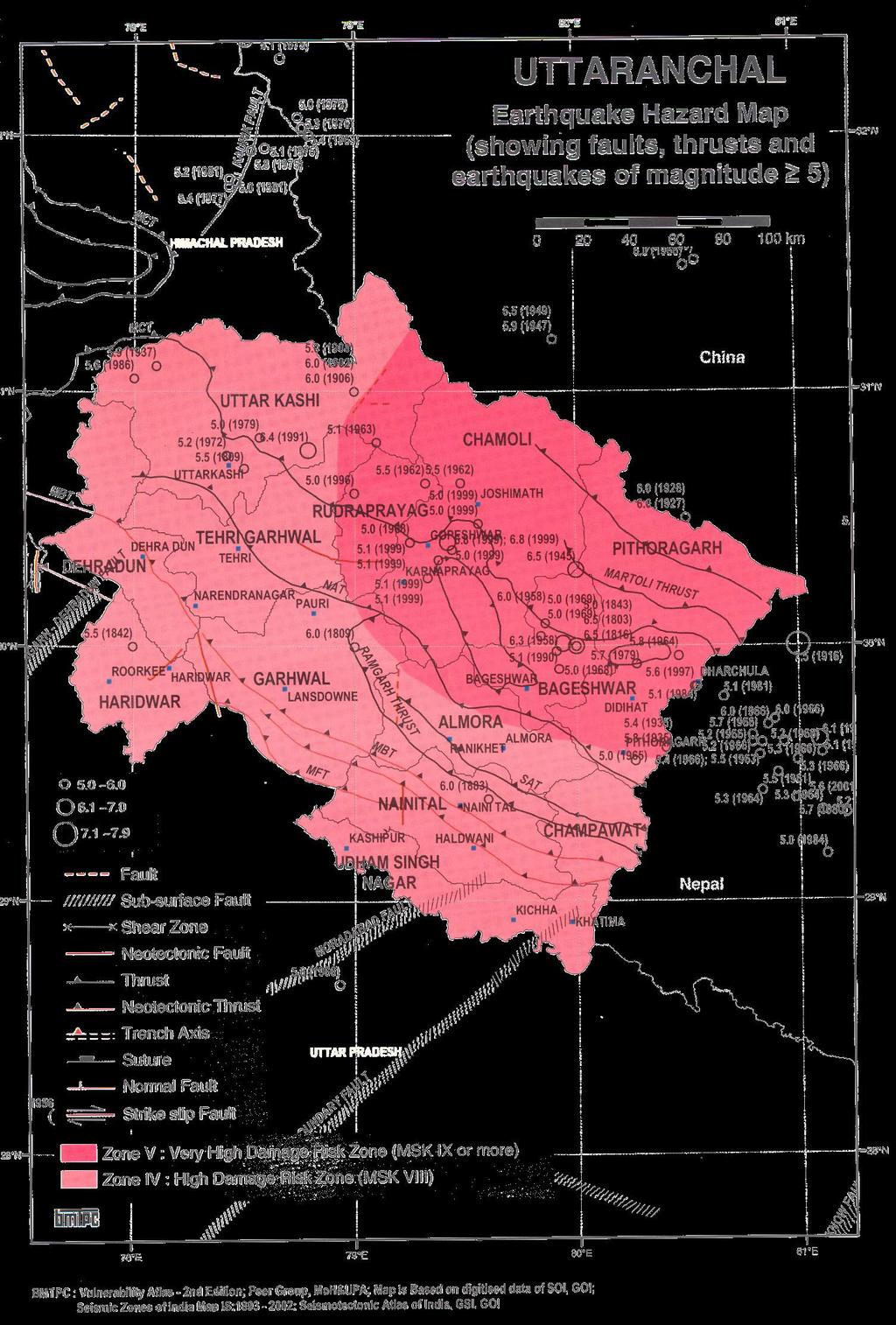
27 very high vulnerability, considering probability of Earth quake, Landslides, Flash flood and Cloud burst etc Vulnerability to Earthquakes (Figure-III) Uttarakhand is located in the seismic gap of the 1934 Bihar Nepal earthquake and 1905 Kangra earthquake, and is categorized as falling in Zone IV and V i.e. state falls in the highest seismic risk zones of the country as been captured in the Vulnerability Atlas Shown in the above figure. Two regional tectonic features in Uttarakhand, which have earthquake potential, are the main central thrust (MCT) & the main Boundary Thrust (MBT). The state of Uttarakhand is highly vulnerable to multi-hazards viz. earthquake, flash-floods, landslides, hailstorms, avalanches, Dam Burst drought, but particularly EARTHQUAKE, as the state falls in the highest 27
28 seismic risk zones of the country i.e. Zone V and IV. The past record of seismic activity in the state and the tectonic profile, probability of a high impact earthquake, can be expected in future Earthquake Hazard Map Based on Seismic Zoning map of India, the State is located in Zone-V & IV of seismic zone as per the seismic code IS: While earthquakes cannot be predicted, a detailed mapping of seismic fault systems located in Himalayan region is shown below. 28
29 (Figure-IV) 29
30 2.3 Vulnerability to Landslides According to geological, topographical and climatic conditions of the area and human factors such as deforestation, unscientific road construction (blastings carried out for road cuttings), constructions of dams or reservoirs, housing schemes, roads, terracing and water intensive agricultural practices on steep slopes etc., implemented without proper environmental impact assessments have increased the intensity and frequency of landslides. The vulnerability of the geologically young, unstable and fragile rocks of the Himalayan state has increased landslides many times in the recent past due to various unscientific developmental activities in Uttarakhand. Almost every year the state is affected by one or more major landslides affecting the society in many ways. Loss of life, damage of houses, roads, means of communication, agricultural land, are some of the major consequences of landslides in Uttarkhand. For this, the state is affected as because there is no other means of transport except roads. Landslides in Uttarakhand 1979 Okhimath landslide: 39 persons died 1986 Landslides at Jakholi in Tehri Garhwal & at Devaldhar in Chamoli: 32 lives lost 1998 Massive landslides in Okhimath a reformed an artificial lake blocking the course of Madhyamaheshwar river (tributary of Mandakini) 109 people dead 30
31 1998 Malpa landslide into river Kali: wiped out Malpa village near Dharchula in Pithoragarh, more than 300 people died Landslides at Budha Kedar and Khetgaon 28 persons died together with 99 cattle 2004 Landslides at Jakholi in Tehri Garhwal & at Devaldhar in Chamoli: 32 lives 2008 Landslides at Amru Band claiming 17 lives Landslides at La Jhakela in Munisyari Tehsil Source: DMMC claiming 43 lives Landslide hazard Zonation mapping Landslides cause widespread damage in the Himalayas. Landslide Hazard Zonation is important to take quick and safe mitigation measures and make strategic planning for the future. GIS based mapping to understand the causes and likelihood of a particular hazard. The need for such landslide hazard information may vary according to the future land use. Landslide hazard zonation mapping at regional level of a large area provides a broad trend of landslide potential zones. These maps are useful for development plans, town planning, master plan for cities, construction of highways etc., land use planning in the sense of avoiding high risk zones & decision making during disaster response. 31

32 (Figure-V) Source : DMMC 2.4 Vulnerability to Floods The State is bestowed with a relatively high average annual rainfall of 1229mm. o Source: Meteorological Department Normally rain arrives in the State in late April and continues up to September. However, the intensity of rainfall increases during the months of June to September Higher rainfall occurring during this period causing floods in low lying areas and erosion of land throughout the State has become a regular feature in the State. 32
33 Deforestation in the Himalayas has increased the severity of floods during the rainy season and reduced steam flows and dried up springs during dry seasons. The increase of soil erosion has reduced the water carrying capacity of the rivers resulting into swallowing of riverbeds leading to floods in the plains. The low lying areas of the State are presented below: Satellite data can be effectively used for mapping and monitoring flood inundated areas, for flood damage assessment, flood hazard zoning and post flood survey of rivers configuration and protection works. River configurations are studied post flood, to assess the status of embankments. Flood Hazard Map based on the Flood Atlas of India prepared by the Central Water Commission. Shows areas likely to flood, other low lying areas are as shown below:- 33
34 (Figure-VI) 34
35 2.5.1 Cloudbursts Though not a regular phenomenon, cloudbursts lead to exceptionally heavy rainfall and sudden flash floods in the mountainous streams and rivers, leading to breaching of banks and overflowing of dams. The State will take appropriate measures to decrease vulnerability and restrict construction to elevated places in the cloudburst prone areas Flash Floods Heavy rainfall over a short period of time results in flash floods, landslides and flooding in some parts of the state. It is because the speed and quantity of inflow of water out pace out drainage systems. Very heavy rainfall in hill tops results in sudden down flow of water at a high speed and may create havoc in habitations down below the hillock. Sometimes, this high speed water evades the traditional path and carries with it Mudflows, Debris flows and Rock falls. Such flows and floods hardly give any time for preparation. Flash floods submerge areas suddenly and remain for a short period of time. Yet its damaging potential is as high as that of the general floods. The most unpredictable aspect of this is that flash floods hardly give any time for preparation Cloudburst in Uttarakhand 2002 Cloudburst in Khetgaon (Pithoragarh) 04 persons died Cloudburst in Ranikhet (Almora): 01 casualty 2007 Cloudburst in Pithoragarh & Chamoli: 23 lives lost 2008 Cloudburst in Pithoragarh: 01 casualty 2009 Massive Cloudburst in Tehsil Munisyari district Pithoragarh: 43 lives lost 2010 Massive Cloudburst Kapkot (Bageshwar) 18 school children were buried alive Massive Cloud burst in Almora: 36 lives lost 35
36 Source: DMMC 2.6 Avalanches Snow avalanches are the sudden slide of large mass of snow down a mountain. There are several factors, which can affect the occurrence of avalanche, including local weather, slope, atmospheric temperature, vegetation; terrain and general snow pack conditions. Different combinations of these factors can create low, moderate and extreme weather conditions. Most avalanches are very dangerous and cause huge loss of life and property. The temperature variation and wind speed are directly proportional to avalanches. Chamoli, Uttarakhand: Two Army officers were killed in an avalanche on September 21, Source: Drought In context of Uttarakhand causes of drought are natural and human activities both. Several types of weather changes have also altered the normal rainfall pattern in an area and cause drought. And in last few years, it has been observed that human activities like soil erosion, deforestation, excessive use of ground water, pollution etc have also caused drought. 2.8 Hailstorms Hailstorms cause heavy damage to crops and vegetation. Secondary hazards like snapping of electric poles due to uprooting of trees, disruption of communication links etc are also attributed to hailstorms. 36
37 2.9 Socio-economic Vulnerability Despite the given hazards in the State, the vulnerability of an area is determined by the capacity of its social, physical, environmental and economic structures to withstand and respond to hazards. An understanding of the socio-economic factors and the capability of the community to cope with disasters would provide an understanding to the development and disaster managers to plan risk reduction against future hazards. Socio Economic behavior is a direct result of marginalization, non access to goods & services, illiteracy & population growth. In some cases, particularly in urban areas, with a high population concentration of the poor, preventive service measures can not reach everybody, resulting in large sections of people being left to face the impact of the hazards with their own means. The State will endeavour to reduce the socio-economic vulnerability poverty alleviation programmes. The preparedness and mitigation initiatives run by the district and block administration will be sensitive to the increased vulnerability of the poor (BPL population) and the socially challenged groups and aim to reduce their vulnerability. Socio-economic Profile Table XIV Population Income per Infant Disabled Disabled (in Lakhs) Person/ Mortality Population Population Annum Rate (%) '000 Live (2011) ( ) Births (2001) (2001) (2007)
38 Table XV District Population Child(Sex- Ratio) (0-6 Age Group) Adult(Sex- Ratio) Literacy Rate (2011) (2001) (2001) (2011) Almora Bageshwar Chamoli Champawat Pauri Garhwal Pithoragarh Rudraprayag Tehri Garhwal Uttarkashi Dehradun Haridwar Nanital U S Nagar Source: uk.gov.in 2.10 Economy and Lack of access to infrastructure Poor economy, low per capital income and significant poverty contribute to the vulnerability of people Poverty is the greatest vulnerability as it forces people to settle in marginal and more vulnerable areas. Uttarakhand is primarily an agricultural state although its share in the country s total area and production is very small. The contribution of agriculture to the state s domestic product is about per cent and the population dependent on agriculture for their livelihood is about
39 per cent. The contribution of Uttrakhand to the country s total food grain and sugarcane production is negligible. Average Income per person /annum is which low as compared to India's figures which is (Table-I). The State is handicapped due to inadequate, irrigation facilities, insufficient storage facilities, insufficient marketing/credit institutions and poor infrastructure. Basic services like health, market, are also inadequate in certain hilly and remote areas. Poor accessibility to infrastructure increases the vulnerability of the population during Disasters Education Education is a basic requirement that helps improve the coping capacities of the population. The State s literacy rate is still low at (Table-II) and it is lower for women 70.70%. Inadequate education becomes a strong disadvantage for exploring alternative occupational or employment opportunities High Mortality The health care system and health infrastructure of the State are inadequate and add to the vulnerability of people to the disasters. (Table-II) 2.13 Housing Housing Vulnerability Tables A systematic study for the whole country has been taken up by Building Materials Technology Promotion Council in the form of the. Vulnerability Atlas. One of the important aspects of Vulnerability Atlas is housing vulnerability tables Taking guidance from this work, the types of housing, as existing in each district has been taken from the Census of 39
40 India, 1991 and categorized from vulnerability consideration. The housing infrastructure and its vulnerability to hazard have been categorically analyzed in this table. The vulnerability atlas has tabular details of the house types, risk of damage to house types, damage risk levels for earthquakes, floods. Hence given the intensity of hazard one can analyze the effect of the same on housing infrastructure for the state of Uttarkhand (Figures of Vulnerability of houses in the State given in the Annexure) Quality and design specifications of houses as well as materials used for housing, particularly for roofing and walling, have a bearing on the vulnerability of houses to earthquakes, landslides, floods and fires. The buildings/house types in the State, for which Census has been done, are 2,566,282 as given in the Table-III. In The Housing category - Wall Types Consists of 56% (Mud, Unburnt Brick Wall and Stone Wall), 37.9% Burnt Brick Walls, 2.1% concrete and wood wall and 4.0% Walls are of Other Materials. Where (Mud, Unburnt Brick Wall and Stone Wall) - Category A (Burnt Brick Walls) - Category B These two category houses are vulnerable & likely to get severe damage including collapse in moderate intensity of earthquakes. The concrete and wood frame houses placed in Category C account for 2.1% and prove to be much better with only a few collapses. In The Housing category - Roof Types Consists of 19.2% (Light Weight Sloping Roof), 18.3% (Heavy Weight Sloping Roof) 62.5% are Flat Roofs. 40
41 Table XVI Wall Types &o of Houses % Of houses (Mud, Unburnt Brick Wall and Stone 1,437,439 56% Wall) (Burnt Brick Walls) 97, % The concrete and wood frame 54, % houses, Other category of houses 101, Total Vulnerable houses Total no of houses 2,409, Source: Vulnerability Atlas of India 2.14 Gender discrimination Even though women constitute nearly half of the population, they are more vulnerable to disasters because of socio-cultural barriers to various forms of livelihood opportunities People needing special care Pregnant women, aged & sick are the most vulnerable during and after disasters because of their physical vulnerability and also their lack of capacity of earning their livelihood 2.16 Live Stocks Live stock at times is the poor man's only asset (Table-IV).Unlike other forms of property, livestock loss is irreplaceable. The contingent issue here is immediate provision of alternate occupation, which is the most difficult part of rehabilitation. Shortage of food affects livestock before it starts to affect human beings. Malnutrition & disease reduce their productive capacity, which results in reduced income for the farmer. Disease among live stock also spread during disasters.these still remain 41
42 less considered aspects of disaster management. Insurance is the best option but it still needs to be duly considered in Uttarakhand. Live Stock In Uttarakhand Table XVII S &o. Classification &os. /Production 1. Total Live Stock (2007) Other Small Animals (2007) Milk Production (Kgs) per day/animal ( ) (a) Cow (b) Buffalo 4. Eggs (Nos.) per hen /year ( ) 5. Wool(kgs)per sheep/year ( ) Source: uk.gov.in Conclusions Analysis shows that various locations in Uttarakhand are vulnerable to different disasters in varied degrees. Preparedness & mitigation plans, therefore will have to be evolved locally to reduce the impact of the disasters. While evolving such areas specific preparedness & mitigation plans types of vulnerabilities will essentially define the level of preparation & mitigation strategies. These strategies will have to be concentrated more towards the social & economically backward communities as against the vulnerability of the overall system. 42
43 CHAPTER III Preventive Measures 3.1 Early Warning and Dissemination systems DMMC will be the main focal point responsible for coordinating early warning, along with the relevant technical agencies and Technical Committees, its dissemination and for ensuring last mile dissemination of same. The State Emergency Operation Centre of the DMMC will be in constant coordination with all technical agencies responsible for natural and man-made hazards, and in instances of any imminent disaster, it will take action to inform the responsible officers for onward communication to the sub-levels and communities. Key Responsibilities: Establish coordination with the local technical agencies responsible for forecasting different hazards, Establish a reliable communication system (Telephones, Radio Communication etc.) from technical agencies to the State Emergency Operating Centre (SEOC) and to Provincial / District Control Rooms directly or through (DEOC). Ensure redundancy by having alternative communication systems in place in case of breakdowns in the main system. Have the system established with media and ensure dissemination of information through same. Create awareness among communities and all concerned including Police on the communication system in use for early warning and what immediate actions to be taken, especially on rapid onset disasters. 43
44 3.2 State Emergency Operation Centre (Department of Disaster Management) Communication &etwork Everyday testing of all the communication equipments in SEOC, which is a major component of the State Emergency Operation Centre. VSAT DMS HUB VSAT NIC SATELLITE PHONE DMS HUB New Delhi NIC Dehradun District Satellite Phone MHA/NIDM/NDMA 13 Districts NIC Centre (Other Departments) (Figure-VIa) 44
45 3.2.2 Police Wireless Set:- Repeater Gama City D.C.R Kumaon Ch-12 Ch-7 Ch-3 Ch-3 (Range) (Garhwal Mandal) (Home Control Dehradun City Ch-35 / Kumaon Mandal) (Figure-VIb) In the case of a natural calamity/ Incident the Preliminary Information received from the Police Wireless Set and Immediately after Initial Action Taken Report is prepared based on wireless/ telecommunication opinion. It is sent to all the concerned officers including Hon'ble Chief Minister, Secretaries, Information Directorate, Commissioners, Departmental Nodal Officers, MHA, NIDM, GSI, and Media also Alert and Information System (SMS Software) It is a very effective alert information system during the incident. This system plays a very vital role in dissemination of information w.r.t. incident in detail; it includes the following format of reporting: Type of Incident -{ Road Accident/ Natural calamity/ Earthquake} Place of occurrence/block/tehsil/district. Time of occurrence, Date. Total Persons Expected casualties Injured/Seriously Injured 45
46 Time to time dissemination of detailed information on the incidence through SMS. All messages are communicated to print media and electronic media. Alert and Information System State Level Official Ministers Secretariat Officers Departmental Nodal Internal Staff Media Officers District level Officials Administrative Group Police Department Medical Group Distt Info.officer District Magistrate D G C.M.O/C.M.S Info. Directorate ADM IG Garhwal/IG Kumaon 108 EMRI Electronic/ Media SDM S.S.P/S.P District Hospital Tehsildar Thana Incharge PHC/CHC CRA/ACRA Chowki Incharge/S.O Patwari/ Kanoogo (Figure-VIc) 46
47 3.3 Early warning System The Early Warning System purpose is mainly to prepare for the danger and act accordingly to mitigate against or avoid it. During the Monsoon Season State Emergency Operation Centre disseminates the monsoon season reports; it includes the following reports that have been has been gathered from the various departments and resources-: Monsoon Season Meteorological Dept (Weather Forecast) (Rainfall Report) Central Water Commission (Daily water level) (Flood Forecast) Rainfall Report State Emergency Operation Centre disseminates the Rainfall Report of four stations (Dehradun, Pantnagar, Muketshwar, and New Tehri) to MHA, which is received from the Dehradun Meteorological Department. Weather Forecasting is one of the important tasks of Meteorological Department, we all are aware that Uttarakhand state is very prone and is sensitive in the cases of Natural Disaster. During the Monsoon season, the flash floods and heavy rainfall gets increased. The Daily Report on rainfall and floods is being sent to Joint Secretary (Disaster Management) and Disaster Control Room, Ministry of Home Affairs from 1st June, to 30th September. (Annexure Attached) 47
48 Prevention 3.4 Prevention Prevention is an important aspect of disaster management. Prevention may be described as measures designed to prevent natural phenomenon from causing or resulting in disaster or other related emergency situations.clearly, not all emergencies can be prevented, so the concept is taken to have a much broader meaning. Prevention actions concern the formulation of long-range policies and programs to prevent or eliminate the occurrence of disasters. Prevention involves: Identification of hazards; Determination of the levels of risk associated with those hazards. Taking action to reduce potential loss or damage to life, property an the environment. Prevention strategies include legislation and its enforcement, e.g., land use codes, safety regulations, building codes, hygiene, disease control, flood management, etc; Soil conservation, watershed management. Dissemination of warning. Failsafe Communication network. Strengthening of environmental management and restoration measures. Training, capacity building and awareness building; Financial protection: e.g. insurance Community Based Disaster Preparedness Plans, public education and warning systems. Strengthening of Public infrastructure. 48
49 Mitigation Strategy 3.5 Mitigation Strategy Pre-disaster planning consists of activities such as disaster mitigation and disaster preparedness. Disaster mitigation focuses on the hazard that causes the disaster and tries to reduce its effects. Mitigation is being recognized as an integral component of sustainable development, so that communities are likely to recover more quickly from the Impacts of the disasters. Objectives of the mitigation strategy:- To substantially increase public awareness of disaster risk management for safer communities to live in and work. To develop a strategy for reducing the impacts of disaster on community, facility or agency. The Mitigation strategy is broadly classified into structural and nonstructural mitigation measures. The main components of structural mitigation strategy are as follows: Structural Mitigation Structural mitigation includes physical measures and standards such as building codes, materials specifications, and performance standards for the construction of new buildings; the retrofitting of existing structures to make them more hazard-resistant. Structural mitigation is more complex than the non-structural mitigation, and usually has a higher associated cost. Mitigation plan for the State shall include all the activities that prevent a hazard or lessen the damaging affects of unavoidable hazards. 49
UTTRAKHAND MICRO, SMALL & MEDIUM ENTERPRISE POLICY-2015
 UTTRAKHAND MICRO, SMALL & MEDIUM ENTERPRISE POLICY-2015 Government of Uttarakhand has sanctioned the MSME Policy-2015 for promoting investment in the MSME Sector through Investment Promotion as well as
Disaster Management Initiative
 DISASTER MANAGEMENT 71 Disaster Management Initiative The Government of Maharashtra (GOM) supported the development of a comprehensive disaster management program that included the development of response
Format for Preliminary Project Report (PPR)
") Integrated Watershed Management Programme Format for Preliminary Project Report (PPR) Department of Land Resources, Ministry of Rural Development, Government of India 1 Format for Preliminary Project Report
Integrated Watershed Management Programme Format for Preliminary Project Report (PPR) Department of Land Resources, Ministry of Rural Development, Government of India 1 Format for Preliminary Project Report
North Lombok District, Indonesia
 North Lombok District, Indonesia Local progress report on the implementation of the 10 Essentials for Making Cities Resilient (2013-2014) Mayor: H. Djohan Sjamsu, SH Name of focal point: Mustakim Mustakim
ON-GOING EXTERNALLY AIDED PROJECTS
 ON-GOING EXTERNALLY AIDED PROJECTS The State Government has given a very high priority for the Externally Aided Projects (EAPs) in the resource mobilization strategy of the State. EAPs play an important
MGS UNIVERSITY BIKANER
 MGS UNIVERSITY BIKANER Scheme of Teaching and Examination and Courses of Study (Syllabus) For Post Graduate Diploma in Disaster Management - 2016 Scheme of Teaching and Examination and Courses of Study
Chapter -3 RESEARCH METHODOLOGY
 Chapter -3 RESEARCH METHODOLOGY i 3.1. RESEARCH METHODOLOGY 3.1.1. RESEARCH DESIGN Based on the research objectives, the study is analytical, exploratory and descriptive on the major HR issues on distribution,
BLINN COLLEGE ADMINISTRATIVE REGULATIONS MANUAL
 BLINN COLLEGE ADMINISTRATIVE REGULATIONS MANUAL SUBJECT: Emergency Response Plan EFFECTIVE DATE: November 1, 2014 BOARD POLICY REFERENCE: CGC PURPOSE To prepare Blinn College for three classifications
WFP Support to Wajir County s Emergency Preparedness and Response, 2016
 4 WFP Support to Wajir County s Emergency Preparedness and Response, 2016 OCTOBER 2016 Emergency preparedness and response programmes are now a shared function between Wajir County Government and the national
Persons Affected with Leprosy Homes 4 No. of PAL living in these homes 135
 DISTRICT PROFILE NAINITAL (2008) Introduction Nainital, the 'Lake District' of India is a valley having a pear-shaped lake of two miles in circumference, and surrounded by mountains like Naina (2,615 m),
(ii) P&C Branch. Publicity in national media at Delhi based on material received from the State Directorate.
 P&C Branch. Publicity in national media at Delhi based on material received from the State Directorate.") Role and Tasks of NCC 1. Broad bases responsibilities at NCC are enumerated below. HQ DG NCC will coordinate relief efforts and advise State Directorates on regularization of ration, FOL and stores. Main
Role and Tasks of NCC 1. Broad bases responsibilities at NCC are enumerated below. HQ DG NCC will coordinate relief efforts and advise State Directorates on regularization of ration, FOL and stores. Main
Disaster Management in India
 Fourth National Seminar Disaster Management in India March 21-22, 2018 Department of Public Administration Maulana Azad National Urdu University Hyderabad-Telangana About the University: Maulana Azad National
DEMOCRATIC PEOPLE S REPUBLIC OF KOREA
 DEMOCRATIC PEOPLE S REPUBLIC OF KOREA Assessment of Capacities using SEA Region Benchmarks for Emergency Preparedness and Response SEA-EHA-22-DEMOCRATIC PEOPLE S REPUBLIC OF KOREA Assessment of Capacities
CORPORATE SOCIAL RESPONSIBILITY POLICY March, 2017 Version 1.2
 CORPORATE SOCIAL RESPONSIBILITY POLICY March, 2017 Version 1.2 Name of document Corporate Social Responsibility Policy Policy Version 1.2 Issued by CSR Committee Amendment date 22.03.2017 Effective Date
INDONESIA. Assessment of Capacities using SEA Region Benchmarks for Emergency Preparedness and Response
 INDONESIA Assessment of Capacities using SEA Region Benchmarks for Emergency Preparedness and Response SEA-EHA-22-INDONESIA Assessment of Capacities using SEA Region Benchmarks for Emergency Preparedness
ANNEX R SEARCH & RESCUE
 ANNEX R SEARCH & RESCUE Hunt County, Texas Jurisdiction Ver. 2.0 APPROVAL & IMPLEMENTATION Annex R Search & Rescue NOTE: The signature(s) will be based upon local administrative practices. Typically, the
DELAWARE COUNTY COMPREHENSIVE EMERGENCY MANAGEMENT PLAN RISK REDUCTION
 DELAWARE COUNTY COMPREHENSIVE EMERGENCY MANAGEMENT PLAN Section II RISK REDUCTION A. Designation of County Hazard Mitigation Coordinator 1. The Delaware County Planning Director has been designated by
Request for Proposal
 Request for Proposal on Impact Assessment of ITC s Watershed Development Programmes implemented in partnership with NABARD in select districts of Andhra Pradesh Districts Guntur, Prakasam Deadline for
Nepal Humanitarian Situation and ACF response update n 3, May 28, 2015
 Nepal Humanitarian Situation and ACF response update n 3, May 28, 2015 Context and humanitarian situation ACF visiting affected neighborhood of Balaju in Kathmandu. 2015 Daniel Burgui Iguzkiza / ACF One
CHAPTER 2 PLANNING PROCESS
 CHAPTER 2 PLANNING PROCESS The 2011 Wyoming Multi-Hazard Mitigation Plan (Plan) is the product of cooperation among local, state, and federal organizations over a period of several years. The State directed
1) What type of personnel need to be a part of this assessment team? (2 min)
 What type of personnel need to be a part of this assessment team? (2 min)") Student Guide Module 2: Preventive Medicine in Humanitarian Emergencies Civil War Scenario Problem based learning exercise objectives Identify the key elements for the assessment of a population following
Student Guide Module 2: Preventive Medicine in Humanitarian Emergencies Civil War Scenario Problem based learning exercise objectives Identify the key elements for the assessment of a population following
Kampala, Uganda. Local progress report on the implementation of the Hyogo Framework for Action ( )
") Kampala, Uganda Local progress report on the implementation of the Hyogo Framework for Action (2013-2014) Name of focal point: Emmanuel Serunjoji Organization: Kampala Capital City Authority Title/Position:
Kampala, Uganda Local progress report on the implementation of the Hyogo Framework for Action (2013-2014) Name of focal point: Emmanuel Serunjoji Organization: Kampala Capital City Authority Title/Position:
Tanjung Pinang, Indonesia
 Tanjung Pinang, Indonesia Local progress report on the implementation of the 10 Essentials for Making Cities Resilient (2013-2014) Name of focal point: Yusniar Nurdin Organization: BNPB Title/Position:
NSCI-UNEP-EC Project on DISASTER RISK REDUCTION IN TOURISM DESTINATION, Kanniyakumari, India. Activity A 4 ASSESSMENT OF LOCAL DISASTER PREPAREDNESS
 NSCI-UNEP-EC Project on DISASTER RISK REDUCTION IN TOURISM DESTINATION, Kanniyakumari, India Annexure - 1 Activity A 4 ASSESSMENT OF LOCAL DISASTER PREPAREDNESS 1.0 Introduction: Kanniyakumari is a small
Institutional Arrangements for Disaster Management (DM)
") Institutional Arrangements for Disaster Management (DM) This section would describe the organizational structure that exists at the District, Block, Gram Panchayat, Municipality and community levels for
Institutional Arrangements for Disaster Management (DM) This section would describe the organizational structure that exists at the District, Block, Gram Panchayat, Municipality and community levels for
DRAFT New Delhi City Resilience Action Plan
 DRAFT New Delhi City Resilience Action Plan Calendar Year (CY) 2014-2015 City/ LG Name Country Focal Point New Delhi, India Breakdown of Objectives, Activities and Indicators for Each of MCR Campaign 10
GoI-UNDP Disaster Risk Management Programme. Project Management Board (PMB) GoI-UNDP Disaster Risk Management Programme [ ] Agenda Notes
![GoI-UNDP Disaster Risk Management Programme. Project Management Board (PMB) GoI-UNDP Disaster Risk Management Programme [ ] Agenda Notes](/thumbs/83/87290884.jpg "GoI-UNDP Disaster Risk Management Programme. Project Management Board (PMB) GoI-UNDP Disaster Risk Management Programme [ ] Agenda Notes") 3 rd Meeting of the Project Management Board (PMB) GoI-UNDP Disaster Risk Management Programme [2002-2007] Agenda Notes Part I 21 st December, 2004, New Delhi NDM Division, Ministry of Home Affairs, North
3 rd Meeting of the Project Management Board (PMB) GoI-UNDP Disaster Risk Management Programme [2002-2007] Agenda Notes Part I 21 st December, 2004, New Delhi NDM Division, Ministry of Home Affairs, North
Delay in response may result in increased loss of lives and livelihoods.
 Islamic Republic of Afghanistan National Disaster Management Authority (ANDMA) 26-29 August 2013 1 Delay in response may result in increased loss of lives and livelihoods. 2 Introduction Afghanistan has
ADAMS COUNTY COMPREHENSIVE EMERGENCY MANAGEMENT PLAN HAZARDOUS MATERIALS
 ADAMS COUNTY COMPREHENSIVE EMERGENCY MANAGEMENT PLAN EMERGENCY SUPPORT FUNCTION 10A HAZARDOUS MATERIALS Primary Agencies: Support Agencies: Adams County Emergency Management Fire Departments and Districts
Consultation Meeting on the Study of Early Warning System - Thiruvananthapuram. Date: 19 th March, 2014 Venue: ILDM, PTP Nagar, Thiruvananthapuram
 Consultation Meeting on the Study of Early Warning System - Thiruvananthapuram Date: 19 th March, 2014 Venue: ILDM, PTP Nagar, Thiruvananthapuram UNDP has given national consultation to TARU Leading Edge
Pan-American Disaster Response Unit
 Pan-American Disaster Response Unit (Appeal 01.25/2001) Click on figures to go to budget In CHF In CHF 1. Disaster Preparedness 1,672,000 Total 1,672,000 Pan-American Disaster Response Unit (PADRU) Background
<3& =&, >()$)2&+?$'$4&#&'2 *0+#$2(0' B-$' 60+ <&3+$' C(27 "#$%&'!
$)2&+?$'$4&#&'2 *0+#$2(0' B-$' 60+ <&3+$' C(27 #$%&'!") !"#$%& '()%)*"$ +(*(,%*(-& %&. +%&%,"/"&* 0$,%&(1%*(-& ()$)2&+?$'$4&#&'2 ?
!"#$%& '()%)*"$ +(*(,%*(-& %&. +%&%,"/"&* 0$,%&(1%*(-& ()$)2&+?$'$4&#&'2 ?
ICT and Disaster Risk Reduction Division ESCAP
 E-RESILIENCE FOR SUSTAINABLE DEVELOPMENT Ms. Atsuko Okuda, Chief IDS ICT and Development Section ICT and Disaster Risk Reduction Division ESCAP Introduction What is E-Resilience? ICT plays a pivotal role
PLAN (SIMP) AND REHABILATION AND RESETTLEMENT STUDIES. Date of Submission:- 5/11/2016 up to 17:00Hrs
 AND REHABILATION AND RESETTLEMENT STUDIES. Date of Submission:- 5/11/2016 up to 17:00Hrs") INVITING EXPRESSION OF INTEREST (REVISED) MAHAGENCO Tender Specification No. CE(C) -III./GP/T- 27 / 2016-17 Name of work: Gare Palma Coal mine project, Dist Raigarh ( Chhattisgarh) - Inviting expression
INVITING EXPRESSION OF INTEREST (REVISED) MAHAGENCO Tender Specification No. CE(C) -III./GP/T- 27 / 2016-17 Name of work: Gare Palma Coal mine project, Dist Raigarh ( Chhattisgarh) - Inviting expression
Emergency Operations Plan
 Emergency Operations Plan 1 I. General Information A. Purpose The purpose of the Ursinus College Emergency Operations Plan (EOP) is to provide a management structure, key responsibility, assignments and
Dumai, Indonesia. Local progress report on the implementation of the 10 Essentials for Making Cities Resilient ( )
") Dumai, Indonesia Local progress report on the implementation of the 10 Essentials for Making Cities Resilient (2013-2014) Name of focal point: Yusniar Nurdin Organization: BNPB Title/Position: Technical
Dumai, Indonesia Local progress report on the implementation of the 10 Essentials for Making Cities Resilient (2013-2014) Name of focal point: Yusniar Nurdin Organization: BNPB Title/Position: Technical
United Nations/India Workshop
 United Nations/India Workshop Use of Earth Observation Data in Disaster Management and Risk Reduction: Sharing the Asian Experience Organized by United Nations Office for Outer Space Affairs (UNOOSA) Indian
The preparation and integration of Turkey s National Disaster Response Plan
 Disaster Management and Human Health Risk IV 1 The preparation and integration of Turkey s National Disaster Response Plan F. Oktay Republic of Turkey Prime Ministry Disaster and Emergency Management Authority,
Table 1: Types of Emergencies Potentially Affecting Urgent Care Centers o Chemical Emergency
 Developing an Emergency Preparedness Plan Alan A. Ayers, MBA, MAcc Content Advisor, Urgent Care Association of America Associate Editor, Journal of Urgent Care Medicine Vice President, Concentra Urgent
INDIA INDONESIA NEPAL SRI LANKA
 INDIA INDONESIA NEPAL SRI LANKA India Building back better: Gujarat in the aftermath of the 2001 earthquake Background A massive earthquake shook India s Gujarat state in January 2001. It affected not
Kampala, Uganda. Local progress report on the implementation of the 10 Essentials for Making Cities Resilient ( )
") Kampala, Uganda Local progress report on the implementation of the 10 Essentials for Making Cities Resilient (2013-2014) Name of focal point: Emmanuel Serunjoji Organization: Kampala Capital City Authority
Kampala, Uganda Local progress report on the implementation of the 10 Essentials for Making Cities Resilient (2013-2014) Name of focal point: Emmanuel Serunjoji Organization: Kampala Capital City Authority
EMERGENCY SUPPORT FUNCTION (ESF) 3 PUBLIC WORKS AND ENGINEERING
 3 PUBLIC WORKS AND ENGINEERING") EMERGENCY SUPPORT FUNCTION (ESF) 3 PUBLIC WORKS AND ENGINEERING Primary Agency: Chatham County Department of Public Works Support Agencies: Chatham Emergency Management Agency Chatham County Engineering
EMERGENCY SUPPORT FUNCTION (ESF) 3 PUBLIC WORKS AND ENGINEERING Primary Agency: Chatham County Department of Public Works Support Agencies: Chatham Emergency Management Agency Chatham County Engineering
A Post-Tsunami Experience from Sri Lanka. General Secretary. Sri Lanka. Island in the. 65,610 km² 20 million people. Density - 305/km² 790/mi²
 Building Resilient Communities; A Post-Tsunami Experience from Sri Lanka Dr.Vinya Ariyaratne General Secretary Sarvodaya Shramadana Movement Island in the Indian Ocean 65,610 km² 20 million people Population
Alabama Course of Study SEVENTH GRADE Geography
 McDOUGAL LITTELL correlated to the Alabama Course of Study SEVENTH GRADE Geography McDougal Littell World Cultures and Geography: Eastern Hemisphere correlated to the Alabama Course of Study SEVENTH GRADE
(Pyidaungsu Hluttaw Law (2015) No. ) 1376ME The Pyidaunsu Hluttaw (the Union Parliament) now therefore promulgates this law.
 No. ) 1376ME The Pyidaunsu Hluttaw (the Union Parliament) now therefore promulgates this law.") Population Control Healthcare Law (draft) (Pyidaungsu Hluttaw Law (2015) No. ) 1376ME 2015 The Pyidaunsu Hluttaw (the Union Parliament) now therefore promulgates this law. Chapter I Title and Definition
Population Control Healthcare Law (draft) (Pyidaungsu Hluttaw Law (2015) No. ) 1376ME 2015 The Pyidaunsu Hluttaw (the Union Parliament) now therefore promulgates this law. Chapter I Title and Definition
Digital Bangladesh Strategy in Action
 Digital Bangladesh Strategy in Action Introduction While Awami League s Charter for Change announced the concept of Digital Bangladesh as an integral component of Vision 2021, the budget 2009 10 speech
AFGHANISTAN HEALTH, DISASTER PREPAREDNESS AND RESPONSE. CHF 7,993,000 2,240,000 beneficiaries. Programme no 01.29/99. The Context
 AFGHANISTAN HEALTH, DISASTER PREPAREDNESS AND RESPONSE CHF 7,993,000 2,240,000 beneficiaries Programme no 01.29/99 The Context Twenty years of conflict in Afghanistan have brought a constant deterioration
CORPORATE SOCIAL RESPONSIBILITY POLICY HI-TECH GEARS LIMITED
 CORPORATE SOCIAL RESPONSIBILITY POLICY OF HI-TECH GEARS LIMITED 1 PREAMBLE 1.1 Concept Corporate Social Responsibility is a Company s commitment to its stakeholders to conduct business in an economically,
The Community Flood Management Programme (CFMP) in South Asia: Pilot Phase (Bangladesh, India, Nepal) WMO/GWP APFM
 in South Asia: Pilot Phase (Bangladesh, India, Nepal) WMO/GWP APFM") The Community Flood Management Programme (CFMP) in South Asia: Pilot Phase WMO/GWP APFM Q. K. Ahmad Regional Coordinator, CFMP, South Asia Chairman, Bangladesh Unnayan Parishad (BUP), Dhaka 1 The goals
The Community Flood Management Programme (CFMP) in South Asia: Pilot Phase WMO/GWP APFM Q. K. Ahmad Regional Coordinator, CFMP, South Asia Chairman, Bangladesh Unnayan Parishad (BUP), Dhaka 1 The goals
Supporting Nepal to Build Back Better
 OCTOBER 2015 Empowered lives. Resilient nations. Supporting Nepal to Build Back Better Key Achievements in UNDP s Earthquake Response UNDP Nepal 1 2 Supporting Nepal to Build Back Better Context Two devastating
North Vancouver, Canada
 North Vancouver, Canada Local progress report on the implementation of the Hyogo Framework for Action (2013-2014) Mayor: Darrell Mussatto Name of focal point: Dorit Mason Organization: North Shore Emergency
Structural Flood Mitigation
 Community Emergency Preparedness Fund Structural Flood Mitigation 1. Introduction 2018 Program & Application Guide The Community Emergency Preparedness Fund (CEPF) is a suite of funding programs intended
DISASTER MANAGEMENT PLAN
 DISASTER MANAGEMENT PLAN Purpose This Allen University Disaster Management Plan (AUDMP) will be the basis to establish policies and procedures, which will assure maximum and efficient utilization of all
VERMONT S RESILIENCE PROGRESS REPORT ROADMAP. August 20, 2015 BACKGROUND WHAT IS RESILIENCE? TRACKING OUR PROGRESS.
 PROGRESS REPORT August 20, 2015 VERMONT S ROADMAP TO RESILIENCE BACKGROUND Preparing for Natural Disasters and the Effects of Climate Change in the Green Mountain State In December 2013, following an 18-month
H.L. Tissera. Sri Lanka
 Sentinel Asia System Operation for Disaster Management in Sri Lanka JPT Meeting, July 2011 - Malaysia H.L. Tissera Additional Secretary Ministry of Disaster Management Sri Lanka Contents 1. Overview of
NABARD Consultancy Services Private Limited (NABCONS) Corporate Social Responsibility (CSR) Policy
 Corporate Social Responsibility (CSR) Policy") NABARD Consultancy Services Private Limited (NABCONS) Corporate Social Responsibility (CSR) Policy 1 1. PREAMBLE 1.1 Corporate Social Responsibility calls upon the corporate entities to serve to the interests
NABARD Consultancy Services Private Limited (NABCONS) Corporate Social Responsibility (CSR) Policy 1 1. PREAMBLE 1.1 Corporate Social Responsibility calls upon the corporate entities to serve to the interests
ESF 14 - Long-Term Community Recovery
 ESF 4 - Long-Term Community Recovery Coordinating Agency: Harvey County Emergency Management Primary Agency: Harvey County Board of County Commissioners Support Agencies: American Red Cross Federal Emergency
WORLD HEALTH ORGANIZATION
 WORLD HEALTH ORGANIZATION EXECUTIVE BOARD EB115/6 115th Session 25 November 2004 Provisional agenda item 4.3 Responding to health aspects of crises Report by the Secretariat 1. Health aspects of crises
Madhya Pradesh Integrated Urban Sanitation Programme Guidelines, 2009
 Madhya Pradesh Integrated Urban Sanitation Programme Guidelines, 2009 This document is available at ielrc.org/content/e0925.pdf Note: This document is put online by the International Environmental Law
Persons affected by leprosy homes No. of persons affected by leprosy living in these homes Not Applicable
 DISTRICT PROFILE HARDOI (2008) Introduction is situated in the central part of Uttar Pradesh (UP). Geographically, it is the largest district of Uttar Pradesh. Agriculture is the main source of income
THE IMPRESS GREEK-BULGARIAN CROSS-BORDER TABLE TOP EXERCISE
 P a g e 1 THE IMPRESS GREEK-BULGARIAN CROSS-BORDER TABLE TOP EXERCISE The final system of the EU-funded IMPRESS Project was successfully tested and validated in the context of a cross-border Table Top
Ministry of Home Affairs Disaster Management Division National Emergency Response Centre (NERC)
") Ministry of Home Affairs Disaster Management Division National Emergency Response Centre (NERC) **** Situation report on Heavy Rain fall in Kerala, Karnataka, Assam, West Bengal, Uttar Pradesh, Uttarakhand
Ministry of Home Affairs Disaster Management Division National Emergency Response Centre (NERC) **** Situation report on Heavy Rain fall in Kerala, Karnataka, Assam, West Bengal, Uttar Pradesh, Uttarakhand
Democratic Republic of the Congo: Floods in Kinshasa
 Democratic Republic of the Congo: Floods in Kinshasa DREF operation n MDRCD002 GLIDE n FL-2007-000197 COD 8 July, 2009 The International Federation s Disaster Relief Emergency Fund (DREF) is a source of
SUPPORTING NEPAL FOR EARTHQUAKE RECOVERY
 SUPPORTING NEPAL FOR EARTHQUAKE RECOVERY On 25th April 2015, a magnitude of 7.8 earthquake (source: USGS) struck Nepal with epicenter Gorkha District which is approximately 77km northwest of Kathmandu,
ALTERNATIVE SOURCES OF FUNDING FOR
 January 2017 ALTERNATIVE SOURCES OF FUNDING FOR Flood-Related General Water Management Water Supply Projects The following inventory contains information about a variety of funding programs offered by
TILLAMOOK COUNTY, OREGON EMERGENCY OPERATIONS PLAN ANNEX R EARTHQUAKE & TSUNAMI
 TILLAMOOK COUNTY, OREGON EMERGENCY OPERATIONS PLAN ANNEX R EARTHQUAKE & TSUNAMI I. PURPOSE A. Tillamook coastal communities are at risk to both earthquakes and tsunamis. Tsunamis are sea waves produced
Corporate Social Responsibility Policy *********
 Corporate Social Responsibility Policy ********* INDEX Item No. SUBJECT Page No. I. Introduction II. III. IV. Preamble Objectives CSR Committee V. Activities/ Areas of focus on CSR VI. VII. VIII. IX. Allocation
The Standing Orders shall be followed during Normal times, Precautionary and Warning stage, Disaster stage and Post-disaster stage.
 Standing Order: 1. Background and definition: Background: The Standing Orders have been prepared with the avowed objective of making the concerned persons understand their duties and responsibilities regarding
MANDAN FIRE DEPARTMENT STANDARD OPERATION PROCEDURES
 GENERAL ORDER # 105.03 DATE: September 18, 1998 Incident Command System 1 of 22 OBJECTIVE: To establish a procedure that will provide for a uniform Incident Management System. SCOPE: The Incident Command
CENTRAL AND EASTERN EUROPE AND THE COMMONWEALTH OF INDEPENDENT STATES. Tajikistan
 CENTRAL AND EASTERN EUROPE AND THE COMMONWEALTH OF INDEPENDENT STATES Tajikistan In 2010, a string of emergencies caused by natural disasters and epidemics affected thousands of children and women in Tajikistan,
Part 1.3 PHASES OF EMERGENCY MANAGEMENT
 Part 1.3 PHASES OF EMERGENCY MANAGEMENT Four primary phases of emergency management are outlined below, relating to campus mitigation, preparedness, response and recovery activities occurring before, during,
Duties & Responsibilities of the EMC
 Duties & Responsibilities of the EMC Berks County Department of Emergency Services Direct Link Technology Center 2561 Bernville Rd. Reading, PA 19605 (610) 374-4800 Phone (610) 374-8865 Fax http://www.berkdes.com
I. Improving disaster risk preparedness in the ESCAP region ($621,900)
") ESCAP I. Improving disaster risk preparedness in the ESCAP region ($621,900) Background 45. Disaster loss is on the rise with grave consequences for the survival, dignity and livelihood of individuals,
ESCAP I. Improving disaster risk preparedness in the ESCAP region ($621,900) Background 45. Disaster loss is on the rise with grave consequences for the survival, dignity and livelihood of individuals,
AVAILABILITY AND UTILIZATION OF SOCIAL SERVICES (EDUCATION AND HEALTH) BY RURAL COMMUNITY IN DISTRICT CHARSADDA
 BY RURAL COMMUNITY IN DISTRICT CHARSADDA") Sarhad J. Agric. Vol.25, No.1, 2009 AVAILABILITY AND UTILIZATION OF SOCIAL SERVICES (EDUCATION AND HEALTH) BY RURAL COMMUNITY IN DISTRICT CHARSADDA MUHAMMAD ISRAR*, MALIK MUHAMMAD SHAFI* and NAFEES AHMAD**
Sarhad J. Agric. Vol.25, No.1, 2009 AVAILABILITY AND UTILIZATION OF SOCIAL SERVICES (EDUCATION AND HEALTH) BY RURAL COMMUNITY IN DISTRICT CHARSADDA MUHAMMAD ISRAR*, MALIK MUHAMMAD SHAFI* and NAFEES AHMAD**
Yolo Operational Area Oil & Hazardous Materials Response Executive Summary
 This document outlines the planning and organizational responsibilities of the Oil and Hazardous Materials (ESF #10) coordinating agencies for the Yolo Operational Area Yolo Operational Area Oil & Hazardous
King County Flood Control District 2017 Work Program
 Attachment A 2017 Budget Work Program November 7, 2016 FCD2016-20 Attach A King County Flood Control District 2017 Work Program The District work program is comprised of three categories: district oversight
Ministry of Home Affairs Disaster Management Division National Emergency Response Centre (NERC)
") Ministry of Home Affairs Disaster Management Division National Emergency Response Centre (NERC) **** Situation report on Heavy Rain fall in Kerala, Karnataka, Assam, West Bengal, Uttar Pradesh, Uttarakhand,
Ministry of Home Affairs Disaster Management Division National Emergency Response Centre (NERC) **** Situation report on Heavy Rain fall in Kerala, Karnataka, Assam, West Bengal, Uttar Pradesh, Uttarakhand,
Mississippi Emergency Support Function #10 Oil and Hazardous Materials
 Emergency Support Function #10 Oil and Hazardous Materials ESF #10 Coordinator Department of Environmental Quality Primary Agencies Department of Environmental Quality State Department of Health/Division
CHAPTER 2. TOWN OF ALBION ANNEX
 CHAPTER 2. TOWN OF ALBION ANNEX 2.1 HAZARD MITIGATION PLAN POINT OF CONTACT Kenneth G. Smith, Superintendent of Public Works Alternate: Randy Crowner, Mayor P.O. Box 38 Albion, WA 99102 Phone: 509-332-5095
UNIT 2: ICS FUNDAMENTALS REVIEW
 UNIT 2: ICS FUNDAMENTALS REVIEW This page intentionally left blank. Visuals October 2013 Student Manual Page 2.1 Activity: Defining ICS Incident Command System (ICS) ICS Review Materials: ICS History and
A STUDY OF HEALTH CARE SERVICES IN TRIBAL AREA. Dr. Tukaram Vaijanathrao Powale
 A STUDY OF HEALTH CARE SERVICES IN TRIBAL AREA Research Paper : Dr. Tukaram Vaijanathrao Powale Assistant Professor of Economics Late Babasaheb Deshmukh Gorthekar Mahavidyalaya, Umri, Dist. Nanded - 431807
The Basics of Disaster Response
 The Basics of Disaster Response Thomas D. Kirsch, MD, MPH, FACEP Center for Refugee and Disaster Response Johns Hopkins Bloomberg School of Public Health Office of Critical Event Preparedness and Response
5.1 Mitigation Goals and Objectives
 Chapter 5. The mitigation goals, objectives, and strategies outlined below were developed by both the steering committee and working groups. Prior to the beginning the working group meetings, the steering
ACCIDENT AND ILLNESS PREVENTION PROGRAM (AIPP)
") ACCIDENT AND ILLNESS PREVENTION PROGRAM (AIPP) Effective October 3, 2016 TABLE OF CONTENTS Section Page Introduction.. 3 I. Accident and Illness Prevention Policy... 4 II. Accident and Illness Prevention
ACCIDENT AND ILLNESS PREVENTION PROGRAM (AIPP) Effective October 3, 2016 TABLE OF CONTENTS Section Page Introduction.. 3 I. Accident and Illness Prevention Policy... 4 II. Accident and Illness Prevention
Key Concerns & Trends
 Typhoon Hagupit (Ruby), Dec. 5, 2014 BLUF Implications to PACOM Dept. of Foreign Affairs of the Government of the Philippines (GOP) has formally requested assistance from the U.S. (RP DFA RFA). However,
TFM Social Community Fund Instructions for Grant Application
 TFM Social Community Fund Instructions for Grant Application The completion of the Grant Application is the basic requirement for the submission of an application to the TFM Social Community Fund for consideration.
Case Study HEUTOWN DISTRICT: PLANNING AND RESOURCE ALLOCATION
 Case Study HEUTOWN DISTRICT: PLANNING AND RESOURCE ALLOCATION Di McIntyre Health Economics Unit, University of Cape Town, Cape Town, South Africa This case study may be copied and used in any formal academic
Primary Agency. Support Agencies. I. Introduction. Pacific County Fire District # 1 (PCFD1)
") E S F 4 : F irefighting Primary Agency Pacific County Fire District # 1 (PCFD1) Support Agencies Pacific County Emergency Management Agency (PCEMA) Pacific County Fire Districts Municipal Fire Departments
E S F 4 : F irefighting Primary Agency Pacific County Fire District # 1 (PCFD1) Support Agencies Pacific County Emergency Management Agency (PCEMA) Pacific County Fire Districts Municipal Fire Departments
backdrop Centre-Stage
 INAUGURAL ADDRESS OF GEN N C VIJ, PVSM, UYSM,AVSM (RETD), VICE CHAIRMAN, NDMA AT THE SECOND INDIA DISASTER MANAGEMENT CONGRESS, 4-6 NOV 09 : VIGYAN BHAWAN My Colleagues Members, NDMA Shri G K Pillai, Union
DREF final report Brazil: Floods
 DREF final report Brazil: Floods DREF operation n MDRBR006 GLIDE n FL-2011-000002-BRA 26 October 2011 The International Federation of Red Cross and Red Crescent (IFRC) Relief Emergency Fund (DREF) is a
Government of India Department of Social Welfare
 Government of India Department of Social Welfare New Delhi, the 22 nd August, 1974 Subject: National Policy for Children No.1-14/74-CDD- The Government of India have had for consideration the question
ANNEX 4 ESF-4 - FIREFIGHTING. SC Department of Labor, Licensing, and Regulation, Division of Fire and Life Safety (Structural Fires)
") ANNEX 4 ESF-4 - FIREFIGHTING PRIMARY: SC Department of Labor, Licensing, and Regulation, Division of Fire and Life Safety (Structural Fires) SC Forestry Commission (Wildland Fires) SUPPORT: SC Department
ANNEX 4 ESF-4 - FIREFIGHTING PRIMARY: SC Department of Labor, Licensing, and Regulation, Division of Fire and Life Safety (Structural Fires) SC Forestry Commission (Wildland Fires) SUPPORT: SC Department
CDPM- 8 th Disaster Management Exhibition (DME-2016)
") 1 CDPM- 8 th Disaster Management Exhibition (DME-2016) December 07-08, 2016 ORGANIZED BY: Centre for Disaster Preparedness and Management (CDPM), University of Peshawar Pakistan, UNDP-Pakistan, ACF-Pakistan
1 CDPM- 8 th Disaster Management Exhibition (DME-2016) December 07-08, 2016 ORGANIZED BY: Centre for Disaster Preparedness and Management (CDPM), University of Peshawar Pakistan, UNDP-Pakistan, ACF-Pakistan
Practical Data Use for Disaster Prevention 3rd JPTM
 Practical Data Use for Disaster Prevention 3rd JPTM 13-15 March 2007, Singapore Edna I. Conda Civil Defense Officer Office of Civil Defense National Disaster Coordinating Council REPUBLIC OF THE PHILIPPINES
CITY OF SAULT STE. MARIE EMERGENCY RESPONSE PLAN
 CITY OF SAULT STE. MARIE EMERGENCY RESPONSE PLAN 12/13/2017 Fire Service, Emergency Management Division Schedule A to By-law 2017-236 Page 1 CONTENTS 1. INTRODUCTION... 3 2. PURPOSE... 3 3. SCOPE... 3
Sanjo City Area Disaster Prevention Plan
 Sanjo City Area Disaster Prevention Plan (Sanjo City, Local Disaster Management Plan) (Part of Countermeasures against Wind and Flood Damage, Etc.) Sanjo City Disaster Management Council Contents of Part
This Annex describes the emergency medical service protocol to guide and coordinate actions during initial mass casualty medical response activities.
 A N N E X C : M A S S C A S U A L T Y E M S P R O T O C O L This Annex describes the emergency medical service protocol to guide and coordinate actions during initial mass casualty medical response activities.
UNEARMARKED FUNDS TO REPAY DREF ARE ENCOURAGED.
 MOLDOVA: FLOODS No. 05ME053 09 September 2005 The Federation s mission is to improve the lives of vulnerable people by mobilizing the power of humanity. It is the world s largest humanitarian organization
Terms of Reference for developing Audio-video documentary on Integrated Coastal Zone Management Project, Gujarat and its interventions
 Terms of Reference for developing Audio-video documentary on Integrated Coastal Zone Management Project, Gujarat and its interventions A) Background The World Bank aided Integrated Coastal Zone Management
Invitation to Submit Expression of Interest and Proposal
 REPÚBLICA DEMOCRÁTICA DE TIMOR LESTE MINISTÉRIO DAS FINANCAS Invitation to Submit Expression of Interest and Proposal I. INTRODUCTION 1. The Government of Timor-Leste is inviting interested eligible Power